FEMA conducts Flood Insurance Studies every few years to identify a community's flood risk. These studies analyze statistical river flow data, storm tides, hydrologic and hydraulic analyses, hurricane storm surge modeling, and topographic surveys. FEMA uses this data to create Flood Insurance Rate Maps that show floodplain boundaries and flooding probabilities to help communities prepare for and mitigate flood risks.
TỔNG HỢP HƠN 100 ĐỀ THI THỬ TỐT NGHIỆP THPT TOÁN 2024 - TỪ CÁC TRƯỜNG, TRƯỜNG...
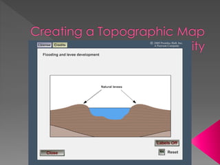
Creating a Topographic Map (Landform Feature)
1.
2. To identify a community’s flood risk, FEMA
conducts a Flood Insurance Study (FIS) every
few years.
The study includes
› statistical data for river flow,
› storm tides,
› hydrologic/hydraulic analyses,
› hurricane storm surge modeling, and
› rainfall and topographic surveys.
FEMA uses this data to create Flood Insurance
Maps (FIRMs), which show floodplain
boundaries that indicate different flooding
probabilities.