Architecture and Town Planning _Unit 4_SPPU_Survey and Transportation Managem...
M.U.R.P. work
1. Dweep BuchM.U.R.P.
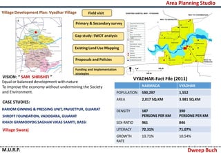
Village Development Plan: Vyadhar Village Field visit
Primary & Secondary survey
Gap study: SWOT analysis
Existing Land Use Mapping
Proposals and Policies
Funding and Implementation
strategies
VISION: “ SAM SHRISHTI ”
Equal or balanced development with nature
To improve the economy without undermining the Society
and Environment.
CASE STUDIES:
HARIOM GINNING & PRESSING UNIT, PAVIJETPUR, GUJARAT
SHROFF FOUNDATION, VADODARA, GUJARAT
KHADI GRAMODYOG SAGHAN VIKAS SAMITI, BASSI
Village Swaraj
VYADHAR-Fact File (2011)
NARMADA VYADHAR
POPULATION 590,297 1,552
AREA 2,817 SQ.KM 3.981 SQ.KM
DENSITY 187
PERSONS PER KM
390
PERSONS PER KM
SEX-RATIO 961 846
LITERACY 72.31% 71.07%
GROWTH
RATE
13.71% 10.54%
Area Planning Studio
2. Dweep BuchM.U.R.P.
PROPOSALS
Cooperative Society: Vyadhar
Ginning & Pressing Unit
Small Scale Industry
-Paper Making Industries
Infrastructure Development
-Water supply facility
-Sanitation and drainage
• Agriculture is the main source of income for people in
Vyadhar and surrounding villages
• Cotton production is done in 45% of area of Vyadhar
• Literacy rate is 71% but working population is 54%
• Marginal agricultural labourers are 30% of working
population
• People felt the need for source of income in nearby
area for their livelihood
• There is lack of basic amenities like sanitation and
drainage which need to be addressed
INDICATORS FOR PROPOSALS
Area Planning Studio
3. Dweep Buch
Regional Planning Studio
M.U.R.P.
Halol
SAVALI
WAGHODIA
VADODARA
PADRA
KARJAN
Regional Plan : Study area
covered base on water
shade of river Vishwamtri
Origin of Vishwamitri river,
Pavagadh- Halol
Administrative
boundary of
Halol,Savali, Vadodara,
Waghodia, Padra &
Karjan taluka
Sectors considered in
Regional Planning
Land-use study
Ecology
Infrastructure and heritage
Socio-economic studies
Demographics
4. Dweep Buch
Regional Planning Studio
M.U.R.P.
Layers Consideration for watershed management
Land-use suitability
Proposed land use with
considering
Natural aspects
5. Dweep Buch
Regional Planning Studio
M.U.R.P.
Suitability Analysis for different region
Identifying ecological sensitive area in Vishwamitri river watershed
6. Dweep Buch
Regional Planning Studio
M.U.R.P.
Taluka-wise
Population
projections
Tourism circuits
BARODA-SAVLI-HALOL-
JAMBUGHODA
BARODA-DABHOI-KARNALI-
TILAKWADA-GARUDESHWER-
KEVADIA COLONY-
SHOOLPANESHWER
This circuit has been divided in 5
sub circuits
Infrastructure Development
• Land suitability analysis before the stage of development
• Expert agency must conduct EIA under PPP model
• Considering the future projection the industries which is giving
more than 10000 employment is promoted.
• Green industries should have incentives for establishment of the
industries
• Toxic or chemical industries should be nearer to the effluent
channel
• Provision for vocational training sector for skill development for
entire region
• 70% employment should be from local level and 30% from
regional level.
POLICIES FOR PROMOTED INDUSTRIES
Demographics
Hence by considering all this aspects, efforts has been done to develop entire
region in terms of economy and ecology.
7. Dweep Buch
Metropolitan Planning Studio
M.U.R.P.
Cycle of Live able
condition
Preparation of value based Development plan of Vadodara city
Vision: Liveable Vadodara, 2041
A live-able city is an integral urban system with ecological, social,
economic and culture dimensions and their interconnections need to be
addressed as one system.
Goal
To integrate environmental concerns into economic
growth for becoming a healthy society
Objectives
• To provide land uses for new
development
• To address public infrastructure
issues and gaps
• To integrate inner city area with
overall development
• Conservation and development of
river front areas and water bodies
Approach towards liveable city
Choosing path of growth as
A→C rather than A→B→C
8. Dweep BuchM.U.R.P.
Metropolitan Planning Studio
Preparation of existing land use of Vadodara city
Inner city development
R1 (G+4) R2 (Low) R3
160.28 2.94 52.12 7.1 2.03 7.66 5.02 2.71 3.87 8.46 2.35 23.28 6.91 11.5 24.33
URDPFI
categories
Industrial
Area 8.46
Percentage 5
URDPFI
standards
12-14
Recreation and transportation
Balance 35-43
Green Open
42.74
27
Water bodies Agriculture
4 16
Restricted zonePublic Building Institutional Industrial
25.63
Public and semi-public Water bodies and agriculture
Slum Mix use Commercial
40 8
Residential Commercial
6.5864.19 12.68
35-40 4-5 14-16
Total area
Residential
2.03 7.66 5.02 2.71 3.87 8.46 2.35 23.28 6.91 11.5 24.33
Industrial
8.46
5
12-14
Recreation and transportation
Balance 35-43
Green Open
42.74
27
Water bodies Agriculture
4 16
Restricted zonePublic Building Institutional Industrial
25.63
Public and semi-public Water bodies and agriculture
lum Mix use Commercial
8
Commercial
6.5812.68
4-5 14-16
Calculation of existing land use
9. Dweep BuchM.U.R.P.
Metropolitan Planning Studio
Development Plan Considerations:
• Growth Direction of Vadodara
• Consideration of Existing Land use
• Physiography of study Area: Topography, Slope, Agriculture, Natural Elements.
• Identification of Area, Villages in the fringe area, Consideration of Area,
Population of the Land
• Consideration and reference of the URDPFI guide line
• Consideration of Natural Elements
• Consideration of Major Link roads at regional level
Development Strategies
River front development
Lake development
Public infrastructure specific to
recreation
Inner city development
Building Sector
10. Design Thesis(B.Arch.-2014) : An Astronomical Observatory and Research center, Bhuj – Kachchh
Research Thesis (M.U.R.P.-2016) : COASTAL REGULATION ZONE : Defining method for delineating
coastal zone boundary | case : Tuna village ( Gulf of Kachchh )
Dweep H. Buch
Architect
Master of Urban and Regional Planning
The Maharaja Sayajirao University of Baroda
+ 91-9429298826
dweepbuch91@gmail.com