2. 2
Index
Landslide phenomena
Indian Profile
Malpa
Cause and effect
Negligence
Cost Analysis
Efforts made by Government
Remedies
Mitigation measures for landslide
Case history
Govt. initiatives
3. 3
Mass movements generally downward and outward movement of hill slopes
Composed of rocks, soils, artificial fills or combination of all these materials
Along surfaces of separation by falling, sliding and flowing, either slowly or
quickly from one place to another.
Landslide?
Causative factors of Landslide
Natural Anthropogenic
Inherent External
• Change in slope/
• Land use pattern,
• Deforestation
• Deep excavation on slopes for
• Buildings, roads, canals and mining
• Inappropriate drainage system,
• Agricultural practices on steep slopes
• Earthquake
• Forest fire
• Wave action
• Rainfall
• Precipitation
• Volcanoes
• Gravity
• Litho logy
• Land form
• Land cover
• Geological
• Hydrological
conditions
• Slopes
4. 4
Type of Landslides
Falls:
Free-fall, bouncing, and rolling of materials
from steep slopes or cliffs.
Flows: Debris flow & avalanche: very rapid to
extremely rapid debris flow.
Creep: Slow, steady Downslope movement
of soil or rock
Slides:
1. Rotational 2. Translational 3. Topple
Rotational: Surface of rupture is curved concavely
upward (spoon shaped) and slump is created.
Translational: The mass of soil and rock moves
outward with little rotational movement & tilting.
Topple: A block of rock that tilts or rotates forward
and falls, bounces, or rolls down the slope
5. 5
Landslides Occurrence, Affects and Parts
Occurrence
1. On steep slopes
2. Failure of drainage system
3. Where certain geologic
conditions exist
Affects of land slide
1. Life threatening & causes injuries
2. Property damage- Resources like
1. Houses,Forests, dams, Roadways,
2. Water supply,
3. Sewage disposal systems
3. Negative economic affect-
1. Loss of property value,
2. Medical cost
3. Repair of structures,
4. Disruption in transportation routes,
5. Indirect cost of loss of livestock and
resources
4. Compromised quantity and
quality of land
5. Costly Geotechnical studies
For engineering projects to access a
stabilize potentially dangerous sites
Parts of Land slide
Crown: un-displaced material still in
place
Main scarp : A steep surface on the
undisturbed ground at the upper edge
of the landslide
Crown
Crown cracks
Main body
Foot
Toe
Transverse crack
Radial
crack
Surface of separation
Surface of
Rupture
Head
Transverse ridge
6. 6
Indian Profile Indian Profile
Annual rainfall
India
Zone II up to 4.9
Zone III up to 6.9
Zone IV up to 7.9
Zone V 8 and more
Seismic zones
India
landslide zones
India
7. 7
Indian Profile
Himalayan Tragedies
Aug 12:
69 killed near
Rudraprayag
Aug 19:
>25 killed near
Ukhimath
Aug 19:
6 killed in the hills
of Dehradun Dist.
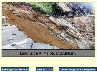
18 august 1998, at 3:00 a.m. MALPA, Uttarakhand
Massive rock fall killed 210 people in the Kali Valley
15 M high heap of debris
The village was wiped out in the event.
Disrupted Road network to Man-Sarovar
Prolonged Heavy rains 13-16 Aug, decreased cohesion and
shearing resistance, leading to instability, slope failure and free
falls of rock masses on the dip slope 60°–70° north-eastward
Landslide location
8. 8
Malpa Tragedy
Rainfall in the month of August
Malpa Gad
Before Landslide
Malpa Gad
after Landslide
13 14 15 16 17 18 19
9. 9
Tectonic setting of the Kali Valley
Tectonic setting of the Kali Valley
Tethyan Super Group Tethyan Sediments
Tethyan Shear Zone
Martoli Formation Grey quartzite schist
Pindhari Formation Calc-silicate
Pandukeswar Formation Quartzite
Joshimath Formation Migmatite
Main central Vaikrita Thrust
Malpa
1916 Earthquake
magnitude 7.5
1954 Earthquake
magnitude 6.2
Causes of land slide
Malpa located along major fault
neo-tectonic strike-slip movements
Extreme shear of rocks and
Prolonged heavy rain fall
10. 10
MALPA Rock Fall Scar
(3000M)
Debri Channel II
Debri Channel III
Debri Channel
I
Dam Lake
Old Landslide Deposit
Mansarovar Yatri
CampSite 1998
Malpa Village
PWD Rest House
Old stream
Kali River
event took about 2.30 hrs,
00.30 AM to 3.00 AM on
August 17–18, 1998
11. 11
Cost Analysis
1. Personal interviews, and field surveys: To collect primary information, and
extent of losses
2. land-use pattern study: from the records of State Govt. tehsil office, Dharachula
3. Past events: 1977 Tawaghat landslide took a toll of 44
4. Total cost involved
– number of persons and animals killed in the accident
– annual income by earned porters and horses and mules keepers
– disruption to communication routes Landuse at Malpa
Cultivable waste land
34%
Land under cultivation
22%
Settlement
17%
River
16%
Streams
4%
Footpath
7%
Cultivable waste land Land under cultivation Settlement River Footpath Streams
• Public cost:
– Compensation paid for the loss of
human and animal lives by the
Govt.
– cost of lost public properties i.e.
KMVN huts, PWD Office building,
army huts, transport routes, etc.
• Private cost:
– cost incurred by the local people,
for which no compensation was
paid by the govt.
Cost not included:
rescue operation,
investigation costs,
>65% cost is due to damage to settlements &
livestock population
could have been minimized if the hazard prone
areas had been timely recognized
12. 12
Damage and Estimated Cost
Table 1. Damage as per official records at Malpa
Particulars Damage (no./ Area Ha.)
Missing persons ( M182 M+ 25 F)=207
Animals 69
Houses 5
Huts (KMVN*+PWD*+Army) 2+2+1)=5
Wooden Bridge 1
Cultvable Land 0.408 Ha
Barran Land 1.701 Ha
Total Land 2.951Ha
Estimated Cost of Landslide Damage at Malpa
Particulars Public Cost
(Rs.)
Private Cost
(Rs.)
Total Cost
(Rs.)
Livestock 1,38,000 9,22,650 10,60,650
Setlement 21,55,000 4,90,000 26,45,000
Agricultual land - 60,430 60,430
Barran Land - 1,08,000 1,08,000
Plants/Vegetatio
n
- 28,500 28,500
Wooden Bridge 1,00,000 - 1,00,000
Porter’s Income - 3,26,700 3,26,700
Other Items 6,00,000 7,64,923 13,64,923
Total 29,93,000 27,01,203 56,94,203
Source: Tahsil Office, Dharachula and field survey, 1998.
*KMVN: Kumaun Mandal Vikas Nigam , PWD: Public Works Dept.
Missing persons included: 118 local people,
(207) 60 pilgrims,
12 Nepal citizens,
8 Indo-Tibetan Border Police (ITBP) personnel,
5 Staff members of KMVN,
4 Police personnel,
As per official records: 69 animals,
As per Field Survey: 125 Domestic animals
Private cost not compensated by Govt.
13. 13
Reasons for Malpa tragedy
Himalayan ranges are susceptible to landslides, rock fall and flash floods.
Responsible reasons for tragedy:
Negligence of the recommendations made by the geological experts
overlooking the early signals of the catastrophe
Knowledge gaps:
Non-availability of scientifically collected data related to
Past events,
Landslide costs, and
Absence of hydro-meteorological data, etc. which withheld advance
planning for hazard mitigation.
Awareness among locals
educate the people about mountain risks and hazards
Possible ways of living with these hazards.
Site-specific hazard zone maps to give a broad picture, useful for
regional planning.
Mitigation measures
To reduce the risk of such events in the future.
Effective R&D efforts for management of the natural mountain
environment. Programmes for identification of hazard zones,
Regular monitoring of deformation patterns
14. 14
Landslide Risk Management
• Landslide Classification based on
– Velocity (m/sec) of landslides,
– depth of landslides: surface, shallow, deep, and very deep
– Area affected by landslides: volume of landslide and mud flow cubic meter
• Principle Landslide driving force is the gravitational force
• Identifying Landslide Areas: costly procedures as surveying, monitoring or soil testing, not
affordable/feasible in rural regions
Simpler effective methods are:
Existing or historic landslides
Hollow Areas at the base of slopes, top of
a slope or cut slope,
V-shaped valleys, canyon bottoms, and
steep stream channels
Fan shaped areas of sediments and
boulders accumulation at the outlet of
canyons
Areas with large boulders (2’-20’diameter)
suspended on soil or adjacent to creeks
Logjams in streams or Steep hill slopes
above a home or hamlet
Areas by excavation, Steep road cuts,
sunk or down-dropped road beds,
Moderate slopes exposed to high water
flow
Potential landslide risk indicators:
New cracks or unusual bulges in the
ground, roads or pavements
Movement of furniture in relation to house
Sticking doors/windows,
Soil moving away from foundations
Tilt or crack in floors/foundations
Broken underground utilities
Leaning telephone poles, trees, retaining
walls or fences
Offset fence lines or retaining walls
Sunken or displaced road surfaces
15. Five strategies comprising:
i) Treating vulnerable slopes and
existing hazardous landslides.
ii) Restricting development in landslide-
prone areas.
iii) Preparing codes for excavation,
construction and grading.
iv) Protecting existing developments.
v) Monitoring and warning systems.
vi) Putting in place arrangements for
landslide insurance and compensation
for losses.
Hazard zonation mapping involves:
i) Creation of landslide inventory.
ii) Selecting scales for mapping
depending upon end-user requirements.
iii) Selecting landslide hazard zonation
methodologies for different scales.
iv) Multi-hazard integration especially
integrating seismic hazard.
v) Prioritisation of areas for landslide
hazard zonation mapping.
vi) Landslide risk zonation.
15
Hazard zonation mapping
16. Highlights of Important Recommendations
i) Development and continuously updating the inventory of landslide
ii) Identification and prioritisation of the areas and mapping in consultation with the Border
Roads Organisation, state govts. and local communities.
iii) Taking up pilot projects in different regions of the country with a view to carry out detailed
studies and monitoring of selected landslides to assess their stability status and estimate risk.
iv) Setting pace setter examples for stabilisation of slides and also setting up early warning
systems depending on the
risk evaluation and cost-benefit ratio.
v) Site specific studies and encourage state governments to carry out treatment measures
vi) Institutional mechanisms to generate awareness and preparedness among various
stakeholders.
vii) Education, training of professionals and capacity development of organisations working
in the field of landslide management.
viii) Capacity development and training to make the response regime more effective.
ix) Development of new codes and guidelines on landslide studies and revision of existing ones.
x) Establishment of an autonomous national centre for landslide research, studies and
management.
Monitoring of landslides includes:
i) Surface measurements of landslide activity.
ii) Sub-surface measurements of landslide activity.
iii) Total regime measurements.
16
Early warning :
i) Scientific and technical communities.
ii) Government authorities and civil agencies.
iii) Local communities.
17. 17
Landslide Risk Management
The Malpa landslide tragedy brought the attention of the Central Government to the
problem of landslides
3 national level task forces constituted by Dept. of Sc.& Tech.
Enactment of disaster management act in 2005,
Establishment of National Disaster Management Authority (NIDM) under the
chairmanship of Hon’ble Prime Minister
NIDM mandated to organize training programmes, seminars, workshops and
conferences on disaster management
International Recognition to NIDM
International Authority Recognition to NIDM
International Consortium on Landslides (ICL)
Global Promotion Committee
World Centre of Excellence on Landslide
Disaster Reduction (WCoE-LDR)
International Progarmme on Landslides by
International Strategy for Disaster Reduction
(IPL-ISDR),
For training and capacity development for
landslide risk reduction
Training Module on Comprehensive Landslides Risk Management
Developed by Dr. Surya Prakash. Asso. Prof. NIDM, New Delhi
Covers
Morphology of landslide
Landslide scenario in India and other countries
Impact and hazard management in India
18. 18
Cause & effects of landslides
Cause Effect
De-aligned Retaining walls
Ruptured joints in pipelines
Sudden and fast drawdown
resulting Landslides
Monitoring wall cracks using
paper slips with markings
Rock cutting Agricultural practices on hills
19. 19
Minimize the effect
• Role of Planners and Decision Makers
• Implementation of regional hazard and risk assessments into land planning policies.
• Slope stability issues and zoning for future development is directed towards areas with
a low risk of slope instability.
• Engineering and geotechnical investigation defining landslide hazard and risk at site
specific levels of investigation.
• Mapping of landslide vulnerability to help the emergency response scenarios.
Net barriers to reduce the impacts
of debris flow,