State of hydrogeological risks in north western rwanda
•
1 like•218 views

The document describes the current situation of hydrogeological disasters in Rwanda.

Recommended
Recommended
More Related Content
What's hot
What's hot (20)
Viewers also liked
Viewers also liked (15)
Similar to State of hydrogeological risks in north western rwanda
Similar to State of hydrogeological risks in north western rwanda (20)
Recently uploaded
Recently uploaded (20)
State of hydrogeological risks in north western rwanda
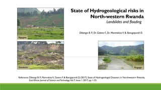
- 1. State of Hydrogeological risks in North-western Rwanda Dibanga B. P., Dr. Gatera F., Dr. Manirakiza V. & Bavugayundi D. Landslides and flooding Bigogwe MugogoGatokoto Reference: Dibanga B. P., ManirakizaV., Gatera F. & Bavugayundi D. (2017).State of Hydrogeologial Disasters in Northwestern Rwanda, East African Journal of Science andTechnology,Vol.7, Issue 1, 2017, pp. 1-25.
- 2. Presentation outline 1. Introduction 2. Methodology 3. Overview of factors of hydrogeological risks 4. Findings and discussion 5. Conclusion
- 3. Disasters constitute a huge threat to people’s lives, settlements, infrastructures, economic activities, … 1.Introduction Examples of some reported damages cases • Flooding of 8 ha maize, 4 houses & 2 schools destroyed in May 2010: Muhanga; • 60 ha of rice, 2 victims, 2 fishing dumps in April 2010: Kamonyi; • 118 houses: 13/03/2009; Nyakarenzo/ Rusizi; • 57 families displaced in Janja & 186 in Busengo sectors: 28/12/2009, Gakenke; • 67 houses: 13/01/2010, Rutonde / Rulindo • 215 houses, 2 churches, 855 ha: 03/10/2009, Cyanzarwe / Rubavu; • 258 houses, 45 ha, 2 victims, 15 bridges: May 2010, Bigogwe / Nyabihu • 3 days road blocked at Nyabarongo : 2016 • 50 victims of landslides: 08/05/2016, Gakenke.
- 4. Human physical Factors: topography, rainfall, vegetation cover, bedrock, soils, human settlements & activities. Most affected zones: High mountainous regions: Northern & Western provinces. Challenge: Physical factors are associated with overuse of soils & exploitation of marginal lands due to high population density & lack of land for agriculture. Landslides & floods: most hydrogeological risks in Rwanda. Various types of disasters: landslides, floods, earthquakes, volcanic eruptions, storms, tornadoes, tsunamis, wildfires. Introduction
- 5. Study area: Northwestern Rwanda: Rulindo, Gakenke, Musanze, Nyabihu & Rubavu districts. Research objective : To analyse the factors of hydrogeological risks in north-western Rwanda from different physical and human factors and propose sustainable measures for their prevention. Introduction
- 6. 2. Methodology Three steps: 1. Inventory of recent disasters in all districts of Rwanda : period from 2007 to 2012 2. Identification of disasters prone zone: North-western Rwanda 3. Empirical research in selected zones & sites.
- 7. Observation & interviews • Information on the state of damages, forms of floods and landslides, land use techniques, nature of topography & settlement. • Identification of disasters prone area: historical records & testimonies from local communities and population. • Information on the period, the damages and the extent to which the hydrogeological risk occurred. • Photographs & maps Research techniques : Observation, interviews & study of the risk Methodology
- 8. Study of Landslide: location, environmental setting, description of characteristics: size, soil profile, nature of the rocks & additional factors like water springs. Study of Flood: identification of drained & flooded surface, origin of water flow and environmental setting. Damages: description, quantification and social economic impact evaluation (information from population). Empirical study of the risk: measurement and analysis Methodology
- 9. 3. Overview of the factors of hydrogeological risks 1. Nature of rocks 2. Nature of soil: type & texture 3. Topography 4. Vegetation cover 5. Rainfall 6. Human features: population & land use
- 10. i. Nature of rocks - On the heights and the slopes: granites & pegmatites - In the depressions and lowlands: volcanic rocks & quartzites Resistant rocks and steep slopes lead to formation of a thin layer of weathering and this causes multiple landslides during the rainy season. Factors of hydrogeological risks
- 11. ii. Nature of soil Predominant types of soil • Noth-west zone: andosols • Central & southern zone: Ferralsols, cambisols, alisols, gleysols Soil layers stratification favours water stagnation in lower horizons leading to suffosion (water springs) & Landslides Factors of hydrogeological risks
- 12. Predominant soil texture: Clay soils are not permeable and cause floods in lowlands Sandy & coarse loams are easly detachable and favour landslides in high slope zones - Clay - Sand - Silt - Loam Factors of hydrogeological risks
- 13. • High altitude 2000 - 4,500 m • Steep slopes : 15 – 50 % iii. Topography Factors of hydrogeological risks The greater the height, steepness and convexity of slopes, the greater the volumes of the landslides. Floods occur in lower altitude zones of Musanze and Nyabihu and landslides in other zones.
- 14. • Challenge: deforestation & overuse of uncovered soils • Large part is located in deforestation area which should be intense forest zone (de Martonne aridity index (IdM)). Aridity index (I): - 30,3 in 2013 - 38,8 in 2014 ! when I > 30 : dense forest iv.Vegetation cover Poor vegetation cover is not a consequence of droughts, but a consequence of intensive human activities. Factors of hydrogeological risks
- 15. • Highest rainfall > 1200 mm ( eg. 1487 mm volcanic area). • 8 months of rain season : from September to May; • Atmospheric drought lasts from July to August; • The soil drought covers only July; v. Rainfall Factors of hydrogeological risks There is no hydrological drought in the region
- 16. • Fertile highlands (Rukiga, Buberuka) • Densely populated area District Density Rulindo 509 Gakenke 481 Musanze 695 Nyabihu 556 Rubavu 1041 vi. Human features Population density Factors of hydrogeological risks Population
- 17. • Dispersed settlements • Scattered homesteads, • Subsistence farming • Traditional land use practices & techniques Land degradation and soil erosion. Land use Factors of hydrogeological risks
- 18. 4. Findings & discussion Nr Site Nature of risk District Sector 1 Bushoki Landslide Rulindo Bushoki 2 Gashenyi Landslide Gakenke Gashenyi 3 Busengo* Landslide Gakenke Busengo 4 Mugogo* Flood Musanze Busogo 5 Gatokoro* Landslide Nyabihu Rambura 6 Bigogwe* Landslide & Flood Nyabihu Bigogwe 7 Rusongati Landslide Rubavu Kanama 8 Nyundo & Mahoko Flooding control Rubavu Nyundo Location of studied sites * Discussed sites in this presentation
- 19. i. Busengo rotational landslide (slump) Environmental setting • Loose materials on the steep slopes (30 %) • Near Gaseke river bed (100 m) • Size: 36 m in width and more than 58 m in length • Soil profile: 3 layers & no identifiable bedrock - upper layer: fine colluvial materials (40 cm) - medium layer: coarser materials (30 cm) - lower layer : sandy materials • Water-springs at the bottom of the main scarp • A settlement at the top of the hill • No forest but grass vegetation cover
- 20. Preventive measures - Re-forestation programme - Integrated management of river banks - Resettlement of the population Causes of Busengo landslide - High gradient of the slope - River banks undermining - Unstable colluvial soils materials - Water springs and undrained rain water from the settlement on the top of the hill
- 21. ii. Gatokoro landslide (Rambura) Environmental setting • Located on a pegmatitic granite • Steep terrain, slope of 27 %. • Soil profile: sandy soils with 4 layers: - upper layer of colluvium (60 cm) - stone layer (40 cm) - weathered rock - pegmatitic parental rock. • Weathering of parental rock results into sand (white micas, quartz. ) • The movement of land is about 7m.
- 22. Causes of Gatokoro landslide • Sandy soils (highly permeable) • Many water springs that cause sliding • Rainwater and undrained rain water from the top of hill that speed up sliding Preventive measures • Re-forestation, • Resettlement of people • Engineering works (gabions, stone walls) to avoid falling rocks.
- 23. • Floods of Mizingo & Kinoni rivers in Mizingo & Mugogo marshlands • Frequent floods mainly in November and April • Site bordered by the hills and mountain with steep slopes, densily populated due to fertile volcanic soil • High rainfall causes excessive runoff which leads to flooding. iii. Bigogwe & Mugogo floods
- 24. Combined factors : • Escarped topography that does not facilitate water infiltration in soil, • Limited soil permeability (clay and silt soils) • Intensive rainfall & Deforestation • Densely populated watershed • Accelerated runoff: overgrazing & cultivation Measures: • Afforestation and re-afforestation, • Terracing of slopes, Nyundo, protection against flooding Nyundo abandon ned health center due to Sebeya flooding Construction along the banks of rivers and widening river channel through dredging. Eg: Sebeya - Nyundo
- 25. 5. Conclusion • All factors: nature of rocks, slopes, soil granulometry, rainfall intensity, vegetation cover and human activities act together to contribute to hydrogeological risks in the north-western region. • Rainfall is a triggering factor because landslides and floods recurrently happen during the rainy season. • Even if all natural factors may relatively be the same, disasters do not happen in all slopes to the same extent. • Land use is therefore a main factor of disasters in Rwanda 1. Research contribution
- 26. 2. Preventives measures for sustainable land use • Resettlement, afforestation and appropriate land use techniques. • Careful analysis of where to locate a settlement because on each top of the slope where occurred a landslide there is a settlement. • Slopes of over 20° are not suitable for settlement and agriculture, as well as depressions surrounded by steep slopes and colluvial soils. • Control of population growth and its adequate distribution. • Sensitization of the population to bad effects of hydrological risks, their prevention and appropriate and sustainable land use.
- 27. The research team thanks you Rusongati bridge