1. Course Title : Geogriphical Information System Course Code : CACS454
Semester : BCA 8th
Sem
Unit 1 Introduction to GIS
Unit 1: Introduction 6 Hrs.
o Definition, Functions and Applications of GIS
o GIS as Information System
o Component of GIS
o Nature and Sources of GIS data.
o Spatial Data
o Recent trends and future of GIS
Geogriphical Information Technologies
There are mainly following three technologies for locating, pinpointing and managing Spatial data.
Note: Spatial data can be referred to as geographic data or geospatial data. It provides the information that identifies
the location of features and boundaries on Earth.
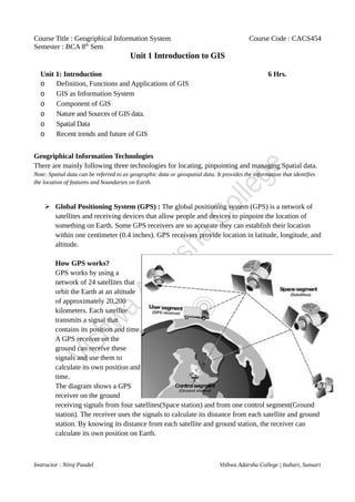
➢ Global Positioning System (GPS) : The global positioning system (GPS) is a network of
satellites and receiving devices that allow people and devices to pinpoint the location of
something on Earth. Some GPS receivers are so accurate they can establish their location
within one centimeter (0.4 inches). GPS receivers provide location in latitude, longitude, and
altitude.
How GPS works?
GPS works by using a
network of 24 satellites that
orbit the Earth at an altitude
of approximately 20,200
kilometers. Each satellite
transmits a signal that
contains its position and time.
A GPS receiver on the
ground can receive these
signals and use them to
calculate its own position and
time.
The diagram shows a GPS
receiver on the ground
receiving signals from four satellites(Space station) and from one control segment(Ground
station). The receiver uses the signals to calculate its distance from each satellite and ground
station. By knowing its distance from each satellite and ground station, the receiver can
calculate its own position on Earth.
Instructor : Niroj Paudel Vishwa Adarsha College | Itahari, Sunsari
2. Course Title : Geogriphical Information System Course Code : CACS454
Semester : BCA 8th
Sem
Unit 1 Introduction to GIS
There are three main types of errors that can affect GPS data:
• Positional error: This is the error in the GPS receiver's calculated position. It is
caused by a number of factors, including the distance between the receiver and the
satellites, the accuracy of the satellite clocks, and the effects of the Earth's
atmosphere.
• Time error: This is the error in the GPS receiver's calculated time. It is caused by
the same factors that affect positional error, as well as the fact that the clocks on the
satellites are not perfectly synchronized.
• Multipath error: This is the error caused by the reflection of GPS signals off of
buildings, trees, and other objects. This can cause the receiver to calculate a false
position.
➢ Remote Sensing : Remote Sensing is acquisition of geographical information about an
object/area without being physical contact with it. This can be done using a variety of
sensors, such as cameras, radar, and lidar. These sensors measure the energy that is reflected
or emitted from the object or area being studied. The energy measurements are then used to
create images or maps of the object or area.
Types of Remote Sensing
a) Active remote sensing uses a sensor that emits energy that is then reflected or emitted
from the object or area being studied. The most common type of active remote sensing is
radar. Radar works by emitting a beam of radio waves and then measuring the time it takes
for the waves to return to the sensor. The time it takes for the waves to return depends on the
distance to the object or area being studied. Radar can be used to see through clouds and
darkness, making it ideal for applications such as weather forecasting, search and rescue,
Instructor : Niroj Paudel Vishwa Adarsha College | Itahari, Sunsari
3. Course Title : Geogriphical Information System Course Code : CACS454
Semester : BCA 8th
Sem
Unit 1 Introduction to GIS
and military surveillance.
Example:
Radar: Used to track weather patterns, map terrain, and detect objects in low visibility
conditions.
LiDAR: Used to create 3D maps of the Earth's surface.
Infrasound: Used to detect earthquakes and other seismic events.
b) Passive Remote Sensing uses a sensor that measures the energy that is naturally emitted
or reflected from the object or area being studied. The most common type of passive remote
sensing is optical remote sensing, which uses cameras to measure the visible and near-
infrared light that is reflected from the Earth's surface. The amount of light that is reflected
by an object or area depends on its properties, such as its color, shape, and texture. This
allows researchers to "sense" things about the Earth, such as the type of vegetation, the
amount of water, and the presence of pollutants.
Example:
Optical remote sensing: Used to map land cover, monitor vegetation, and track changes in
the Earth's environment.
Infrared remote sensing: Used to map surface temperatures, detect hot spots, and identify
objects that are obscured by clouds.
Microwave remote sensing: Used to map soil moisture, measure snow cover, and track
ocean currents.
➢ Geographical Information System(GIS): [will be discussed in next section]
Introduction to Geographical Information System(GIS)
Basic Terms
System: A group of connected entities and activities which interact for a common purpose
Information system: A set of processes, executed on raw data, to produce information
which will be useful for
decision making
Spatial data: Geographically referenced data sets
Introduction
Instructor : Niroj Paudel Vishwa Adarsha College | Itahari, Sunsari
4. Course Title : Geogriphical Information System Course Code : CACS454
Semester : BCA 8th
Sem
Unit 1 Introduction to GIS
Geographic information systems (GIS) (also known as Geospatial information systems) is
a particular form of information system applied to geographical data. GIS are Computer
Software and hardware systems that enable users to capture, store, analyze and manage
spatially referenced data. This includes data that has a location component such as a
physical address, geographic coordinates, or a shape on a map.
It enables users to integrate and analyze different types of data from various sources,
facilitating better decision-making in a wide range of applications.
Definitions of GIS
1. GISs are simultaneously the telescope, the microscope, the computer, and the
Xerox machine of regional analysis and synthesis of spatial data. (Ron Abler,
1988).
2. "GIS is an enabling technology that facilitates the integration of geographically
referenced data and assists in their analysis, visualization, and interpretation to
support better decision-making." - National Academy of Sciences.
3. "GIS is a platform for creating, managing, analyzing, and sharing geographic
information." - United States Geological Survey (USGS).
4. "GIS is a system of computer hardware, software, data, people, organizations, and
institutional arrangements for collecting, storing, analyzing, and disseminating
information about areas of the earth." - Michael F. Goodchild, a prominent GIS
researcher.
GIS as Information System
GIS is considered an information system because it is
designed to collect, store, analyze, and present spatial and
non-spatial data. A GIS system integrates hardware,
software, and data to capture, store, and manage
spatial data. It allows users to combine different
types of data from different sources and use them
to make informed decisions.
GIS, as an information system, utilizes various
technologies such as remote sensing, GPS, computer
Instructor : Niroj Paudel Vishwa Adarsha College | Itahari, Sunsari
5. Course Title : Geogriphical Information System Course Code : CACS454
Semester : BCA 8th
Sem
Unit 1 Introduction to GIS
cartography, spatial database management systems, and computer-aided design (CAD) to
collect, store, manage, analyze, and present spatial data.
Remote sensing involves the use of satellites or aircraft to capture images of the Earth's surface,
which can be used to create maps or identify changes in the environment over time. These images
are integrated into the GIS system to provide a visual representation of the data.
GPS, or Global Positioning System, is used to collect precise location data that is integrated into the
GIS system. GPS technology is widely used in the field, enabling data collection in real-time and
improving the accuracy of spatial data.
Computer cartography is used to create and edit maps in a digital format, which can be integrated
into the GIS system. These digital maps can be layered with other spatial data to provide a
comprehensive view of a geographic area or phenomenon.
Spatial database management systems (DBMS) are used to store and manage spatial data, enabling
users to query and analyze data in a way that is not possible with traditional databases. Spatial
DBMS allows GIS users to perform spatial analysis and modeling, which helps in understanding
patterns, relationships, and trends in the data.
Computer-aided design (CAD) software is used to create detailed drawings of geographic features
or infrastructure, such as roads, buildings, or utilities. These CAD drawings are integrated into the
GIS system to provide a comprehensive view of the data.
In summary, GIS as an information system utilizes various technologies to collect, store, manage,
analyze, and present spatial data. These technologies, including remote sensing, GPS, computer
cartography, spatial database management systems, and CAD, enable users to integrate different
types of data from multiple sources and analyze them in a way that is not possible with traditional
methods. By combining these technologies, GIS provides a powerful tool for decision-making in a
wide range of applications, from environmental management to urban planning to natural resource
management.
Components of GIS
GIS (Geographic Information System) is a complex system with various components that work
together to manage and analyze spatial data. These components include hardware, software, data,
people, and processes.
Hardware: The hardware component of GIS refers to the physical equipment used to operate the
system. This includes computers, servers, printers, scanners, mobile devices, and GPS receivers.
The hardware must be powerful enough to run the GIS software and handle large amounts of data.
The hardware must also be compatible with the software and data used in the GIS.
Instructor : Niroj Paudel Vishwa Adarsha College | Itahari, Sunsari
6. Course Title : Geogriphical Information System Course Code : CACS454
Semester : BCA 8th
Sem
Unit 1 Introduction to GIS
Software: GIS software is used to manage, analyze, and visualize spatial data. This includes
desktop, web-based, and mobile applications. The software is used to create and edit maps, query
spatial data, perform spatial analysis, and create reports. The software must be compatible with the
hardware and data used in the GIS.
Data: GIS data includes all the spatial data that is used in the GIS system. This includes digital
maps, satellite imagery, aerial photographs, GPS data, census data, land use data, and environmental
data. The data can be in various formats, such as vector, raster, and tabular data. The data must be
stored in a database management system that is designed to handle spatial data.
People: GIS users are the people who operate, maintain, and manage the GIS system. This includes
GIS professionals, data analysts, IT personnel, and end-users. GIS professionals are responsible for
designing and implementing the GIS system, managing the data, and performing spatial analysis.
Data analysts are responsible for interpreting the data and creating reports. IT personnel are
responsible for maintaining the hardware and software used in the GIS system. End-users are the
people who use the GIS system to make decisions and solve problems.
Processes: The process component of GIS includes the workflows and procedures used to manage
and analyze spatial data. This includes data collection, data integration, data analysis, and data
dissemination. The processes must be designed to ensure the accuracy and quality of the data used
in the GIS system.
Some of the key GIS software components are as follows:
GIS Data Capture: This software is used to capture the spatial data used in GIS. It includes
various tools for digitizing, scanning, and importing data. GIS data capture software can be used to
capture data from various sources, such as satellite imagery, GPS, and aerial photographs.
GIS Data Management: This software is used to manage the spatial data used in GIS. It includes
tools for organizing and storing spatial data in a database. GIS data management software can be
used to create and manage metadata, which is information about the spatial data.
GIS Analysis: GIS analysis software is used to perform spatial analysis and modeling. It includes
tools for measuring distance and area, creating buffers, and conducting overlay analysis. GIS
analysis software can be used to create maps that display spatial patterns and relationships.
GIS Visualization: GIS visualization software is used to create and display maps and other spatial
data visualizations. It includes tools for creating different types of maps, such as thematic maps,
Instructor : Niroj Paudel Vishwa Adarsha College | Itahari, Sunsari
7. Course Title : Geogriphical Information System Course Code : CACS454
Semester : BCA 8th
Sem
Unit 1 Introduction to GIS
topographic maps, and street maps. GIS visualization software can also be used to create 3D
visualizations and animations.
GIS Web and Mobile Applications: GIS web and mobile applications allow users to access GIS
data and tools from anywhere with an internet connection. Web applications can be used to share
GIS data with a wide audience, while mobile applications can be used to collect spatial data in the
field.
In summary, GIS is a complex system that includes various components, including hardware,
software, data, people, and processes. These components work together to manage and analyze
spatial data, enabling users to make better decisions and solve problems in a wide range of
applications. The software components of GIS include data capture, data management, analysis,
visualization, and web and mobile applications.
Applying GIS to any business or organizational problem/ Concept of applying GIS
A simple five step process lets us apply GIS to any business or organizational problem
that requires a geographic decision. The steps are as follows:
• Ask: What is the problem you are trying to solve or analyze, and where is it
located?, Framing the question will help you decide what to analyze and how to
present the results to your audience.
• Acquire: Next we need to find the data needed to complete our project. The type
of data and the geographic scope of our project will help direct our methods of
collecting data and conduction the analysis.
• Examine: We will only know for certain that our data is appropriate for study
after thoroughly examining it. This includes how the data is organized, how
accurate it is, and where the data came from?
• Analyze: Geographic analysis is the core strength of GIS. Depending on our
project, there are many different analysis methods to choose from. GIS modeling
tools make it relatively easy to make these changes and create new output.
• Act: The results of our analysis can be shared trough reports, maps, tables, and
charts and delivered in printed format or digitally over a network or on the web.
We need to decide on the best means for presenting our analysis, and GIS makes
it easy to tailor the results for different audiences.
Functions of GIS
GIS (Geographic Information System) has several functions that make it an essential
tool in various fields. Some of the key functions of GIS are as follows:
Instructor : Niroj Paudel Vishwa Adarsha College | Itahari, Sunsari
8. Course Title : Geogriphical Information System Course Code : CACS454
Semester : BCA 8th
Sem
Unit 1 Introduction to GIS
1. Data Capture: GIS can capture various types of spatial data, including maps, satellite
imagery, aerial photographs, GPS data, and environmental data. This data can be stored in a
GIS database and used for analysis and visualization.
2. Data Management: GIS can manage large volumes of spatial data, including organizing and
storing data, creating metadata, and maintaining data quality.
3. Data Analysis: GIS can perform various types of spatial analysis, including buffering,
overlay analysis, interpolation, and modeling. These analyses can help identify spatial
patterns and relationships, predict outcomes, and make better decisions.
4. Data Visualization: GIS can create various types of maps and other spatial data
visualizations, including thematic maps, topographic maps, and 3D visualizations. These
visualizations can help communicate complex spatial information to a wide audience.
5. Geocoding: GIS can assign geographic coordinates to non-spatial data, such as addresses,
and integrate it into a spatial database. This allows for easy analysis and visualization of the
data.
6. Routing and Navigation: GIS can calculate the optimal route between two points and
provide turn-by-turn directions. This can be used for navigation, logistics planning, and
emergency response.
7. Land Use Planning: GIS can help identify suitable locations for development and
conservation, assess environmental impacts, and facilitate stakeholder engagement.
8. Emergency Management: GIS can help emergency responders quickly identify affected
areas, assess damages, and allocate resources during a crisis.
9. Natural Resource Management: GIS can help manage natural resources, including forestry,
agriculture, and water resources. This includes monitoring and predicting environmental
changes, identifying areas at risk, and developing strategies to mitigate risks.
10.Business Intelligence: GIS can help businesses make informed decisions by analyzing
customer demographics, market trends, and other spatial data.
Overall, the functions of GIS are vast and diverse, making it an essential tool in various fields,
including urban planning, transportation, public health, environmental management, and business.
GIS helps organizations and individuals make informed decisions based on spatial data analysis and
visualization, improving outcomes and reducing risks.
Applications of GIS
Some of the key applications of GIS are as follows:
1. Urban Planning: GIS is widely used in urban planning to identify suitable locations for
development, assess the impact of new developments on the environment, and manage land
Instructor : Niroj Paudel Vishwa Adarsha College | Itahari, Sunsari
9. Course Title : Geogriphical Information System Course Code : CACS454
Semester : BCA 8th
Sem
Unit 1 Introduction to GIS
use. It can help in creating zoning maps, assessing the impact of land use on the
environment, and identifying infrastructure needs.
2. Transportation: GIS is widely used in transportation planning and management. It can be
used to identify transportation routes, optimize routing and scheduling, and evaluate
transportation infrastructure needs. It can also be used to analyze traffic patterns and identify
high-risk accident areas.
3. Environmental Management: GIS is used to manage natural resources and protect the
environment. It can be used to monitor environmental changes, identify areas at risk, and
develop strategies to mitigate risks. It can also be used to assess the impact of development
on the environment and manage wildlife habitats.
4. Public Health: GIS is used to manage and analyze health-related data. It can be used to track
the spread of diseases, identify high-risk areas, and develop strategies to prevent the spread
of diseases. It can also be used to manage public health resources, such as hospitals and
clinics.
5. Emergency Management: GIS is used in emergency management to quickly identify
affected areas, assess damages, and allocate resources during a crisis. It can also be used to
develop evacuation plans and assess the risk of natural disasters.
6. Business: GIS is used in business to analyze customer demographics, market trends, and
other spatial data. It can be used to identify suitable locations for business expansion, assess
the impact of new businesses on the environment, and optimize distribution routes.
7. Archaeology: GIS is used in archaeology to map excavation sites, manage excavation data,
and analyze spatial relationships between artifacts and features.
8. Agriculture: GIS is used in agriculture to manage and analyze data related to soil, crops, and
weather patterns. It can be used to identify suitable locations for crop growth, optimize
irrigation and fertilizer use, and predict crop yields.
9. Law Enforcement: GIS is used in law enforcement to map crime data, identify high-risk
areas, and develop strategies to prevent crime. It can also be used to manage resources, such
as police stations and patrol routes.
10.Education: GIS is used in education to teach geography and spatial analysis skills. It can be
used to create interactive maps, analyze spatial relationships, and teach critical thinking
skills.
Nature and Sources of GIS data.
GIS data can come from a variety of sources and can be of different nature. The nature and sources of
GIS data are listed and briefly explained below.
Instructor : Niroj Paudel Vishwa Adarsha College | Itahari, Sunsari
10. Course Title : Geogriphical Information System Course Code : CACS454
Semester : BCA 8th
Sem
Unit 1 Introduction to GIS
1. Primary Data: This is data collected directly from the source, using methods such as surveys,
measurements, and observations. Examples include topographic surveys, aerial photography,
and satellite imagery.
2. Secondary Data: This is data that has already been collected by other organizations or
individuals, such as census data, weather data, and soil maps. It can be obtained from
government agencies, private companies, or other sources.
3. Spatial Data: This is data that has a geographic component, such as maps, aerial
photographs, and satellite imagery. It can be used to create digital maps and models.
4. Attribute Data: This is non-spatial data that provides additional information about spatial
features, such as the population density of an area or the type of land use. Attribute data can
be obtained from a variety of sources, including surveys, censuses, and administrative
records.
5. Real-time Data: This is data that is constantly updated in real-time, such as traffic data,
weather data, and social media feeds. Real-time data can be obtained from sensors, mobile
devices, and other sources.
6. Open Data: This is data that is freely available and can be accessed and used by anyone.
Examples include census data, weather data, and satellite imagery.
7. Proprietary Data: This is data that is owned by private companies or individuals and may
require payment or permission to access and use. Examples include demographic data,
market research data, and proprietary satellite imagery.
The sources of GIS data include:
1. Government Agencies: Government agencies are a major source of GIS data, providing data
on demographics, land use, environmental factors, and other aspects of the physical and
social environment.
2. Private Companies: Private companies also provide GIS data, such as market research data,
real estate data, and proprietary satellite imagery.
3. Non-profit Organizations: Non-profit organizations provide GIS data on environmental
factors, social factors, and other aspects of the physical and social environment.
4. Academic Institutions: Academic institutions provide GIS data on research topics such as
land use, population dynamics, and environmental factors.
5. Crowdsourcing: Crowdsourcing is an increasingly popular source of GIS data, in which
members of the public contribute data through social media, mobile devices, and other
channels.
Recent Trends and Future of GIS
Instructor : Niroj Paudel Vishwa Adarsha College | Itahari, Sunsari
11. Course Title : Geogriphical Information System Course Code : CACS454
Semester : BCA 8th
Sem
Unit 1 Introduction to GIS
Recent Trends in GIS:
1. Cloud-based GIS: With the increasing use of cloud computing, GIS is becoming more
accessible to small and medium-sized businesses and organizations. Cloud-based GIS allows
users to access and share GIS data and applications through a web-based platform, making it
more convenient and efficient for users to collaborate and work remotely.
2. Mobile GIS: Mobile GIS allows users to access and use GIS data on mobile devices such as
smartphones and tablets, making it more convenient to collect and analyze data in the field.
This technology has revolutionized data collection and analysis in fields such as agriculture,
forestry, and disaster management.
3. 3D GIS: 3D GIS allows users to visualize and analyze spatial data in three dimensions,
providing a more immersive and realistic view of the physical environment. This technology
is being used in fields such as urban planning, architecture, and environmental modeling.
4. Big Data and GIS: GIS is being used to manage and analyze large datasets, including social
media data, sensor data, and other types of real-time data. GIS is also being used to integrate
data from multiple sources and analyze complex spatial relationships.
5. Machine Learning and GIS: Machine learning algorithms are being used to analyze GIS data
and extract insights that would be difficult or impossible to obtain using traditional methods.
This technology is being used in fields such as precision agriculture, urban planning, and
environmental modeling.
6. Augmented Reality and GIS: Augmented reality technology allows users to overlay GIS
data on real-world images, providing a more immersive and interactive view of the physical
environment. This technology is being used in fields such as archaeology, tourism, and
education.
Future of GIS:
1. Increased Use of AI and Machine Learning: The use of artificial intelligence and machine
learning in GIS is expected to grow in the future. This will allow for faster and more
accurate analysis of large datasets, making it easier to identify patterns and relationships in
spatial data.
2. Greater Use of Drones: The use of drones for data collection and analysis is expected to
increase in the future. Drones can collect high-resolution aerial imagery and other types of
data, making it easier to analyze large areas quickly and accurately.
3. More Automation: As GIS technology becomes more advanced, it is expected that more
tasks will be automated. This will allow users to focus on higher-level analysis and decision-
making, rather than spending time on routine tasks.
Instructor : Niroj Paudel Vishwa Adarsha College | Itahari, Sunsari
12. Course Title : Geogriphical Information System Course Code : CACS454
Semester : BCA 8th
Sem
Unit 1 Introduction to GIS
4. Greater Use of Augmented Reality: The use of augmented reality technology in GIS is
expected to increase in the future. This will allow users to interact with GIS data in a more
immersive and interactive way, making it easier to understand complex spatial relationships.
5. Greater Integration with Other Technologies: GIS is expected to become more integrated
with other technologies, such as IoT (Internet of Things) and blockchain. This will allow for
greater connectivity and data sharing, making it easier to analyze and manage complex
spatial data.
6. Increased Focus on Sustainability: GIS is expected to play an increasingly important role in
sustainability, helping to manage natural resources and reduce environmental impact. This
will include applications in areas such as renewable energy, water management, and land-
use planning.
Define GIS. Describe the role of GIS in a mountainous country like Nepal.
Support your answer with a reference of an application.
Geographic information systems (GIS) (also known as Geospatial information systems) is a
particular form of information system applied to geographical data. GIS are Computer
Software and hardware systems that enable users to capture, store, analyze and manage
spatially referenced data. This includes data that has a location component such as a physical
address, geographic coordinates, or a shape on a map.
Nepal is a mountainous country in South Asia. It is home to many different types of terrain,
including mountains, hills, valleys, and forests. GIS can be used to help Nepal in a number of ways,
including:
• Planning and development: GIS can be used to plan and develop infrastructure, such as
roads, bridges, and power lines. It can also be used to develop land use plans and to identify
areas that are suitable for agriculture, forestry, or conservation.
• Natural resource management: GIS can be used to manage natural resources, such as
water, forests, and wildlife. It can be used to track the movement of animals, to monitor the
quality of water, and to identify areas that are at risk of flooding or landslides.
• Disaster management: GIS can be used to manage disasters, such as earthquakes, floods,
and landslides. It can be used to track the extent of damage, to identify areas that need
assistance, and to plan for recovery.
• Public health: GIS can be used to improve public health. It can be used to track the spread
of diseases, to identify areas that are at risk of disease outbreaks, and to plan for vaccination
campaigns.
Instructor : Niroj Paudel Vishwa Adarsha College | Itahari, Sunsari
13. Course Title : Geogriphical Information System Course Code : CACS454
Semester : BCA 8th
Sem
Unit 1 Introduction to GIS
One example of a GIS application in Nepal is the Nepal Land Information System (LIS). The LIS
is a web-based GIS that provides information on land use, land ownership, and land values. It is
used by government agencies, businesses, and individuals to make decisions about land use and
development.
Overall, GIS can be a valuable tool for Nepal in a number of ways. It can help to improve planning
and development, manage natural resources, manage disasters, and improve public health.
Instructor : Niroj Paudel Vishwa Adarsha College | Itahari, Sunsari