SlideShare a Scribd company logo
1 of 9
Download to read offline
HS/2020/17881
1
GEO 21653
GPS
01.What is a GIS?
A geographic information system is a computer system for capturing,
storing, checking and displaying data related to positions on earth’s surface. An
information system that deals with spatial information. It also called "mapping software"
It is a system that creates, manages, analysis and maps all types of data. GIS
Technology is a crucial part of spatial data infrastructure, which the White house define as
“the technology, policies, standards, human resources and related activities necessary to
acquire, process, distribute, use, maintain and preserve spatial data. A GIS is used in a variety
of applications, including exploration, demographics, dispatching, tracking and map making.
GIS has a Data base Function. There are,
➢ Data capturing
➢ Data storing
➢ Data retrieving
➢ Data updating
➢ Data manipulating
➢ Data transforming
➢ Data analysis
➢ Data display
HS/2020/17881
2
Compenets of
GIS
Data
Users
SOFTWARE
Hardware
Components of GIS
02.Why useful Georeferencing?
Georeferencing is the process of taking a digital image, it could be an air photo,
scanned geologic map or a picture of a picture of a topographic map and adding geographic
information to the image so that GIS can place the image in its appropriate real-world
location. It is crucial to make aerial and satellite imagery, usually raster images ,useful for
mapping as it explain how other data such as the above GPS points ,relate to the imagery.
Very essential information may be contained in data or images that were produced at a
different point of time. Georeferencing in the digital file allows basic map analysis to be
done, such as pointing and clicking on the map to determine the coordinates of appoint to
calculate distances and areas and to determine other information .
Once a feature has been georeferenced, it can be used in spatial analysis and mapping
application. This process can be used to improve the accuracy of digital maps or make
existing maps compatible with new data. It also mean using a map and referencing it via GPS
or other sources of position information and then recording the values of these coordinates to
a database.
03.How GPS system work?
The Global Positioning System (GPS) is a satellite
constellation supporting highly accurate positioning, navigation and timing measurements
worldwide. As one of the first satellite positioning systems, GPS has become integral to work
done worldwide, For examples, Precision agriculture, autonomous vehicles, marine or aerial
surveying and define applications. It is a satellite based system consisting of a minimum of
24 satellites. It works 24*7 across the global regardless of the weather conditions. There is
HS/2020/17881
3
also not set up charges for use it. GPS also often used to describe the positioning system itself
for our lives.
GPS includes three main segments:
• Space segment(satellite) – They serve like stars in the constellation.
• Control segment (Ground station) -They monitor and control satellites.
• User segment -Receivers are constantly listening for signals from the
satellite.
Doppler effect is the fundamental principle used in GPS ,Changes in signal
frequency from the GPS satellites it helps determining to location and speed. Any instant of
time, there are at least 4 GPS satellites in line of sight to a receiver on the earth. Each of
these GPS satellites sends to information about its position and the current time to the GPS
receiver at fixed regular instants of time.
This information is transmitted to the receiver in the form of signal
which is then intercepted by the receiver to devices. These signals are radio signals that
travel with the speed of light. The distance between a GPS receiver and the satellite is
calculated by finding the difference between the time the signal was sent from GPS satellite
and the time the GPS receiver received for the signal. Once the receiver receives the signal
from at least three satellites, the receiver then points its location using trilateration process.
A GPS requires at least 3 satellites to calculate 2-D position (latitude and longitude on a
map).
HS/2020/17881
4
Control segment
Satellite
Receiver segment
HS/2020/17881
5
04.Make your area of interest using google earth?
HS/2020/17881
6
05.Do georeferencing to above area of interesting using QGIS?
HS/2020/17881
7
06.Add at least another adjacent 3 images above map.
Map 01
Map 02
HS/2020/17881
8
Map 03
07.Why GPS want to prepare GIS Map?
Because GIS is a computer system designed to capture, store, manipulate,
analysis manage and present a variety of spatial and geographical data. This computer system
is very important especially when it comes to planning . It has been used in variety of
industries to help in planning and monitoring.
❖ It is used in planning, collecting, analysing, and stringing the complex network
designs that are needed to come up with a working architecture in the field of telecom.
❖ GIS plays an important role in the environmental impact analysis process.
❖ Urban planning is one of the importance of a GIS .it can be analysing the urban
growth and direction during expansion.
❖ GIS helps to analysis environmental impact process.
❖ It can be used to plan what crops needs to be grown in what areas of the farm
depending on the soil structure and soil composition.
❖ The data can provide insights that can help inform the planning of the community
land based on the need of the community.
HS/2020/17881
9
❖ GIS can also provide important data that can be used for important data that can be
use regional planning.
❖ GIS is instrumental in providing information on space utilization.
08. What are the raster and vector?
RASTER
o In its simplest form a raster consists of matrix of cells organized into rows and
columns where each cell contains a value representing information ,such as
temperature. These are the types of images that are produced when scanning or
photographing an object.
VECTOR
o Vector graphics are computer images created using a sequence of commands
of mathematical statements that place lines and shape in a two dimensional or
three dimensional space.
 A graphic artist’s workor file is createdhadsaved as a sequence of vector
statements

More Related Content

Similar to GIS AND QGIS DESCRIOTION

Geographical Information System and Karnataka Forest cover digitization
Geographical Information System and Karnataka Forest cover digitizationGeographical Information System and Karnataka Forest cover digitization
Geographical Information System and Karnataka Forest cover digitizationKamlesh Kumar
 
How to use GPS and GIS in Surveying - Report
How to use GPS and GIS in Surveying - ReportHow to use GPS and GIS in Surveying - Report
How to use GPS and GIS in Surveying - ReportSarchia Khursheed
 
GEOSPATIAL TECHNOLOGY, CONCEPT, TECHNIQUES AND ITS COMPONENTS. pptx
GEOSPATIAL TECHNOLOGY, CONCEPT, TECHNIQUES AND ITS COMPONENTS. pptxGEOSPATIAL TECHNOLOGY, CONCEPT, TECHNIQUES AND ITS COMPONENTS. pptx
GEOSPATIAL TECHNOLOGY, CONCEPT, TECHNIQUES AND ITS COMPONENTS. pptxMalothSuresh2
 
Global positioning system (GPS)
Global positioning system (GPS)Global positioning system (GPS)
Global positioning system (GPS)Gautham Reddy
 
Comparison among Height Observation of GPS, Total Station and Level and their...
Comparison among Height Observation of GPS, Total Station and Level and their...Comparison among Height Observation of GPS, Total Station and Level and their...
Comparison among Height Observation of GPS, Total Station and Level and their...IRJET Journal
 
Application of gis and gps in civil engineering
Application of gis and gps in civil engineeringApplication of gis and gps in civil engineering
Application of gis and gps in civil engineeringAvinash Anand
 
9-IJTPE-Issue53-Vol14-No4-Dec2022-pp75-79.pdf
9-IJTPE-Issue53-Vol14-No4-Dec2022-pp75-79.pdf9-IJTPE-Issue53-Vol14-No4-Dec2022-pp75-79.pdf
9-IJTPE-Issue53-Vol14-No4-Dec2022-pp75-79.pdfMohammed_82
 
9-IJTPE-Issue53-Vol14-No4-Dec2022-pp75-79.pdf
9-IJTPE-Issue53-Vol14-No4-Dec2022-pp75-79.pdf9-IJTPE-Issue53-Vol14-No4-Dec2022-pp75-79.pdf
9-IJTPE-Issue53-Vol14-No4-Dec2022-pp75-79.pdfMohammedKareem58
 
F:\Work\Gps & Gis\Gps
F:\Work\Gps & Gis\GpsF:\Work\Gps & Gis\Gps
F:\Work\Gps & Gis\Gpsguestf48f25
 
1_GEOGRAPHIC INFORMATION SYSTEMSTEM.pptx
1_GEOGRAPHIC INFORMATION SYSTEMSTEM.pptx1_GEOGRAPHIC INFORMATION SYSTEMSTEM.pptx
1_GEOGRAPHIC INFORMATION SYSTEMSTEM.pptxLaleanePale
 
GIS for geophysics.pptx
GIS for geophysics.pptxGIS for geophysics.pptx
GIS for geophysics.pptxThomasHundasa1
 
Lecture 1_ Intro n Basics_GIS.pptx
Lecture 1_ Intro n Basics_GIS.pptxLecture 1_ Intro n Basics_GIS.pptx
Lecture 1_ Intro n Basics_GIS.pptxnobelhasssan
 
Introduction to Geoinformatics
Introduction to GeoinformaticsIntroduction to Geoinformatics
Introduction to GeoinformaticsKU Leuven
 
1505382049E-TextConceptsofGIS(includeerrorsinGIS.pdf
1505382049E-TextConceptsofGIS(includeerrorsinGIS.pdf1505382049E-TextConceptsofGIS(includeerrorsinGIS.pdf
1505382049E-TextConceptsofGIS(includeerrorsinGIS.pdfVisheshDalwal
 

Similar to GIS AND QGIS DESCRIOTION (20)

Geographical Information System and Karnataka Forest cover digitization
Geographical Information System and Karnataka Forest cover digitizationGeographical Information System and Karnataka Forest cover digitization
Geographical Information System and Karnataka Forest cover digitization
 
How to use GPS and GIS in Surveying - Report
How to use GPS and GIS in Surveying - ReportHow to use GPS and GIS in Surveying - Report
How to use GPS and GIS in Surveying - Report
 
GIS in Nutshell
GIS in NutshellGIS in Nutshell
GIS in Nutshell
 
GEOSPATIAL TECHNOLOGY, CONCEPT, TECHNIQUES AND ITS COMPONENTS. pptx
GEOSPATIAL TECHNOLOGY, CONCEPT, TECHNIQUES AND ITS COMPONENTS. pptxGEOSPATIAL TECHNOLOGY, CONCEPT, TECHNIQUES AND ITS COMPONENTS. pptx
GEOSPATIAL TECHNOLOGY, CONCEPT, TECHNIQUES AND ITS COMPONENTS. pptx
 
gis-unit1_2.pdf
gis-unit1_2.pdfgis-unit1_2.pdf
gis-unit1_2.pdf
 
Global positioning system (GPS)
Global positioning system (GPS)Global positioning system (GPS)
Global positioning system (GPS)
 
Comparison among Height Observation of GPS, Total Station and Level and their...
Comparison among Height Observation of GPS, Total Station and Level and their...Comparison among Height Observation of GPS, Total Station and Level and their...
Comparison among Height Observation of GPS, Total Station and Level and their...
 
Application of gis and gps in civil engineering
Application of gis and gps in civil engineeringApplication of gis and gps in civil engineering
Application of gis and gps in civil engineering
 
9-IJTPE-Issue53-Vol14-No4-Dec2022-pp75-79.pdf
9-IJTPE-Issue53-Vol14-No4-Dec2022-pp75-79.pdf9-IJTPE-Issue53-Vol14-No4-Dec2022-pp75-79.pdf
9-IJTPE-Issue53-Vol14-No4-Dec2022-pp75-79.pdf
 
9-IJTPE-Issue53-Vol14-No4-Dec2022-pp75-79.pdf
9-IJTPE-Issue53-Vol14-No4-Dec2022-pp75-79.pdf9-IJTPE-Issue53-Vol14-No4-Dec2022-pp75-79.pdf
9-IJTPE-Issue53-Vol14-No4-Dec2022-pp75-79.pdf
 
Gis
GisGis
Gis
 
F:\Work\Gps & Gis\Gps
F:\Work\Gps & Gis\GpsF:\Work\Gps & Gis\Gps
F:\Work\Gps & Gis\Gps
 
Gps
GpsGps
Gps
 
1_GEOGRAPHIC INFORMATION SYSTEMSTEM.pptx
1_GEOGRAPHIC INFORMATION SYSTEMSTEM.pptx1_GEOGRAPHIC INFORMATION SYSTEMSTEM.pptx
1_GEOGRAPHIC INFORMATION SYSTEMSTEM.pptx
 
GIS for geophysics.pptx
GIS for geophysics.pptxGIS for geophysics.pptx
GIS for geophysics.pptx
 
Lecture 1_ Intro n Basics_GIS.pptx
Lecture 1_ Intro n Basics_GIS.pptxLecture 1_ Intro n Basics_GIS.pptx
Lecture 1_ Intro n Basics_GIS.pptx
 
Introduction to Geoinformatics
Introduction to GeoinformaticsIntroduction to Geoinformatics
Introduction to Geoinformatics
 
Geoinformatics (1)
Geoinformatics (1)Geoinformatics (1)
Geoinformatics (1)
 
1505382049E-TextConceptsofGIS(includeerrorsinGIS.pdf
1505382049E-TextConceptsofGIS(includeerrorsinGIS.pdf1505382049E-TextConceptsofGIS(includeerrorsinGIS.pdf
1505382049E-TextConceptsofGIS(includeerrorsinGIS.pdf
 
GIS.ppt
GIS.pptGIS.ppt
GIS.ppt
 

Recently uploaded

Brighton SEO | April 2024 | Data Storytelling
Brighton SEO | April 2024 | Data StorytellingBrighton SEO | April 2024 | Data Storytelling
Brighton SEO | April 2024 | Data StorytellingNeil Barnes
 
RA-11058_IRR-COMPRESS Do 198 series of 1998
RA-11058_IRR-COMPRESS Do 198 series of 1998RA-11058_IRR-COMPRESS Do 198 series of 1998
RA-11058_IRR-COMPRESS Do 198 series of 1998YohFuh
 
RadioAdProWritingCinderellabyButleri.pdf
RadioAdProWritingCinderellabyButleri.pdfRadioAdProWritingCinderellabyButleri.pdf
RadioAdProWritingCinderellabyButleri.pdfgstagge
 
Predictive Analysis - Using Insight-informed Data to Determine Factors Drivin...
Predictive Analysis - Using Insight-informed Data to Determine Factors Drivin...Predictive Analysis - Using Insight-informed Data to Determine Factors Drivin...
Predictive Analysis - Using Insight-informed Data to Determine Factors Drivin...ThinkInnovation
 
Call Us ➥97111√47426🤳Call Girls in Aerocity (Delhi NCR)
Call Us ➥97111√47426🤳Call Girls in Aerocity (Delhi NCR)Call Us ➥97111√47426🤳Call Girls in Aerocity (Delhi NCR)
Call Us ➥97111√47426🤳Call Girls in Aerocity (Delhi NCR)jennyeacort
 
1:1定制(UQ毕业证)昆士兰大学毕业证成绩单修改留信学历认证原版一模一样
1:1定制(UQ毕业证)昆士兰大学毕业证成绩单修改留信学历认证原版一模一样1:1定制(UQ毕业证)昆士兰大学毕业证成绩单修改留信学历认证原版一模一样
1:1定制(UQ毕业证)昆士兰大学毕业证成绩单修改留信学历认证原版一模一样vhwb25kk
 
办理(Vancouver毕业证书)加拿大温哥华岛大学毕业证成绩单原版一比一
办理(Vancouver毕业证书)加拿大温哥华岛大学毕业证成绩单原版一比一办理(Vancouver毕业证书)加拿大温哥华岛大学毕业证成绩单原版一比一
办理(Vancouver毕业证书)加拿大温哥华岛大学毕业证成绩单原版一比一F La
 
VIP Call Girls Service Miyapur Hyderabad Call +91-8250192130
VIP Call Girls Service Miyapur Hyderabad Call +91-8250192130VIP Call Girls Service Miyapur Hyderabad Call +91-8250192130
VIP Call Girls Service Miyapur Hyderabad Call +91-8250192130Suhani Kapoor
 
04242024_CCC TUG_Joins and Relationships
04242024_CCC TUG_Joins and Relationships04242024_CCC TUG_Joins and Relationships
04242024_CCC TUG_Joins and Relationshipsccctableauusergroup
 
Amazon TQM (2) Amazon TQM (2)Amazon TQM (2).pptx
Amazon TQM (2) Amazon TQM (2)Amazon TQM (2).pptxAmazon TQM (2) Amazon TQM (2)Amazon TQM (2).pptx
Amazon TQM (2) Amazon TQM (2)Amazon TQM (2).pptxAbdelrhman abooda
 
20240419 - Measurecamp Amsterdam - SAM.pdf
20240419 - Measurecamp Amsterdam - SAM.pdf20240419 - Measurecamp Amsterdam - SAM.pdf
20240419 - Measurecamp Amsterdam - SAM.pdfHuman37
 
VIP High Class Call Girls Jamshedpur Anushka 8250192130 Independent Escort Se...
VIP High Class Call Girls Jamshedpur Anushka 8250192130 Independent Escort Se...VIP High Class Call Girls Jamshedpur Anushka 8250192130 Independent Escort Se...
VIP High Class Call Girls Jamshedpur Anushka 8250192130 Independent Escort Se...Suhani Kapoor
 
Call Girls in Defence Colony Delhi 💯Call Us 🔝8264348440🔝
Call Girls in Defence Colony Delhi 💯Call Us 🔝8264348440🔝Call Girls in Defence Colony Delhi 💯Call Us 🔝8264348440🔝
Call Girls in Defence Colony Delhi 💯Call Us 🔝8264348440🔝soniya singh
 
Dubai Call Girls Wifey O52&786472 Call Girls Dubai
Dubai Call Girls Wifey O52&786472 Call Girls DubaiDubai Call Girls Wifey O52&786472 Call Girls Dubai
Dubai Call Girls Wifey O52&786472 Call Girls Dubaihf8803863
 
꧁❤ Greater Noida Call Girls Delhi ❤꧂ 9711199171 ☎️ Hard And Sexy Vip Call
꧁❤ Greater Noida Call Girls Delhi ❤꧂ 9711199171 ☎️ Hard And Sexy Vip Call꧁❤ Greater Noida Call Girls Delhi ❤꧂ 9711199171 ☎️ Hard And Sexy Vip Call
꧁❤ Greater Noida Call Girls Delhi ❤꧂ 9711199171 ☎️ Hard And Sexy Vip Callshivangimorya083
 
9711147426✨Call In girls Gurgaon Sector 31. SCO 25 escort service
9711147426✨Call In girls Gurgaon Sector 31. SCO 25 escort service9711147426✨Call In girls Gurgaon Sector 31. SCO 25 escort service
9711147426✨Call In girls Gurgaon Sector 31. SCO 25 escort servicejennyeacort
 
EMERCE - 2024 - AMSTERDAM - CROSS-PLATFORM TRACKING WITH GOOGLE ANALYTICS.pptx
EMERCE - 2024 - AMSTERDAM - CROSS-PLATFORM  TRACKING WITH GOOGLE ANALYTICS.pptxEMERCE - 2024 - AMSTERDAM - CROSS-PLATFORM  TRACKING WITH GOOGLE ANALYTICS.pptx
EMERCE - 2024 - AMSTERDAM - CROSS-PLATFORM TRACKING WITH GOOGLE ANALYTICS.pptxthyngster
 

Recently uploaded (20)

Brighton SEO | April 2024 | Data Storytelling
Brighton SEO | April 2024 | Data StorytellingBrighton SEO | April 2024 | Data Storytelling
Brighton SEO | April 2024 | Data Storytelling
 
RA-11058_IRR-COMPRESS Do 198 series of 1998
RA-11058_IRR-COMPRESS Do 198 series of 1998RA-11058_IRR-COMPRESS Do 198 series of 1998
RA-11058_IRR-COMPRESS Do 198 series of 1998
 
RadioAdProWritingCinderellabyButleri.pdf
RadioAdProWritingCinderellabyButleri.pdfRadioAdProWritingCinderellabyButleri.pdf
RadioAdProWritingCinderellabyButleri.pdf
 
VIP Call Girls Service Charbagh { Lucknow Call Girls Service 9548273370 } Boo...
VIP Call Girls Service Charbagh { Lucknow Call Girls Service 9548273370 } Boo...VIP Call Girls Service Charbagh { Lucknow Call Girls Service 9548273370 } Boo...
VIP Call Girls Service Charbagh { Lucknow Call Girls Service 9548273370 } Boo...
 
Predictive Analysis - Using Insight-informed Data to Determine Factors Drivin...
Predictive Analysis - Using Insight-informed Data to Determine Factors Drivin...Predictive Analysis - Using Insight-informed Data to Determine Factors Drivin...
Predictive Analysis - Using Insight-informed Data to Determine Factors Drivin...
 
Call Us ➥97111√47426🤳Call Girls in Aerocity (Delhi NCR)
Call Us ➥97111√47426🤳Call Girls in Aerocity (Delhi NCR)Call Us ➥97111√47426🤳Call Girls in Aerocity (Delhi NCR)
Call Us ➥97111√47426🤳Call Girls in Aerocity (Delhi NCR)
 
1:1定制(UQ毕业证)昆士兰大学毕业证成绩单修改留信学历认证原版一模一样
1:1定制(UQ毕业证)昆士兰大学毕业证成绩单修改留信学历认证原版一模一样1:1定制(UQ毕业证)昆士兰大学毕业证成绩单修改留信学历认证原版一模一样
1:1定制(UQ毕业证)昆士兰大学毕业证成绩单修改留信学历认证原版一模一样
 
办理(Vancouver毕业证书)加拿大温哥华岛大学毕业证成绩单原版一比一
办理(Vancouver毕业证书)加拿大温哥华岛大学毕业证成绩单原版一比一办理(Vancouver毕业证书)加拿大温哥华岛大学毕业证成绩单原版一比一
办理(Vancouver毕业证书)加拿大温哥华岛大学毕业证成绩单原版一比一
 
Call Girls in Saket 99530🔝 56974 Escort Service
Call Girls in Saket 99530🔝 56974 Escort ServiceCall Girls in Saket 99530🔝 56974 Escort Service
Call Girls in Saket 99530🔝 56974 Escort Service
 
VIP Call Girls Service Miyapur Hyderabad Call +91-8250192130
VIP Call Girls Service Miyapur Hyderabad Call +91-8250192130VIP Call Girls Service Miyapur Hyderabad Call +91-8250192130
VIP Call Girls Service Miyapur Hyderabad Call +91-8250192130
 
04242024_CCC TUG_Joins and Relationships
04242024_CCC TUG_Joins and Relationships04242024_CCC TUG_Joins and Relationships
04242024_CCC TUG_Joins and Relationships
 
Amazon TQM (2) Amazon TQM (2)Amazon TQM (2).pptx
Amazon TQM (2) Amazon TQM (2)Amazon TQM (2).pptxAmazon TQM (2) Amazon TQM (2)Amazon TQM (2).pptx
Amazon TQM (2) Amazon TQM (2)Amazon TQM (2).pptx
 
20240419 - Measurecamp Amsterdam - SAM.pdf
20240419 - Measurecamp Amsterdam - SAM.pdf20240419 - Measurecamp Amsterdam - SAM.pdf
20240419 - Measurecamp Amsterdam - SAM.pdf
 
VIP High Class Call Girls Jamshedpur Anushka 8250192130 Independent Escort Se...
VIP High Class Call Girls Jamshedpur Anushka 8250192130 Independent Escort Se...VIP High Class Call Girls Jamshedpur Anushka 8250192130 Independent Escort Se...
VIP High Class Call Girls Jamshedpur Anushka 8250192130 Independent Escort Se...
 
Call Girls in Defence Colony Delhi 💯Call Us 🔝8264348440🔝
Call Girls in Defence Colony Delhi 💯Call Us 🔝8264348440🔝Call Girls in Defence Colony Delhi 💯Call Us 🔝8264348440🔝
Call Girls in Defence Colony Delhi 💯Call Us 🔝8264348440🔝
 
Dubai Call Girls Wifey O52&786472 Call Girls Dubai
Dubai Call Girls Wifey O52&786472 Call Girls DubaiDubai Call Girls Wifey O52&786472 Call Girls Dubai
Dubai Call Girls Wifey O52&786472 Call Girls Dubai
 
꧁❤ Greater Noida Call Girls Delhi ❤꧂ 9711199171 ☎️ Hard And Sexy Vip Call
꧁❤ Greater Noida Call Girls Delhi ❤꧂ 9711199171 ☎️ Hard And Sexy Vip Call꧁❤ Greater Noida Call Girls Delhi ❤꧂ 9711199171 ☎️ Hard And Sexy Vip Call
꧁❤ Greater Noida Call Girls Delhi ❤꧂ 9711199171 ☎️ Hard And Sexy Vip Call
 
9711147426✨Call In girls Gurgaon Sector 31. SCO 25 escort service
9711147426✨Call In girls Gurgaon Sector 31. SCO 25 escort service9711147426✨Call In girls Gurgaon Sector 31. SCO 25 escort service
9711147426✨Call In girls Gurgaon Sector 31. SCO 25 escort service
 
Deep Generative Learning for All - The Gen AI Hype (Spring 2024)
Deep Generative Learning for All - The Gen AI Hype (Spring 2024)Deep Generative Learning for All - The Gen AI Hype (Spring 2024)
Deep Generative Learning for All - The Gen AI Hype (Spring 2024)
 
EMERCE - 2024 - AMSTERDAM - CROSS-PLATFORM TRACKING WITH GOOGLE ANALYTICS.pptx
EMERCE - 2024 - AMSTERDAM - CROSS-PLATFORM  TRACKING WITH GOOGLE ANALYTICS.pptxEMERCE - 2024 - AMSTERDAM - CROSS-PLATFORM  TRACKING WITH GOOGLE ANALYTICS.pptx
EMERCE - 2024 - AMSTERDAM - CROSS-PLATFORM TRACKING WITH GOOGLE ANALYTICS.pptx
 

GIS AND QGIS DESCRIOTION

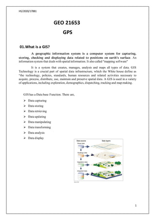
  • 1. HS/2020/17881 1 GEO 21653 GPS 01.What is a GIS? A geographic information system is a computer system for capturing, storing, checking and displaying data related to positions on earth’s surface. An information system that deals with spatial information. It also called "mapping software" It is a system that creates, manages, analysis and maps all types of data. GIS Technology is a crucial part of spatial data infrastructure, which the White house define as “the technology, policies, standards, human resources and related activities necessary to acquire, process, distribute, use, maintain and preserve spatial data. A GIS is used in a variety of applications, including exploration, demographics, dispatching, tracking and map making. GIS has a Data base Function. There are, ➢ Data capturing ➢ Data storing ➢ Data retrieving ➢ Data updating ➢ Data manipulating ➢ Data transforming ➢ Data analysis ➢ Data display
  • 2. HS/2020/17881 2 Compenets of GIS Data Users SOFTWARE Hardware Components of GIS 02.Why useful Georeferencing? Georeferencing is the process of taking a digital image, it could be an air photo, scanned geologic map or a picture of a picture of a topographic map and adding geographic information to the image so that GIS can place the image in its appropriate real-world location. It is crucial to make aerial and satellite imagery, usually raster images ,useful for mapping as it explain how other data such as the above GPS points ,relate to the imagery. Very essential information may be contained in data or images that were produced at a different point of time. Georeferencing in the digital file allows basic map analysis to be done, such as pointing and clicking on the map to determine the coordinates of appoint to calculate distances and areas and to determine other information . Once a feature has been georeferenced, it can be used in spatial analysis and mapping application. This process can be used to improve the accuracy of digital maps or make existing maps compatible with new data. It also mean using a map and referencing it via GPS or other sources of position information and then recording the values of these coordinates to a database. 03.How GPS system work? The Global Positioning System (GPS) is a satellite constellation supporting highly accurate positioning, navigation and timing measurements worldwide. As one of the first satellite positioning systems, GPS has become integral to work done worldwide, For examples, Precision agriculture, autonomous vehicles, marine or aerial surveying and define applications. It is a satellite based system consisting of a minimum of 24 satellites. It works 24*7 across the global regardless of the weather conditions. There is
  • 3. HS/2020/17881 3 also not set up charges for use it. GPS also often used to describe the positioning system itself for our lives. GPS includes three main segments: • Space segment(satellite) – They serve like stars in the constellation. • Control segment (Ground station) -They monitor and control satellites. • User segment -Receivers are constantly listening for signals from the satellite. Doppler effect is the fundamental principle used in GPS ,Changes in signal frequency from the GPS satellites it helps determining to location and speed. Any instant of time, there are at least 4 GPS satellites in line of sight to a receiver on the earth. Each of these GPS satellites sends to information about its position and the current time to the GPS receiver at fixed regular instants of time. This information is transmitted to the receiver in the form of signal which is then intercepted by the receiver to devices. These signals are radio signals that travel with the speed of light. The distance between a GPS receiver and the satellite is calculated by finding the difference between the time the signal was sent from GPS satellite and the time the GPS receiver received for the signal. Once the receiver receives the signal from at least three satellites, the receiver then points its location using trilateration process. A GPS requires at least 3 satellites to calculate 2-D position (latitude and longitude on a map).
  • 5. HS/2020/17881 5 04.Make your area of interest using google earth?
  • 6. HS/2020/17881 6 05.Do georeferencing to above area of interesting using QGIS?
  • 7. HS/2020/17881 7 06.Add at least another adjacent 3 images above map. Map 01 Map 02
  • 8. HS/2020/17881 8 Map 03 07.Why GPS want to prepare GIS Map? Because GIS is a computer system designed to capture, store, manipulate, analysis manage and present a variety of spatial and geographical data. This computer system is very important especially when it comes to planning . It has been used in variety of industries to help in planning and monitoring. ❖ It is used in planning, collecting, analysing, and stringing the complex network designs that are needed to come up with a working architecture in the field of telecom. ❖ GIS plays an important role in the environmental impact analysis process. ❖ Urban planning is one of the importance of a GIS .it can be analysing the urban growth and direction during expansion. ❖ GIS helps to analysis environmental impact process. ❖ It can be used to plan what crops needs to be grown in what areas of the farm depending on the soil structure and soil composition. ❖ The data can provide insights that can help inform the planning of the community land based on the need of the community.
  • 9. HS/2020/17881 9 ❖ GIS can also provide important data that can be used for important data that can be use regional planning. ❖ GIS is instrumental in providing information on space utilization. 08. What are the raster and vector? RASTER o In its simplest form a raster consists of matrix of cells organized into rows and columns where each cell contains a value representing information ,such as temperature. These are the types of images that are produced when scanning or photographing an object. VECTOR o Vector graphics are computer images created using a sequence of commands of mathematical statements that place lines and shape in a two dimensional or three dimensional space.  A graphic artist’s workor file is createdhadsaved as a sequence of vector statements