
Recommended
Recommended
More Related Content
What's hot
What's hot (20)
Similar to High Definition Mapping of City Streets with Mobile Mapping System
Similar to High Definition Mapping of City Streets with Mobile Mapping System (20)
Recently uploaded
Recently uploaded (20)
High Definition Mapping of City Streets with Mobile Mapping System
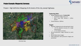
- 1. Project: High definition Mapping of all streets of the city, except highways. Target: • Matched, registered and colorized point cloud • ± 20 cm absolute accuracy of a single measurement • ± 2 cm relative accuracy • Blurred panoramic image matched on point cloud • Blurred Back-down images • Orbit publication with panoramic images and pointcloud Capturing data: • Mobile Mapping System: Trimble MX9 • panoramic images every 3 m • point cloud with density 1 million pts/sec • Overall distance: 1200 km Overview map www.datadev-ds.com Project Example: Wuppertal, Germany
- 2. Building Corner Before Matching Building CornerAfter Matching Point cloud before and after matching www.datadev-ds.com Position of control point before georeferencing Position of control point after georeferencing Matched, registered and colorized point cloud Project Example: Wuppertal, Germany
- 3. Project Example: Wuppertal, Germany www.datadev-ds.com Matched, registered and colorized point cloud
- 4. Orbit publication with matched panoramic images on pointcloud Manual mesurments • 3D coordinates extraction • length and height • angle • distance • area • volume www.datadev-ds.com Project Example: Wuppertal, Germany