More Related Content
Similar to TGS Deepwater Borehole Data Atlas
Similar to TGS Deepwater Borehole Data Atlas (20)
TGS Deepwater Borehole Data Atlas
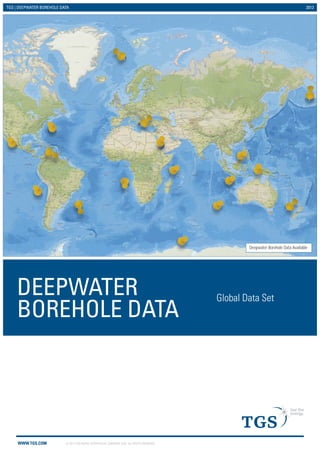
- 1. TGS | DEEPWATER BOREHOLE DATA 2013
DEEPWATER
BOREHOLE DATA Global Data Set
WWW.TGS.COM © 2013 TGS-NOPEC GEOPHYSICAL COMPANY ASA. ALL RIGHTS RESERVED.
Deepwater Borehole Data Available
- 2. TGS | DEEPWATER BOREHOLE DATA 2013
TGS - DEEPWATER BOREHOLE DATA ATLAS
This product has captured published deepwater borehole
data from the Deep Sea Drilling program (DSDP), the Ocean
Drilling Program (ODP) and the Integrated Ocean Drilling
program (IODP) projects and delivered it in a time saving
user-friendly GIS based application. The current data sets
cover the following areas:
ƒƒ North Atlantic
ƒƒ West Africa
ƒƒ The Mediterranean
ƒƒ The Black Sea - Red Sea
ƒƒ East Africa and North East Indian Ocean
ƒƒ The Indian Ocean
ƒƒ South East Asia
ƒƒ Oceania
ƒƒ The Pacific Ocean
ƒƒ The Bering Sea
ƒƒ Pacific North America
ƒƒ Pacific South America
ƒƒ The Caribbean and Gulf of Mexico
ƒƒ Atlantic North America
ƒƒ South West Atlantic
ƒƒ Antarctica
Our well data experts have reviewed these data sets
and processed data for key boreholes of interest into a
consistent industry standard format. The resulting database
contains the following key information:
ƒƒ Borehole Name/Number
ƒƒ Water Depth
ƒƒ Project Total Depth
ƒƒ Age at TD
ƒƒ Leg Cored Interval
ƒƒ Core Recovered
ƒƒ Latitude
ƒƒ Longitude
ƒƒ General Lithology
ƒƒ Reports and Analysis
ƒƒ Water Depth
WWW.TGS.COM © 2012 TGS-NOPEC GEOPHYSICAL COMPANY ASA. ALL RIGHTS RESERVED.
Where digital log data exits the curves have been quality
controlled, depth-matched, merged and corrected to
produce a consistent data set in standard LAS format.
For each borehole of interest (nominally those with
rock sequences of Pliocene or older) a composite log
style plot has been prepared comprising the following,
where available:
ƒƒ All standard open hole logs (GR, Density, Resistivity,
Sonic, Caliper etc.)
ƒƒ A lithology column constructed from available
core descriptions
ƒƒ Stratigraphic column taken from the palaeo reports
ƒƒ Geochemical analysis, especially any hydrocarbon
indicator, Rock EVAL etc.
ƒƒ Depositional environment
ƒƒ Other relevant information taken from the
published reports
- 3. TGS | DEEPWATER BOREHOLE DATA 2013
GLOBAL DATA SET
Project Wells with Wireline Log Data
Project Wells
DSDP/ ODP/ IODP Project Wells - North Atlantic
This well data package comprises 194 boreholes in an area
north of 40 degrees latitude between 13 to -65 degrees
west longitude (i.e. North of the Liberian Peninsula and
between Eastern Canada and Norway).
The West Africa Data set
WWW.TGS.COM © 2012 TGS-NOPEC GEOPHYSICAL COMPANY ASA. ALL RIGHTS RESERVED.
All of these boreholes have been cored and 30 of them have
been logged.
TGS has generated composite log panel displays for 146
boreholes that have penetrated Pliocene or older sediments.
The North Atlantic Data set
This well data package comprises 194 boreholes in an
area south of the Iberian Peninsula between the West
African coast and the mid-Atlantic ridge. All of these
boreholes have been cored and 24 of them have
been logged.
TGS has generated composite log panel displays for
152 boreholes that have penetrated Pliocene or older
sediments.
Project Wells with Wireline Log Data
Project Wells
DSDP/ ODP/ IODP Project Wells - West Africa
- 4. TGS | DEEPWATER BOREHOLE DATA 2013
GLOBAL DATA SET
Project Wells with Wireline Log Data
Project Wells
DSDP/ ODP/ IODP Project Wells - Mediterranean Sea
This well data package comprises 113 boreholes drilled in
the Mediterranean Sea. All of these boreholes have been
cored and 16 of them have been logged.
WWW.TGS.COM © 2012 TGS-NOPEC GEOPHYSICAL COMPANY ASA. ALL RIGHTS RESERVED.
TGS has generated composite log panel displays
for 73 boreholes that have penetrated Pliocene or
older sediments.
The Mediterranean Sea Data set
The Black Sea - Red Sea Data set
‘This well data package comprises 4 boreholes whose
data can be purchased individually.
3 cored wells are available in the Red Sea and 1 cored
well is available for the Black Sea.
TGS has generated composite log panel displays for
all boreholes that have penetrated Pliocene or older
sediments. The composite log panel displays (see
example) contain, where available, lithology, stratigraphy,
wireline logs, geochemistry and depositional environment.
The product is delivered as a GIS project with a personal
geodatabase that contains links to composite log images,
data tables and the IODP wellbore data.
Project Wells with Wireline Log Data
Project Wells
DSDP/ ODP/ IODP Project Wells - Black Sea - Red Sea
- 5. TGS | DEEPWATER BOREHOLE DATA 2013
GLOBAL DATA SET
Project Wells with Wireline Log Data
Project Wells
Project Wells with Wireline Log Data
Project Wells
WWW.TGS.COM © 2012 TGS-NOPEC GEOPHYSICAL COMPANY ASA. ALL RIGHTS RESERVED.
The East Africa and North
East Indian Ocean Data set
This well data package comprises 67
boreholes in an area extending from
the east coast of Africa to the eastern
boundary of the Indian plate and the
Eurasian Plate. To the southeast and
the south the area is defined by its
plate boundaries with the Australian
and Antarctic Plates respectively. All of
these boreholes have been cored and
seven of them have been logged.
TGS has generated composite log panel
displays for 52 boreholes that have
penetrated Pliocene or older sediments.
DSDP/ ODP/ IODP Project Wells - East Africa and North East Indian Ocean
The Indian Ocean Data set
This well data package comprises 33
boreholes in an area of open water to
the southwest of Sumatra.
All of these boreholes have been cored
and 4 of them have been logged.
TGS has generated composite log panel
displays for 31 boreholes that have
penetrated Pliocene or older sediments.
DSDP/ ODP/ IODP Project Wells - Indian Ocean
The South East Asia Data set
The Southeast Asia data set covers
an area encompassing the South
China Sea along with the Sulu and
Celebes Seas off the western shoreline
of the Philippines.
This well data package comprises
38 boreholes. All of these boreholes
have been cored and 5 of them have
been logged.
TGS has generated composite log
panel displays for 20 qualifying
boreholes that have penetrated Pliocene
or older sediments.
DSDP/ ODP/ IODP Project Wells - South East Asia
Project Wells with Wireline Log Data
Project Wells
- 6. TGS | DEEPWATER BOREHOLE DATA 2013
GLOBAL DATA SET
Project Wells with Wireline Log Data
Project Wells
WWW.TGS.COM © 2012 TGS-NOPEC GEOPHYSICAL COMPANY ASA. ALL RIGHTS RESERVED.
The Pacific Ocean Data set
The Bering Sea Data set
This well data package comprises 40
boreholes in an area within the Bering
Sea stretching along the chain of
Aleutian Islands. All of these boreholes
have been cored and 4 of them have
been logged.
TGS has generated composite log panel
displays for 24 boreholes that have
penetrated Pliocene or older sediments.
DSDP/ ODP/ IODP Project Wells - Bering Sea
This well data package comprises 283
boreholes surrounding the Australian
landmass and extends eastwards to the
Solomon Islands in the north east and
New Zealand to the south east.
All of these boreholes have been cored
and 54 of them have been logged.
TGS has generated composite log panel
displays for 198 boreholes that have
penetrated Pliocene or older sediments.
DSDP/ ODP/ IODP Project Wells - Oceania
The Oceania Data set
Project Wells with Wireline Log Data
Project Wells
The Pacific Ocean data set comprises of
402 boreholes in an area spread across
the open ocean.
All of these boreholes have been cored
and 63 of them have been logged.
TGS has generated composite log panel
displays for all boreholes that have
penetrated Pliocene or older sediments.
DSDP/ ODP/ IODP Project Wells - Pacific Ocean
Project Wells with Wireline Log Data
Project Wells
- 7. TGS | DEEPWATER BOREHOLE DATA 2013
GLOBAL DATA SET
The Pacific North America Data set
The Pacific North America region stretches from Alaska to
Guatemala and extends 700 km offshore.
This well data package comprises 238 boreholes. All of
these boreholes have been cored and 49 of them have
been logged.
TGS has generated composite log panel displays
for 96 boreholes that have penetrated Pliocene or
older sediments.
The Pacific South America Data set
The Pacific South America region stretches from
Costa Rica to the southern tip of Peru and extends
1,300 km offshore.
This well data package comprises 134 boreholes. All of
these boreholes have been cored and 33 of them have
been logged.
TGS has generated composite log panel displays for
85 boreholes that have penetrated Pliocene or older
sediments.
Project Wells with Wireline Log Data
Project Wells
DSDP/ ODP/ IODP Project Wells - Caribbean Sea and Gulf of Mexico
WWW.TGS.COM © 2012 TGS-NOPEC GEOPHYSICAL COMPANY ASA. ALL RIGHTS RESERVED.
Project Wells with Wireline Log Data
Project Wells
Project Wells with Wireline Log Data
Project Wells
DSDP/ ODP/ IODP Project Wells - Pacific South America
This well data package comprises 84 boreholes in an area
covering both the Caribbean Sea and the Gulf of Mexico.
All of these boreholes have been cored and 14 of them
have been logged.
TGS has generated composite log panel displays
for 42 boreholes that have penetrated Pliocene or
older sediments.
The Caribbean Sea and Gulf of Mexico Data set
DSDP/ ODP/ IODP Project Wells - Pacific North America
- 8. TGS | DEEPWATER BOREHOLE DATA 2013
GLOBAL DATA SET
The Atlantic North America Data set
The South West Atlantic Data set
This well data package comprises 147 boreholes in an
area extending eastwards from the South American
coastline to the mid-oceanic ridge plate boundary with
the African Plate. To the north the boundary is defined by
the Caribbean and North American plate boundaries.
The southern border for the data set is defined by the
plate boundary with the Antarctic plate. All of these
boreholes have been cored and 25 of them have
been logged.
TGS has generated composite log panel displays for
86 boreholes that have penetrated Pliocence or older
sediments.
The Antarctica Data set
For more information, contact TGS at:
UK
Tel: +44 (0) 208 339 4200
Email: WellData@tgs.com
US
Tel: +1 713 860 2100
Email: WellData@tgs.com
WWW.TGS.COM © 2012 TGS-NOPEC GEOPHYSICAL COMPANY ASA. ALL RIGHTS RESERVED.
DSDP/ ODP/ IODP Project Wells - South West Atlantic
Project Wells with Wireline Log Data
Project Wells
This well data package comprises 198 boreholes in an
area south of 40°N and extending eastwards from the
coastline of the United States of America to the mid-oceanic
ridge plate boundary with the African Plate. The
southern border for the data set is defined by the plate
boundary with the South American Plate.
All of these boreholes have been cored and 27 of them
have been logged.
TGS has generated composite log panel displays for 121
boreholes that have penetrated Pliocene or
older sediments.
DSDP/ ODP/ IODP Project Wells - Atlantic North America
Project Wells with Wireline Log Data
Project Wells
This well data package comprises 81 boreholes
surrounding the Antarctic landmass. All of these boreholes
have been cored and 17 of them have been logged.
TGS has generated composite log panel displays
for all boreholes that have penetrated Pliocene or
older sediments.
Project Wells with Wireline Log Data
Project Wells
DSDP/ ODP/ IODP Project Wells - Antarctica