
Recommended
More Related Content
What's hot
What's hot (20)
Similar to Low-Density Township Master Plan for Indore Development Authority
Similar to Low-Density Township Master Plan for Indore Development Authority (20)
More from Mahak Gupta
Recently uploaded
Recently uploaded (20)
Low-Density Township Master Plan for Indore Development Authority
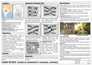
- 1. Materials Sheet No 1 SignMahak Gupta 14 arch 014 B.arch 3 Year A.C.A, Agra Date 10/02/17 •Address- 6km from the centre of Indore city, M.P. •Client- Indore Development Authority •Principal Architect - Balkrishna Doshi •Total Land area- 220 acres •Total Built-up Area- 100,000 m2 •Number of plots- 6500 •Population (projected)- 40,000 (initial) persons , 65,000 (final) person • Create a township with a sense of continuity and fundamental values of security in a good living environment. •Achieve a community character by establishing harmony between the built environment and the people. •Create a balanced community of various socio-economic groups to evolve a framework through design. •To provide serviced sites for new housing developments instead of building complete houses. Objectives Evolution of Master Plan Plan proposed by IDA without any concern for open space hierarchy, circulation system. Initial stage of proposed plan with distributed open spaces and street hierarchies. Later with rectified orientation to minimize heat gain and increase natural shading. Proposed master plan with interlinked open spaces, and climate friendly orientation. •Urban Indore city 214 sq. km. Major development along Delhi Mumbai highway running through the city in the north south direction • Site selection criteria: Linkages to the city, Employment generating industrial areas in the surroundings. Site Analysis Existing features: 1.85 hectares allotted for existing light industries. Geographical features: Flat site . A natural water channel running diagonally across the SW corner. • Top strata of the black cotton soil 2-2.5 m thick. Gradually sloping (Gradient : 1:110 approx.) towards the north-west corner. Earth and Climate •The major climatic factors affecting the nature of built form are solar radiation, ambient temperature, relative humidity, prevailing wind and rainfall. •The overall climate of Indore can be termed as composite. Inferences - • Most of the plots were small in and size and the houses were clustered in low rise blocks. • The longer side facade is oriented in the north- south axis to reduce the solar radiations on building especially during summers. • The two openings on north and south permit natural light and cross ventilation. • Courtyards within houses, cul-de-sacs, public squares and small activity areas are sufficiently shaded by the adjacent buildings. • Landscaping and green areas include flowering and shade giving trees with thick green ground cover. FLAT SITE SLOPING N-W CORNER CASE STUDY (ARANYA COMMUNITY HOUSING, INDORE) Envisaged built form- Essentially a low rise high density development the built form echoes the traditional fabric with continuity of built edge, shared walls, favorable micro climate, house form variations and culturally appropriate settings. Material like brick or stone, black cotton soil, that were locally available Concept The idea was to mix some middle income plots with EWS plots to use the profits to raise capital towards development of local trades. Location
- 2. CASE STUDY (ARANYA COMMUNITY HOUSING, INDORE) Sheet No 2 SignMahak Gupta 14 arch 014 B.arch 3 Year A.C.A, Agra Date 10/03/17 • The master plan was divided into six sectors with a central spine area of commercial and institutional land use. • The town centre in the middle part of the spine consisted of four clusters of shopping, residential and office complexes. •At the end of the spine, two more clusters of social functions were located. This was a mixed-use zone with a five storey building. • The high income group (HIG 9 per cent), is along the periphery of the national highway and part on the south east border of the arterial road in the south. • The middle income group (MIG 14 %) is planned along the periphery of arterial roads on north – west side and part on the south arterial road along the part of the spine. • The lower income group (LIG 11%)and the economically weaker sector (EWS 65%) are located in the middle of all six sectors. Hierarchy of Roads & distribution of amenity residential 60% pedestrian 25% open space 8% commercial facility 7% Other 15% SPACE USE Land Use Distribution Residential : 58 % Pedestrian : 24% Open spaces : 7% Commercial : 8% Basic Planning Layout •A house plan included two rooms and a living area followed by a kitchen . • Lavatory was constructed between the front extension and the multi use courtyard at the back. • Most houses were provided with an additional access at the back, which allowed for keeping animals, a vehicle or even renting out part of the house to provide income. • For interaction of families an otta (an important feature of the Indian home) was provided between the service spaces and the cul-de-sac. •A service core was provided with the prime objective that the basic house when completed will be sensitive to the lifestyle and daily needs of individuals with the freedom to integrate indoor and outdoor spaces with privacy within and from outside the homes, by designing optional plan. Area Calculations OTTA SPACE FOR INTERACTION STAIRS &BALCONY Housing Categories
- 3. Sheet No 3 SignMahak Gupta 14 arch 014 B.arch 3 Year A.C.A, Agra Date 10/03/17 House Plan And Elevation GROUND FLOOR PLAN (1:200) NORTH SIDE ELEVATION (1:200) SOUTH SIDE ELEVATION (1:200) STREET VIEW VIEWS CASE STUDY (ARANYA COMMUNITY HOUSING, INDORE) • In this scheme services like water tap, toilets and street lights and a plinth are provided around which houses can have different configurations. •Longer side of a block of row house was oriented north south to reduce solar radiation Provision of vertical expansions. •Structural members: Reinforced concrete plinth beams, load bearing brick walls, reinforced concrete slabs. •Exterior finishes: Bright colour in the façade, railing, grills and cornices seen in the old houses of Indore used in some houses in the township. Service •Each family provided with a plot having a water tank, sewerage connection, paved access with street lighting, storm water drainage • Service cores - key to this site and service scheme.-nuclei around which houses were built. • Septic tank provided for every 2 clusters. Water drawn from 3 local reservoirs. •To economize, 20 toilets are connected to 1 manhole.One service line serves four rows of houses Conclusion • Community facilities grouped in local sub centers. Formal organization •Community facilities distributed evenly. Accessibility improved. •Lower level Community facilities organized in green spaces . •The road network, designed according to the topography, allowed for smooth gravitational flow of water. Master Plan