Discharge and Sediment Transport Modeling Buck Creek Proposal
2016Fall_GSFC_NorthCarolinaWater_Poster_FD
1. Utilizing NASA Earth Observations and Hydrological
Modeling to Monitor Nutrient Levels in Jordan Lake, North
Carolina for Improved Water Quality Management
NorthCarolinaWaterResources
Dr. Josh Weiss, Water Resources Engineer, Hazen and Sawyer, P.C.
Dr. Amita Mehta, NASA GSFC-UMBC (Science Advisor)
Dr. Prasad Daggupati, University of Guelph
This material is based upon work supported by NASA through contract NNL11AA00B and cooperative agreement NNX14AB60A. Any mention of a
commercial product, service, or activity in this material does not constitute NASA endorsement. Any opinions, findings, and conclusions or recommendations
expressed in this material are those of the author(s) and do not necessarily reflect the views of the National Aeronautics and Space Administration and partner
organizations.
B. Everett Jordan Lake reservoir, located in Chatham County, North Carolina,
provides drinking water for approximately 250,000 people in the state. Since 1974,
the same year construction of the reservoir was completed, excessive nutrient levels
from wastewater treatment plants and agricultural runoff has led to eutrophic and
hyper-eutrophic conditions in the reservoir. As a result, the lake was determined to
have Nutrient-Sensitive Waters (NSW) and declared “impaired” by the North
Carolina Environmental Management Commission. The Jordan Lake Nutrient
Management Strategy was established to improve water quality. Monitoring of water
quality is performed by the United States Geologic Survey (USGS) at six sampling
sites on a bi-monthly basis in order to guide management and policy decisions.
However, more frequent data collection would allow regulators to better understand
how nutrient levels and management policies affect the lake. A GIS-based tool was
developed to monitor nitrogen and phosphorus levels in Jordan Lake using Earth
observations, ancillary data sources, and in situ data. The Soil & Water Assessment
Tool (SWAT) was calibrated and validated for Jordan Lake using ArcSWAT. The
results obtained from this study are the first to utilize Earth observations when
modeling water quality using SWAT in the study area, and provide near-real time
monitoring of nutrient levels, both spatially and temporally, for improved water
management.
Abstract Objectives
Methodology
Study Area
Results
Conclusions
Acknowledgements
Project Partners
Team Members
Earth Observations
NASA Goddard Space Flight Center – Fall 2016
Validate Model
with different
time period
Simulated N
and P Data
Validation
Calibrated
SWAT Model
End-User
Decision
Support
TRMM
(Tropical
Rainfall
Measuring
Mission)
Ancillary
Datasets
Format Data
for SWAT Input
GPM (Global
Precipitation
Measurement)
Run SWAT
Model
Simulated
N and P Values
Compare with
In situ N and P
values
Adjust
Parameters
(Manual
Calibration)
Calibration
Tammy Ashraf
Team Lead
Elisa Ahern Jessica Fayne
John Fitz Sara Lubkin Sean McCartney
GPM
TRMM
CALIBRATE SWAT model using Earth observations to generate simulated flow,
nitrogen, and phosphorus values for Jordan Lake
VALIDATE SWAT model output
PROVIDE DECISION SUPPORT to end-user for water quality management
by providing nitrogen and phosphorus data
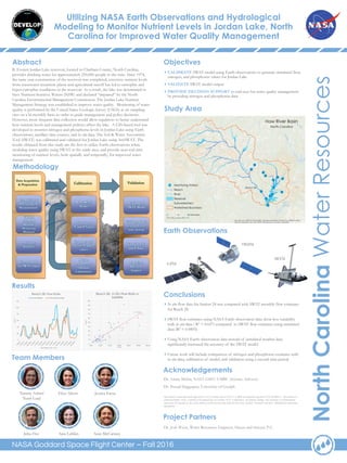
In situ flow data for Station 24 was compared with SWAT monthly flow estimates
for Reach 28.
SWAT flow estimates using NASA Earth observation data show less variability
with in situ data ( R2 = 0.657) compared to SWAT flow estimates using simulated
data (R2 = 0.0895).
Using NASA Earth observation data instead of simulated weather data
significantly increased the accuracy of the SWAT model.
Future work will include comparison of nitrogen and phosphorus estimates with
in situ data, calibration of model, and validation using a second time period.
SRTM
0
20
40
60
80
100
120
(M3/S)
TIME PERIOD: 2011-2014
Reach 28: Flow Rate
FLOW (Satellite) In Situ Monthly Average
R² = 0.657
0
10
20
30
40
50
60
70
80
90
100
0.00 20.00 40.00 60.00 80.00 100.00 120.00
(m3/s)
(m3/s)
Reach 28: In Situ Flow Rate vs
Satellite