Modeling the hydrological regime of Turkana Lake (Kenya, Ethiopia) by combining spatially distributed hydrological model and remote sensing datasets
•
1 like•1,131 views

DAFNE poster presented at the 2017 AGU Fall Meeting
Recommended

Recommended
More Related Content
What's hot
What's hot (20)
Similar to Modeling the hydrological regime of Turkana Lake (Kenya, Ethiopia) by combining spatially distributed hydrological model and remote sensing datasets
Similar to Modeling the hydrological regime of Turkana Lake (Kenya, Ethiopia) by combining spatially distributed hydrological model and remote sensing datasets (20)
More from DAFNE project
More from DAFNE project (13)
Recently uploaded
Recently uploaded (20)
Modeling the hydrological regime of Turkana Lake (Kenya, Ethiopia) by combining spatially distributed hydrological model and remote sensing datasets
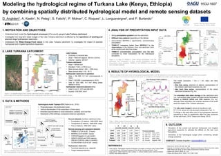
- 1. a) b) d) c) Gibe I Gibe III a) b) d) e) c) The model (resolution: 1 km x 1 km, daily) can fairly represent: • flow time series observed at stations representative of the northern catchment dynamics (Fig. 4b); • lake level time series, representative of the whole catchment dynamics (Fig. 4c) The lake water budget is almost at equilibrium with ET = P+Q, where Q is the dominant component (Tab. 1). A change in the total inflow due to the hydropower reservoir operations is likely to significantly affect the lake dynamics (in line with Avery, 2010, Velpuri and Senay, 2012). The simulated total water storage at the catchment level (i.e., sub-surface water content and lake) shows fluctuations similar to GRACE GRGS and CRS mascon (Fig. 4d), although these estimates are uncertain because of the small area and shape of the Turkana catchment. HYDROLOGICAL MODEL TOPKAPI-ETH DEM Soil Land cover ANALYSIS OF INPUT DATA TRMM-V7 precipitation MERRA-2 temperature MERRA-2 cloud cover Precipitation Temperature Streamflow ANALYSIS OF HYDROLOGICAL MODEL RESULTS Lake level GRACE total water storage GLDAS-NOAH 2m soil moisture Streamflow TOPEX/Poseidon satellite altimetry data Precipitation Reservoir operations 1st sub-surf. layer 2nd sub-surf. layer Groundwater layer Evapotranspiration Flow from/to adjacent layer/cell Groundwater Soil moisture a) b) 1. MOTIVATION AND OBJECTIVES REFERENCES • Understand and model the hydrological processes of the poorly gauged Lake Turkana catchment. • Investigate how long-term water budget of the Lake Turkana catchment is affected by the operations of existing and planned large hydropower reservoirs. • Understand the Water-Energy-Food nexus in the Lake Turkana catchment, to investigate the impact of planned hydropower and irrigated agriculture expansion. Modeling the hydrological regime of Turkana Lake (Kenya, Ethiopia) by combining spatially distributed hydrological model and remote sensing datasets H53J-1607 D. Anghileri1, A. Kaelin1, N. Peleg1, S. Fatichi1, P. Molnar1, C. Roques1, L. Longuevergne2, and P. Burlando1 1 ETH Zurich; 2 CNRS 3. DATA & METHODS Ground datasets (northern catchment only): • Precipitation (14 stations, 1998-2008, daily) • Temperature (6 stations, 1998-2008, daily) • Flow (3 stations, 1998-2007, daily) Remote sensing and reanalysis datasets: • TRMM-V7 (0.25°x0.25°, 3 hours) • MERRA-2 (0.5°x0.625°, hourly) • TOPEX/Poseidon (≈1 per month) • GRACE (GRGS and CRS mascon) (300 km X 300 km, daily or monthly) • GLDAS-NOAH (0.25°x0.25°, hourly) Hydropower reservoirs: • Technical features (e.g., capacity) • Target release/production Funded under the H2020 Framework Program of the EU, GA No. 690268 Hydrological model Topkapi-ETH (Fatichi et al., 2015): • Physically-based, fully distributed model • Vertical discretization of the subsurface in three layers • Kinematic approximation to route subsurface, overland, and river flow • Description of the anthropic component (reservoir operations) Lake Turkana: • Endorheic or terminal lake • Area = 7’500 km2 (approx. 240 km x 30 km) • Volume = approx. 200 km3 Turkana catchment: • Area = 148’000 km2 • Elevation = 320 – 2’700 m a.s.l. • Mean annual precip.= 250 – 1’800 mm/y • Mean annual temp.= 14 – 30 °C Hydropower reservoirs in operation: • Gibe I: 184 MW, 0.7 km3 (commissioned in 2004) • Gibe II: 420 MW, (commissioned in 2010) • Gibe III: 1870 MW, 14.7 km3 (filling phase started in 2016) Hydropower reservoirs planned either: • Gibe IV and V: 1472 and 560 MW • Koysha: 2160 MW, 6 km3 5. RESULTS OF HYDROLOGICAL MODEL • Strong precipitation gradient over the catchment. • Different rainy patterns depending on the latitude. • Uncorrected MERRA-2 significantly overestimates precipitation. • TRMM-V7 compares better than MERRA-2 to the observations in the Northern Omo sub-catchment (both at the monthly and daily time scale). • TRMM-V7 overestimates precipitation over the lake (corrected by linear interpolation for the hydrological simulation) Figure 3: a) Map of TRMM-V7 mean annual precipitation over the catchment; b-e) Comparison of mean monthly precipitation between observations (when available), TRMM-V7, and MERRA-2 (uncorrected and corrected) datasets. Figure 2: Modeling framework: ground, remote sensing, and reanalysis datasets and schematization of the hydrological processes modeled in Topkapi-ETH (for one grid cell). Figure 1: a) Satellite image of the Turkana catchment (source: Google map), and b) map of the catchment including the lake, hydropower reservoirs, major rivers, and available gauges . 2. LAKE TURKANA CATCHMENT P (mm/d) ET (mm/d) Q (mm/d) Q (m3/s) Land 2.85 2.44 0.37 634 (2) Lake 0.87 8.32 (1) 7.30 634 (2) Omo 3.86 3.19 0.67 562 (3) Kerio 1.75 1.62 0.18 35 (4) Turkwel 1.94 1.81 0.14 37 (5) Previous estimates (1) 7.6 mm/d Avery, 2010 (2) 650 m3/s Velpuri, 2012 (3) 555 m3/s Avery, 2013 (4) 5 m3/s Avery, 2010 (5) 26 m3/s Sogreah, 1982 Figure 4: a) Map of simulated mean annual actual evapotranspiration over the catchment; b) Comparison of daily simulated and observed flow at Abelti; c) Comparison of simulated and observed lake level; d) Comparison of simulated sub-surface water storage and GRACE datasets. Table 1: Water budget components over the whole catchment (without the lake), lake, and sub-basins of major lake tributaries. 6. OUTLOOK • Simulation of the current and planned hydropower and irrigated agriculture expansion to estimate the effects on the lake level fluctuations. • Simulation of the hydrological budget when considering climate change scenarios. CONTACT: Daniela Anghileri | adaniela@ethz.ch 4. ANALYSIS OF PRECIPITATION INPUT DATA • Avery (2010). “Hydrological Impacts of Ethiopia’s Omo Basin on Kenya’s Lake Turkana Water Levels & Fisheries. Final report prepared for the African Development Bank, Tunis.” • Avery (2013). “What Future For Lake Turkana”. In: African Studies Centre, Oxford University. • DAFNE: http://dafne-project.eu/ • Fatichi et al. (2015), JoH 525, 362–382. • Sogreah, Consulting Engineers (1982). “Regional Development Plan for the Kerio Valley, Water Resources Study, for Kerio Valley Development Authority, Kenya”. • Velpuri et al. (2012). HESS, 16, 1-18. • Velpuri and Senay (2012). HESS, 16.10, 3561–3578.