SlideShare a Scribd company logo
1 of 17
Download to read offline
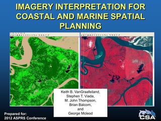
IMAGERY INTERPRETATION FOR
COASTAL AND MARINE SPATIAL
PLANNING
Prepared for:
2012 ASPRS Conference
Keith B. VanGraafeiland,
Stephen T. Viada,
M. John Thompson,
Brian Balcom,
and
George Mcleod
Acknowledgments
Anadarko Petroleum Corporation (APC)
• John Peffer
• Mario Rassul
• Karina Pena
Purpose
• Remote Sensing Data
– satellite imagery
– side-scan sonar
• GIS habitat mapping
– Imagery classification
– Imagery interpretation
• Environmental sensitivity analysis methods
– Identify features and areas of concern for
avoidance and to minimize environmental impacts
• These data can be used to produce:
– Environmental Sensitivity Index (ESI) maps,
– thematic maps, and
– statistical summaries (areal and linear
dimensions) of habitat type
• Support:
– Environmental Impact Assessments (EIAs),
– Environmental Impact Studies (EISs),
– Baseline Environmental Baseline Surveys (EBSs),
– monitoring plans, and
– Spill contingency planning.
CASE STUDY
Northern Mozambique,
Africa
• A 2D and 3D geophysical
survey program was
proposed within shallow
waters of the Quirimbas
Archipelago, Mozambique
Study purpose:
• Locate seafloor features
warranting environmental
protection from seismic
operations
• Develop a mitigation plan to
minimize potential
environmental impact
Study Objectives
1. Characterize and map marine habitats
2. Identify physical areas of concern
3. Develop a mitigation plan
4. Implement a field survey to delineate
areas of environmental concern
• Environmental Impact Assessment
(EIA), with an approved environmental
impact mitigation plan
• Environmental Management Plan
(EMP)
Characterization and Mapping of
Shallow Water Marine Habitats
• Mangrove-dominated communities
• Submerged aquatic vegetation
• Bare sand and mud substrates
• Shallow and emergent hard substrates
• Shallow and emergent coral
communities
• Deepwater coral communities
Objective 1
A set of high resolution remote sensing
(satellite imagery) tiles of the coastal and
nearshore waters of the project area were
used to create a georeferenced mosaic
Habitat categories were identified and coded as
colored polygons, creating a georeferenced
habitat map
Environmental Sensitivity Index (ESI)
methods were used to determine the
relative sensitivity of each identified
habitat category
Habitat Sensitivity Analysis
Objective 2
Sources of environmental impact included
• seismic sound pressure waves
• physical contact with receiver cables and
autonomous receivers
Potential Levels of Impact Severity
Impact Severity Consequence
Negligible
Negligible or little harm to sensitive resources, with reversible effects
Little or no environmental exposure
Minor
Low, minor environmental impact
Exposure limited to immediate site
Moderate
Medium, moderate environmental impact
Incident potentially contaminating local resources
Significant
Major environmental impact (see text below)
Environmental incident resulting in contamination of local resources
Catastrophic
Catastrophic disaster, major environmental impact
Major environmental incident causing significant regional damage to the environment
Scale of Environmental Sensitivity
1
Negligible
2
Minor
3
Moderate
4
Significant
5
Catastrophic
Severity of Impact
––––––––►
Objective 3
From the ESI results, an impact mitigation
strategy was designed to avoid or
minimize potential impacts to sensitive
marine resources and habitats
Develop a Mitigation Plan for the Protection of
the Identified Areas of Concern
Mitigation measures consisted of acoustic
exclusion zones (“buffer zones”),
considering proposed activity scenarios
Objective 4
A field survey was designed and
implemented to accurately and
efficiently identify and delineate areas
that met sensitive habitat criteria
Field Survey
Field Survey Methods
• a preliminary mapping
survey of selected segments
with digital side-scan sonar
• visual assessment
(groundtruthing) of selected
seafloor features by divers
Survey Data Analysis
Image showing sand
waves with seagrasses
and macroalgae
Image showing dense
seagrass beds
on soft substrate
Survey Data Analysis
The processed sonar
data swath was
superimposed on the
satellite mosaic for
interpretation
Each proposed seismic
survey trackline was
superimposed on the
corresponding satellite
mosaic
Survey Data Analysis
Results obtained
from
groundtruthing
selected targets
provided
supportive
information for
seafloor
interpretation
Selected
groundtruth
targets were
plotted, and areas
meeting selection
criteria were
provided a buffer
of 75 m
The final product
comprised a
color-coded
overlay of the
surveyed trackline
segment
Survey Results
• 250 line km were surveyed
• 90 km were in water depths <2 m
• 42 km were designated as sensitive habitat
• 118 km did not contain sensitive habitat or were
too deep to survey
Conclusions
• Sensitive shallow water habitats were
mapped within the project area
• Acoustic exclusion areas (buffers) for
selected resources were implemented
The methods provide a practical and
efficient means to characterize and
map seafloor habitats within large
geographic areas, and may be applied
to other activity scenarios and
geographic areas

More Related Content

What's hot

Meeting intermedio rete 3 cefalopodi eng
Meeting intermedio rete 3  cefalopodi engMeeting intermedio rete 3  cefalopodi eng
Meeting intermedio rete 3 cefalopodi engTommaso Russo
 
CCW conference: Social approaches to climate change
CCW conference: Social approaches to climate changeCCW conference: Social approaches to climate change
CCW conference: Social approaches to climate changeClean Water
 
Geomorphology applications
Geomorphology applicationsGeomorphology applications
Geomorphology applicationsvyshalik
 
Taramelli_al_IGARSS_2011.pptx
Taramelli_al_IGARSS_2011.pptxTaramelli_al_IGARSS_2011.pptx
Taramelli_al_IGARSS_2011.pptxgrssieee
 
Crete-Fieldwork-final-report print version
Crete-Fieldwork-final-report print versionCrete-Fieldwork-final-report print version
Crete-Fieldwork-final-report print versionConnor Spruce
 
Remote sensing of biological soil crusts
Remote sensing of biological soil crustsRemote sensing of biological soil crusts
Remote sensing of biological soil crustsAlex Key
 
Remote sensing as landscape inventory tool
Remote sensing as landscape inventory toolRemote sensing as landscape inventory tool
Remote sensing as landscape inventory toolCIFOR-ICRAF
 
Liddell TERN-super sites-phenology-ACEAS
Liddell TERN-super sites-phenology-ACEASLiddell TERN-super sites-phenology-ACEAS
Liddell TERN-super sites-phenology-ACEASaceas13tern
 
Heritage hetherington lidar_pdf[1]
Heritage hetherington lidar_pdf[1]Heritage hetherington lidar_pdf[1]
Heritage hetherington lidar_pdf[1]llica
 
Surface and soil moisture monitoring, estimations, variations, and retrievals
Surface and soil moisture monitoring, estimations, variations, and retrievalsSurface and soil moisture monitoring, estimations, variations, and retrievals
Surface and soil moisture monitoring, estimations, variations, and retrievalsJenkins Macedo
 
On the performance of filters for reduction of speckle noise in sar images of...
On the performance of filters for reduction of speckle noise in sar images of...On the performance of filters for reduction of speckle noise in sar images of...
On the performance of filters for reduction of speckle noise in sar images of...Zac Darcy
 
Seafloor mapping and visualisation_rev
Seafloor mapping and visualisation_revSeafloor mapping and visualisation_rev
Seafloor mapping and visualisation_revMaja Berden-Zrimec
 
Using Remote Sensing Techniques For Monitoring Ecological Changes In Lakes: C...
Using Remote Sensing Techniques For Monitoring Ecological Changes In Lakes: C...Using Remote Sensing Techniques For Monitoring Ecological Changes In Lakes: C...
Using Remote Sensing Techniques For Monitoring Ecological Changes In Lakes: C...IJERA Editor
 

What's hot (20)

Meeting intermedio rete 3 cefalopodi eng
Meeting intermedio rete 3  cefalopodi engMeeting intermedio rete 3  cefalopodi eng
Meeting intermedio rete 3 cefalopodi eng
 
Fundamentals aquatic-web
Fundamentals aquatic-webFundamentals aquatic-web
Fundamentals aquatic-web
 
CCW conference: Social approaches to climate change
CCW conference: Social approaches to climate changeCCW conference: Social approaches to climate change
CCW conference: Social approaches to climate change
 
Geomorphology applications
Geomorphology applicationsGeomorphology applications
Geomorphology applications
 
Silva&Cripps2011
Silva&Cripps2011Silva&Cripps2011
Silva&Cripps2011
 
Iirs rstechnologypdf
Iirs rstechnologypdfIirs rstechnologypdf
Iirs rstechnologypdf
 
Taramelli_al_IGARSS_2011.pptx
Taramelli_al_IGARSS_2011.pptxTaramelli_al_IGARSS_2011.pptx
Taramelli_al_IGARSS_2011.pptx
 
Crete-Fieldwork-final-report print version
Crete-Fieldwork-final-report print versionCrete-Fieldwork-final-report print version
Crete-Fieldwork-final-report print version
 
Remote sensing of biological soil crusts
Remote sensing of biological soil crustsRemote sensing of biological soil crusts
Remote sensing of biological soil crusts
 
Remote sensing as landscape inventory tool
Remote sensing as landscape inventory toolRemote sensing as landscape inventory tool
Remote sensing as landscape inventory tool
 
Liddell TERN-super sites-phenology-ACEAS
Liddell TERN-super sites-phenology-ACEASLiddell TERN-super sites-phenology-ACEAS
Liddell TERN-super sites-phenology-ACEAS
 
Chapter 1
Chapter 1 Chapter 1
Chapter 1
 
Heritage hetherington lidar_pdf[1]
Heritage hetherington lidar_pdf[1]Heritage hetherington lidar_pdf[1]
Heritage hetherington lidar_pdf[1]
 
ESA poster
ESA posterESA poster
ESA poster
 
Surface and soil moisture monitoring, estimations, variations, and retrievals
Surface and soil moisture monitoring, estimations, variations, and retrievalsSurface and soil moisture monitoring, estimations, variations, and retrievals
Surface and soil moisture monitoring, estimations, variations, and retrievals
 
On the performance of filters for reduction of speckle noise in sar images of...
On the performance of filters for reduction of speckle noise in sar images of...On the performance of filters for reduction of speckle noise in sar images of...
On the performance of filters for reduction of speckle noise in sar images of...
 
Seafloor mapping and visualisation_rev
Seafloor mapping and visualisation_revSeafloor mapping and visualisation_rev
Seafloor mapping and visualisation_rev
 
Using Remote Sensing Techniques For Monitoring Ecological Changes In Lakes: C...
Using Remote Sensing Techniques For Monitoring Ecological Changes In Lakes: C...Using Remote Sensing Techniques For Monitoring Ecological Changes In Lakes: C...
Using Remote Sensing Techniques For Monitoring Ecological Changes In Lakes: C...
 
Invention of g.r.irlapati_s_geoscope
Invention of g.r.irlapati_s_geoscopeInvention of g.r.irlapati_s_geoscope
Invention of g.r.irlapati_s_geoscope
 
Ag. agent update
Ag. agent updateAg. agent update
Ag. agent update
 

Similar to Imagery Interpretation for Coastal and Marine Spatial Planning

Mark Thomas_A digital soil mapping approach for regolith thickness in the com...
Mark Thomas_A digital soil mapping approach for regolith thickness in the com...Mark Thomas_A digital soil mapping approach for regolith thickness in the com...
Mark Thomas_A digital soil mapping approach for regolith thickness in the com...TERN Australia
 
Use of remote sensing for land cover monitoring servir science applications
Use of remote sensing for land cover monitoring servir science applicationsUse of remote sensing for land cover monitoring servir science applications
Use of remote sensing for land cover monitoring servir science applicationsKabir Uddin
 
01 - Overview of Geophysical Methods.pptx
01 - Overview of Geophysical Methods.pptx01 - Overview of Geophysical Methods.pptx
01 - Overview of Geophysical Methods.pptxAgnikulakshatriyasan
 
Multi-Spectral Analysis of Satellite Imagery for Inventory of Sensitive Marin...
Multi-Spectral Analysis of Satellite Imagery for Inventory of Sensitive Marin...Multi-Spectral Analysis of Satellite Imagery for Inventory of Sensitive Marin...
Multi-Spectral Analysis of Satellite Imagery for Inventory of Sensitive Marin...Keith VanGraafeiland
 
Application of remote sensing in coastal zone management
Application of remote sensing in coastal zone managementApplication of remote sensing in coastal zone management
Application of remote sensing in coastal zone managementMayur Tade
 
Prem Gill Seals From Space
Prem Gill Seals From SpacePrem Gill Seals From Space
Prem Gill Seals From SpacePeter Bloomfield
 
OPWALL Project Proposal 2016
OPWALL Project Proposal 2016OPWALL Project Proposal 2016
OPWALL Project Proposal 2016Kevin Schmidt
 
Remote sensing application in monitoring and management of soil, water and ai...
Remote sensing application in monitoring and management of soil, water and ai...Remote sensing application in monitoring and management of soil, water and ai...
Remote sensing application in monitoring and management of soil, water and ai...Jayvir Solanki
 
Remote Sensing Presentation
Remote Sensing PresentationRemote Sensing Presentation
Remote Sensing PresentationKamran Ahmed
 
Assessment sg detection by remote sensing
Assessment sg detection by remote sensingAssessment sg detection by remote sensing
Assessment sg detection by remote sensingFiddy Prasetiya
 
Remote sensing technology and applications
Remote  sensing technology and applicationsRemote  sensing technology and applications
Remote sensing technology and applicationsShyam Sundar Roy
 
EIA REPORT :Renuka dam project
EIA REPORT :Renuka dam project  EIA REPORT :Renuka dam project
EIA REPORT :Renuka dam project Saurabh Gupta
 
Results of the EMODnet Sea-basin Checkpoints: geology
Results of the EMODnet Sea-basin Checkpoints: geologyResults of the EMODnet Sea-basin Checkpoints: geology
Results of the EMODnet Sea-basin Checkpoints: geologyEMODnet
 
GWP - Flood Hazard Mapping for Small Island Developing States using GIS and L...
GWP - Flood Hazard Mapping for Small Island Developing States using GIS and L...GWP - Flood Hazard Mapping for Small Island Developing States using GIS and L...
GWP - Flood Hazard Mapping for Small Island Developing States using GIS and L...Esri UK
 
Ronkainen_FINMARINET_posteri_GEOHAB
Ronkainen_FINMARINET_posteri_GEOHABRonkainen_FINMARINET_posteri_GEOHAB
Ronkainen_FINMARINET_posteri_GEOHABMinna Ronkainen
 
Ian Davies - Recent experience of Cumulative Impact Assessment in renewables ...
Ian Davies - Recent experience of Cumulative Impact Assessment in renewables ...Ian Davies - Recent experience of Cumulative Impact Assessment in renewables ...
Ian Davies - Recent experience of Cumulative Impact Assessment in renewables ...andronikos1990
 
DSD-NL 2018 Evolutie in het leveren van ruimtelijke en temporele water gerela...
DSD-NL 2018 Evolutie in het leveren van ruimtelijke en temporele water gerela...DSD-NL 2018 Evolutie in het leveren van ruimtelijke en temporele water gerela...
DSD-NL 2018 Evolutie in het leveren van ruimtelijke en temporele water gerela...Deltares
 

Similar to Imagery Interpretation for Coastal and Marine Spatial Planning (20)

Mark Thomas_A digital soil mapping approach for regolith thickness in the com...
Mark Thomas_A digital soil mapping approach for regolith thickness in the com...Mark Thomas_A digital soil mapping approach for regolith thickness in the com...
Mark Thomas_A digital soil mapping approach for regolith thickness in the com...
 
Use of remote sensing for land cover monitoring servir science applications
Use of remote sensing for land cover monitoring servir science applicationsUse of remote sensing for land cover monitoring servir science applications
Use of remote sensing for land cover monitoring servir science applications
 
01 - Overview of Geophysical Methods.pptx
01 - Overview of Geophysical Methods.pptx01 - Overview of Geophysical Methods.pptx
01 - Overview of Geophysical Methods.pptx
 
MappingMangroves
MappingMangrovesMappingMangroves
MappingMangroves
 
Multi-Spectral Analysis of Satellite Imagery for Inventory of Sensitive Marin...
Multi-Spectral Analysis of Satellite Imagery for Inventory of Sensitive Marin...Multi-Spectral Analysis of Satellite Imagery for Inventory of Sensitive Marin...
Multi-Spectral Analysis of Satellite Imagery for Inventory of Sensitive Marin...
 
Application of remote sensing in coastal zone management
Application of remote sensing in coastal zone managementApplication of remote sensing in coastal zone management
Application of remote sensing in coastal zone management
 
Prem Gill Seals From Space
Prem Gill Seals From SpacePrem Gill Seals From Space
Prem Gill Seals From Space
 
OPWALL Project Proposal 2016
OPWALL Project Proposal 2016OPWALL Project Proposal 2016
OPWALL Project Proposal 2016
 
Remote sensing application in monitoring and management of soil, water and ai...
Remote sensing application in monitoring and management of soil, water and ai...Remote sensing application in monitoring and management of soil, water and ai...
Remote sensing application in monitoring and management of soil, water and ai...
 
Remote Sensing Presentation
Remote Sensing PresentationRemote Sensing Presentation
Remote Sensing Presentation
 
Data, Tools, Training, and Technical Assistance
Data, Tools, Training, and Technical AssistanceData, Tools, Training, and Technical Assistance
Data, Tools, Training, and Technical Assistance
 
Presentation: Fee & Brigley
Presentation: Fee & BrigleyPresentation: Fee & Brigley
Presentation: Fee & Brigley
 
Assessment sg detection by remote sensing
Assessment sg detection by remote sensingAssessment sg detection by remote sensing
Assessment sg detection by remote sensing
 
Remote sensing technology and applications
Remote  sensing technology and applicationsRemote  sensing technology and applications
Remote sensing technology and applications
 
EIA REPORT :Renuka dam project
EIA REPORT :Renuka dam project  EIA REPORT :Renuka dam project
EIA REPORT :Renuka dam project
 
Results of the EMODnet Sea-basin Checkpoints: geology
Results of the EMODnet Sea-basin Checkpoints: geologyResults of the EMODnet Sea-basin Checkpoints: geology
Results of the EMODnet Sea-basin Checkpoints: geology
 
GWP - Flood Hazard Mapping for Small Island Developing States using GIS and L...
GWP - Flood Hazard Mapping for Small Island Developing States using GIS and L...GWP - Flood Hazard Mapping for Small Island Developing States using GIS and L...
GWP - Flood Hazard Mapping for Small Island Developing States using GIS and L...
 
Ronkainen_FINMARINET_posteri_GEOHAB
Ronkainen_FINMARINET_posteri_GEOHABRonkainen_FINMARINET_posteri_GEOHAB
Ronkainen_FINMARINET_posteri_GEOHAB
 
Ian Davies - Recent experience of Cumulative Impact Assessment in renewables ...
Ian Davies - Recent experience of Cumulative Impact Assessment in renewables ...Ian Davies - Recent experience of Cumulative Impact Assessment in renewables ...
Ian Davies - Recent experience of Cumulative Impact Assessment in renewables ...
 
DSD-NL 2018 Evolutie in het leveren van ruimtelijke en temporele water gerela...
DSD-NL 2018 Evolutie in het leveren van ruimtelijke en temporele water gerela...DSD-NL 2018 Evolutie in het leveren van ruimtelijke en temporele water gerela...
DSD-NL 2018 Evolutie in het leveren van ruimtelijke en temporele water gerela...
 

More from Keith VanGraafeiland

Living Atlas of the World - Oceans Update
Living Atlas of the World - Oceans UpdateLiving Atlas of the World - Oceans Update
Living Atlas of the World - Oceans UpdateKeith VanGraafeiland
 
Living Atlas of the World - Oceans
Living Atlas of the World - OceansLiving Atlas of the World - Oceans
Living Atlas of the World - OceansKeith VanGraafeiland
 
Nearshore Surveying and Mapping - Alternatives
Nearshore Surveying and Mapping - AlternativesNearshore Surveying and Mapping - Alternatives
Nearshore Surveying and Mapping - AlternativesKeith VanGraafeiland
 
Creating a Unified Marine Spatial Planning and Management Environment
Creating a Unified Marine Spatial Planning and Management EnvironmentCreating a Unified Marine Spatial Planning and Management Environment
Creating a Unified Marine Spatial Planning and Management EnvironmentKeith VanGraafeiland
 
Nearshore Hardbottom Monitoring: Alternative Methods
Nearshore Hardbottom Monitoring: Alternative MethodsNearshore Hardbottom Monitoring: Alternative Methods
Nearshore Hardbottom Monitoring: Alternative MethodsKeith VanGraafeiland
 
Applied Geovisualization for Hurricane Surge Risk Awareness and Emergency Man...
Applied Geovisualization for Hurricane Surge Risk Awareness and Emergency Man...Applied Geovisualization for Hurricane Surge Risk Awareness and Emergency Man...
Applied Geovisualization for Hurricane Surge Risk Awareness and Emergency Man...Keith VanGraafeiland
 
Ground Verification using the Richo Capilo 500SE
Ground Verification using the Richo Capilo 500SEGround Verification using the Richo Capilo 500SE
Ground Verification using the Richo Capilo 500SEKeith VanGraafeiland
 

More from Keith VanGraafeiland (9)

Living Atlas of the World - Oceans Update
Living Atlas of the World - Oceans UpdateLiving Atlas of the World - Oceans Update
Living Atlas of the World - Oceans Update
 
Living Atlas of the World - Oceans
Living Atlas of the World - OceansLiving Atlas of the World - Oceans
Living Atlas of the World - Oceans
 
Leveraging the ArcGIS Platform
Leveraging the ArcGIS PlatformLeveraging the ArcGIS Platform
Leveraging the ArcGIS Platform
 
Nearshore Surveying and Mapping - Alternatives
Nearshore Surveying and Mapping - AlternativesNearshore Surveying and Mapping - Alternatives
Nearshore Surveying and Mapping - Alternatives
 
Creating a Unified Marine Spatial Planning and Management Environment
Creating a Unified Marine Spatial Planning and Management EnvironmentCreating a Unified Marine Spatial Planning and Management Environment
Creating a Unified Marine Spatial Planning and Management Environment
 
Marine Spatial Planning - FMV
Marine Spatial Planning - FMVMarine Spatial Planning - FMV
Marine Spatial Planning - FMV
 
Nearshore Hardbottom Monitoring: Alternative Methods
Nearshore Hardbottom Monitoring: Alternative MethodsNearshore Hardbottom Monitoring: Alternative Methods
Nearshore Hardbottom Monitoring: Alternative Methods
 
Applied Geovisualization for Hurricane Surge Risk Awareness and Emergency Man...
Applied Geovisualization for Hurricane Surge Risk Awareness and Emergency Man...Applied Geovisualization for Hurricane Surge Risk Awareness and Emergency Man...
Applied Geovisualization for Hurricane Surge Risk Awareness and Emergency Man...
 
Ground Verification using the Richo Capilo 500SE
Ground Verification using the Richo Capilo 500SEGround Verification using the Richo Capilo 500SE
Ground Verification using the Richo Capilo 500SE
 

Recently uploaded

Isotopic evidence of long-lived volcanism on Io
Isotopic evidence of long-lived volcanism on IoIsotopic evidence of long-lived volcanism on Io
Isotopic evidence of long-lived volcanism on IoSérgio Sacani
 
Recombinant DNA technology (Immunological screening)
Recombinant DNA technology (Immunological screening)Recombinant DNA technology (Immunological screening)
Recombinant DNA technology (Immunological screening)PraveenaKalaiselvan1
 
Zoology 4th semester series (krishna).pdf
Zoology 4th semester series (krishna).pdfZoology 4th semester series (krishna).pdf
Zoology 4th semester series (krishna).pdfSumit Kumar yadav
 
VIRUSES structure and classification ppt by Dr.Prince C P
VIRUSES structure and classification ppt by Dr.Prince C PVIRUSES structure and classification ppt by Dr.Prince C P
VIRUSES structure and classification ppt by Dr.Prince C PPRINCE C P
 
PossibleEoarcheanRecordsoftheGeomagneticFieldPreservedintheIsuaSupracrustalBe...
PossibleEoarcheanRecordsoftheGeomagneticFieldPreservedintheIsuaSupracrustalBe...PossibleEoarcheanRecordsoftheGeomagneticFieldPreservedintheIsuaSupracrustalBe...
PossibleEoarcheanRecordsoftheGeomagneticFieldPreservedintheIsuaSupracrustalBe...Sérgio Sacani
 
Raman spectroscopy.pptx M Pharm, M Sc, Advanced Spectral Analysis
Raman spectroscopy.pptx M Pharm, M Sc, Advanced Spectral AnalysisRaman spectroscopy.pptx M Pharm, M Sc, Advanced Spectral Analysis
Raman spectroscopy.pptx M Pharm, M Sc, Advanced Spectral AnalysisDiwakar Mishra
 
Discovery of an Accretion Streamer and a Slow Wide-angle Outflow around FUOri...
Discovery of an Accretion Streamer and a Slow Wide-angle Outflow around FUOri...Discovery of an Accretion Streamer and a Slow Wide-angle Outflow around FUOri...
Discovery of an Accretion Streamer and a Slow Wide-angle Outflow around FUOri...Sérgio Sacani
 
Chromatin Structure | EUCHROMATIN | HETEROCHROMATIN
Chromatin Structure | EUCHROMATIN | HETEROCHROMATINChromatin Structure | EUCHROMATIN | HETEROCHROMATIN
Chromatin Structure | EUCHROMATIN | HETEROCHROMATINsankalpkumarsahoo174
 
Botany 4th semester series (krishna).pdf
Botany 4th semester series (krishna).pdfBotany 4th semester series (krishna).pdf
Botany 4th semester series (krishna).pdfSumit Kumar yadav
 
Orientation, design and principles of polyhouse
Orientation, design and principles of polyhouseOrientation, design and principles of polyhouse
Orientation, design and principles of polyhousejana861314
 
Spermiogenesis or Spermateleosis or metamorphosis of spermatid
Spermiogenesis or Spermateleosis or metamorphosis of spermatidSpermiogenesis or Spermateleosis or metamorphosis of spermatid
Spermiogenesis or Spermateleosis or metamorphosis of spermatidSarthak Sekhar Mondal
 
Unlocking the Potential: Deep dive into ocean of Ceramic Magnets.pptx
Unlocking  the Potential: Deep dive into ocean of Ceramic Magnets.pptxUnlocking  the Potential: Deep dive into ocean of Ceramic Magnets.pptx
Unlocking the Potential: Deep dive into ocean of Ceramic Magnets.pptxanandsmhk
 
Recombination DNA Technology (Nucleic Acid Hybridization )
Recombination DNA Technology (Nucleic Acid Hybridization )Recombination DNA Technology (Nucleic Acid Hybridization )
Recombination DNA Technology (Nucleic Acid Hybridization )aarthirajkumar25
 
Lucknow 💋 Russian Call Girls Lucknow Finest Escorts Service 8923113531 Availa...
Lucknow 💋 Russian Call Girls Lucknow Finest Escorts Service 8923113531 Availa...Lucknow 💋 Russian Call Girls Lucknow Finest Escorts Service 8923113531 Availa...
Lucknow 💋 Russian Call Girls Lucknow Finest Escorts Service 8923113531 Availa...anilsa9823
 
Nightside clouds and disequilibrium chemistry on the hot Jupiter WASP-43b
Nightside clouds and disequilibrium chemistry on the hot Jupiter WASP-43bNightside clouds and disequilibrium chemistry on the hot Jupiter WASP-43b
Nightside clouds and disequilibrium chemistry on the hot Jupiter WASP-43bSérgio Sacani
 
DIFFERENCE IN BACK CROSS AND TEST CROSS
DIFFERENCE IN  BACK CROSS AND TEST CROSSDIFFERENCE IN  BACK CROSS AND TEST CROSS
DIFFERENCE IN BACK CROSS AND TEST CROSSLeenakshiTyagi
 
Animal Communication- Auditory and Visual.pptx
Animal Communication- Auditory and Visual.pptxAnimal Communication- Auditory and Visual.pptx
Animal Communication- Auditory and Visual.pptxUmerFayaz5
 
All-domain Anomaly Resolution Office U.S. Department of Defense (U) Case: “Eg...
All-domain Anomaly Resolution Office U.S. Department of Defense (U) Case: “Eg...All-domain Anomaly Resolution Office U.S. Department of Defense (U) Case: “Eg...
All-domain Anomaly Resolution Office U.S. Department of Defense (U) Case: “Eg...Sérgio Sacani
 
Hire 💕 9907093804 Hooghly Call Girls Service Call Girls Agency
Hire 💕 9907093804 Hooghly Call Girls Service Call Girls AgencyHire 💕 9907093804 Hooghly Call Girls Service Call Girls Agency
Hire 💕 9907093804 Hooghly Call Girls Service Call Girls AgencySheetal Arora
 

Recently uploaded (20)

Isotopic evidence of long-lived volcanism on Io
Isotopic evidence of long-lived volcanism on IoIsotopic evidence of long-lived volcanism on Io
Isotopic evidence of long-lived volcanism on Io
 
Recombinant DNA technology (Immunological screening)
Recombinant DNA technology (Immunological screening)Recombinant DNA technology (Immunological screening)
Recombinant DNA technology (Immunological screening)
 
Zoology 4th semester series (krishna).pdf
Zoology 4th semester series (krishna).pdfZoology 4th semester series (krishna).pdf
Zoology 4th semester series (krishna).pdf
 
VIRUSES structure and classification ppt by Dr.Prince C P
VIRUSES structure and classification ppt by Dr.Prince C PVIRUSES structure and classification ppt by Dr.Prince C P
VIRUSES structure and classification ppt by Dr.Prince C P
 
PossibleEoarcheanRecordsoftheGeomagneticFieldPreservedintheIsuaSupracrustalBe...
PossibleEoarcheanRecordsoftheGeomagneticFieldPreservedintheIsuaSupracrustalBe...PossibleEoarcheanRecordsoftheGeomagneticFieldPreservedintheIsuaSupracrustalBe...
PossibleEoarcheanRecordsoftheGeomagneticFieldPreservedintheIsuaSupracrustalBe...
 
Raman spectroscopy.pptx M Pharm, M Sc, Advanced Spectral Analysis
Raman spectroscopy.pptx M Pharm, M Sc, Advanced Spectral AnalysisRaman spectroscopy.pptx M Pharm, M Sc, Advanced Spectral Analysis
Raman spectroscopy.pptx M Pharm, M Sc, Advanced Spectral Analysis
 
Discovery of an Accretion Streamer and a Slow Wide-angle Outflow around FUOri...
Discovery of an Accretion Streamer and a Slow Wide-angle Outflow around FUOri...Discovery of an Accretion Streamer and a Slow Wide-angle Outflow around FUOri...
Discovery of an Accretion Streamer and a Slow Wide-angle Outflow around FUOri...
 
Chromatin Structure | EUCHROMATIN | HETEROCHROMATIN
Chromatin Structure | EUCHROMATIN | HETEROCHROMATINChromatin Structure | EUCHROMATIN | HETEROCHROMATIN
Chromatin Structure | EUCHROMATIN | HETEROCHROMATIN
 
Botany 4th semester series (krishna).pdf
Botany 4th semester series (krishna).pdfBotany 4th semester series (krishna).pdf
Botany 4th semester series (krishna).pdf
 
Orientation, design and principles of polyhouse
Orientation, design and principles of polyhouseOrientation, design and principles of polyhouse
Orientation, design and principles of polyhouse
 
Spermiogenesis or Spermateleosis or metamorphosis of spermatid
Spermiogenesis or Spermateleosis or metamorphosis of spermatidSpermiogenesis or Spermateleosis or metamorphosis of spermatid
Spermiogenesis or Spermateleosis or metamorphosis of spermatid
 
Unlocking the Potential: Deep dive into ocean of Ceramic Magnets.pptx
Unlocking  the Potential: Deep dive into ocean of Ceramic Magnets.pptxUnlocking  the Potential: Deep dive into ocean of Ceramic Magnets.pptx
Unlocking the Potential: Deep dive into ocean of Ceramic Magnets.pptx
 
Recombination DNA Technology (Nucleic Acid Hybridization )
Recombination DNA Technology (Nucleic Acid Hybridization )Recombination DNA Technology (Nucleic Acid Hybridization )
Recombination DNA Technology (Nucleic Acid Hybridization )
 
Lucknow 💋 Russian Call Girls Lucknow Finest Escorts Service 8923113531 Availa...
Lucknow 💋 Russian Call Girls Lucknow Finest Escorts Service 8923113531 Availa...Lucknow 💋 Russian Call Girls Lucknow Finest Escorts Service 8923113531 Availa...
Lucknow 💋 Russian Call Girls Lucknow Finest Escorts Service 8923113531 Availa...
 
Nightside clouds and disequilibrium chemistry on the hot Jupiter WASP-43b
Nightside clouds and disequilibrium chemistry on the hot Jupiter WASP-43bNightside clouds and disequilibrium chemistry on the hot Jupiter WASP-43b
Nightside clouds and disequilibrium chemistry on the hot Jupiter WASP-43b
 
The Philosophy of Science
The Philosophy of ScienceThe Philosophy of Science
The Philosophy of Science
 
DIFFERENCE IN BACK CROSS AND TEST CROSS
DIFFERENCE IN  BACK CROSS AND TEST CROSSDIFFERENCE IN  BACK CROSS AND TEST CROSS
DIFFERENCE IN BACK CROSS AND TEST CROSS
 
Animal Communication- Auditory and Visual.pptx
Animal Communication- Auditory and Visual.pptxAnimal Communication- Auditory and Visual.pptx
Animal Communication- Auditory and Visual.pptx
 
All-domain Anomaly Resolution Office U.S. Department of Defense (U) Case: “Eg...
All-domain Anomaly Resolution Office U.S. Department of Defense (U) Case: “Eg...All-domain Anomaly Resolution Office U.S. Department of Defense (U) Case: “Eg...
All-domain Anomaly Resolution Office U.S. Department of Defense (U) Case: “Eg...
 
Hire 💕 9907093804 Hooghly Call Girls Service Call Girls Agency
Hire 💕 9907093804 Hooghly Call Girls Service Call Girls AgencyHire 💕 9907093804 Hooghly Call Girls Service Call Girls Agency
Hire 💕 9907093804 Hooghly Call Girls Service Call Girls Agency
 

Imagery Interpretation for Coastal and Marine Spatial Planning

  • 1. IMAGERY INTERPRETATION FOR COASTAL AND MARINE SPATIAL PLANNING Prepared for: 2012 ASPRS Conference Keith B. VanGraafeiland, Stephen T. Viada, M. John Thompson, Brian Balcom, and George Mcleod
  • 2. Acknowledgments Anadarko Petroleum Corporation (APC) • John Peffer • Mario Rassul • Karina Pena
  • 3. Purpose • Remote Sensing Data – satellite imagery – side-scan sonar • GIS habitat mapping – Imagery classification – Imagery interpretation • Environmental sensitivity analysis methods – Identify features and areas of concern for avoidance and to minimize environmental impacts
  • 4. • These data can be used to produce: – Environmental Sensitivity Index (ESI) maps, – thematic maps, and – statistical summaries (areal and linear dimensions) of habitat type • Support: – Environmental Impact Assessments (EIAs), – Environmental Impact Studies (EISs), – Baseline Environmental Baseline Surveys (EBSs), – monitoring plans, and – Spill contingency planning.
  • 5. CASE STUDY Northern Mozambique, Africa • A 2D and 3D geophysical survey program was proposed within shallow waters of the Quirimbas Archipelago, Mozambique Study purpose: • Locate seafloor features warranting environmental protection from seismic operations • Develop a mitigation plan to minimize potential environmental impact
  • 6. Study Objectives 1. Characterize and map marine habitats 2. Identify physical areas of concern 3. Develop a mitigation plan 4. Implement a field survey to delineate areas of environmental concern • Environmental Impact Assessment (EIA), with an approved environmental impact mitigation plan • Environmental Management Plan (EMP)
  • 7. Characterization and Mapping of Shallow Water Marine Habitats • Mangrove-dominated communities • Submerged aquatic vegetation • Bare sand and mud substrates • Shallow and emergent hard substrates • Shallow and emergent coral communities • Deepwater coral communities Objective 1
  • 8. A set of high resolution remote sensing (satellite imagery) tiles of the coastal and nearshore waters of the project area were used to create a georeferenced mosaic Habitat categories were identified and coded as colored polygons, creating a georeferenced habitat map
  • 9. Environmental Sensitivity Index (ESI) methods were used to determine the relative sensitivity of each identified habitat category Habitat Sensitivity Analysis Objective 2 Sources of environmental impact included • seismic sound pressure waves • physical contact with receiver cables and autonomous receivers
  • 10. Potential Levels of Impact Severity Impact Severity Consequence Negligible Negligible or little harm to sensitive resources, with reversible effects Little or no environmental exposure Minor Low, minor environmental impact Exposure limited to immediate site Moderate Medium, moderate environmental impact Incident potentially contaminating local resources Significant Major environmental impact (see text below) Environmental incident resulting in contamination of local resources Catastrophic Catastrophic disaster, major environmental impact Major environmental incident causing significant regional damage to the environment Scale of Environmental Sensitivity 1 Negligible 2 Minor 3 Moderate 4 Significant 5 Catastrophic Severity of Impact ––––––––►
  • 11. Objective 3 From the ESI results, an impact mitigation strategy was designed to avoid or minimize potential impacts to sensitive marine resources and habitats Develop a Mitigation Plan for the Protection of the Identified Areas of Concern Mitigation measures consisted of acoustic exclusion zones (“buffer zones”), considering proposed activity scenarios
  • 12. Objective 4 A field survey was designed and implemented to accurately and efficiently identify and delineate areas that met sensitive habitat criteria Field Survey Field Survey Methods • a preliminary mapping survey of selected segments with digital side-scan sonar • visual assessment (groundtruthing) of selected seafloor features by divers
  • 13. Survey Data Analysis Image showing sand waves with seagrasses and macroalgae Image showing dense seagrass beds on soft substrate
  • 14. Survey Data Analysis The processed sonar data swath was superimposed on the satellite mosaic for interpretation Each proposed seismic survey trackline was superimposed on the corresponding satellite mosaic
  • 15. Survey Data Analysis Results obtained from groundtruthing selected targets provided supportive information for seafloor interpretation Selected groundtruth targets were plotted, and areas meeting selection criteria were provided a buffer of 75 m The final product comprised a color-coded overlay of the surveyed trackline segment
  • 16. Survey Results • 250 line km were surveyed • 90 km were in water depths <2 m • 42 km were designated as sensitive habitat • 118 km did not contain sensitive habitat or were too deep to survey
  • 17. Conclusions • Sensitive shallow water habitats were mapped within the project area • Acoustic exclusion areas (buffers) for selected resources were implemented The methods provide a practical and efficient means to characterize and map seafloor habitats within large geographic areas, and may be applied to other activity scenarios and geographic areas