Update on MCH and MSP – what is going on in the European sea basins? at the 2...
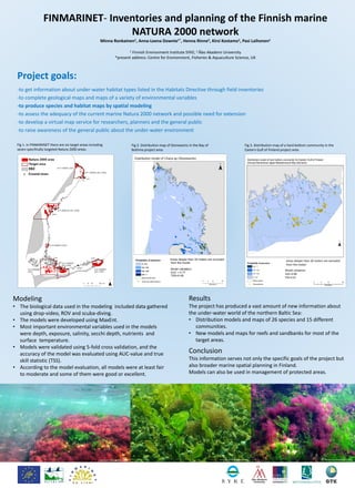
FINMARINET- Inventories and Planning of the Finnish Marine Natura 2000 Network
1. FINMARINET- Inventories and planning of the Finnish marine
NATURA 2000 network
Minna Ronkainen1, Anna-Leena Downie1*, Henna Rinne2, Kirsi Kostamo1, Pasi Laihonen1
1 Finnish Environment Institute SYKE; 2 Åbo Akademi University
*present address: Centre for Environment, Fisheries & Aquaculture Science, UK
Project goals:
-to get information about under-water habitat types listed in the Habitats Directive through field inventories
-to complete geological maps and maps of a variety of environmental variables
-to produce species and habitat maps by spatial modeling
-to assess the adequacy of the current marine Natura 2000 network and possible need for extension
-to develop a virtual map service for researchers, planners and the general public
-to raise awareness of the general public about the under-water environment
Target areas
Results
The project has produced a vast amount of new information about
the under-water world of the northern Baltic Sea:
• Distribution models and maps of 26 species and 15 different
communities.
• New models and maps for reefs and sandbanks for most of the
target areas.
Conclusion
This information serves not only the specific goals of the project but
also broader marine spatial planning in Finland.
Models can also be used in management of protected areas.
Modeling
• The biological data used in the modeling included data gathered
using drop-video, ROV and scuba-diving.
• The models were developed using MaxEnt.
• Most important environmental variables used in the models
were depth, exposure, salinity, secchi depth, nutrients and
surface temperature.
• Models were validated using 5-fold cross validation, and the
accuracy of the model was evaluated using AUC-value and true
skill statistic (TSS).
• According to the model evaluation, all models were at least fair
to moderate and some of them were good or excellent.
H. Arponen Metsähallitus
2008
Areas deeper than 30 meters are excluded
from the model
Model validation
AUC=0.80
TSS=0.41
Fig 1. In FINMARINET there are six target areas including
seven specifically targeted Natura 2000 areas.
M. Westerbom, Metsähallitus 2010J. Nyström, Metsähallitus 2010
Fig 2. Distribution map of Stoneworts in the Bay of
Bothnia project area.
Fig 3. Distribution map of a hard bottom community in the
Eastern Gulf of Finland project area.
H. Arponen, Metsähallitus 2008