SlideShare a Scribd company logo
1 of 53
SURVEYINGKEY POINT
WITH
PAST QUESTIONS & ANSWERS
ISBN: 978-34584-6-6
With
BY:
AMAEFULA IZUCHUKWU .A. N.,
SUR. MADUFOR MICHAEL OZIMS (NAG, ANIS)
With New Academics Syllabus
Published by:
NACCWORLD PRESS 29 CHIKWERE STR. OW. 07038579757
Reverse Standard 3rd Edition
GEOMETRY OF THE CIRCLE
90 B
D
/2=Curve deflectionAngle
90
90
90- /2
EC (End of Curve)
Sub tangent (T)
= Deflection Angle
External (E)
Length of Curve (LC)
Long Chord (LC)
Forward Tangent (FT)
Radius (R)
Beginning of Curve BC
Back Tangent BT
PI V
O=Center of Curve
0+00
Mid-ordinate
Point of Tangent
T1
90- /2
NEWSURVEYINGKEYPOINTWITHPASTQUESTIONS&ANSWERSBY:AMAEFULAIZUCHUKWU.AWITHNEWACADEMICESSYLLABUS(3rdEdition)
i ii
Preface
This book Surveying Key point presents a classical
approach in the field of surveying by providing a vivid
insight into the theory and practical of surveying and its
application through solving various problems in the field
of surveying. Its depth and breadth also makes it ideal
for self-study. It aims at helping students understand
surveying more comprehensively through solving field
related problems useful not only to Land Surveyors but
also to all environmental and civil profession.
A number of past questions and answers which are
nowadays commonly used in many competitive
examinations such as SURCON, COREN and
NIQS/TPPC have been included on each topic to help
the readers to get better score in such examinations. In
keeping with the goal of providing an up-to-date
presentation of surveying equipment and procedures,
Total Stations are stressed as the instruments for
making angular and distance observations. GPS is
commonly used to establish controls, create maps, and
lay out plans. EDM is used for making distance
measurements only. Digital Levelling is used to
determine the difference in height of points on the earth
surface. The practicing Engineers and Surveyors will
also find this book very useful in their career while
preparing designs
and layouts of various application-oriented projects.
-Anih Francisca K (Surv)
First Published 2012
Second Published 2013
Third Published 2015
Reversed Third Published 2017
Copyright © Amaefule Izuchukwu Alauku
+2347064649087
+2348163991115
All right reserved. No part of this book may be
reproduced by any means electronic or mechanical,
including photocopying, recording taping or other
information storage and retrieval system without the
written permission ofAuthor and the Publisher.
Printed by: Naccworld Printing Press @ 29 Chikwere
Street Owerri, Imo State. 07038579757, 07038655576
Distributors are wanted Nation Wide.
Contact the author @ Heroizu Technology Services
Ltd
Head Office
HeroizuTech Complex, Off Nekede Poly Road,
By 3Nity Junc., Nekede, Owerri, Imo State.
Website:www.heroizutech.com.ng
Blog Site: www.heroizutechng.blogspot.com.ng
https://mypedagogue.blogspot.com.ng
Phone: +2347064649087,
+2348181554446,
+2348163991115
Surveying Key Point With Past Question & Answers Surveying Key Point With Past Question & Answers
DEDICATION
This piece of inspired book is divinely
dedicatedto
GodTheFather,
The Son,
&TheHolySpirit.
Also to my beloved parents Mr. & Mrs. King
Josiah Alauku .A. U. and to my beloved
brothers, King Ezieke, Ambassador Chidi,
G o v e r n o r U c h e s o n , L i v i n g s t o n e
Nwachukwu, Prince Kenneth and to my
belovedsisterPrincessBlessing.
iii iv
FORWARDED
Almost all surveying requires some calculations to
reduce measurements into a more useful form for
determiningdistance,earthworkvolumes,landareas,
etc.
At a glance, the book SURVEYING KEY POINT, is
of theoretical and field importance having covered
series of modern topics as taught with school
academics syllabus in Monotechnics, Polytechnics
and Universities offering surveying and
geoinformaticsandaffiliates.
The book provide answers to questions concerning
surveying field problem from various angle with in-
depth knowledge from his research work and field
practices.
Contains the basic information which surveyors need
inachievingtheirdailytaskinthefieldofpractices.
With the aforementioned, I recommend this Hand
Book for students, lecturers, field practices surveyors
and those writing their professional exams because of
itssimplicityandcoverage.
SURV. CHUKWU FEDELIS
HOD, SURVEYING & GEOINFORMATICS
FEDERALPOLYTECHNIC, NEKEDE
OWERRI, IMO STATE, NIGERIA.
Surveying Key Point With Past Question & Answers Surveying Key Point With Past Question & Answers
ACKNOWLEDGMENT
My first thanks goes to theAlmighty God who
in spite of my nothingness and ingratitude
initiated me to write this book. I will like to
appreciate the effort of my friends, Surv.
Olusegun Ayodapo .F, Miss Anih Fransica .K.
(Surv.), Akpan Frank (Surv.), Maduabuchi
anyanwu (Surv.), and Also to say thanks to all
surveyors nationwide.
Acknowledgement also goes to Surv. Obi
(Okopoly), Surv. Ibedu Geo (HOD
Unwanapoly), Surv. C. Fedelis (HOD Nekede
Poly), Surv. R. O Asonibare (HOD Kwara
Poly), Surv. R. U Odidika (MLH & UP, Imo
State), to all YSN, NIS and SURCON
Members and to all my lecturers within and
outside the country who have made me what I
am today. I am not forgetting the presence of
the Redeemed Christian Church of God
members, NIFES member, CASOR
members and other fellowships for their help
andsupport.MayGod blessyouallAmen.
CHAPTER ONE
INTRODUCTION…………………………....…….....…….1
HISTORICAL BACKGROUND OF SURVEY AND GEO-
INFORMATICS…………………………...…..……....……1
W H Y T H E S T U D Y O F S U RV E Y I N G & G E O -
INFORMATICS………................……………………...…..1
JOBS/CAREERS IN SURVEYING AND GEO-
INFORMATICS ............................................................2
CHAPTER TWO
What is
SURVEYING………………………………...........…3
T Y P E S O F S U R V E Y I N G A N D I T ' S
OBJECTIVES….............3
P U R P O S E A N D U S E S O F S U R V E Y I N G
……….......……….4
CHAPTER THREE
BASIC PRINCIPLES OF SURVEYING QUESTIONS &
ANSWERS
……………………………...…………............…9
CHAPTER FOUR
FIELD ASTRONOMY PASTS QUESTIONS AND
ANSWERS………………..……………………...………….5
8
CHAPTER FIVE
CONTROL SURVEYING PASTS QUESTIONS AND
ANSWERS……………............……………………………..
CHAPTER SIX
ENGINEERING SURVEY PASTS QUESTIONS AND
A N S W E R S
……………………………..….......................…63
E L E M E N T S O F S I M P L E
v vi
Surveying Key Point With Past Question & Answers Surveying Key Point With Past Question & Answers
CHAPTER ONE
INTRODUCTION
HISTORICAL BACKGROUND OF SURVEY AND GEO-
INFORMATICS
Surveying has been an essential element in the
development of the human environment since the beginning of
recorded history (ca. 5000years ago) and it is a requirement in the
planning and execution of nearly every form of construction.
Surveying as a foundation discipline in Engineering,
Environmental Sciences and Planning, provides training in the
spatial location of the earth's features, providing in the process of
the environmental information necessary for designing of
engineering works, spatial planning, and land administration etc.
The surveyor is not only a professional and academic Geoscientist
but also must have a good knowledge of physics, mathematics and
able to work in a multi-disciplinary team comprising the
environmentalanalystsandplannersetc.
W H Y T H E S T U D Y O F S U RV E Y I N G & G E O-
INFORMATICS
As the name implies, the Programme provides the
theoretical knowledge and practical skills to create geographic
information systems and to develop a scientific approach to the
fundamental issues in respect of development and use of these
systems. It is often used to establish land maps and boundaries for
ownershiporgovernmentalpurpose.
Since the problems a surveyor attempts to solve are of
diverse nature, his education must be oriented accordingly.
Therefore, surveying students must be well trained in the
following areas: - Remote sensing, Geodesy, Hydrographic
surveying, Photogrammetry and land surveying which includes
Cadastral, Topographic surveying and engineering surveying. In
the area of Geo-informatics, it helps in analytical, data collection
andmanagementinourglobaldevelopmentsystem(Earth).
JOBS/CAREERS IN SURVEYING AND GEO-
INFORMATICS
It has become a question to many parents who find their children
studying this course, and also some of the student who find
themselvesinthiscourseduetoadmissionfrustration.
Because of this, these student are found not doing well in
their exams and in their results, while some lack the basic fact
(The practical aspect) that build up the course survey at the end
oftheiryearofstudy.Theyarefoundnotbeensuccessfulinlife.
As a survey student, you have to know that there are many
job opportunities for you. When you become a graduate in this
field. When you become a graduate and now pass through the
SURCON/NIS exam, you will definitely become a registered
surveyor nationwide. As a surveyor, you can carry out any
survey contract anywhere within and outside the country and
evenacross internationalboundaries.
Some of the opportunities for you as a surveyor are
numerous and you are required for employment in the following
sectors:- Oil and Gas, Mining Industries, Construction
Companies, Navigation Services, Private Practice, Academic
Sectors as Lecturers, Staff etc, Civil engineering consulting
Officersandmanyothers.
Now you have known some of the places you can find
yourself as a surveying and geo-informatics student, all you have
to do now is to involve yourself in every practical and
assignment given to you. This will help you to understand the
course and at the end of every exam, you will come out with a
goodresultbothinpracticalaspectandintheories.
THE QUALIFICATION OFASURVEYING STUDENT
Surveying is a professional course leading to the
Bachelor of Science (Bsc) orTechnology orientation through the
polytechnic leading to Higher National Diploma (HND). It is
obtained on 5years standard schedule or a maximum of in for
four(4)yearsthroughdirectentryintotheuniversity.
Page 1 Page 2
Surveying Key Point With Past Question & Answers Surveying Key Point With Past Question & Answers
CHAPTER TWO
SURVEYING
what is Surveying
Surveying is the art, science and technology of obtaining
angular and linear measurement, using them direct and indirectly
to calculate the data which are then plotted to show the size,
position and slope of a portion. Also, Surveying is the art and
science of measuring distances, direction and elevation to
determine the relative positions of features on the earth's surface
andtheirrepresentationintheformofmaps,plansandcharts.
TYPES OFSURVEYINGAND IT'S OBJECTIVES
Therearetwomaintypesofsurvey.
1. Geodetic Surveys: Are precise and over large areas
requiring the curvature of earth to be considered. Distances
andanglemeasurementsmustbeveryaccurate.While
2. Plane Surveys: It is the survey which considers the surface
of the earth to be a plane. Curvature is ignored and
calculations are performed using the formulas of plane
trigonometry and the properties of plane geometry. These
maybeconsideredaccurateforlimitedareas.
Branchesof Surveying
1. Engineering Surveys: It is a survey which involves the
collection of data that is needed to plan and design
engineering projects. The information ensures the
necessary position and dimension control on the site so that
thestructureisbuiltintheproperplaceandas designed.
2. Route Survey: They are necessary for the design and
construction of various engineering projects such as roads,
railways,pipelines,powerlinesandcanals.
3. Topographic Surveys: Survey that are performed to
gather data that are necessary to prepare topographic
maps. These are multi-colour contour maps portraying
the terrain, and rivers, highways, bridges and other man-
madefeatures.
4. Mine Survey: It is a survey that determine the position of
underground works such as tunnels and shafts, the
positionofsurfacestructuresandthesurfaceboundaries.
5. Industrial surveys, or Optical Metrology: Are survey
used in the aircraft and other industries where very
accuratedimensionallayoutsarerequired.
6. Hydrographic Surveys: It is a survey that is used to map
the shorelines of bodies of water; chart the bottom of
streams, lakes, harbour and coastal water, measure the
flow of rivers; and assess other factors affecting
navigation and water resources. The sounding of depths
byradarisinvolvedinthistypeofsurvey.
PURPOSEAND USES OFSURVEYING
The main purpose of surveying is to produce a surveying plan,
chartormap.
Uses ofSurveyingplanare:
1. For theregistrationoftitle
2. For obtaining the certificate of occupancy (C of O) of a
parcelofland.
3. For landtransactions
4. For planningofvariousdevelopmentsonland
5. For settlinglanddisputecasesincourts.
Theprocesses ofexecutingasurveyplan
Survey traverse work involves several basic steps to plan and
execute.
i. researchingexistingcontrolintheprojectarea
ii. designsurveytomeetspecifications
iii. determinetypesofmeasurements
Page 3 Page 4
Surveying Key Point With Past Question & Answers Surveying Key Point With Past Question & Answers
iv. determinetypesofinstruments
v. determinefieldprocedures
vi. sitereconnaissanceandapproximatesurveys
vii.installmonumentsandtraversestations
viii. datacollection
ix. datareduction
x. dataadjustment
xi. preparesurveyreport
xii.Submissionofthefieldwork
WHAT IS TRAVERSING
TraverseSurvey
This is a method of surveying in which a frame work of traverse is
establishedinthefieldtobesurveyed.
Types ofTraversing
1. Chain Traversing: It may be accomplished with chain as
theprincipalmeasuringdevice.
2. Compass Traversing: It may be accomplished with
compassastheprincipalmeasuringdevice.
3. Plane tabling Traversing: It may be accomplished by
plotting the traverse in accordance with the procedure for
planetablesurvey.
4. Theodolite Traversing: Theodolite is employed by taking
observationsforplottingthetraverse.
5. Tachometric Traversing: Here the traverse is plotted with
thehelpoftachometricobservations.
To accomplish traversing, both the linear and angular
measurements are necessary. On like chain survey that is based on
triangulation i.e. can be accomplished with linear measurements
only.
Importanceoftraversingincludes:
1. Todeterminethepositionsofexistingboundarymarks.
2. Toestablishthepositionsofboundarylines.
3. To establish control for locating rail roads, high ways and
otherconstructionwork.
4. To establish ground control for photogram metric
mapping.
5. To determine the positions of arbitrary points from which
data may be obtained for preparing various type of maps,
i.e.toestablishcontrolformapping.
6. To determine the area encompassed within the confines
ofaboundary.
Reconnaissance
It is the first step to be carried out when surveying or setting
outanewsite.Itinvolvesthefollowing:-
1. To determine suitable field processes and to select
equipmentandmaterials.
2. To locate existing survey control point to connect plan
andlevel.
3. Toplantcontrolstationpositions.
4. Toplanthecorrelationbetweencontrolanddetailwork.
5. Toassess potentialproblemse.g.obstacles.
6. Toinvestigatelandownershipandaccess.
7. To ascertain the importance of man-made features such as
roads,structuresandservices.
BasicPrinciplesofSurveying
These are rules and regulation guiding the practice of
Surveying in order for our results/readings to be accurate and
precise.
1. TheprincipleofcontrolorWhole-To-Part.
Here the surveyor is expected to establish the location,
area,boundariesetc.beforehiswork willbeaccepted.
Page 5 Page 6
Surveying Key Point With Past Question & Answers Surveying Key Point With Past Question & Answers
 Control point: This is the starting point or reference point
to which a survey is connected to. Co-ordinate of points
tellsyouhow farthepointisfromtheoriginalpoint.
 Whole-To-Part: “Whole” is the perimeter of the survey
plan or the enclosure that define the whole area while “To
part” means fixing in the features (details) within the parcel
oflandonehassurveyed/measured.
2. EconomyofAccuracy:
This means that you should be very careful when surveying
i.e. following this rules and regulation of survey. This can
save time, material, money etc. In other words it means
using sophisticated material when the need arise and
instrumentofloweraccuracywhentheneedalsoarise.
3. WorkingConditions
 When the sunshine is to intense close/end your work
because reflection of light can deviate you from the main
point.
 Whenitisrainingstopyourwork.
 Whenyouaretired.
 Disturbanceofmosquitoes.
4. Independent Check:
Thisreferstomeasuringalengthbothfromthefrontand
backwardandcheckifthetworesults/readingsarethe
same.Sometimesformula(Zn+4)rightangle(For
externalAngle)or(zn-4)rightanglefor(Internalangle).
Insummary,independentcheckinvolvescheckingof
calculations/computationmanytimestoavoiderror.
5. Consistency: Here the equipment or instrument you are
using should not be too sophisticated or too low for the
precise value of yours measurement i.e. the degree of
carefulnessshouldmatchtheaccuracyofthejob.
6. Safe guarding: This means keeping records that are
durable or marks that will last to safeguard pillars or land
beacon made by a surveyor for future references. Also
using inks/pen that will not wipe away easily to write our
computations.
7. Revision: This means to re-survey a particular prepared
survey to remove features that are no longer in existence
andaddthosenewfeaturesonthenewsurveyplan.
PROCEDURE FOR RUNNING A TRAVERSE
To begin any traverse, a known point must be occupied. (To
occupy a point means to set up and level the transit or
theodolite, directly over a monument on the ground
representing that point.) Next, a direction must be established.
This can be done by sighting with the instrument a second
known point, or any definite object, which is in a known
direction from the occupied point. The object that the
instrument is pointed to in order to establish a direction is
known as a backsight. Possible examples would be another
monument on the ground, a radio tower or water tank on a
distant hill, or anything with a known direction from the
occupied point. A celestial body such as Polaris or the sun
could also be used to establish an initial direction. Once the
instrument is occupying a known point, for example point
number 2, and the telescope has been pointed toward the
backsight, perhaps toward point number 1, then an angle and
a distance is measured to the first unknown point. An unknown
point being measured to is called a foresight. With this data,
the position of this point (let's call it point number 100) can be
determined. The next step is to move the instrument ahead to
the former foresight and duplicate the entire process.
Page 7 Page 8
Surveying Key Point With Past Question & Answers Surveying Key Point With Past Question & Answers
ProcedureforReducing and Computation ofFieldData
nd st
1. 2 leftminus(-) 1 left= HorizontalRight.
st nd
2. 1 rightminus(-)2 right= HorizontalRight.
nd st 0
3. If2 leftis less than1 left,add360 ….
st nd 0
4. If1 rightisless than2 right,add360
Togetforwardbearing,addassumemeantotheangle
0
and subtract360 .
0
For backward bearing, add 360 to the FB. When given assume
mean,(FB)add180to FB togetthe BB ofdassumemean.
st
1 Stn= BB ofAm+Angle–360= FB, FB +180= BB.
nd st
2 Stn= BB of1 Stn+Angle–360= FB, FB +180= BB
Methods ofMeasuringHorizontalDistances
1. Placing: - This is an approximate method of measuring
distances.
2. Odometer: - An odometer converts the number of
revolution of a wheel of a known circumference to a
distance.
3. Tachometry: - Here, distance is not measured directly but
indirectly with the help of an optional instrument called
tachometer.
4. Electronicdistancemeasurement(EDM)
5. Chains: - are used to measure distances when very great
precisionsarenotrequired.
6. Tape.
 There are fourmain methods used in fixing the position of
apointonthehorizontalplane.
1. By triangulation from two points whose positions are
already fixed and known.
2. By bearing and distance from a single fixed point.
3. By offset from a chain line.
4.Byresection.
Traverse Computation
The various steps in traverse computation will now be
carried out, with reference to the traverse field procedure.
The observed horizontal angles and distances are explained
below.
A common practice is to assume coordinate values for a
point in the traverse, usually the first station, and allocate an
arbitrary bearing for the first line from that point. For
instance, point A has been allocated coordinates of E
1000.00, N 2000.00, and line AB a bearing of 0◦ 00’ 00’’. If
values of E 0.00, N 0.00 had been chosen there would have
been negative values for the coordinates of some of the
stations. Negative coordinates can be confusing. This has the
effect of establishing a plane rectangular grid and orientating
the traverse on it. As shown, AB becomes the direction of
the N-axis, with the E-axis at 90◦ and passing through the
grid origin at A.
The computational steps, in the order in which they are
carried out, are:
(1) Obtain the angular misclosure W, by comparing the sum
of the observed angles (α) with the sum of error-free angles in
a geometrically correct figure.
(2) Assess the acceptability or otherwise of W.
(3) If W is acceptable, distribute it throughout the traverse in
equal amounts to each angle.
(4) From the corrected angles compute the whole circle
bearing of the traverse lines relative to AB.
(5) Compute the coordinates (ɵE, ɵN) of each traverse line.
(6) Assess the coordinate misclosure (ɵE, ɵN).
(7) Balance the traverse by distributing the coordinate
misclosure throughout the traverse lines.
(8) Compute the final coordinates (E, N) of each point in the
traverse relative to A, using the balanced values of ɵE, ɵN per
line.
Page 9 Page 10
Surveying Key Point With Past Question & Answers Surveying Key Point With Past Question & Answers
Page 11 Page 12
The above steps will now be dealt with in detail.
(1) Distribution of angular error:
The majority of the systematic errors associated with horizontal
angles in a traverse are eliminated by repeated double-face
observation. The remaining random errors are distributed
equally around the network as follows.
In a polygon the sum of the internal angles should equal
(2n−4)90◦, the sum of the external angles should equal (2n +
4)90◦.
n
∴ Angular misclosure = W =Σ ai − (2n ± 4)90◦ = −50"1 =1
Where α = observed angle
n = number of angles in the traverse.
The angular misclosure W is now distributed by equal amounts
on each angle, thus:
Correction per angle = W/n = +10"
However, before the angles are corrected, the angular misclosure
W must be considered to be acceptable.
If W was too great, and therefore indicative of poor observations,
the whole traverse may need to be re-measured.
Example 6.3 The coordinates of A, B and C (Figure 6.27) are:
EA 1234.96m NA 17 594.48m
EB 7994.42m NB 24 343.45m
EC 17 913.83m NC 21 364.73m
Observed angles are:
APB = α = 61◦ 4’ 46.6"
BPC = β = 74◦ 14’ 58.1"
Find the coordinates of P.
(1) From the coordinates of A and B:
ɵEAB = 6759.46, ɵNAB = 6748.97
∴ Horizontal distance AB = √(ɵE2 + ɵN2) = 9551.91m
Bearing AB = tan−1 (ɵE/ɵN) = 45◦ 02’ 40.2"
(or use the R→P keys on pocket calculator)
(2) Similarly from the coordinates of B and C:
ɵEBC = 9919.41 m, ɵNBC = −2978.72 m
∴ Horizontal distance BC = 10 357.00 m
Bearing BC = 106◦ 42’ 52.6"
From the bearings of AB and BC:
C ˆBA = φ = 180◦ 19’ 47.6"
Surveying Key Point With Past Question & Answers Surveying Key Point With Past Question & Answers
CHAPTER THREE
SURVEYING QUESTIONS & ANSWERS
1. Qs. list and explain the three reference axes of a total
station?
Ans. 1. Theaxisofsightorlineofsight
2. Thehorizontalaxisand
3. Theverticalaxis.
2. Qs.Whenwillyouapplyparallaxintotalstation?
Ans. Parallax method is applied when the focusing of the two
lensesis notcoincident.
3. Qs.Explainwhatisparallaxcorrectionintotalstation?
Ans. Parallax is the apparent motion of an object caused by a
movementinthepositionoftheobserver's eye.
4 Qs. Enumerate at least, six functions of contour lines
embeddedinatopographicplan?
Ans. NOTE: A contour is a line connecting points of equal
elevation.They are lines drawn on a plan; it is also, a line on
amapjoiningpointsofsimilarelevation
THE FUNCTIONS OFCONTOUR LINES
1. Surveyors and engineers most often use contours to depict
relief.
2. On maps, contours represent the planimetric locations of
thetracesoflevelsurfacesfordifferentelevation.
3. The distance between contours indicates the steepness of
slope. While separation denotes gentle slopes; close
spacing.
4. Irregular contours signify rough, rugged country. Smooth
linesimplymoreuniformlyrollingterrain.
5. Concentric closed contours that increase in elevation
representhills.
6. Contours are perpendicular to the direction of maximum
slope.
5. Qs.DifferentiatebetweenTachometerandTachometry?
Ans. Tachometer: it is a vernier theodolite fitted with stadia
diaphragm. It has three horizontal hairs, one central and
othertwoequidistantfromcentralhair.While.
Tachometry: is a rapid and economical surveying method by
which the horizontal distances and the differences in elevation
are determined to scale using angels observed with a transit or
thetheodolite.
6. Qs. Distinguish between planimetric and topographic
maps?
Ans. Planimetric maps: they are scaled maps showing the
scaled horizontal locations of both natural and cultural
features.Itis alsocalled“Ortho-photomaps”
WhileTopographicmap:isthemapshowing spotelevations
andcontours.
7. Qs. features represented in topographic maps are either
naturalorartificial.Nameanythreeofeachcase
Ans. Natural features includes: stream banks, rock, trees,
rivers, etc. while Artificial features includes: buildings,
railwaytracks,bridgesandpipelines.
8. Qs.Listfivecharacteristicsofcontours?
Ans.1.Closelyspacedcontoursindicatesteepslopes
2. Widelyspacedcontoursindicatemoderateslopes
3. Contoursmustbelabeledtogivetheelevationvalue.
Page 13 Page 14
Surveying Key Point With Past Question & Answers Surveying Key Point With Past Question & Answers
4. Contoursarenotshown goingthroughbuilding.
5. Contourlinescannotbeginorendontheplan.
6. Theycannotcross eachother.
9.Qs.Whatis mapscale?
Ans. Map scale is the ratio of the length of an object or feature
onamaptothelengthoftheobjectorfeature.
10.Qs. Give three ways which scales can be represented with
examples
Ans. MapScalecanberepresentedby
1. Byratioorrepresentativefractionsuchas1:2000or1/2000.
2. Byanequivalence,forexample,1in=200ft.
3. By graphically using either a bar scale or labeled grid lines
spacedthroughoutthemapatuniformdistancesapart.
*And also, map scales may be classified as large, medium, and
small.Therespectivescalerangesareasfollows.
1. Largescale,1in.=200ft(1/2400)orlarge
2. Medium scale, 1in. = 200ft to 1in. = 1000ft (1:2400 to
1:12,000)
3. Smallscale,1in.=1000ft(1:12,000)orsmall.
*AreasofApplication.
1. Large scale are applied where relatively high accuracy is
needed over limited areas; for example, in subdivision
design and the design of engineering projects like roads,
dams,airportsetc.
2. Medium scale are often used for applications such as
general preliminary planning where larger areas are
covered, but only moderate accuracy is needed. E.g.
mapping the general layout of potential construction sites;
proposedtransportationsystems.
3. Small scale maps are commonly used for mapping large
areas where a lower order of accuracy will suffice. They
aresuitableforgeneraltopographiccoverage.
Page 15 Page 16
BASIC PRINCIPLES IN SURVEYING
11. Qs. Explain what is meant by the term “Working from the
WholetoPart”?
Ans. The term “Working from the Whole to Part” is the
principle of laying down overall system of stations whose
positions are fixed to a high degree of accuracy. It is the
principle of working from the area of higher
concentrationtotheareaoflowerconcentration.
12.Qs.Distinguishbetweenplaneandgeodeticsurvey?
Ans. In plane survey, the area of interest is taken to be a
horizontal plane and measurements plotted will represent
the projection on the horizontal plane of the actual field
measurements. While, in geodetic surveying, the
curvature of the earth is taken into consideration and the
knowledgeofsphericalgeometryis needed.
13. Qs. List any three methods of making linear
measurements?
Ans. (1) By using tape (2) By Optical means, and (3) By using
ElectronicsDistanceMeasurement(EDM)
14. Qs.Nameandexplainanyfourbranchesofsurveying?
Ans. (a) Cadastral Surveys: this is carried out in order to define
boundariesofproperties,legislativeareasandcountries.
(b) Geodetic Surveys: this is carried out at the national level
to provide controls to which future surveys can be based.
Here,ahighdegreeofaccuracyisrequired.
(c) Topographic surveys: this involves the measurement of
the physical features of the earth to produce map and plan
showing their relative positions both horizontal or
vertically.
(d) Engineering surveys: this supplies details for particular
engineering works and could include the setting out
Surveying Key Point With Past Question & Answers Surveying Key Point With Past Question & Answers
works onground.
15a.Qs.Belowaremeasurementsmadeoncorners.
(a)Pointsoffivesidedpieceofland
*CalculatetheAreainhectares,usingHero's formula.
Ans. SOLUTIONS
NB:methodsofAreaCalculationsare:
(i) By hero's formula (ii) By double meridian method, and
(iii)ByCross Coordinatemethods
But for irregular figures, the following methods can be
employed: (a) Simpson's rule (b) Prismoidial formula (c) Mid-
ordinateand(e)Average-ordinaterule.
But our emphasis is on the methods for Area of regular figures
whichareusedinthismonograph.
AreabyHero'sformula.
A=√s(s –a)(s –b)(s-c)
Wheres =a+b+c
2
2
For θ ABC
S=40.00+50.000+20.000=110.00/2=55.00
Page 17
50.00
20.00
40.00
C
E20.04
30.00
60.00B
50.00
D
A
b
c
a
50.0020.00
40.00
Surveying Key Point With Past Question & Answers
Page 98
Surveying Key Point With Past Question & Answers
2
A=√55.00(55.00-40.00)(55.00–50)(55.00-20)
=√55.00(15.00)(5.00)(35.00)=√55.00(2625)
A=√144375.00=380.00m²ans.
Forθ ACE
S=50+60+20.004
2
=130.004=65.002; A=√65.002(65.002–50)(65.002–60)
2 (6.002–20.004)
A=√65.002(15.002)(5.002)(44.998)
A=√219489.010
A=468.497m²Ans.
Forθ CDE
S=60+30+50
2
S=140/2=70Ans.
A=√70(70-60)(70-30)(70-50)
A=√70(10)(40)(20)
A=√560000
A=748.331m²Ans.
Totalarea=380.000+468.497+748.331
TotalArea=1596.828m²
InhectaresArea=1596.828m²/10,000=0.160Hectares
Qs. 15b. List any five corrections to be applied to a measured line
PQ tobringittoacorrectedhorizontaldistance.
Ans. Corrections to be applied to a measured line to bring it to a
correctedhorizontaldistanceare:
1) Slope correction 2) Temperature correction 3) Sag correction,
4)Tensioncorrection5)Standardizationcorrection.
16a. Qs. Calculate the corrections to be applied in each of the
following cases to bring the slope distance to horizontal
distances. Hence or otherwise calculate the respective horizontal
distances?
(i) Aslopedistanceof100matanangleofslopeof9˚30'
(ii) A slope distance of 600m where the difference in height
betweenthetwoendsofthestationis20.928m.
SOLUTION
Ans. (i) H = S Cosθ
Where H = horizontal distance
S = Slope distance.
Θ = Angle of slope
H = 100 cos9˚ 30'
H = 98.629m.
From here, correction
C = 100 – 98.629 = 1371m.
This ischeckedthus
C=L(1-cosθ)
=100(1-cos90˚30'=1.371mAns.
(ii) heightdifference=20.928m
Slopedistance =600m
Correctionx=h²/2L
x=20.928² =437.981 =0.365mAns.
2x600 1200
Page 18 Page 19
60.00
50.00
A’ 20.04
E
C
E
C
D
30
50
60
9˚3
100
m
H
Surveying Key Point With Past Question & Answers Surveying Key Point With Past Question & Answers
Therefore;H =600–0.365
H =599.635m.Ans
16b. Qs. After completing a survey, the 100m tape used was
checkedandfoundtobe100.014mlong.
(i) Calculate the correct length of a line measured as 450.00m
withtheincorrecttape.
(ii) If the area of land surveyed with the incorrect tape is 7.182
hectares,calculatethecorrectareaoflandsurveyed.
SOLUTION
Norminallengthoftape=100m
Reallengthoftape=100.014m
Measuredlength =450.00m
Norminalarea=7.182hectares
(i) Norminallengthoftape =measuredlength
Reallengthoftape reallength
 100 = 450
100.14P
100P=45000.3
P=450.063m.Ans.
(ii) (Norminallengthoftape)²= Norminal
(Reallength)² A
 100² =7.182
100.014² A
=>A=71840.111
10,000
A=7.184HectaresAns.
17. Qs. You are required to carry out a chain survey of a section of
the Polytechnic football field. Give a step by step
description on how you can accomplish the task, indicating
the minimum man-power and equipment required for
executingtheproject.
Ans. Chain survey of a section of the Polytechnic football
field.
Step one: Reconnaissance: Recall that every type of survey
begins with a recce which helps the surveyor to farmilarize
himself with the area of interest. It is after the recce that the
surveyor determines the number of man power and equipment to
useforthesurvey.
Man-power
i. thesurveyor
ii. thechainmanand
iii. 3 other assistance. This is the minimum man-power for
thesurvey.
Equipments
i. chainortape,
ii. Abneylevelformeasuringslopeangle(ifany)
iii. Rangingpolesforranging/settingoutstraightlines
iv. The cross staff & Optical square for right angle setting
out.
Step two. Measurement: Note, chain surveying is carried out by
usinglinearmeasurementonly.
Here, the distances of the section are measured starting from the
longest leg of the section (base line). After completing the
perimeter measurement, the diagonals of the section is also
measuredinaddition.
Step three; Presentation:it is well known that the end-productof
any survey is plan/map. Here, the plotting is done using the base
line and the diagonals as a guide. This is done on a cartridge
paperbasetoshow theareaundersurvey.
Page 20 Page 21
Surveying Key Point With Past Question & Answers Surveying Key Point With Past Question & Answers
SUG/102
18. Qs. In order to determine the depth at various points in a lake, a
surveyorobtainedthefollowinglevelingdata,from b e n c h
mark BM1to BM2.
If the reduced level of change CH0 + 000 is 100.000m above
MSL. Compute the leveling data of other points using any
method.Applyallnecessarychecksandcorrectionsifpossible.
ANS. SOLUTION
USING HEIGHT OFCOLLIMATION METHOD
1(a)
∑BS-∑FS = 9.904- 9.910 = - 0.006
RLBM2 – RLBM1 = 99.994 – 100.000 = - 0.006
:. Misclosure = - 0.006
Correction = Misclosure x individual distance
Total distance
NB: since the Misclosure is negative, correction will be
positive.st
For 1 change: c = 0.006 x 20 = 0.0008
= +0.001
B.S I.S F.S REMARK
1.510 - BM1 (CH0+000)
1.520 1.425 C.P1(CHO+020)
1.541 PointA
1.540 1.528 C.P2 [CH0+040]
1.335 Point B
1.325 1.520 C.P3 [CH0+060]
1.498 Point C
1.305 1.349 C.P4 [CH0+080]
1.473 Point D
1.335 1.250 C.P5 [CH0+100]
1.280 Point E
1.369 1.429 C.P6 [CH0+120]
1.409 BM [CH0+140] [TOP OF
BM2]
BS IS FS HI UNCORRE
CTED RL
(m)
CORR
N
CONFIDEN
TIAL RL(m)
REMARK
1.510 - - 101.5
10
100.000 _ 100.000 BM1(CH0+000)
1.520 - 1.425 101.6
05
100.085 +0.001 100.035 CP1(CH0+020)
1.541 - 100.064 +0.001 100.065 PtA
1.540 - 1.528 101.6
17
100.077 +0.002 100.079 CP2(CH0+040)
1.335 100.282 +0.002 100.284 PtB
1.325 - 1.520 101.4
22
100.097 +0.003 100.100 Cp3 (CH+060)
1.498 99.924 +0.003 99.927 ptC
1.305 - 1.349 101.3
78
100.073 +0.003 100.076 CP4(CH0+086)
1.473 99.905 +0.003 99.908 ptD
1.335 - 1.250 101.4
63
100.128 +0.004 100.132 CP5(CH0+100)
1.280 100.183 +0.004 100.187 P7E
1.369 1.429 101.4
03
100.034 +0.005 100.039 CP6(CH0+120)
1.409 99.994 +0.006 100.000 BM2(CH0+140)
∑=9.90 ∑
9.9104
Page 22 Page 23
Surveying Key Point With Past Question & Answers Surveying Key Point With Past Question & Answers
CHECKS
RL+ BS = HI
HI – FS = RL
HI - IS = RL
∑BS -∑FS = RLBM2– RLBM1Ans.
USING RISEAND FALLMETHOD
CHECKS
∑BS =∑FS =-0.006
∑Rise- ∑fall=0.730 –0.736=-0.006
RL – RL =-0.006Ans.BM2 BM1
19a(ii) Sketchthesection
Ans.
100
DATUM
20 40 60 80 100 120 140
0.000
NOTE:Thesketchis nottoscale.
(b) Qs. State the precautions which should be carried out on the
fields during a leveling exercise in order to eliminate or
minimizeerrors.
Ans.
Precautions on leveling: In order to eliminate or minimize errors in
leveling,thefollowingprecautionsmustbecarriedout.
(i) Ensuretheverticalityof thestuff
(ii) Instrumentshould notbeseton avibratingground
(iii) Ensure that the instrument is leveled before talking any
reading.
(iv) Leveling should not be done under a hot sun to avoid
refraction.
(v) Levelingshould notbecarriedoutunderrain
(vi) The tripod which the instrument is mounted must not be
touched after the instrument has been leveled to avoid
dislevelment.
(vii) At every change point, the staff man must not move the
staff from the base but only turn the face of the staff to face
theinstrument.
BS IS FS RISE
+ve
FALL
-ve
Uncor.
RL
Cor. Final RL Remark
1.510 - - 100.000 - 100.000 Bm1(CH0+000
1.520 1.425 0.085 100.085 +0.001 100.000
CP1(CH0+020
1.541 0.021 100.064 +0.001 100.065 PtA
1.540 1.528 0.013 100.077 +0.002 100.079 CP2(CH0+040)
1.335 0.205 100.282 +0.002 100.284 PtB
1.325 1.520 0.185 100.097 +0.003 100.100 CP3(CH0+060)
1.498 0.173 99.924 +0.003 99.927 PtC
1.305 1.349 0.149 100.073 +0.003 100.076 CP4(CH0+080)
1.473 0.168 99.905 +0.003 99.908 PtD
1.335 1.250 0.223 100.128 +0.004 100.132 CP5
1.280 0.055 100.183 +0.004 100.187 PtE
1.369 1.429 0.149 100.034 +0.005 100.039 CP6(CH0+120)
1.409 0.04 99.994 +0.006 100.000 BM2(CH0+140)
∑=9.904 ∑=9.9
10
∑=0.7
30
∑=0.7 36
Page 24 Page 25
Surveying Key Point With Past Question & Answers Surveying Key Point With Past Question & Answers
Qs 20a A B
D C
The above figure ABCD is a braced quadrilateral with eight angles
observed in a mirror triangulation scheme. State ALL the angle
conditionstobesatisfiedintheadjustmentofeightangles.
Ans. SOLUTION
2a. BRACE QUADRILATERAL
In the adjustment of the eight angles of the brave quadrilateral above, the
followingconditionsmustbeobserved.
(i) Sumofoppositeanglesareequali.e.
1+2 = 5+6
3+4 = 7+8
0
(ii) 1+2+3+4+5+6+7+8 =360
(iii) Products ofsins of odd angles =1
Products ofsins of evenangles
N/B:Sumoftheinteriorangle=(2n-4) 90.
Qs.( 20b)(i) If the eight angles observed in the triangulation scheme
(Bracedquadrilateral)shown abovearegivenas follows:
1
8
2
3
4
5
7
6
Use the angle conditions stated by you to obtain only the
firstadjustedvaluesoftheangles.
Solution:
b(i)The8anglesofthequadrilateralaregivenasfollows:
360.00 10
-3600000
00 00 10”
=,Misclosure=10”
Correction=10”
0
8 =00 00' 1.25”
ANGLES OBSERVED VALUE
1 52 0
201
44”
2 540
191
46”
3 400
221
55”
4 320
561
41”
5 500
201
40”
6 560
191
56”
7 300
531
29”
8 420
251
59”
ANG
LE
OBSER
VED
VALUES
ADJUSTM
ENT
TO 360
ADJUSTM
ENT
TO
OPPOSITE
<
FRIST
ADJUSTM
ENT
VALUE
1 52 20 44 -1000
00’1.25’ +00 00 1”.5 520
20’ 44.25”
2 54 19 46 -000
00’1.25’ +00 00’ 1.5” 52 20 46.25
3 40 23 55 " -00 0004” 40 22 49”.75
4 32 56 41 " -00 00 04” 32 56 35.75
5 50 20 40 " -00 00 1”.5 50 20 37.25
6 56 19 56 " -00 00 1”.5 56 19 53.25
7 30 53 29 " +00 00 04” 30 53 31.75
8 42 25 59 " +00 00 04” 42 26 1.75
∑ 360 00
10”
Page 26 Page 27
Surveying Key Point With Past Question & Answers Surveying Key Point With Past Question & Answers
SincetheMisclosureis +ve,correctionbecomes–ve.
ThisamountofMisclosureof1.25”isappliedtotheeightangles.
For adjustmenttooppositeangles
1+2=52 20 44
+54 19 46
106 40 30
5+6=50 20 40
+56 19 56
0 0
Misclosure=106 40' 36”–106 4' 30”
0
=00 00' 06”
0 0
Corn=00 00' 06”/4=00 00' 1.5”
Therefore since K1 & 2 is less than 5 & 6, it carried +ve correction
whilethelatercarries–vecorrn
3+4=40 22 55
+32 56 41
73 19 36
7+8=30 53 29
+42 25 59
7319 28
Misclosure=731936–731928
0
=00 00 08”
0
Correction=00 00' 08”
0
4 =00 00' 04”
:.Since7+8isless than3+4,it
Carriesa+vecorrnwhilethelater
Carriesa–vecorrnof4”
Qs 20b(ii) ProvethatProductofsineofoddangles= 1
Productofsineofevenangles.
Toshow that:
(ii) Productsofsins ofodds
Productofsuns ofeven<s =1
sin1xsin3xsin5xsin7 = sin 522044 x sin 402255 x sin
502040xsin305329
sin2xsin4xsin6xsin8 sin541956 x sin325641 x
sin561956xsin422559
=0.20275 = 0.8172 1
0.24809
:.Productsofsins ofodds =1
Productsofsins ofevens
21(a) Below are the coordinates of the corner points of four (4)
sidedpieceof LAND.
ComputetheAREAinhectares
Solution:
Areacal.usingcross coordinates
PILLAR NOS EASTINGS (M) NORTHINGS (M)
SC/IMB 9970 503705.674 163127.593
SC/IMB 9971 503655.762 163162.591
SC/IMB 9972 503664.512 163175.070
SC/IMB 9973 503714.424 163140.071
Pillar Nos Eastings (m) Northings
(m)
A B
SC/IMB9970 503705.674 163127.593 83670.641
SC/IMB9971 503655.762 163162.591 114,736.241 108043.671
SC/IMB9972 503664.512 163175.070 114840.253 125074.210
SC/IMB9973 503714.424 163140.071 93078.860 98844.463
SC/IMB9970 503705.674 163127.593 91,155.501
=
413774.855
= 415632.985
Page 28 Page 29
B–A=415632.985-413774.855=1858.13
2Area=1858.130
Area=1858.130 =929.065sqr meters
2
:.Area=929.065 =0.093 Hectares
10000
Areacalby doublemeridianmethod
Surveying Key Point With Past Question & Answers Surveying Key Point With Past Question & Answers
Doublingthelongitude
-49.912x34.998= -1746.820
x 2
-99.824
+8.750
-82.324
+49.912
-32.412 x-34.999= +1134.388
+49.912
+17.500
- 8.750
8.750x-12.478=-109.183
-8.750
00 2A=-1857.763
Ignoringthenegativesign.
2A=1857.763
2
A=1857.763 =928.882m
2
2
:.Area=928.882m /10,000= 0.093Hectares
(b) 21Qs. Fromtheinformationoncoordinatesshown above.
(i) Calculate the bearing from SC/IMB 9970 to SC/IMB
9971.
(ii) Calculate the bearing from SC/IMB 9971 to SC/IMB
9970
(iii) Calculate the distance from SC/IMB 9970 to SC/IMB
9971
i. Bearingfrom SC/IMB 9970–9971
∆N =34.998
∆E=-49.912
tan =∆E
∆N
-1
=tan ∆E
∆ N
-1
=tan 49.912
34.998
-1
=tan 1.42614
0 1
 =054 57 44”
Referringtosurveychart
E
N
W
∆N+
∆E-
∆E
∆N
∆N+
α=brg
∆E+
∆N+
∆E-
S
th
Sinceitfallsonthe4 quadrant
0 1
brg=3600–54 57 44”
0 1
:.brg=from SC/IMB9970–9971=305 02 16”
0 1 0
(ii) Bankbearing=305 02 16”-180
0 1
=125 02 16”
2 2
(iii) Distance=√∆E +∆N
2 2
=√49.912 +34.998
=√3716.068
=60.960m
Qs. 22(a)
Area cal by double meridian method
E N Easting North Pillar Nos
503705.674 163127.593 SC/IMB9970
-49.912 34.998 503655.762 163162.591 9971
8.750 12.475 503664.512 163175.070 9972
49.912 -34.999 503714.424 163140.071 9973
-8.750 -12.478 503705.674 163127.593 9970
Page 30 Page 31
Surveying Key Point With Past Question & Answers Surveying Key Point With Past Question & Answers
B C
A D
The above figure ABCD is a braced quadrilateral with eight angles
observed in a minor triangulation scheme. State All the angle
conditionstobesatisfiedintheadjustmentoftheeightangles.
Solution:
(a)
(i) For externalangles
=(2n+4)90
Wheren =no of stns
0 1
=(2(4)+4)90=1080 00 00”
1 0
Error=1080 01 40”–1080 0000
0 1
=00 01 40”
1
Correction=0001 40”=25”
4
Thisamountissubtractedfromtheangles
(ii) To checkforallowableMisclosure,30 “√n
=30 “√4
0 1
=30”x 2 =00 01 00”
0 1 0
The error = 00 01 40” but allowable Misclosure for the survey is 00
1
01 00”. Since the error is more than the allowable Misclosure by 40”,
theMisclosureis notallowable.
But if the Misclosure s allowable, it can be corrected as shown in the
tableabove.
22(b) If the eight angles observed in the triangulation scheme
(Bracedquadrilateral)shown abovearegivenas follows:
Using the angle conditions stated by you, obtain only the first
adjustedvaluesoftheangles.
Solution:
STATION OBSERVED
ANGLE
MEASURED
LINE/HORIZONTAL
DISTANCE
A 272
0
521
10” AB = 180.297M
B 2960
431
18” BC = 164.583M
C 2620
131
11” CD = 106.267M
D 2480
131
01” DA = 112.615
STATI
ON
OBSERV
ED
ANGLE
HD CORRECTI
ON
CORRECT
ED
ANGLES
STATI
ON
TO
A 272 23 10 180.2 97 - 25” 272 51 45 B
B 296 43 18 164.5 83 - 25” 296 42 53 C
C 262 13 11 106.2 67 - 25” 262 12 46 D
D 248 13 01 112.6 15 - 25” 248 12 36 A
 = 10800
01’ 40”
Angles Observed value
1 600
28’ 50”
2 420
28’ 23”
3 360
38’ 49”
4 400
23’ 39”
5 450
45’ 41”
6 570
11’ 48”
7 380
15’ 20”
8 380
47’ 00”
Page 32 Page 33
Surveying Key Point With Past Question & Answers Surveying Key Point With Past Question & Answers
To determine the not observed to C, the difference between the
0
faceleftandfacerighttoCshouldbe180
0 0
:.notobserved=293 39' 34”–180=113 39' 34”
23(a) Qs. Below are the coordinates of the corner points of four
(4)sidedpieceofland.
(I)
Computethearea (i)Hectare (ii)Acres
Solution:
23(a)CalAreausingdoublelatitudemethod
Bydoublinglatitude
11.117x-30.007=333.588
x 2
22.234
+25.122
+47.356x11.186=+529.724
+25.122
+72.427
-15.686
56.792x16.820=955.241
-15.686
41.106
-20.553
20.553x2.001=41.127
-20.553
0.000
2A=1192.504
2
A=1192.504=596.25m
2
AreainHectares=0.0596Hectare
AreainAcres=596.252
4000 =0.149Acres.Ans.
23b. Qs. In a substense bar measurement exercise, the theodolite
was set at station A while the substense bar was set at station B
the length of the substense bar is 2m. if the horizontal angle
measured at stationAto the two ends of the bar at station B is 00º
40' 59''. CalculatethehorizontaldistanceAB.
Ans. NB: The substence bar is a tangential system of optical
distance measurement when the measuring base is held
horizontally. The bar length is always 2m and it is always
mounted at the end of the line whose length is required and the
theodolite which measures the parallactic angle is mounted at the
beginningoftheline.
Solutionto5b.
STN
FROM
STN
TO
FACE HCR HA Mean
HA
A
B L 113 49’ 35’’
C L 29 39’ 34’’ 179 49’59’’
C R 113 39’ 34’’
NTObserv
179 50’ 03’’ 359 40’ 02’’
B R 193 49’ 31’’
STATION NORTHINS
(M)
EASTINGS (M)
A 197572.954 520046.062
B 197584.071 520016.055
C 197609.193 520027.241
D 197593.507 520044.061
N E NORTHINGS EASTINGS STN
197572.954 520046.062 A
11.117 -30.007 197584.071 520016.055 B
25.122 11.186 197609.193 520027.241 C
-15.686 16.820 197593.507 520044.061 D
-20.553 2.001 197572.954 520046.062 A
0
0
0
0
0
0 0
0
Page 34 Page 35
Surveying Key Point With Past Question & Answers Surveying Key Point With Past Question & Answers
Lengthof bar=2m
Parallacticangle =00º 40' 59''
Using trigonometryratio
Tan/2=b/2
H
H =b/2 butb =2
tan/2
H = 1/tan /2 =cot /2
H =1/tan(00º 40' 59''/2)
=1/tan00º 20' 29''.5
H =1/0.00596
H =1667.761mAns.
SUG/101/
H
A B
SUG/101/
30mPeg429m
Peg3 Peg5
37m Peg6
22m 32m 30m
30m
26m
Peg7
Peg2 28m
34m
Peg1
24a. Qs. The figure above IS an extract from a chain survey field
book.
Computetheareaofthe LAND ,Using Hero's formulain
i.Hectaresii.Acres
Solution
Computationof areausing hero's formula
A=√s(s-a) (s-b) (s-c)
Wheres =a+b +c
2
For ΔA
S =22 +20 +26
2 =68/2=34
Area=√34(34-22) (34-20) (34-26)
=√34(12) (14) (8)
=√45696 =213.766m²
For ΔB
S = 26+ 30 + 32
2 = 88/2 44
Area = √44(44–26) (44 – 30) (44 –32)
=√44(18) (14) (12)
=√133056 =364.768m²
For ΔC
S =29+30+32
2 =91/2=45.5
Area=√45.5(45,5–29)(45.5–30)(45.5–32)
=√45.5(16.5)(15.5)(13.5)
=√157094.438=396.351m²
Page 36 Page 37
Surveying Key Point With Past Question & Answers Surveying Key Point With Past Question & Answers
For ΔD
S = 37 + 30 + 28
2 = 95/2 = 47.5
Area = √47.5(47.5–37)(47.5–30)(47.5–28)
=√47.5(10.5)(17.5)(19.5)
=√170198.438=412.551m²
For ΔE
S = 28 + 34 + 30
2 = 92/2 = 46
Area = √46(46-28)(46–34)(46–30)
=√46(18)(12)(16)
=√158976 = 398.718m²
TotalArea=A+B+ C+ D +E
= 213.766 + 364.768 + 396.351 + 412.551 +
398.718
THEREFORE:Area=1786.154m²
i. Area=0.179Hectares
ii. Area=0.447Acres Ans.
Qs.24b.Listthesources oferrorsinmeasurement?
Ans. Sources of error in measurement may include the
following
i. Wrongreadingoftape.
ii. Poor ranging
iii. Poor adjustment (iv) Slope (v) Miscounting of tape
length
(vi) Sag (vii) Temperature variation. (viii) Displacement of
stationmark
(ix)Tensionvariation(x)mistakeinbooking.
Qs. 25a. Convert the following Degree Minutes and Seconds to
radians.
1. 64º00' 00”(2)23º01' 01”(3)00º00' 01”
Ans. Whole Circle Bearing (WCB) is always measured
clockwise from North Pole to the lines; its value is
between 0 º to 360 º. This is also called “AZIMUTH”.
While Quadrantal Bearing (QB) is always measured
clockwise or anti-clockwise from North/South Pole
around the four quadrants. It values is between 0 º and 90 º
as NE, SE, SW,& NW.
WCB
WCB
QB
.
25a.convertsthefollowingD. M. S. toradians.
1. 64º00' 00”(2)23º01' 01”(3)00º00' 01”
NB:theconversionfactoris/180inradians
Solution: (i) 64º 00' 00” x /180 = 64 x 3.142/180 = 1.1170
rad.
(i) 23º01' 01”x3.142/180=0.4018rad.
(ii) 00º00' 01”x3.142/180=4.849x10^-6
25a(ii)converttheradianstodegree,minutesandseconds.
Whole Circle Bearing (WCB) is always measured clockwise
0 0
fromNorthpoletothelines,itsvalueisbetween0 to360 .
This is also called “AZIMUTH”. While Quadrantal
Bearing (QB) is always measured clockwise or anticlockwise
from North/South pole around the four quadrants. It values is
between00and900as NE, SE, SW& NW.
Page 38 Page 39
Surveying Key Point With Past Question & Answers Surveying Key Point With Past Question & Answers
(25a)
(i)ConvertthefollowingD mstoradians
0 1
(i) 64 00 00”
0 1
(ii) 23 01 01”
0 1
(iii) 00 00 01”
П
NB,theconversionfactorsis / inradians180
Solution:
0 1 П
(i) 64 00 00”x / =64x3.142=1.1170rad.180
180
(ii) 23 01 01x3.142= 0.4018rad
180
0 1 -6
(iii) 00 00 01”x1.342=4.849x10 rad.
180
(ii)Convertthefollowingradiansto DMS
(i) 1.12067
(ii) 1.42055
(iii) 1.86344
Here,theconvertingfactoris 180/Пinpeg.
S o l u t i o n :
180 0 1
(i) 1.12067x / = 64 12 35”П
180 0 1
(ii) 1.42055x / =81 22 52”П
180 0 1
(iii) 1.86444x / = 106 46 02”П
25b (i)
Theprocessesinsurveyingare:
(1) Reconnaissance
(2) Measurement
(3) Officecomputation
(4) FinalPresentation
RECONNAISSANCE (Recce): This is the first step carried out
in any survey work. It involves going round the area to be
surveyed for familiarization. It is during this process that surveyor
chose his station points and from this process, the surveyor
decides on the type of instruments, man power, the cost and the
method of survey to be employed. During this process, the
survey live is cleared between 2 – 2.5m wide for visibility and
thereccediagramoftheareais drawn.
MEASUREMENTS: This is done after recce depending on
the statement of survey, purpose and the accuracy required, the
necessary measurements is carried out in the field with their
appropriate instrument to determine the size, shape and relative
position of features. The necessary parameters measured in the
field include, distances, angles and difference in heights
between points. Such measurements are systematically booked
inafieldbookforsubsequentuseincomputation.
OFFICE COMPUTATION: Here, the observed data in the
fieldarecomputedandadjustedforuseinthefinalproduction.
FINAL PRESENTATION: In any survey, the collected data
must be presented in a way that must be clearly interpreted and
understood by others. After the office computation &
adjustment, the plan or map is then produced with a suitable
scalethedepictthenatureofthearea.
25b (ii)
NB: Plane table surveying is a survey method whereby field
measurements and plotting are carried out simultaneously in the
field.
USES
(1) Is used in supplying topographic details for air
survey.
(2) Used inmaprevision
(3) Used in carrying out reconnaissance for triangulation
scheme.
(4) Used in the survey of small site where graphic
Page 40 Page 41
Surveying Key Point With Past Question & Answers Surveying Key Point With Past Question & Answers
accuracyis required.
(5) It illustrates to the students, the principles of surveying
like;resection,triangulationandtraversing.
Qs. 26(a) prove that the slope correction to a measured line PQ,
wheretheheightdifferencebetweenPandQ is givenasx=h²/2L
NB:Approachtoslopecorrectioncanbein2ways
(i) Bymeasuringtheslopeangle
(ii) By measuring the height difference between the end
points.
Measurementofheightdifferencebetweentheendpoints.
By Pythagoras theorem. P R x
Consider PRQ
L
2
= H
2
+ h
2
But H = L – x L h
L2
= (L-x)2
+ h2
L2
= L2
= L2
– Lx – Lx + x2
+ h2
L2
= L2
– 2Lx + x2
+ h2
2Lx = x2
+h2 Q
x=x2
+h2
2L
x = x2
+ h2
H
2L 2L
2
Butx canbeneglectedbecauseitis so smallandthus
2L
2
x=h
2L.
NB: Slope correction is always negative because slope distance
arealwayslongerthanHorizontaldistance.
26(b) After completing a survey, the 50m tape used was checked
and found to be 50.014m long. i. Calculate the correct length of a
line measured as 150.000m with the incorrect tape. ii If the area of
the land surveyed with incorrect tape is 450.000m². calculate the
correctareaofthelandsurveyed.
Ans.
(i) Norminallengthoftape=50m
Actuallengthoftape=50.014m
Measureddistance=150.000m
LetPbecorrectlengthoftape
Normallength = Measureddistance
Actuallength P
50 = 150
50.014 P
Bycross multiplication
50p = 7502.1
p = 7502.1 = 150.042m.
50
2
(ii) NormalArea = 450.000m
LetrealAreabeA
2
(norminallength) =norminalArea
2
(Actuallength) A
2
50 = 450
50.0142 A
2500A = 1125630.088
A=1125630.088
2500
2
A=450.252m
0 1
26Qs: The magnetic bearing of a line is 105 30 .At that time
0 1
ofobservationif magnetic declination is 6 15
East,findthetruebearingtheline.
Page 42 Page 43
Surveying Key Point With Past Question & Answers Surveying Key Point With Past Question & Answers
Solution:
T.M Time bearing of the line
M.M = Magnetic bearing +
Magnetic declination
60
151
A
1050
151
= 1050
151
+ 060
151
Tb = 1110
451
Ans.
B
0 1
26Qs: The magnetic bearing of a line AB is 202 25 20”. The
0 1
magnetic declination of the area is -07 45 . Complete the bearing
oftheAB.
Solution:
0 1
Mb ofAB =202 25 20”
0 1
Md =-07 45
TbofAB
Tb=mb+md
0 1 0 1
=202 25 29”+(-07 45 )
0 1 0
=202 25 20”–07 45
0 1
=194 40 20”Ans.
26.Qs. The coordinates of station 'A' are 342.66ME,
687.78MN and the length of line AB is 50metres whereas
0
its bearing is 83 . Compute the departures and latitude of
lineAB andthecoordinatesofstationB.
Ans: From station A the coordinates are 342.66ME,
687.78MN.
0
ThelengthoflineAB = 50Metresandthebearingis83 .
From fig (1), to get the coordinate of station B, Fig (1) we
computethedepartureandlatitudefromlineAB.
A
TN
B MN
C
A FIG. 1
When the magnetic declination at point C move anticlockwise
to coincide with the direction of true north at B.Their magnetic
declination will be equal to ZERO because there is
displacementbetweenBandCfrompointA.
Page 44 Page 45
E +▲E + N +▲NA AB A AB
0▲EAB = LsinӨ =50 sin83 =+49.627:.
▲NAB =LcosӨ =50cos830 =+6.093
= EA+▲E= EB for Easting
=342.66 +49.627 =392.289mE
For Northing NA+▲N = NB
=687.78 +6.093 =693.873mN
:.Thecoordinateof B=392.287ME,693.873MN ans.
29. Qs.What would be the magnetic declination in a station, at
a time when the magnetic meridian coincides with the true
o8350m
B
Surveying Key Point With Past Question & Answers Surveying Key Point With Past Question & Answers
QS. LEVELLING > The following readings were taken with a
level and 4 m staff.
Draw up a level book page and reduce the levels by the height
of instrument method.
0.578 B.M.(= 58.250 m), 0.933, 1.768, 2.450, (2.005 and 0.567) C.P.,
1.888, 1.181, (3.679 and 0.612) C.P., 0.705, 1.810.
Solution:
The first reading being on a B.M., is a back sight. As the fifth
station is a change point, 2.005 is fore sight reading and 0.567
is back sight reading. All the readings between the first and fifth
readings are intermediate sight-readings. Similarly, the eighth station
being a change point, 3.679 is fore sight reading, 0.612 is back sight
reading, and 1.888, 1.181 are intermediate sight readings. The last
reading 1.810 is fore sight and 0.705 is intermediate sight-readings.
All the readings have been
entered in their respective columns in the following table and the
levels have been reduced by height of instrument method. In the
following computations, the values of B.S., I.S., H.I., etc., for a
particular station have been indicated by its number or name.
Section-1:
H.I.1 = h1 + B.S.1 = 58.250 + 0.578 = 58.828 m
h2 = H.I.1 – I.S.2 = 58.828 – 0.933 = 57.895 m
h3 = H.I.1 – I.S.3 = 58.828 – 1.768 = 57.060 m
h4 = H.I.1 – I.S.4 = 58.828 – 2.450 = 56.378 m
h5 = H.I.1 – F.S.5 = 58.828 – 2.005 = 56.823 m
Section-2:
H.I.5 = h5 + B.S.5 = 56.823 + 0.567 = 57.390 m
h6 = H.I.2 – I.S.6 = 57.390 – 1.888 = 55.502 m
h7 = H.I.2 – I.S.7 = 57.390 – 1.181 = 56.209 m
h8 = H.I.2 – F.S.8 = 57.390 – 3.679 = 53.711 m
Section-3:
H.I.8 = h8 + B.S.8 = 53.711 + 0.612 = 54.323 m
h9 = H.I.8 – I.S.9 = 54.323 – 0.705 = 53.618 m
h10 = H.I.8 – F.S.10 = 54.323 – 1.810 = 52.513 m
Additional check for H.I. method: Σ [H.I. × (No. of I.S.s +
1)] – Σ I.S. – Σ F.S. = Σ R.L.
– First R.L.
[58.828 × 4 + 57.390 3 + 54.323 × 2] – 8.925 – 7.494 =
557.959 – 58.250 = 499.709 (O.K.)
Station B.S. I.S. F.S. H.I. R.L. Remarks
1 0.578 58.828 58.250 B.M.=58.250 m
2 0.933 57.895
3 1.768 57.060
4 2.450 56.378
5 0.567 2.005 57.390 56.823 C.P.
6 1.888 55.502
7 1.181 56.209
8 0.612 3.679 54.323 53.711 C.P.
9 0.705 53.618
10 1.810 52.513
Σ 1.757 8.925 7.494 557.956
Check: 1.757 – 7.494 = 52.513 – 58.250 = – 5.737 (O.K.)
Page 46 Page 47
Surveying Key Point With Past Question & Answers Surveying Key Point With Past Question & Answers
0
30. Qs If the declination at a point is 4 30W, use a sketch to show
the relation between the true north and the magnetic north at the
point.
ANS:
MN
TN
W E
A
FIG 2
S
From Fig (3) the relation between true north and the magnetic
north at pointAis given by the bearing moving clockwise to meet
thedisplacementof MN fromTN.
31. Qs The sides of a triangular piece of land are measured as
100m, 60m, and 80m. What is the area of the land in square
metres?
Ans:ThesideoflandA=100m,B= 60mandC=80m.
Thecalculatetheareaoflandweused
Theformula,Area= S(s-a)(s-b)(s-c)
S=A+B+C =S = 100+60+80
2 2
S =240 = 120
2
Area=120(120-100)(120-60)(120-8)
Area= 120(20)(60)(40) =576000
2
Area=2400M .ThisistheareaoftheLandinsquaremetres.
32. Qs Coordinates in rectangular coordinate system are
expressed as easting and northing. How are coordinates
represented/ expressed in geographical and polar coordinates
systems,respectively?
ANS: Coordinates are represented/expressed in geographical
as longitude and latitude while polar coordinates systems are
alsoexpressedasX andYcoordinatessystems.
33. A line whose horizontal length is 576.89 metres has a
0
bearing of 26 25. Determine the departure (DE) and latitude
(DN) of the line and carryout auxiliary check computation to
confirmyourresults.
0 1 1
ANS: Let bearing = 26 25 00 and Distance = 576.89M.To find
thedepartureofeastingandLcosӨ forlatitudeofNorthing.
0 1 11
LsinӨ =576.89Sin26 25 00
76
∆E=256.656 =0.4968
∆N 516.653
-1
tanӨ =tan 0.4968
0 1 11
Ө =26 24 48
Whiletocheckthedistance,weusedtheformular
2 2 2 2
D =► ∆E +∆N = 256.656 +516.653
D = 332,802.6247 =576.890M
34. Qs The coordinates (Easting, E and Northing, N) of station
P in a traverse survey are given as 1000ME and 1000MN. The
bearings and distances of some of the traverse lines are given
below:
LINE BEARING DISTANCE
0
PQ 139 156M
Page 48 Page 49
Surveying Key Point With Past Question & Answers Surveying Key Point With Past Question & Answers
0
QR 239 256M
0
RS 339 336M
ComputethecoordinatesofstationQ, RandS.
ANS: P (1000ME,1000MN)
156M Q
0
139
0 0
S 339 239 256M
336M R
Bycomputing,wefirstfindthe►EPQ and►NPQ
0
►EPQ =156sin139 = 102.345
0
►NPQ =156cos 139 =-117.735
EQ NQ
(1000+102.345,1000–117.735
=1102.345, =882.265
► EQR =256sin 239= -219.435
►NQR =256cos239= -131.850
ER =1102.345–219.435
=882.91
NR =882.265–131.850
=750.415
0
► ERS =336sin339 =-120.412
0
►NRS =336cos399 =313.683
E =882.91–120412=762.498s
N =750.415+313.683=1064.098s
35. Qs If the coordinate of stations T and R are :. T (300mE,
1000mN)andR(500mE,1500mN).Calculate
a. ThelatitudeanddepartureoflineTR
ii.ThedistanceandbearingoflineTR.
ANS:T=(300mE,1000mN)
R=(500mE,1500mN)
LettheeastingofRandTbeE andE .2 1
Again,thenorthingofRandTbeN andN2 1
I).ThelatitudeofTR(►N)=N -N2 1
=(1500-1000)
►N=500mN
II).DepartureofTR(►E)=E –E =(500-300)2 1
►E=200mE.
1. Tofindthedistance,weused
2 2
a). D = ►E +►N
2 2
D = 200 +500 =
40,000+250,000 = 290,000
D =538.516m
b)Tofindthebearing,weused►E =tanӨ
►N
=200 =0.4
-1 0 1 11
500 Ө =tant 0.4;Ө =21 48 05
Note: The distance of TR is equal 538.516m and the bearing of
0 1 11
TR is equalto21 48 05
36. Qs In a closed traverse operation the sum of the observed
0
external angles of the polygon was given as 3600 . How many
sides hastheland?
ANS: To find the sides of the land, we first find the value of “n”
withtheformular(2n+4)90.
0
:.(2n+4)90=3600
2x90+nx90=3600
180n+360=3600
180n=3600–360
180n=3240
n=3240
180
n=18
then,thenumberofsides ofthelandis 18Ans.
Page 50 Page 51
Surveying Key Point With Past Question & Answers Surveying Key Point With Past Question & Answers
B MN TN
GN
5 8
FIG: 5
A
0
37. Qs If the true bearing of line AB in fig(5) is 315 , what are the
magneticandthegridbearingsoftheline,respectively?
0 0
38.Whattheangles5 and8 in(5)abovecalled?
ANS:1).Themagneticbearingis315+ 5
For MN =320
andthegridbearingis 315–8
GN =307
2). The angle between magnetic north and true north is called
Declination angle. The angle between True north and Grid north
is calledConvergenceangle.
39. Qs The earth's magnetic north / south poles are in constant
motion. Describe the nature of this movement, its effect(s) and
majorcauses.
ANS: The earth's magnetic north/south poles are in constant
motion when its direction does not change with time and so the
declination is constant at any particular points on position on the
earthsurfaceatalltime.
It coincided with the true north which means that the
magneticnorthis equalto ZERO.
The major cause is because of the effects of the external
forces e.g. linear forces (that acts on the magnetic north poles or
effectofmagneticnorthpole).
The results of this is the movement of the magnetic north at
one time in the eastern direction and at one time in the western
direction, changing direction when it reaches its maximum
limitsineachcase.
And again, the direction of the magnetic north or north
pole coincidence with the direction of north pole in this to and
fro movement and the time of coincidence, declination is
ZERO.
40. QsNameanythreemodernpositioningsystems.
ANS:
a) Globalpositioningsystem(GPS)
b) Totalstation
c) ElectronicDistanceMeasurement(EDM)
41. Qs Mention any four (4) sources of error in GPS
operation.
ANS:
a) Multipatherrors
b) Atmosphericeffects
c) SelectiveAvailability(S/A)
d) Ephemeriserrors andsatelliteclockerrors.
42. Qs Why is it necessary to table horizontal circle readings
on different zeros of the circle in any precise survey
operation?
ANS: It is necessary in order to eliminate errors from the
curvatureandrefractioneffectsonthezenithangle.
43. QsMentionanythree(3)methodsofsurveyorientation
a) Traversing
b) Triangulation
c) Trilateration.
44. QsWriteshortnoteonthemeritsandDemeritsof GPS.
ANS:Advantages of GPS
1. Measurements can be taken relating points that are not
Page 52 Page 53
Surveying Key Point With Past Question & Answers Surveying Key Point With Past Question & Answers
intervisible.
2. Measurementscanbemadecontinuously.
3. Measurements can be taken for all open locations at night
andinpoorweather.
4. Each point is individually located, so that cumulative
errors donotoccur.
Disadvantages of GPS
1. An open position with a wide field of view of the sky is
required for the GPS receiver, in particular points close to
building, overhung by trees and underground cannot be
surveyed.
2. Instantaneous observations do not always yield the
required accuracy; measurements for a period of up to 30
minutes with “post processing” of results are often needed
(1994).
3. Levelsarerelatedtotheellipsoid,notthegeoid.
45. Qs The area of a given block in a layout is 4.5 hectares. If
the dimension of a plot is equal to 30m by 15m, how many
plotsdoestheblockcontain?
ANS:let1hectare= 10,000
hect=4.5x10,000
:.Area=4.5x10,000= 100
30x15
SUG/101/
46a. Qs. Draw and label the prismatic compass?
Ans.
Prism
Reflector Glass Cover
Graduated
Break Pin
Compass Compass Box
Card
Pivot
Magnet
THE PRISMATIC COMPASS
The prismatic compass illustrated above consists of a
non-magnetic metal case with a glass top and contains the
following features; 1. The pivot which is made up of hardened
steelgroundtoatip.
2.The jewel, usually of a gate or saphim and recessed to rest on it
whichissupportedbythepivot.
3. The needle made of magnetized steel which is attached to the
jewel.
4. The compass card graduated like a protractor from 0º to 360 º
inaclockwisedirectionattachedtotheneedle.
5. A spring break operated by the break pin for damping
oscillationoftheneedleandcard.
6. A lifting lever which raises the card and needle off the pivot
whennotinuse.
Totheoutsideofthecasingis attachedthefollowing:
a). The eye vane and prism which can be slide in a frove in the
casingtofocusonthecardreadings.
b). The slit forming the eye vane allows compass reading to be
takenthroughtheprismatthesametimeas sightingthetarget.
c). The object vane which contains a sighting wire which
appears to extend down and from an index against which the
compassbearingsforanobjectareread.
d). When the object vane is closed down flat, it depressed the
liftingpinwhichactivatetheliftinglevel.
Qs. 46b. The magnetic bearing of a line AB is given as 157º 40´
50". In 2010 the magnetic declination in the location of the
line was given -05º 45'. Compute the true bearing of the
line in 2010.
Ans.
N/B: To determine true bearing & magnetic bearing, the
Broken pin
Page 54 Page 55
Pivot
compass Box
Sighting Van
Surveying Key Point With Past Question & Answers Surveying Key Point With Past Question & Answers
relationshipusedisasfollows:
Magneticbearing=Truebearing±declination
(decdueWestis+veanddecdueEastis –ve)
Truebearing=magneticbearing±declination
(decdueWestis–veanddecdueeastis +ve)
Solution
Provideddata:Mag.Brg.= 157º 40´ 50"
In2010,magdec=-05º45' i.e.deduewest.
:.Truebearing=157º40´50”
- 05º45' 00”
152º55' 00” =Truebearingin2010Ans.
Qs. (46c)Defineeachofthefollowingtermsinsurveying.
i. Magnetic North (ii) Magnetic bearing (iii)
Magnetic declination (iv) Local Attraction (v)
Checklines
Ans. (i) Magnetic North: this is the direction obtained by
observing the position of a freely supported magnetized needle
whenitcomestorestuninfluencedbylocalattraction.
(ii) Magnetic bearing: is the angle formed between the
direction of the line and the direction of the magnetic
meridian(North).
(iii) Magnetic declination: this is the angle between the
TrueNorth&MagneticNorth.
(iv) Local Attraction: this is a force caused by metallic
substance around the vicinity where the compass is used
whichdeviatesthecompassneedlefromitsmeridian
(v)CheckLine
Qs.(47a)Whatdoyouunderstandbytheterm“MAP”?
Ans. Map is the end product of a survey exercise arrived at by
plotting to scale on paper, the measurements done in the field
during a survey. “OR” Map is the graphical representation of
terrain features during which could be natural or artificial
features.
Qs.(47b) Statesix(6)uses of MAPS?
Ans. USES OF MAPS
(i) For landregistrationandre-allotment
(ii) For planning & designing of construction
works.
(iii) For urbanplanning&management
(iv) Topographic map is used as a reference
materialbypeopleonvacation.
(v) Geographic map is used in publications and
journals.
(vi) Geographic map serves as a base for national
andinternationalcomparisonandstudy.
47c. Qs. Name the various types of maps available to the users
andexplaintheircharacteristicsandscalerange?
Ans. 1.ThematicMaps
2.PhotomapsMaps
3.GeographicMaps
4.TopographicMaps
5.TechnicalMaps
THEMATIC MAPS: it shows one subject or more, the
distribution of inhabitants over a country or the concentrations of
energy resources in as area. The topographic maps are used as a
basetoderivethematicmaps.Theyaredrawntoanyscale.
PHOTO-MAPS: it is made up of air photographs and are
issued on special occasion to supplement or substitute the maps.
Theyshow photographicdetailsandareprintedphotomosaics.
GEOGRAPHIC MAPS: Geographic map is also called atlas
maps, small scale map and are characterized by the scales on
Page 56 Page 57
Surveying Key Point With Past Question & Answers Surveying Key Point With Past Question & Answers
which the maps are drawn. It gives information about politics,
physical and population density. Scale range 1/500,000 up to
1/1morless.
TOPOGRAPHIC MAPS: they are maps which show the
natural and artificial features of a country within the limits of scale
such as power lines, bridges, canals, forests, swamps. Symbols
are used to represent details and large numbers of copies are
produced. It is also called “medium scale maps”. Scale range is
between1/10,000upto1/500,000.
TECHNICAL MAPS: It is the map that shows property
boundaries, particularly to record the limitation of title for the
assessment of taxation. They are large scale maps, scale range
1/1map to 1/7500 and in some cases smaller. It is also called plans
and cadastral map. All details are drawn to true scale; few copies
areproducedinsinglecolours.
Qs.(47d) Namethevariousmethodsofproducing MAPS.
Ans.Methodsofproducingmaps
(i) orthodoxorgroundsurveymethod
(ii) Photogrammetrymethods
(iii) Remotesensingmethods
48. Qs.Whatdoyouunderstandby“ConventionalSigns”?
Ans. It is the scientific method of representing relief features on
plan and map sheet by the used of signs, symbols and colours of
differentkind.Suchastree,hills,valleys,buildings,roads,etc.
The following conventional colours and signs are
recommendedinsurveyfield:
a. Finalboundary………………………..Redline
b. Traverse line which is not a boundary ………………..
Blueline
c. Corner Beacons……………………………Double red
circle
d. Line Beacons………………………………..Single red
circle
e. Traversepegs……………………….Single bluecircle
f. Bearing&distancesalongboundaries……………Red
g. Heading,Area,Scale,Detail,etc……………….Black
h. Trees…………………………………………….Green
i. Building…………………………………….Lightgrey
j. Com[poundwell…………………………….Indigo
k. Water………………………..…….Borders edged with
Prussian blue
l. Roads………………………………………Burnt
sienna
THECONVENTIONALSYMBOLS
(i) Chain line A® S
(ii) Triangulation station
(iii) Traverse station
(iv) Building
(v) Mosque &Church
(vi) Path
(vii) Fenced road
(viii)Unfenced road
(ix) Road bridge
(x) Pond
(xi) Trees
XiiRiver
(xiv) Grass 
N
A
A
Page 58 Page 59
Surveying Key Point With Past Question & Answers Surveying Key Point With Past Question & Answers
(xv)Northline
(xvi) Electricline   
(xvii) Boundaries without pillars
(xviii) Boundaries with pillars   
(xix)Railwayline :Single
(xx)Railwayline: Double
CHAPTER FOUR
FIELD ASTRONOMY
DEFINION OFTERMS
FIELDASTRONOMY: DEFINION OFTERMS
1. Observation of the stars will give as sidereal time, and the
observation of the visible sin we give us solar time. The main
timeproblemswhichariseinfieldastronomyare;
1 the conversion of as sidereal time into the corresponding mean
solartimeatthesameinstant;and
2. The conversion at a solar time into the corresponding mean
solartimeatthesamedistant.
If we know the longitude and the local sidereal time at one
place A, we can readily compute the local sidereal time at any
other place B whose longitude is given. We have only to convert
the difference of longitude into time, at the rate of 15 pre hour, and
add this to the time at A if B is to the east, and subtract it if B is to
thewest,fromA.
NB to convert longitude into time, we simply divide it by 15,
givingus, asthedifferenceintimebetweenthetowplace.
A sidereal day is the interval between the upper transits of a star
acrossobservermeridian.
 Sidereal day is 3min 36.6sec shorter than the ordinary
meansolarday.
 –First point of pries –is the point selected on the equator
asthatfromwhichrightascensionismeasured.
45.Qs.WhendoesAzimuthobservation necessary?
Ans. When you want to orient your survey work with respect to
thetruenorth,i.e.toobtainthecoordinateofyoursurveycorners.
NB: That it is necessary when there is no control for you to tie
yourjob.
Page 60 Page 61
Steps
(EP×NQ)+(EQ×NR)+(ER×NS)+(ES×NP) –
(EP×NS)+(ES×NR)+(ER×NQ)+(EQ×NP) = ½ Area
STN E N
P EP NP
Q EQ NQ
R ER NR
S ES NS
P EP NP
Area computation by cross – coordinate
method.
Surveying Key Point With Past Question & Answers Surveying Key Point With Past Question & Answers
46. Qs. Mention the correction to be applied to altitude observed
forthesun?
Ans.Thecorrectiontobeappliedtoaltitudeincludes:
1. Parallax correction is always positive correction for
parallaxmultiplyitwiththealtitude+8.8”xcosh'
2. Celestial refraction correction is always negative which is -
58' coth.
3 Semi-diameter correction [4] curvature of path of celestial
refractioncorrectionwhileonthe
->instrumentalcorrection
1.Verticalcollimation[2]alidadebubbleoffcentre.
47.QsWhichoftheabovecorrectionaremustsignificant?
Ans.Theyare[1]parallaxandrefractioncorrection.
NOTE: The greater the declination of the star, this mean that the
startobeselectedwillbecircumpolarstar.
48. Qs. Describe the procedure for obtaining the azimuth of a
circumpolarstarnearelongation?
Ans.-Procedureincludes
[1]Selectastarofknown declinationfromthestarAlmanac.
[2] Obtain the latitude of the place of observation from a map [
or by latitude observation ] since ZPS is a right angle Δ, by
Napiersrule.
Page 62 Page 63
Surveying Key Point With Past Question & Answers Surveying Key Point With Past Question & Answers
 The declination of the sun is the complement of its polar
distance, or when the polar distance greater than 9oº, it is equal
toP.D -90º
 The great circle, the plane of which contains the sun's yearly
path, is called the Ecliptic, and the angle this makes with the
equatorisknown as theobliquityoftheecliptic.
1. The First Point of Aries: is the point selected on the equator
as that from which right ascensions are measured, so that the
rightascensionof''isO˚ andthatof 180˚
2. Apparent Motion of the Stars: The time between successive
upper transits of the sun at any place is called the apparent
solar day; and the time kept by the true sun can be apparent
time.
3. Elongation of Stars: When the parallactic angle S = 90˚, the
star is at it elongation. A star cannot elongate unless PS < PZ
i.e.unless 90- <90-Φor >Φ.
4. Transit of a Heavenly Body: A star transits when the local
sidereal time is equal to its right ascension.Again, the moment
occurwhenastaris atelongation&maybepredicted.
5. The Declination of a Star (sun): Is the angle between the
equator and the star, measured in the great circle passing
through the star and the pole. “The declination circle”. Also
the declination of the sun is the angle measured from the plan
meridian.
6. Right Ascension (R. A.) Of the star: Is the angle measured
anticlockwise along the celestial equator from a reference a
point -- the first point of Aries – to the declination circle
through the star. It is the angle measured from the first point of
Aries onthecelestialequator.
7. The Azimuth Angle (): The azimuth angle is the angle at the
zenith subtended between the observer's meridian and the
vertical circle through the star. The azimuth angle is measured
positive east and negative west from the celestial pole. >
Azimuth observation is the relationship between the north and
thestarmovement.
8. The Hour Angle ˚: Is the angle at the pole subtended between
the observer's meridian and the declination circle through the star. Is
the separation between the observer's meridian and the declination
circle through the star. Is the separation between observation meridian
& the hour circle. Or the angle which the hour circle makes with the
plane of the meridian i.e. the hour angle of a star. The hour angle is
measured the shorter way east west from the direction of the zenith.
9. Altitude of a Star (h): Is the angle between the horizon and the
star measured in the great circle through the star and the zenith –
the vertical circle through the star. The greater circle containing
thezenith,thepoles–themeridian.
10. Polar Distance: The complement of declination is known as
polardistance.
11. Observation Median: Is a point or plane that is on the surface of
theearththatcontainthezenith,pointandcelestialequator.
12. Hour Circle: is the circle that contains the pole, the star, the
observer(o)andthepointon thecelestialequator.
13. Upper Transit is also known as Upper Culmination: Is a time
whenthefirstpointofAriescrosses themeridianabovethepole.
14. Lower Transit: Is the instant when first point of Aries crosses
theobserver's meridianbelowthepole.
15. Altitude: Is the amount of turning required from the horizontal
toseethestar.
16. Declination: Is measure from the celestial sphere that is the
reason which it is not easy to determine. But altitude is very easy
todeterminebecauseitis determinefromthehorizon.
17. Qs. NB: That declination can be north or south. Why
declination is north or south? > Ans. - It is because they are
secondary to the celestial equator. They are considered positive
north or negative south of the celestial equator. The Declination
of the sun can be north or south but the stars is not so. From the
question, the reason is that the apparent movement of the sun (i.e.
the sun does not move in a regular part) reaches the maximum in
N 26½,itwillstarttodeprecatetozero,thenmonth26½.
N March 21
P4
4
S P
1 N N
P S Sept 23
N3
22-Jun
P
N
S
S 3PS
P
2
s
18.A Declination Circle: Is any circle passing through the
north and south celestial poles. I.e. They are secondary
tocelestialequator.
Sin -SinhSin
AzimuthFormula:Cos Z= Cos Cos h
h=Altitudeofthesun attheinstant.
=Declinationattheinstant
=Latitudeoftheplaceobservation.
Z=Azimuthofthesun.
19. Latitude means the amount of turning or movement around
thesun orplaceofobservation.
Two methodofidentifyingastar
1. Altitude&Azimuth
2. RightAscension&Declination
TypesofTime
1. starorsiderealtime
2. thesun timewhichcanbedividedintotwo
i. SolarTime(ii)MeanSolarTime(iii)AtomicTime
20.HourAngleofthefirstpointofAries andU.T.
Page 64 Page 65
Surveying Key Point With Past Question & Answers Surveying Key Point With Past Question & Answers
21. Qs. Why do we observe the East and West sun when we wish to
obtainitazimuth?
Ans. We observed the east and west of the sun to be able to get the
mean of the azimuth and we can now used the mean to compute the
azimuthofthestarbytheformular;
Cos z=sin -sinhsin
Cos hcos
22. there are three amin systems of measuring time which concern
thesurveyor.Namely:
i.StarorSideralTime
ii.AtomicTime
iii. Sun Time which is divided into two kinds 1. Solar Time
2.MeanSolarTime
23. Qs:Whatis MAPPROJECTION?
Answer: A map projection is any systematic way of representing
themeridiansand parallels of the earth's surface on a flat sheet
ofpaper.
OR
Map projection is a system of representing a map or the
curved surface of the earth on a plane so that map and grid
coordinatescanbedrawn.
24. Qs: Briefly describe the different versions of T.M
projectionsinused,inNigeria.
Answer: Nigeria transverse Mercator Projection (NTMP)- This is
a special purpose version of the Transverse mercator projection,
withthreebelteast 40 wide in longitude covering the whole
country
CHAPTER FIVE
SUG-2-09-CONTROLSUREYING
49. Whatarecontrolsurveys?
It is the establishment of control network of horizontal and
vertical monuments that serve as a reference framework for
initiatingothersurveys.
OR
It is the establishment of precise horizontal and vertical positions
ofreferencemonuments.
These serve as the basis for originating or checking subordinate
surveys for projects such as topographic and hydrographic
napping,propertyboundarydeclinationetc.
50. Name any two survey control points, their uses, their
class/order, and the relative accuracy expected between
eachcontrolpoint?
Answer:Typesofcontrolssurveys
(1) Horizontalcontrolssurveyand
(2) Verticalcontrolssurvey
Theiruses
(1) Horizontal controls: They are generally used to
establish genetic latitudes and geodetic longitudes of
stations over large areas. From the value obtained at that
point, the state plane or Universal Transverse Mercator
(UTM)coordinatesystemcanbecomputed.
(2) Vertical control survey: They are used to establish
elevations for a network of reference monuments which
iscalled“benchmarks”
51.Qs: Explain each of the following as used in the
establishmentofsurveycontrols.
(1) TRIANGULATION: It is a measurement system of
joined or overlapping well coordinated triangles with all the
Page 66 Page 67
Surveying Key Point With Past Question & Answers Surveying Key Point With Past Question & Answers
angles observed and supported occasional distances and
astronomical observations. It is also the area and its immediate
environs by a system of interconnected triangles. It is still suitable
for used identification of controls, and for the establishment of
controlpointsinurbanareas.
(2) TRAVERSING SURVEY: This is a method of
surveyinginwhicha framework of traverse is established
in the field to be surveyed. To accomplish traversing, both the
linear and angular measurements are necessary. Traverse
measurement system determines the position of points by
bearingsanddistancesbetweenpairsofadjacentpoints.
(3) TRILATERATION: Is the measurement technique in
which only the lengths of sides of the triangles are/or any other
geometricalfigureformedinthenetworkaremeasured.
Qs54. Why do we carry-out Reconnaissance survey first before
establishinganyoftheabovemethod?
Answer: It is the first step to be carried out when surveying or
settingoutanewsit.Itinvolvesthefollowing:
(1) To determine suitable field processes and to select
equipmentandmaterials.
(2) To locate existing survey control point to connect plan and
level.
(3) Toplancontrolsstationlocations.
(4) Toplanthecorrelationbetweencontrolanddetailwork.
(5) Toassess potentialproblemse.g.obstacles.
(6) Toinvestigatelandownershipandaccess
(7) To ascertain the importance of manmade features such as
roads,structuresandservices.
Note:
(1) Map Orientation: Is the rotation of a map so that the North
direction on the map corresponds with the direction of
theNorth.
(2) The three methods of orienting a map in the field of
surveyare:
(i) Bytheuseofcompass
(ii) Marching features of a map with feature on the
ground.
(iii) Bytheuseofthesun.
(3) The method of rotating a map with compass so that it
becomes parallel to the north direction is called “Map
Orientation”.
(4) Typesofmap&plan
(i) Cadastralplan
(ii) Topographicalmaps
(iii) Thematicmaps
(iv) Hydrographiccharts
(5) Thedifferencesbetweenmapand plan.
(i) A map is a representation of part of the earth
surfacewithasmallscale.
The features on a map are represented with conventional signs &
symbolswhile
(ii) A plan is the representation of part of the earth
surfacewithlargesale.
Thefeaturesonaplanarerepresentedwithsigns andsymbols.
(6) Grid Bearing: Bearing expressed with reference to the
gridnorthis calledgridbearing.
 Bearing expressed with reference to the true
north,arecalledtruebearing.
55.Qs: Why it is necessary to take circle readings on different
zerosofthecircleinanyprecisesurveyoperations?
Answer: It is necessary in order to eliminate errors from the
curvatureandrefractioneffectsonthezenithangel.
(7) 4sources oferrors
(i) Multipatherrors
Page 68 Page 69
Surveying Key Point With Past Question & Answers Surveying Key Point With Past Question & Answers
(ii) Atmosphericeffects
(iii) SelectiveAvailability(S/A)
(iv) Ephemeriserrorsandsatelliteclockerrors.
(8) Conventional signs & colours to be used in
productionofplans&maps.
56Qs:Whatisplanetablesurveying?
Answer: Plane table surveying or plane tabling is a method of
supplying topographical detail by visual or graphical methods. It
is commonly used for filling details in small or medium sale
mapping.
Order of Accuracy Maximum Closure
First Order 1: 100,000
Second Order
Class I 1: 50,000
Class II 1:20,000
Third Order
Class I 1: 10,000
Class II 1: 5,000
Fourth Order 1:2,500 - 1:20,000
With the introduction of GPS techniques, the accuracy standards
were modified to accommodate the higher accuracies possible
with GPS, and are given below (Geometric Geodetic Accuracy
Standards and Specifications for Using GPS Relative Positioning
Techniques, FGCS 1988)
Classification Minimum Accuracy Standard*
AA – Order 0.3 cm. + 1: 100,000,000
A – Order 0.5 cm. + 1: 10,000,000
B – Order 0.8 cm. + 1: 1,000,000
First Order 1.0 cm + 1: 100,000
Second Order – Class I 2.0 cm + 1: 50,000
Second Order – Class II 3.0 cm + 1: 20,000
Third Order 5.0 cm + 1: 10, 000
* At 95% Confidence Level
Example:
If control points A and B in a First Order network and the
distance between them is 6345.294 meters, then the accuracy
of one point relative to the other is
2 2
Sqrt[(0.01) +(6345.294/100,000) ]=0.0.064meters
57Qs:Nametheaccessoriesofaplanetableequipment?
Answer:
(i) Plane Table: The plane table consists of a board which
maybeofanysizebetween18”x18”and30”x24”.
(ii) Alidade or Sighting Rule: This is a device for taking a
sight on a point and aligning a straight edge so that a
line may be drawn on the sheet in the direction of the
pointobserved.
(iii) The Indian Clinometers: This is an instrument used to
obtain angles of elevation and depression from the
planetable.
(iv) The Trough Compass: This consists of a magnetic
compass needle housed in a small box. The compass is
used for approximate orientation of the board at new
points.
(v) Plumbing Fork: This allows a point on the board to be
plumbedexactlyoveritsgroundmark.
(vi) Ancillary Equipment: These include a pocket
electronic calculator, a sale rule, books, pencil, rubber,
eraser,inketc.
58 Qs: Explain how you can carry out a simple traverse
surveyexerciseusingtheplanetableequipment?
Answer:Traversinginplanetablesurveying.
Themethodsorprocedureincludes:
(i) Setuptheplanetableatsomepointandorientit.
(ii) Draw a ray in the direction of visible object (second
pointofthetraverse)
Page 70 Page 71
Surveying Key Point With Past Question & Answers Surveying Key Point With Past Question & Answers
(iii) Measurethedistancetothissecondpoint
(iv) Then set up the plane table at point two; reverse the
sightruleandplaceitalongtheraypreviouslydrawn.
(v) Turn the table until the sight rule is directed on the first
point.
(vi) Clamp the table and mark the second point by plotting
themeasureddistancealongtheray.
(vii) Continue the traverse until a fix and then adjust the
traversebetweenthestartingpointsthenfix.
ADVANTAGE OFPLANE TABLING
 The field book is not required; therefore the possibility of
makingmistakeinbookingiseliminated.
 Since the plan is plotted in the site, there is no danger of
omittinganynecessarymeasurements
 The corrections of the plotted work can be verified by
checkingtheobservation.
DISADVANTAGES OFPLANE TABLING
 Theinstrumentis heavyandcumbersome
 Itis unsuitableforwork duringtherainingseason
 Planetablingis notapplicableintheforestcountry
59 Qs:Explainwhatismeantasdegreeofcurvature?
Answer: There are two different definitions of degree of
curvature:
(i) ArcDefinitionofdegreeofcurvature
(ii) ChordDefinitionofdegreeofcurvature.
 According to arc definition degree of curvature: Is defined
as angle in degrees subtended by an arc of standard
length. This definition is generally used in highway
practice.
 According to chord definition degree of curvature is
defined as angle in degrees subtended by a chord of
standard length. This definition is commonly used in
railways.
 According to chord definition degree of curvature is
defined as angle in degrees subtended by a chord of
standardlength.Thisdefinitionisusedinrailways.
Distinguish betweenAccuracyand Precision?
Accuracy is the closeness or nearness of the
measurements to the “true” or “actual” value of the quantity
beingmeasured.
While Precision (or repeatability) refers to the closeness
withwhichthemeasurementsagreewitheachother.
Page 72 Page 73
Surveying Key Point With Past Question & Answers Surveying Key Point With Past Question & Answers
CHAPTER SIX
ENGINEERING SURVEY
QS. Circular curve has 300m radius and 60° deflection
angle.Whatis itsdegreeby?
a. Arc definition and b. Chord definition of standard length
30m.Also calculatei.Thelengthofcurve,
ii.Thetangentlength
iii.Lengthoflongchord
iv.Mid-ordinateandv.Apexdistance.
SOLUTION
Tosolvetheabovequestion,thefollowingarenoted:
R300m,∆=60°,ChordL=30m.
:-a)ArcDefinition:s = 30m,R= S/DaX 180/∏
300=30x180orDa
Da∏
Note:300x180 =Da∏
300
MakeDathesubjectoftheformula
:-Da=18/x=5.730ans.
b)ChordDefinition:Rsin Dc/2=S/2
300sinDc/2=3/2:-Dc=5.732ans.
I) Lengthofthecurve:
= 300 x 60 x ∏/180° :- L = 314.16m ans.
i) Tangent Length: = 300 tan 60/2
: - T = 173.21m ans.
ii) Length of long chord: , L = 2x 300 x
sin 60°/2
L = 300m.
iii) Mid-ordinate: (
M = 300 (1 – cos 60°/2) = 40.19m ans.
iv) Apex Distance: = 300 (sec 60/2
– 1)
E = 46.41m ans.
QS. Explain the relationship between RADIUS and DEGREE
ofcurve.
SOLUTION:
Ans.(a)ArcDefinition:let–Rbetheradius
- S bestandardlength
- Dabedegreeofthecurve
:-S =RxDax∏/180orRS/Dax180/∏
If S =20m,thenR=20/Dax180/∏=1145.92/DaAns.
And ifS 30m,thenR30/Dax180/∏=1718.87/DaAns.
b) Chord Definition: let Dc, be degree of curve as per chord
definition and S be the length of chord. Then R sin Dc/2 = S/2
when Dc is small, sin Dc/2 may be taken approximately equal to
Dc/2radians.Hence,forsmalldegreecurve(flatcurves).
:-Rdc/2x∏/180°=S/2orR=S/Dcx180/∏.
Note: comparing equation a) & b), we find for flat curves, arc
definition and a chord definition gives some degree of curve.As
inrailways,flatcurvesareused,chorddefinitionis preferred.
Qs. A 60m x 60m plot is to be excavated to a formation level of
100.0m. The present levels at 20m x 20m grid are as shown
below.Cal.Thevolumeoftheexcavation.
a
101.7
101.3
b
101.6
b
101.11
a
b
102.4
100.8
d
100.8
d
102.6
a
b
101.3
102.6
d
101.8
d
102.3
b
100.8 a
101.9 b
102.5 b
103.2 a
20 x 3 = 60m
20x3=60m
Page 74 Page 75
Surveying Key Point With Past Question & Answers Surveying Key Point With Past Question & Answers
SOLUTION
∑h1=sumofdepthsusedonce
∑h2=sumofdepthsusedtwice
∑h3=sumofdepthsusedthrice
∑h4=sumofdepthsusedfourtimes
e.t.c
Hence;∆V=AveragedepthxArea
=h1+h2+h3+h4XArea
4
:-V=A/4(∑ha+2∑hb+ 3∑hc+4∑hd)
The number of times a particular corner height is used in volume
calculateismarkedineachalphabet.
:-∑ha=3.2+1.11+0.8+1.7=6.81
∑hb=2.3+2.6+2.5+1.6+1.9+1.5+1.3+2.4=16.1
∑hc=0
∑hd=1.8+2.2+2.6+2.4=9
Areaofeachgrid=A=20x20= 400m²
:-Volume=A/4(∑ha+2∑hb+3∑hc+4∑hd)
V=400/4(6.81+2x16.1+3x0+4x9)
V=100(6.81+32.2+0+36)
V=100x75.01
Volume=7501mAns.
DEFINITION OFTERMS
Grid Levelling: is used for site investigation, for drawing contour
linesandfortheeasycalculationofvolumes.
Barometric Levelling: The measurement of approximate
elevation differences in surveying with the aid of a barometer, used
especiallyforlargeareas.
Trigonometrical Levelling: A method of determining the
difference of elevation between two points, by using the principles
oftriangulationandtrigonometriccalculations.
Reciprocal Levelling: It is done when the distances are long and
itisnotpossibletobalancethelengthsofthelineofsights.
Cross – sectioning: It involves taking levels across a line, e.g.,
the centre line of a road or a railway line. In addition to
profile leveling on preliminary surveys for railroads,
highways, etc, it is customary to determine the shape of the
ground on both sides of the traverse line (centerline) by
running levels over cross line at right angles to the centerline.
Profile Levelling or sectioning: It is the levelling done across a
line, e.g. along the centre line of the road, to get a sketch of the
profile.
Differential or fly Levelling: It is used when the difference in
elevation between two points that are far apart is to be
determined.
Check levelling: It is an operation done to check the levelling
work done.
Question 1:
Define the following terms: a. Exclusive Prospective
License b. Right of Occupancy c. Prospecting Right d.
Mining Right e. Mining Lease
a. Exclusive Prospective License: An area of land over
which the license holder has the exclusive right to
prospect for specified minerals. Its maximum size is 20
square kilometers.
b. Right of Occupancy: A lease of land granted for
building, trading or other purposes and on the
minefield granted co-terminous with mining leases for
the construction of houses, mining camps and stores. 4
marks
c. Prospecting Right: An authority granted to the holder
Page 76 Page 77
Surveying Key Point With Past Question & Answers Surveying Key Point With Past Question & Answers
to prospect for specified minerals in a specified state.
d. Mining Right: An area along a stream or river of total
width excluding the width of the stream of not more than
30 meters, over which the holder has the right to extract
specified minerals. A mining right is granted in the first
instance for one year only but can be renewed for further
periods. Its total length as measured along the stream
must not exceed 1.6 kilometers.
e. Mining Lease: An area of land from which the lessee has
the right to extract specified minerals.Amining lease is granted in
the first instance for a maximum of 21 years but may be renewed
under certain circumstances. The only restriction governing its
size and shape is that it must not be greater than is necessary for the
miningofthemineralscontainedinit.
TheMethods OfCalculationIrregularAreaincludes:
1) Mid – 0rdinate Rule: In this method, the line is divided
into 'n' equal sections, and ordinates are taken to the middle
of the sections. Then, Area = (L/n)(y1+y2+y3+----+yn-
1+yn). Where L is the length of the line, n is the number of
ordinates taken, and y1, y2, y3, ----, yn-1, yn are the
ordinates.
2) Average Ordinate Rule: in this method, the line is divided
into equal sections and ordinates are taken at the section
points.Then,Area= (y0+y1+y2+---+yn)(L/(n+1))
3) Trapezoidal Rule: with the usual notations, this rule gives
the area as follows: Area = x ((y0+yn)/2+y1+y2+y3+---
+yn-1).Wherex= L/n.
4) Simpson's Rule or Parabolic Rule:This rule gives the area
as Area = (x/3)(yo+4y1+2y2+4y3+2y4+--+2yn-2+4yn-
1+yn).Wherex=L/n.
QS.The perpendicularoffsets taken at 10m intervals from a survey
line to an irregular boundary are 2.25m, 3.85m, 6.8m, 5.2m,
7.35m,8.30mand5.45m.
Determine the area enclosed between survey line, the
irregular boundary, the first and the last offset by (a) Average
ordinaterule(b)Trapezoidalrule,and(c)Simpson's rule.
SOLUTION
Thedistancebetweentwoconsecutiveordinatesd=10m,
Numberofordinatesn=9
Numberofsegments=8
Lengthofsurveyline,L=8x10=80m
(a) AreabyAverageOrdinateRule=O1+O2+---+O9/9 X L
A = 2.25+3.85+4.50+6.80+5.20+8.90+8.30+5.45/9
X 80.
:-Area=469.56m²Ans.
(b) AreabyTrapezoidalRule
=(O1+O9/2 +O2+---O8)x d
= ( 2 . 2 5 + 5 . 4 5 / 2
+3.85+4.50+6.80+5.20+7.35+8.90+8.30)x10
:-Area=487.50m²Ans.
(c) AreabySimpson's Rule
= d / 3 ( ( O 1 + O 9 ) + 4 ( O 2 + O 4 + O 6 + O 8 )
+2(O3+O5+O7))
=10/3(2.25+5.45+
4(3.85+6.80+7.35+8.30)+2(4.50+5.20+8.90))
:-Area=500.33m²Ans.
Page 78 Page 79
Surveying Key Point With Past Question & Answers Surveying Key Point With Past Question & Answers
ELEMENTS OFSIMPLE CURVE
Formula'sused incalculatingcurveare:
(1) Radius (R) = but external distance, E = R (sec∆/2 – 1),
Now makeRthesubject
: - R = (E/sec∆/2 – 1) or Note: The radius of the curve R = 15/sin
D/2ft.
(2) The length of the curve (L) or Arc length,
(3) The tangent length (TL), T = T1V = VT2,
(4) Length of Long Chord (LC)
(5) External distance (E), E = VC = VO – CO,
,
(6) Mid – Ordinate (M): M = CD = CO – DO,
,
(7) The chainage of the initial and final tangent points =
chainage of (IT –TL) = TP1
Note: The chainage of TP2 = (TP1 + ∏ θ/180 X R )
Chainage of (TP1 + Curve length) = TP2.
Qs.Listandexplainthethreemethodsofsetting–outcurves:
(1) LinearMethodsofsettingoutcurves:
In these methods, tape and chain are use only. In these
methods, a curve is set by knowing the distances (offsets) to the
curve from main lines such as tangents or the long chord. This is
done when the curve is short and when an angle-measuring
instrumentis notavailable
(2) Angular Methods of setting out curve: In these methods,
theodolite with or without a tape are used and it is more
accurate. It must be recognized that when linear
measurements are used, the measurements have to be
alongastraightlineandcannotbealongacurve.
Page 80 Page 81
GEOMETRYOFTHECIRCLE
90 B
D
/2=Curve deflectionAngle
90
90
90- /2
EC (End of Curve)
Sub tangent (T)
= Deflection Angle
External (E)
Length of Curve (LC)
Long Chord (LC)
Forward Tangent (FT)
Radius (R)
Beginning of Curve BC
Back Tangent BT
PI V
O=Center of Curve
0+00
Mid-ordinate
Point of Tangent
T1
90- /2
Surveying Key Point With Past Question & Answers Surveying Key Point With Past Question & Answers
DEFINITION OFTERM
(1) Right-hand Curve: it is the curve which deflects to the
right of the direction of the progress of route. Since route is
progressing fromAto B in the fig. 1.1 above. It is right-hand
curve.
(2) Left-hand Curve: it is the curve which deflects to the left of
the direction of the progress route in fig. 1.1, had been from
BtoA, thecurvewouldhavebeenleft-handcurve.
(3) Back Tangent: the tangent AT1, which is before the
commencement of the curve is called back tangent/ or first
tangent.
(4) Forward Tangent: the tangent T2B which is after the end
ofthecurveiscalledforwardtangentorsecondtangent.
(5) Point of Intersection: the point V where the back and
forward tangents (AT1, and BT2 respectively) when
production intersect is called point of intersection (P.I). It is
alsoknown asVertex.
(6) Intersection Angle: The V' VB which is the angle of
deflection between back and forward tangent is called
intersectionangle(∆)ortheexternaldeflectionangle.
(7) CentreAngle: The angle T1, OT2 subtended at the curve is
known as central angle and is obviously equal to
intersectionangle∆.
(8) Point of Curve (PC): the point T1, where the curve
beginsis calledpointofcurve.Thenotationforitis PC.
(9) Point ofTangency:The pointT2, where the curve ends is
calledpointoftangencyandis denotedas PT.
(10) Apex or Summit of Curve: The Mid-Point C of the
Curve is known as apex or summit of the curve and it lies
onthebisectorofthecentralangle.
(11) Long Chord (LC): The chord of the circular curve T1,
T2is known as longchordandis denotedbyL.
(12) Length of Curve (LC): The curved length T1, CT2 is
calledthelengthofcurve.
(13) Tangent Distance (TD): The tangent distance is the
distance of tangent points T1 or T2 from vertex V. Thus T
=T1V=VT2.
(14) Mid-Ordinate: It is the distance between the mid-point
of the long chord (D) and mid-point of the curve (C). i.e.
mid-ordinate= DC
(15) External Distance (E): It is the distance between the
middleofthecurvetothevertex.ThusE= CV
TYPES OFCURVES
Qs.Listandexplaintypesofcircularcurve.
Thecircularcurvesareofthreetypes:
(1) SIMPLE CIRCULAR CURVE: it is an arc of a circle
offiniteradiusandfitsbetweentwostraightlines.
R
O
Simple line
Page 82 Page 83
Surveying Key Point With Past Question & Answers Surveying Key Point With Past Question & Answers
New Land Surveying Key Point With Past Questions & Answers

More Related Content

What's hot

Surveying sample questions and answers
Surveying sample questions and answersSurveying sample questions and answers
Surveying sample questions and answersELDARUS SALUMU
 
S2 4 angle and directions
S2 4 angle and directionsS2 4 angle and directions
S2 4 angle and directionsEst
 
Theodolite surveying
Theodolite surveyingTheodolite surveying
Theodolite surveyingPhurba Tamang
 
Project report2 of contour
Project report2 of contourProject report2 of contour
Project report2 of contourRamesh Ranjan
 
SITE SURVEYING: Transversing
SITE SURVEYING: TransversingSITE SURVEYING: Transversing
SITE SURVEYING: TransversingFarah Sham
 
traversing survey principles.docx
traversing survey principles.docxtraversing survey principles.docx
traversing survey principles.docxalexandermwaura
 
Lecture 1-aerial photogrammetry
Lecture 1-aerial photogrammetryLecture 1-aerial photogrammetry
Lecture 1-aerial photogrammetryVidhi Khokhani
 
Welcome to the presentation on ‘total station
Welcome to the presentation on ‘total stationWelcome to the presentation on ‘total station
Welcome to the presentation on ‘total stationShashank Javalagi
 
Triangulation and trilateration pdf...
Triangulation and trilateration pdf...Triangulation and trilateration pdf...
Triangulation and trilateration pdf...Gokul Saud
 
PROBLEMS ON BEARINGS
PROBLEMS ON BEARINGSPROBLEMS ON BEARINGS
PROBLEMS ON BEARINGSPralhad Kore
 

What's hot (20)

Surveying sample questions and answers
Surveying sample questions and answersSurveying sample questions and answers
Surveying sample questions and answers
 
Triangulation survey
Triangulation surveyTriangulation survey
Triangulation survey
 
S2 4 angle and directions
S2 4 angle and directionsS2 4 angle and directions
S2 4 angle and directions
 
Theodolite surveying
Theodolite surveyingTheodolite surveying
Theodolite surveying
 
Setting out 12042018
Setting out 12042018Setting out 12042018
Setting out 12042018
 
Project report2 of contour
Project report2 of contourProject report2 of contour
Project report2 of contour
 
SITE SURVEYING: Transversing
SITE SURVEYING: TransversingSITE SURVEYING: Transversing
SITE SURVEYING: Transversing
 
Hydrographic survey
Hydrographic surveyHydrographic survey
Hydrographic survey
 
Curve setting ppt
Curve setting pptCurve setting ppt
Curve setting ppt
 
traversing survey principles.docx
traversing survey principles.docxtraversing survey principles.docx
traversing survey principles.docx
 
Lecture 1-aerial photogrammetry
Lecture 1-aerial photogrammetryLecture 1-aerial photogrammetry
Lecture 1-aerial photogrammetry
 
Welcome to the presentation on ‘total station
Welcome to the presentation on ‘total stationWelcome to the presentation on ‘total station
Welcome to the presentation on ‘total station
 
Surveying and Levelling
Surveying and LevellingSurveying and Levelling
Surveying and Levelling
 
Curves
CurvesCurves
Curves
 
Triangulation and trilateration pdf...
Triangulation and trilateration pdf...Triangulation and trilateration pdf...
Triangulation and trilateration pdf...
 
Theodolite Surveying
Theodolite Surveying Theodolite Surveying
Theodolite Surveying
 
PROBLEMS ON BEARINGS
PROBLEMS ON BEARINGSPROBLEMS ON BEARINGS
PROBLEMS ON BEARINGS
 
Trigonometric levelling
Trigonometric levellingTrigonometric levelling
Trigonometric levelling
 
Surveying 2
Surveying   2Surveying   2
Surveying 2
 
Theodolite Traversing
Theodolite TraversingTheodolite Traversing
Theodolite Traversing
 

Similar to New Land Surveying Key Point With Past Questions & Answers

Progressing_intand furthero_Geography.ppt
Progressing_intand furthero_Geography.pptProgressing_intand furthero_Geography.ppt
Progressing_intand furthero_Geography.pptsadafshahbaz7777
 
The g post 3rd edition-Galgotias University
The g post 3rd edition-Galgotias UniversityThe g post 3rd edition-Galgotias University
The g post 3rd edition-Galgotias UniversityGalgotias University
 
Science communication a new frontier of researcher’s job - part 1
Science communication a new frontier of researcher’s job - part 1Science communication a new frontier of researcher’s job - part 1
Science communication a new frontier of researcher’s job - part 1Giovanni Mazzitelli
 
Monash Faculty of Science - Orientation presentation 2018
Monash Faculty of Science - Orientation presentation 2018Monash Faculty of Science - Orientation presentation 2018
Monash Faculty of Science - Orientation presentation 2018Monash Science
 
Success Stories Single Pages Spring 2016
Success Stories Single Pages Spring 2016Success Stories Single Pages Spring 2016
Success Stories Single Pages Spring 2016Denise Hart, Ed.D.
 
Parents meeting 2010 advisors
Parents meeting 2010 advisorsParents meeting 2010 advisors
Parents meeting 2010 advisorsCockrell School
 
Aoir 2014 welcome speech
Aoir 2014 welcome speechAoir 2014 welcome speech
Aoir 2014 welcome speechHan Woo PARK
 
Launch Of New Gcse Spec
Launch Of New Gcse SpecLaunch Of New Gcse Spec
Launch Of New Gcse Spectotal
 

Similar to New Land Surveying Key Point With Past Questions & Answers (20)

Progressing_intand furthero_Geography.ppt
Progressing_intand furthero_Geography.pptProgressing_intand furthero_Geography.ppt
Progressing_intand furthero_Geography.ppt
 
Notices volume 5-number-1-2016
Notices volume 5-number-1-2016Notices volume 5-number-1-2016
Notices volume 5-number-1-2016
 
The g post 3rd edition-Galgotias University
The g post 3rd edition-Galgotias UniversityThe g post 3rd edition-Galgotias University
The g post 3rd edition-Galgotias University
 
Open technologies for United Nations
Open technologies for United NationsOpen technologies for United Nations
Open technologies for United Nations
 
IO to Japan
IO to JapanIO to Japan
IO to Japan
 
CHED Research Day Introduction
CHED Research Day IntroductionCHED Research Day Introduction
CHED Research Day Introduction
 
Eastvale STEM
Eastvale STEMEastvale STEM
Eastvale STEM
 
CV
CVCV
CV
 
CV
CVCV
CV
 
Growing Our Digital World In Nigeria: Forensic and Tax Accounting Perspective
Growing Our Digital World In Nigeria: Forensic and Tax Accounting PerspectiveGrowing Our Digital World In Nigeria: Forensic and Tax Accounting Perspective
Growing Our Digital World In Nigeria: Forensic and Tax Accounting Perspective
 
Science communication a new frontier of researcher’s job - part 1
Science communication a new frontier of researcher’s job - part 1Science communication a new frontier of researcher’s job - part 1
Science communication a new frontier of researcher’s job - part 1
 
Orientation Day 2017
Orientation Day 2017Orientation Day 2017
Orientation Day 2017
 
Monash Faculty of Science - Orientation presentation 2018
Monash Faculty of Science - Orientation presentation 2018Monash Faculty of Science - Orientation presentation 2018
Monash Faculty of Science - Orientation presentation 2018
 
Success Stories Single Pages Spring 2016
Success Stories Single Pages Spring 2016Success Stories Single Pages Spring 2016
Success Stories Single Pages Spring 2016
 
Wayfinding executive summary
Wayfinding executive summaryWayfinding executive summary
Wayfinding executive summary
 
ResSymProg2010
ResSymProg2010ResSymProg2010
ResSymProg2010
 
Parents meeting 2010 advisors
Parents meeting 2010 advisorsParents meeting 2010 advisors
Parents meeting 2010 advisors
 
Aoir 2014 welcome speech
Aoir 2014 welcome speechAoir 2014 welcome speech
Aoir 2014 welcome speech
 
Launch Of New Gcse Spec
Launch Of New Gcse SpecLaunch Of New Gcse Spec
Launch Of New Gcse Spec
 
Syllabi
SyllabiSyllabi
Syllabi
 

Recently uploaded

Sanyam Choudhary Chemistry practical.pdf
Sanyam Choudhary Chemistry practical.pdfSanyam Choudhary Chemistry practical.pdf
Sanyam Choudhary Chemistry practical.pdfsanyamsingh5019
 
Presiding Officer Training module 2024 lok sabha elections
Presiding Officer Training module 2024 lok sabha electionsPresiding Officer Training module 2024 lok sabha elections
Presiding Officer Training module 2024 lok sabha electionsanshu789521
 
APM Welcome, APM North West Network Conference, Synergies Across Sectors
APM Welcome, APM North West Network Conference, Synergies Across SectorsAPM Welcome, APM North West Network Conference, Synergies Across Sectors
APM Welcome, APM North West Network Conference, Synergies Across SectorsAssociation for Project Management
 
BASLIQ CURRENT LOOKBOOK LOOKBOOK(1) (1).pdf
BASLIQ CURRENT LOOKBOOK  LOOKBOOK(1) (1).pdfBASLIQ CURRENT LOOKBOOK  LOOKBOOK(1) (1).pdf
BASLIQ CURRENT LOOKBOOK LOOKBOOK(1) (1).pdfSoniaTolstoy
 
Introduction to ArtificiaI Intelligence in Higher Education
Introduction to ArtificiaI Intelligence in Higher EducationIntroduction to ArtificiaI Intelligence in Higher Education
Introduction to ArtificiaI Intelligence in Higher Educationpboyjonauth
 
Measures of Central Tendency: Mean, Median and Mode
Measures of Central Tendency: Mean, Median and ModeMeasures of Central Tendency: Mean, Median and Mode
Measures of Central Tendency: Mean, Median and ModeThiyagu K
 
SOCIAL AND HISTORICAL CONTEXT - LFTVD.pptx
SOCIAL AND HISTORICAL CONTEXT - LFTVD.pptxSOCIAL AND HISTORICAL CONTEXT - LFTVD.pptx
SOCIAL AND HISTORICAL CONTEXT - LFTVD.pptxiammrhaywood
 
18-04-UA_REPORT_MEDIALITERAСY_INDEX-DM_23-1-final-eng.pdf
18-04-UA_REPORT_MEDIALITERAСY_INDEX-DM_23-1-final-eng.pdf18-04-UA_REPORT_MEDIALITERAСY_INDEX-DM_23-1-final-eng.pdf
18-04-UA_REPORT_MEDIALITERAСY_INDEX-DM_23-1-final-eng.pdfssuser54595a
 
Industrial Policy - 1948, 1956, 1973, 1977, 1980, 1991
Industrial Policy - 1948, 1956, 1973, 1977, 1980, 1991Industrial Policy - 1948, 1956, 1973, 1977, 1980, 1991
Industrial Policy - 1948, 1956, 1973, 1977, 1980, 1991RKavithamani
 
Crayon Activity Handout For the Crayon A
Crayon Activity Handout For the Crayon ACrayon Activity Handout For the Crayon A
Crayon Activity Handout For the Crayon AUnboundStockton
 
Grant Readiness 101 TechSoup and Remy Consulting
Grant Readiness 101 TechSoup and Remy ConsultingGrant Readiness 101 TechSoup and Remy Consulting
Grant Readiness 101 TechSoup and Remy ConsultingTechSoup
 
Organic Name Reactions for the students and aspirants of Chemistry12th.pptx
Organic Name Reactions  for the students and aspirants of Chemistry12th.pptxOrganic Name Reactions  for the students and aspirants of Chemistry12th.pptx
Organic Name Reactions for the students and aspirants of Chemistry12th.pptxVS Mahajan Coaching Centre
 
Concept of Vouching. B.Com(Hons) /B.Compdf
Concept of Vouching. B.Com(Hons) /B.CompdfConcept of Vouching. B.Com(Hons) /B.Compdf
Concept of Vouching. B.Com(Hons) /B.CompdfUmakantAnnand
 
Presentation by Andreas Schleicher Tackling the School Absenteeism Crisis 30 ...
Presentation by Andreas Schleicher Tackling the School Absenteeism Crisis 30 ...Presentation by Andreas Schleicher Tackling the School Absenteeism Crisis 30 ...
Presentation by Andreas Schleicher Tackling the School Absenteeism Crisis 30 ...EduSkills OECD
 
MENTAL STATUS EXAMINATION format.docx
MENTAL     STATUS EXAMINATION format.docxMENTAL     STATUS EXAMINATION format.docx
MENTAL STATUS EXAMINATION format.docxPoojaSen20
 
A Critique of the Proposed National Education Policy Reform
A Critique of the Proposed National Education Policy ReformA Critique of the Proposed National Education Policy Reform
A Critique of the Proposed National Education Policy ReformChameera Dedduwage
 
URLs and Routing in the Odoo 17 Website App
URLs and Routing in the Odoo 17 Website AppURLs and Routing in the Odoo 17 Website App
URLs and Routing in the Odoo 17 Website AppCeline George
 
POINT- BIOCHEMISTRY SEM 2 ENZYMES UNIT 5.pptx
POINT- BIOCHEMISTRY SEM 2 ENZYMES UNIT 5.pptxPOINT- BIOCHEMISTRY SEM 2 ENZYMES UNIT 5.pptx
POINT- BIOCHEMISTRY SEM 2 ENZYMES UNIT 5.pptxSayali Powar
 
Employee wellbeing at the workplace.pptx
Employee wellbeing at the workplace.pptxEmployee wellbeing at the workplace.pptx
Employee wellbeing at the workplace.pptxNirmalaLoungPoorunde1
 

Recently uploaded (20)

Sanyam Choudhary Chemistry practical.pdf
Sanyam Choudhary Chemistry practical.pdfSanyam Choudhary Chemistry practical.pdf
Sanyam Choudhary Chemistry practical.pdf
 
Presiding Officer Training module 2024 lok sabha elections
Presiding Officer Training module 2024 lok sabha electionsPresiding Officer Training module 2024 lok sabha elections
Presiding Officer Training module 2024 lok sabha elections
 
APM Welcome, APM North West Network Conference, Synergies Across Sectors
APM Welcome, APM North West Network Conference, Synergies Across SectorsAPM Welcome, APM North West Network Conference, Synergies Across Sectors
APM Welcome, APM North West Network Conference, Synergies Across Sectors
 
BASLIQ CURRENT LOOKBOOK LOOKBOOK(1) (1).pdf
BASLIQ CURRENT LOOKBOOK  LOOKBOOK(1) (1).pdfBASLIQ CURRENT LOOKBOOK  LOOKBOOK(1) (1).pdf
BASLIQ CURRENT LOOKBOOK LOOKBOOK(1) (1).pdf
 
Introduction to ArtificiaI Intelligence in Higher Education
Introduction to ArtificiaI Intelligence in Higher EducationIntroduction to ArtificiaI Intelligence in Higher Education
Introduction to ArtificiaI Intelligence in Higher Education
 
Measures of Central Tendency: Mean, Median and Mode
Measures of Central Tendency: Mean, Median and ModeMeasures of Central Tendency: Mean, Median and Mode
Measures of Central Tendency: Mean, Median and Mode
 
SOCIAL AND HISTORICAL CONTEXT - LFTVD.pptx
SOCIAL AND HISTORICAL CONTEXT - LFTVD.pptxSOCIAL AND HISTORICAL CONTEXT - LFTVD.pptx
SOCIAL AND HISTORICAL CONTEXT - LFTVD.pptx
 
18-04-UA_REPORT_MEDIALITERAСY_INDEX-DM_23-1-final-eng.pdf
18-04-UA_REPORT_MEDIALITERAСY_INDEX-DM_23-1-final-eng.pdf18-04-UA_REPORT_MEDIALITERAСY_INDEX-DM_23-1-final-eng.pdf
18-04-UA_REPORT_MEDIALITERAСY_INDEX-DM_23-1-final-eng.pdf
 
Industrial Policy - 1948, 1956, 1973, 1977, 1980, 1991
Industrial Policy - 1948, 1956, 1973, 1977, 1980, 1991Industrial Policy - 1948, 1956, 1973, 1977, 1980, 1991
Industrial Policy - 1948, 1956, 1973, 1977, 1980, 1991
 
Crayon Activity Handout For the Crayon A
Crayon Activity Handout For the Crayon ACrayon Activity Handout For the Crayon A
Crayon Activity Handout For the Crayon A
 
Grant Readiness 101 TechSoup and Remy Consulting
Grant Readiness 101 TechSoup and Remy ConsultingGrant Readiness 101 TechSoup and Remy Consulting
Grant Readiness 101 TechSoup and Remy Consulting
 
Organic Name Reactions for the students and aspirants of Chemistry12th.pptx
Organic Name Reactions  for the students and aspirants of Chemistry12th.pptxOrganic Name Reactions  for the students and aspirants of Chemistry12th.pptx
Organic Name Reactions for the students and aspirants of Chemistry12th.pptx
 
TataKelola dan KamSiber Kecerdasan Buatan v022.pdf
TataKelola dan KamSiber Kecerdasan Buatan v022.pdfTataKelola dan KamSiber Kecerdasan Buatan v022.pdf
TataKelola dan KamSiber Kecerdasan Buatan v022.pdf
 
Concept of Vouching. B.Com(Hons) /B.Compdf
Concept of Vouching. B.Com(Hons) /B.CompdfConcept of Vouching. B.Com(Hons) /B.Compdf
Concept of Vouching. B.Com(Hons) /B.Compdf
 
Presentation by Andreas Schleicher Tackling the School Absenteeism Crisis 30 ...
Presentation by Andreas Schleicher Tackling the School Absenteeism Crisis 30 ...Presentation by Andreas Schleicher Tackling the School Absenteeism Crisis 30 ...
Presentation by Andreas Schleicher Tackling the School Absenteeism Crisis 30 ...
 
MENTAL STATUS EXAMINATION format.docx
MENTAL     STATUS EXAMINATION format.docxMENTAL     STATUS EXAMINATION format.docx
MENTAL STATUS EXAMINATION format.docx
 
A Critique of the Proposed National Education Policy Reform
A Critique of the Proposed National Education Policy ReformA Critique of the Proposed National Education Policy Reform
A Critique of the Proposed National Education Policy Reform
 
URLs and Routing in the Odoo 17 Website App
URLs and Routing in the Odoo 17 Website AppURLs and Routing in the Odoo 17 Website App
URLs and Routing in the Odoo 17 Website App
 
POINT- BIOCHEMISTRY SEM 2 ENZYMES UNIT 5.pptx
POINT- BIOCHEMISTRY SEM 2 ENZYMES UNIT 5.pptxPOINT- BIOCHEMISTRY SEM 2 ENZYMES UNIT 5.pptx
POINT- BIOCHEMISTRY SEM 2 ENZYMES UNIT 5.pptx
 
Employee wellbeing at the workplace.pptx
Employee wellbeing at the workplace.pptxEmployee wellbeing at the workplace.pptx
Employee wellbeing at the workplace.pptx
 

New Land Surveying Key Point With Past Questions & Answers

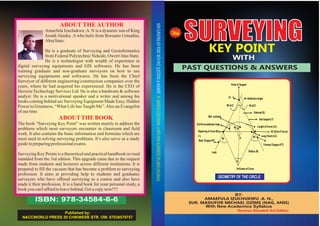
  • 1. SURVEYINGKEY POINT WITH PAST QUESTIONS & ANSWERS ISBN: 978-34584-6-6 With BY: AMAEFULA IZUCHUKWU .A. N., SUR. MADUFOR MICHAEL OZIMS (NAG, ANIS) With New Academics Syllabus Published by: NACCWORLD PRESS 29 CHIKWERE STR. OW. 07038579757 Reverse Standard 3rd Edition GEOMETRY OF THE CIRCLE 90 B D /2=Curve deflectionAngle 90 90 90- /2 EC (End of Curve) Sub tangent (T) = Deflection Angle External (E) Length of Curve (LC) Long Chord (LC) Forward Tangent (FT) Radius (R) Beginning of Curve BC Back Tangent BT PI V O=Center of Curve 0+00 Mid-ordinate Point of Tangent T1 90- /2 NEWSURVEYINGKEYPOINTWITHPASTQUESTIONS&ANSWERSBY:AMAEFULAIZUCHUKWU.AWITHNEWACADEMICESSYLLABUS(3rdEdition)
  • 2. i ii Preface This book Surveying Key point presents a classical approach in the field of surveying by providing a vivid insight into the theory and practical of surveying and its application through solving various problems in the field of surveying. Its depth and breadth also makes it ideal for self-study. It aims at helping students understand surveying more comprehensively through solving field related problems useful not only to Land Surveyors but also to all environmental and civil profession. A number of past questions and answers which are nowadays commonly used in many competitive examinations such as SURCON, COREN and NIQS/TPPC have been included on each topic to help the readers to get better score in such examinations. In keeping with the goal of providing an up-to-date presentation of surveying equipment and procedures, Total Stations are stressed as the instruments for making angular and distance observations. GPS is commonly used to establish controls, create maps, and lay out plans. EDM is used for making distance measurements only. Digital Levelling is used to determine the difference in height of points on the earth surface. The practicing Engineers and Surveyors will also find this book very useful in their career while preparing designs and layouts of various application-oriented projects. -Anih Francisca K (Surv) First Published 2012 Second Published 2013 Third Published 2015 Reversed Third Published 2017 Copyright © Amaefule Izuchukwu Alauku +2347064649087 +2348163991115 All right reserved. No part of this book may be reproduced by any means electronic or mechanical, including photocopying, recording taping or other information storage and retrieval system without the written permission ofAuthor and the Publisher. Printed by: Naccworld Printing Press @ 29 Chikwere Street Owerri, Imo State. 07038579757, 07038655576 Distributors are wanted Nation Wide. Contact the author @ Heroizu Technology Services Ltd Head Office HeroizuTech Complex, Off Nekede Poly Road, By 3Nity Junc., Nekede, Owerri, Imo State. Website:www.heroizutech.com.ng Blog Site: www.heroizutechng.blogspot.com.ng https://mypedagogue.blogspot.com.ng Phone: +2347064649087, +2348181554446, +2348163991115 Surveying Key Point With Past Question & Answers Surveying Key Point With Past Question & Answers
  • 3. DEDICATION This piece of inspired book is divinely dedicatedto GodTheFather, The Son, &TheHolySpirit. Also to my beloved parents Mr. & Mrs. King Josiah Alauku .A. U. and to my beloved brothers, King Ezieke, Ambassador Chidi, G o v e r n o r U c h e s o n , L i v i n g s t o n e Nwachukwu, Prince Kenneth and to my belovedsisterPrincessBlessing. iii iv FORWARDED Almost all surveying requires some calculations to reduce measurements into a more useful form for determiningdistance,earthworkvolumes,landareas, etc. At a glance, the book SURVEYING KEY POINT, is of theoretical and field importance having covered series of modern topics as taught with school academics syllabus in Monotechnics, Polytechnics and Universities offering surveying and geoinformaticsandaffiliates. The book provide answers to questions concerning surveying field problem from various angle with in- depth knowledge from his research work and field practices. Contains the basic information which surveyors need inachievingtheirdailytaskinthefieldofpractices. With the aforementioned, I recommend this Hand Book for students, lecturers, field practices surveyors and those writing their professional exams because of itssimplicityandcoverage. SURV. CHUKWU FEDELIS HOD, SURVEYING & GEOINFORMATICS FEDERALPOLYTECHNIC, NEKEDE OWERRI, IMO STATE, NIGERIA. Surveying Key Point With Past Question & Answers Surveying Key Point With Past Question & Answers
  • 4. ACKNOWLEDGMENT My first thanks goes to theAlmighty God who in spite of my nothingness and ingratitude initiated me to write this book. I will like to appreciate the effort of my friends, Surv. Olusegun Ayodapo .F, Miss Anih Fransica .K. (Surv.), Akpan Frank (Surv.), Maduabuchi anyanwu (Surv.), and Also to say thanks to all surveyors nationwide. Acknowledgement also goes to Surv. Obi (Okopoly), Surv. Ibedu Geo (HOD Unwanapoly), Surv. C. Fedelis (HOD Nekede Poly), Surv. R. O Asonibare (HOD Kwara Poly), Surv. R. U Odidika (MLH & UP, Imo State), to all YSN, NIS and SURCON Members and to all my lecturers within and outside the country who have made me what I am today. I am not forgetting the presence of the Redeemed Christian Church of God members, NIFES member, CASOR members and other fellowships for their help andsupport.MayGod blessyouallAmen. CHAPTER ONE INTRODUCTION…………………………....…….....…….1 HISTORICAL BACKGROUND OF SURVEY AND GEO- INFORMATICS…………………………...…..……....……1 W H Y T H E S T U D Y O F S U RV E Y I N G & G E O - INFORMATICS………................……………………...…..1 JOBS/CAREERS IN SURVEYING AND GEO- INFORMATICS ............................................................2 CHAPTER TWO What is SURVEYING………………………………...........…3 T Y P E S O F S U R V E Y I N G A N D I T ' S OBJECTIVES….............3 P U R P O S E A N D U S E S O F S U R V E Y I N G ……….......……….4 CHAPTER THREE BASIC PRINCIPLES OF SURVEYING QUESTIONS & ANSWERS ……………………………...…………............…9 CHAPTER FOUR FIELD ASTRONOMY PASTS QUESTIONS AND ANSWERS………………..……………………...………….5 8 CHAPTER FIVE CONTROL SURVEYING PASTS QUESTIONS AND ANSWERS……………............…………………………….. CHAPTER SIX ENGINEERING SURVEY PASTS QUESTIONS AND A N S W E R S ……………………………..….......................…63 E L E M E N T S O F S I M P L E v vi Surveying Key Point With Past Question & Answers Surveying Key Point With Past Question & Answers
  • 5. CHAPTER ONE INTRODUCTION HISTORICAL BACKGROUND OF SURVEY AND GEO- INFORMATICS Surveying has been an essential element in the development of the human environment since the beginning of recorded history (ca. 5000years ago) and it is a requirement in the planning and execution of nearly every form of construction. Surveying as a foundation discipline in Engineering, Environmental Sciences and Planning, provides training in the spatial location of the earth's features, providing in the process of the environmental information necessary for designing of engineering works, spatial planning, and land administration etc. The surveyor is not only a professional and academic Geoscientist but also must have a good knowledge of physics, mathematics and able to work in a multi-disciplinary team comprising the environmentalanalystsandplannersetc. W H Y T H E S T U D Y O F S U RV E Y I N G & G E O- INFORMATICS As the name implies, the Programme provides the theoretical knowledge and practical skills to create geographic information systems and to develop a scientific approach to the fundamental issues in respect of development and use of these systems. It is often used to establish land maps and boundaries for ownershiporgovernmentalpurpose. Since the problems a surveyor attempts to solve are of diverse nature, his education must be oriented accordingly. Therefore, surveying students must be well trained in the following areas: - Remote sensing, Geodesy, Hydrographic surveying, Photogrammetry and land surveying which includes Cadastral, Topographic surveying and engineering surveying. In the area of Geo-informatics, it helps in analytical, data collection andmanagementinourglobaldevelopmentsystem(Earth). JOBS/CAREERS IN SURVEYING AND GEO- INFORMATICS It has become a question to many parents who find their children studying this course, and also some of the student who find themselvesinthiscourseduetoadmissionfrustration. Because of this, these student are found not doing well in their exams and in their results, while some lack the basic fact (The practical aspect) that build up the course survey at the end oftheiryearofstudy.Theyarefoundnotbeensuccessfulinlife. As a survey student, you have to know that there are many job opportunities for you. When you become a graduate in this field. When you become a graduate and now pass through the SURCON/NIS exam, you will definitely become a registered surveyor nationwide. As a surveyor, you can carry out any survey contract anywhere within and outside the country and evenacross internationalboundaries. Some of the opportunities for you as a surveyor are numerous and you are required for employment in the following sectors:- Oil and Gas, Mining Industries, Construction Companies, Navigation Services, Private Practice, Academic Sectors as Lecturers, Staff etc, Civil engineering consulting Officersandmanyothers. Now you have known some of the places you can find yourself as a surveying and geo-informatics student, all you have to do now is to involve yourself in every practical and assignment given to you. This will help you to understand the course and at the end of every exam, you will come out with a goodresultbothinpracticalaspectandintheories. THE QUALIFICATION OFASURVEYING STUDENT Surveying is a professional course leading to the Bachelor of Science (Bsc) orTechnology orientation through the polytechnic leading to Higher National Diploma (HND). It is obtained on 5years standard schedule or a maximum of in for four(4)yearsthroughdirectentryintotheuniversity. Page 1 Page 2 Surveying Key Point With Past Question & Answers Surveying Key Point With Past Question & Answers
  • 6. CHAPTER TWO SURVEYING what is Surveying Surveying is the art, science and technology of obtaining angular and linear measurement, using them direct and indirectly to calculate the data which are then plotted to show the size, position and slope of a portion. Also, Surveying is the art and science of measuring distances, direction and elevation to determine the relative positions of features on the earth's surface andtheirrepresentationintheformofmaps,plansandcharts. TYPES OFSURVEYINGAND IT'S OBJECTIVES Therearetwomaintypesofsurvey. 1. Geodetic Surveys: Are precise and over large areas requiring the curvature of earth to be considered. Distances andanglemeasurementsmustbeveryaccurate.While 2. Plane Surveys: It is the survey which considers the surface of the earth to be a plane. Curvature is ignored and calculations are performed using the formulas of plane trigonometry and the properties of plane geometry. These maybeconsideredaccurateforlimitedareas. Branchesof Surveying 1. Engineering Surveys: It is a survey which involves the collection of data that is needed to plan and design engineering projects. The information ensures the necessary position and dimension control on the site so that thestructureisbuiltintheproperplaceandas designed. 2. Route Survey: They are necessary for the design and construction of various engineering projects such as roads, railways,pipelines,powerlinesandcanals. 3. Topographic Surveys: Survey that are performed to gather data that are necessary to prepare topographic maps. These are multi-colour contour maps portraying the terrain, and rivers, highways, bridges and other man- madefeatures. 4. Mine Survey: It is a survey that determine the position of underground works such as tunnels and shafts, the positionofsurfacestructuresandthesurfaceboundaries. 5. Industrial surveys, or Optical Metrology: Are survey used in the aircraft and other industries where very accuratedimensionallayoutsarerequired. 6. Hydrographic Surveys: It is a survey that is used to map the shorelines of bodies of water; chart the bottom of streams, lakes, harbour and coastal water, measure the flow of rivers; and assess other factors affecting navigation and water resources. The sounding of depths byradarisinvolvedinthistypeofsurvey. PURPOSEAND USES OFSURVEYING The main purpose of surveying is to produce a surveying plan, chartormap. Uses ofSurveyingplanare: 1. For theregistrationoftitle 2. For obtaining the certificate of occupancy (C of O) of a parcelofland. 3. For landtransactions 4. For planningofvariousdevelopmentsonland 5. For settlinglanddisputecasesincourts. Theprocesses ofexecutingasurveyplan Survey traverse work involves several basic steps to plan and execute. i. researchingexistingcontrolintheprojectarea ii. designsurveytomeetspecifications iii. determinetypesofmeasurements Page 3 Page 4 Surveying Key Point With Past Question & Answers Surveying Key Point With Past Question & Answers
  • 7. iv. determinetypesofinstruments v. determinefieldprocedures vi. sitereconnaissanceandapproximatesurveys vii.installmonumentsandtraversestations viii. datacollection ix. datareduction x. dataadjustment xi. preparesurveyreport xii.Submissionofthefieldwork WHAT IS TRAVERSING TraverseSurvey This is a method of surveying in which a frame work of traverse is establishedinthefieldtobesurveyed. Types ofTraversing 1. Chain Traversing: It may be accomplished with chain as theprincipalmeasuringdevice. 2. Compass Traversing: It may be accomplished with compassastheprincipalmeasuringdevice. 3. Plane tabling Traversing: It may be accomplished by plotting the traverse in accordance with the procedure for planetablesurvey. 4. Theodolite Traversing: Theodolite is employed by taking observationsforplottingthetraverse. 5. Tachometric Traversing: Here the traverse is plotted with thehelpoftachometricobservations. To accomplish traversing, both the linear and angular measurements are necessary. On like chain survey that is based on triangulation i.e. can be accomplished with linear measurements only. Importanceoftraversingincludes: 1. Todeterminethepositionsofexistingboundarymarks. 2. Toestablishthepositionsofboundarylines. 3. To establish control for locating rail roads, high ways and otherconstructionwork. 4. To establish ground control for photogram metric mapping. 5. To determine the positions of arbitrary points from which data may be obtained for preparing various type of maps, i.e.toestablishcontrolformapping. 6. To determine the area encompassed within the confines ofaboundary. Reconnaissance It is the first step to be carried out when surveying or setting outanewsite.Itinvolvesthefollowing:- 1. To determine suitable field processes and to select equipmentandmaterials. 2. To locate existing survey control point to connect plan andlevel. 3. Toplantcontrolstationpositions. 4. Toplanthecorrelationbetweencontrolanddetailwork. 5. Toassess potentialproblemse.g.obstacles. 6. Toinvestigatelandownershipandaccess. 7. To ascertain the importance of man-made features such as roads,structuresandservices. BasicPrinciplesofSurveying These are rules and regulation guiding the practice of Surveying in order for our results/readings to be accurate and precise. 1. TheprincipleofcontrolorWhole-To-Part. Here the surveyor is expected to establish the location, area,boundariesetc.beforehiswork willbeaccepted. Page 5 Page 6 Surveying Key Point With Past Question & Answers Surveying Key Point With Past Question & Answers
  • 8.  Control point: This is the starting point or reference point to which a survey is connected to. Co-ordinate of points tellsyouhow farthepointisfromtheoriginalpoint.  Whole-To-Part: “Whole” is the perimeter of the survey plan or the enclosure that define the whole area while “To part” means fixing in the features (details) within the parcel oflandonehassurveyed/measured. 2. EconomyofAccuracy: This means that you should be very careful when surveying i.e. following this rules and regulation of survey. This can save time, material, money etc. In other words it means using sophisticated material when the need arise and instrumentofloweraccuracywhentheneedalsoarise. 3. WorkingConditions  When the sunshine is to intense close/end your work because reflection of light can deviate you from the main point.  Whenitisrainingstopyourwork.  Whenyouaretired.  Disturbanceofmosquitoes. 4. Independent Check: Thisreferstomeasuringalengthbothfromthefrontand backwardandcheckifthetworesults/readingsarethe same.Sometimesformula(Zn+4)rightangle(For externalAngle)or(zn-4)rightanglefor(Internalangle). Insummary,independentcheckinvolvescheckingof calculations/computationmanytimestoavoiderror. 5. Consistency: Here the equipment or instrument you are using should not be too sophisticated or too low for the precise value of yours measurement i.e. the degree of carefulnessshouldmatchtheaccuracyofthejob. 6. Safe guarding: This means keeping records that are durable or marks that will last to safeguard pillars or land beacon made by a surveyor for future references. Also using inks/pen that will not wipe away easily to write our computations. 7. Revision: This means to re-survey a particular prepared survey to remove features that are no longer in existence andaddthosenewfeaturesonthenewsurveyplan. PROCEDURE FOR RUNNING A TRAVERSE To begin any traverse, a known point must be occupied. (To occupy a point means to set up and level the transit or theodolite, directly over a monument on the ground representing that point.) Next, a direction must be established. This can be done by sighting with the instrument a second known point, or any definite object, which is in a known direction from the occupied point. The object that the instrument is pointed to in order to establish a direction is known as a backsight. Possible examples would be another monument on the ground, a radio tower or water tank on a distant hill, or anything with a known direction from the occupied point. A celestial body such as Polaris or the sun could also be used to establish an initial direction. Once the instrument is occupying a known point, for example point number 2, and the telescope has been pointed toward the backsight, perhaps toward point number 1, then an angle and a distance is measured to the first unknown point. An unknown point being measured to is called a foresight. With this data, the position of this point (let's call it point number 100) can be determined. The next step is to move the instrument ahead to the former foresight and duplicate the entire process. Page 7 Page 8 Surveying Key Point With Past Question & Answers Surveying Key Point With Past Question & Answers
  • 9. ProcedureforReducing and Computation ofFieldData nd st 1. 2 leftminus(-) 1 left= HorizontalRight. st nd 2. 1 rightminus(-)2 right= HorizontalRight. nd st 0 3. If2 leftis less than1 left,add360 …. st nd 0 4. If1 rightisless than2 right,add360 Togetforwardbearing,addassumemeantotheangle 0 and subtract360 . 0 For backward bearing, add 360 to the FB. When given assume mean,(FB)add180to FB togetthe BB ofdassumemean. st 1 Stn= BB ofAm+Angle–360= FB, FB +180= BB. nd st 2 Stn= BB of1 Stn+Angle–360= FB, FB +180= BB Methods ofMeasuringHorizontalDistances 1. Placing: - This is an approximate method of measuring distances. 2. Odometer: - An odometer converts the number of revolution of a wheel of a known circumference to a distance. 3. Tachometry: - Here, distance is not measured directly but indirectly with the help of an optional instrument called tachometer. 4. Electronicdistancemeasurement(EDM) 5. Chains: - are used to measure distances when very great precisionsarenotrequired. 6. Tape.  There are fourmain methods used in fixing the position of apointonthehorizontalplane. 1. By triangulation from two points whose positions are already fixed and known. 2. By bearing and distance from a single fixed point. 3. By offset from a chain line. 4.Byresection. Traverse Computation The various steps in traverse computation will now be carried out, with reference to the traverse field procedure. The observed horizontal angles and distances are explained below. A common practice is to assume coordinate values for a point in the traverse, usually the first station, and allocate an arbitrary bearing for the first line from that point. For instance, point A has been allocated coordinates of E 1000.00, N 2000.00, and line AB a bearing of 0◦ 00’ 00’’. If values of E 0.00, N 0.00 had been chosen there would have been negative values for the coordinates of some of the stations. Negative coordinates can be confusing. This has the effect of establishing a plane rectangular grid and orientating the traverse on it. As shown, AB becomes the direction of the N-axis, with the E-axis at 90◦ and passing through the grid origin at A. The computational steps, in the order in which they are carried out, are: (1) Obtain the angular misclosure W, by comparing the sum of the observed angles (α) with the sum of error-free angles in a geometrically correct figure. (2) Assess the acceptability or otherwise of W. (3) If W is acceptable, distribute it throughout the traverse in equal amounts to each angle. (4) From the corrected angles compute the whole circle bearing of the traverse lines relative to AB. (5) Compute the coordinates (ɵE, ɵN) of each traverse line. (6) Assess the coordinate misclosure (ɵE, ɵN). (7) Balance the traverse by distributing the coordinate misclosure throughout the traverse lines. (8) Compute the final coordinates (E, N) of each point in the traverse relative to A, using the balanced values of ɵE, ɵN per line. Page 9 Page 10 Surveying Key Point With Past Question & Answers Surveying Key Point With Past Question & Answers
  • 10. Page 11 Page 12 The above steps will now be dealt with in detail. (1) Distribution of angular error: The majority of the systematic errors associated with horizontal angles in a traverse are eliminated by repeated double-face observation. The remaining random errors are distributed equally around the network as follows. In a polygon the sum of the internal angles should equal (2n−4)90◦, the sum of the external angles should equal (2n + 4)90◦. n ∴ Angular misclosure = W =Σ ai − (2n ± 4)90◦ = −50"1 =1 Where α = observed angle n = number of angles in the traverse. The angular misclosure W is now distributed by equal amounts on each angle, thus: Correction per angle = W/n = +10" However, before the angles are corrected, the angular misclosure W must be considered to be acceptable. If W was too great, and therefore indicative of poor observations, the whole traverse may need to be re-measured. Example 6.3 The coordinates of A, B and C (Figure 6.27) are: EA 1234.96m NA 17 594.48m EB 7994.42m NB 24 343.45m EC 17 913.83m NC 21 364.73m Observed angles are: APB = α = 61◦ 4’ 46.6" BPC = β = 74◦ 14’ 58.1" Find the coordinates of P. (1) From the coordinates of A and B: ɵEAB = 6759.46, ɵNAB = 6748.97 ∴ Horizontal distance AB = √(ɵE2 + ɵN2) = 9551.91m Bearing AB = tan−1 (ɵE/ɵN) = 45◦ 02’ 40.2" (or use the R→P keys on pocket calculator) (2) Similarly from the coordinates of B and C: ɵEBC = 9919.41 m, ɵNBC = −2978.72 m ∴ Horizontal distance BC = 10 357.00 m Bearing BC = 106◦ 42’ 52.6" From the bearings of AB and BC: C ˆBA = φ = 180◦ 19’ 47.6" Surveying Key Point With Past Question & Answers Surveying Key Point With Past Question & Answers
  • 11. CHAPTER THREE SURVEYING QUESTIONS & ANSWERS 1. Qs. list and explain the three reference axes of a total station? Ans. 1. Theaxisofsightorlineofsight 2. Thehorizontalaxisand 3. Theverticalaxis. 2. Qs.Whenwillyouapplyparallaxintotalstation? Ans. Parallax method is applied when the focusing of the two lensesis notcoincident. 3. Qs.Explainwhatisparallaxcorrectionintotalstation? Ans. Parallax is the apparent motion of an object caused by a movementinthepositionoftheobserver's eye. 4 Qs. Enumerate at least, six functions of contour lines embeddedinatopographicplan? Ans. NOTE: A contour is a line connecting points of equal elevation.They are lines drawn on a plan; it is also, a line on amapjoiningpointsofsimilarelevation THE FUNCTIONS OFCONTOUR LINES 1. Surveyors and engineers most often use contours to depict relief. 2. On maps, contours represent the planimetric locations of thetracesoflevelsurfacesfordifferentelevation. 3. The distance between contours indicates the steepness of slope. While separation denotes gentle slopes; close spacing. 4. Irregular contours signify rough, rugged country. Smooth linesimplymoreuniformlyrollingterrain. 5. Concentric closed contours that increase in elevation representhills. 6. Contours are perpendicular to the direction of maximum slope. 5. Qs.DifferentiatebetweenTachometerandTachometry? Ans. Tachometer: it is a vernier theodolite fitted with stadia diaphragm. It has three horizontal hairs, one central and othertwoequidistantfromcentralhair.While. Tachometry: is a rapid and economical surveying method by which the horizontal distances and the differences in elevation are determined to scale using angels observed with a transit or thetheodolite. 6. Qs. Distinguish between planimetric and topographic maps? Ans. Planimetric maps: they are scaled maps showing the scaled horizontal locations of both natural and cultural features.Itis alsocalled“Ortho-photomaps” WhileTopographicmap:isthemapshowing spotelevations andcontours. 7. Qs. features represented in topographic maps are either naturalorartificial.Nameanythreeofeachcase Ans. Natural features includes: stream banks, rock, trees, rivers, etc. while Artificial features includes: buildings, railwaytracks,bridgesandpipelines. 8. Qs.Listfivecharacteristicsofcontours? Ans.1.Closelyspacedcontoursindicatesteepslopes 2. Widelyspacedcontoursindicatemoderateslopes 3. Contoursmustbelabeledtogivetheelevationvalue. Page 13 Page 14 Surveying Key Point With Past Question & Answers Surveying Key Point With Past Question & Answers
  • 12. 4. Contoursarenotshown goingthroughbuilding. 5. Contourlinescannotbeginorendontheplan. 6. Theycannotcross eachother. 9.Qs.Whatis mapscale? Ans. Map scale is the ratio of the length of an object or feature onamaptothelengthoftheobjectorfeature. 10.Qs. Give three ways which scales can be represented with examples Ans. MapScalecanberepresentedby 1. Byratioorrepresentativefractionsuchas1:2000or1/2000. 2. Byanequivalence,forexample,1in=200ft. 3. By graphically using either a bar scale or labeled grid lines spacedthroughoutthemapatuniformdistancesapart. *And also, map scales may be classified as large, medium, and small.Therespectivescalerangesareasfollows. 1. Largescale,1in.=200ft(1/2400)orlarge 2. Medium scale, 1in. = 200ft to 1in. = 1000ft (1:2400 to 1:12,000) 3. Smallscale,1in.=1000ft(1:12,000)orsmall. *AreasofApplication. 1. Large scale are applied where relatively high accuracy is needed over limited areas; for example, in subdivision design and the design of engineering projects like roads, dams,airportsetc. 2. Medium scale are often used for applications such as general preliminary planning where larger areas are covered, but only moderate accuracy is needed. E.g. mapping the general layout of potential construction sites; proposedtransportationsystems. 3. Small scale maps are commonly used for mapping large areas where a lower order of accuracy will suffice. They aresuitableforgeneraltopographiccoverage. Page 15 Page 16 BASIC PRINCIPLES IN SURVEYING 11. Qs. Explain what is meant by the term “Working from the WholetoPart”? Ans. The term “Working from the Whole to Part” is the principle of laying down overall system of stations whose positions are fixed to a high degree of accuracy. It is the principle of working from the area of higher concentrationtotheareaoflowerconcentration. 12.Qs.Distinguishbetweenplaneandgeodeticsurvey? Ans. In plane survey, the area of interest is taken to be a horizontal plane and measurements plotted will represent the projection on the horizontal plane of the actual field measurements. While, in geodetic surveying, the curvature of the earth is taken into consideration and the knowledgeofsphericalgeometryis needed. 13. Qs. List any three methods of making linear measurements? Ans. (1) By using tape (2) By Optical means, and (3) By using ElectronicsDistanceMeasurement(EDM) 14. Qs.Nameandexplainanyfourbranchesofsurveying? Ans. (a) Cadastral Surveys: this is carried out in order to define boundariesofproperties,legislativeareasandcountries. (b) Geodetic Surveys: this is carried out at the national level to provide controls to which future surveys can be based. Here,ahighdegreeofaccuracyisrequired. (c) Topographic surveys: this involves the measurement of the physical features of the earth to produce map and plan showing their relative positions both horizontal or vertically. (d) Engineering surveys: this supplies details for particular engineering works and could include the setting out Surveying Key Point With Past Question & Answers Surveying Key Point With Past Question & Answers
  • 13. works onground. 15a.Qs.Belowaremeasurementsmadeoncorners. (a)Pointsoffivesidedpieceofland *CalculatetheAreainhectares,usingHero's formula. Ans. SOLUTIONS NB:methodsofAreaCalculationsare: (i) By hero's formula (ii) By double meridian method, and (iii)ByCross Coordinatemethods But for irregular figures, the following methods can be employed: (a) Simpson's rule (b) Prismoidial formula (c) Mid- ordinateand(e)Average-ordinaterule. But our emphasis is on the methods for Area of regular figures whichareusedinthismonograph. AreabyHero'sformula. A=√s(s –a)(s –b)(s-c) Wheres =a+b+c 2 2 For θ ABC S=40.00+50.000+20.000=110.00/2=55.00 Page 17 50.00 20.00 40.00 C E20.04 30.00 60.00B 50.00 D A b c a 50.0020.00 40.00 Surveying Key Point With Past Question & Answers Page 98 Surveying Key Point With Past Question & Answers
  • 14. 2 A=√55.00(55.00-40.00)(55.00–50)(55.00-20) =√55.00(15.00)(5.00)(35.00)=√55.00(2625) A=√144375.00=380.00m²ans. Forθ ACE S=50+60+20.004 2 =130.004=65.002; A=√65.002(65.002–50)(65.002–60) 2 (6.002–20.004) A=√65.002(15.002)(5.002)(44.998) A=√219489.010 A=468.497m²Ans. Forθ CDE S=60+30+50 2 S=140/2=70Ans. A=√70(70-60)(70-30)(70-50) A=√70(10)(40)(20) A=√560000 A=748.331m²Ans. Totalarea=380.000+468.497+748.331 TotalArea=1596.828m² InhectaresArea=1596.828m²/10,000=0.160Hectares Qs. 15b. List any five corrections to be applied to a measured line PQ tobringittoacorrectedhorizontaldistance. Ans. Corrections to be applied to a measured line to bring it to a correctedhorizontaldistanceare: 1) Slope correction 2) Temperature correction 3) Sag correction, 4)Tensioncorrection5)Standardizationcorrection. 16a. Qs. Calculate the corrections to be applied in each of the following cases to bring the slope distance to horizontal distances. Hence or otherwise calculate the respective horizontal distances? (i) Aslopedistanceof100matanangleofslopeof9˚30' (ii) A slope distance of 600m where the difference in height betweenthetwoendsofthestationis20.928m. SOLUTION Ans. (i) H = S Cosθ Where H = horizontal distance S = Slope distance. Θ = Angle of slope H = 100 cos9˚ 30' H = 98.629m. From here, correction C = 100 – 98.629 = 1371m. This ischeckedthus C=L(1-cosθ) =100(1-cos90˚30'=1.371mAns. (ii) heightdifference=20.928m Slopedistance =600m Correctionx=h²/2L x=20.928² =437.981 =0.365mAns. 2x600 1200 Page 18 Page 19 60.00 50.00 A’ 20.04 E C E C D 30 50 60 9˚3 100 m H Surveying Key Point With Past Question & Answers Surveying Key Point With Past Question & Answers
  • 15. Therefore;H =600–0.365 H =599.635m.Ans 16b. Qs. After completing a survey, the 100m tape used was checkedandfoundtobe100.014mlong. (i) Calculate the correct length of a line measured as 450.00m withtheincorrecttape. (ii) If the area of land surveyed with the incorrect tape is 7.182 hectares,calculatethecorrectareaoflandsurveyed. SOLUTION Norminallengthoftape=100m Reallengthoftape=100.014m Measuredlength =450.00m Norminalarea=7.182hectares (i) Norminallengthoftape =measuredlength Reallengthoftape reallength  100 = 450 100.14P 100P=45000.3 P=450.063m.Ans. (ii) (Norminallengthoftape)²= Norminal (Reallength)² A  100² =7.182 100.014² A =>A=71840.111 10,000 A=7.184HectaresAns. 17. Qs. You are required to carry out a chain survey of a section of the Polytechnic football field. Give a step by step description on how you can accomplish the task, indicating the minimum man-power and equipment required for executingtheproject. Ans. Chain survey of a section of the Polytechnic football field. Step one: Reconnaissance: Recall that every type of survey begins with a recce which helps the surveyor to farmilarize himself with the area of interest. It is after the recce that the surveyor determines the number of man power and equipment to useforthesurvey. Man-power i. thesurveyor ii. thechainmanand iii. 3 other assistance. This is the minimum man-power for thesurvey. Equipments i. chainortape, ii. Abneylevelformeasuringslopeangle(ifany) iii. Rangingpolesforranging/settingoutstraightlines iv. The cross staff & Optical square for right angle setting out. Step two. Measurement: Note, chain surveying is carried out by usinglinearmeasurementonly. Here, the distances of the section are measured starting from the longest leg of the section (base line). After completing the perimeter measurement, the diagonals of the section is also measuredinaddition. Step three; Presentation:it is well known that the end-productof any survey is plan/map. Here, the plotting is done using the base line and the diagonals as a guide. This is done on a cartridge paperbasetoshow theareaundersurvey. Page 20 Page 21 Surveying Key Point With Past Question & Answers Surveying Key Point With Past Question & Answers
  • 16. SUG/102 18. Qs. In order to determine the depth at various points in a lake, a surveyorobtainedthefollowinglevelingdata,from b e n c h mark BM1to BM2. If the reduced level of change CH0 + 000 is 100.000m above MSL. Compute the leveling data of other points using any method.Applyallnecessarychecksandcorrectionsifpossible. ANS. SOLUTION USING HEIGHT OFCOLLIMATION METHOD 1(a) ∑BS-∑FS = 9.904- 9.910 = - 0.006 RLBM2 – RLBM1 = 99.994 – 100.000 = - 0.006 :. Misclosure = - 0.006 Correction = Misclosure x individual distance Total distance NB: since the Misclosure is negative, correction will be positive.st For 1 change: c = 0.006 x 20 = 0.0008 = +0.001 B.S I.S F.S REMARK 1.510 - BM1 (CH0+000) 1.520 1.425 C.P1(CHO+020) 1.541 PointA 1.540 1.528 C.P2 [CH0+040] 1.335 Point B 1.325 1.520 C.P3 [CH0+060] 1.498 Point C 1.305 1.349 C.P4 [CH0+080] 1.473 Point D 1.335 1.250 C.P5 [CH0+100] 1.280 Point E 1.369 1.429 C.P6 [CH0+120] 1.409 BM [CH0+140] [TOP OF BM2] BS IS FS HI UNCORRE CTED RL (m) CORR N CONFIDEN TIAL RL(m) REMARK 1.510 - - 101.5 10 100.000 _ 100.000 BM1(CH0+000) 1.520 - 1.425 101.6 05 100.085 +0.001 100.035 CP1(CH0+020) 1.541 - 100.064 +0.001 100.065 PtA 1.540 - 1.528 101.6 17 100.077 +0.002 100.079 CP2(CH0+040) 1.335 100.282 +0.002 100.284 PtB 1.325 - 1.520 101.4 22 100.097 +0.003 100.100 Cp3 (CH+060) 1.498 99.924 +0.003 99.927 ptC 1.305 - 1.349 101.3 78 100.073 +0.003 100.076 CP4(CH0+086) 1.473 99.905 +0.003 99.908 ptD 1.335 - 1.250 101.4 63 100.128 +0.004 100.132 CP5(CH0+100) 1.280 100.183 +0.004 100.187 P7E 1.369 1.429 101.4 03 100.034 +0.005 100.039 CP6(CH0+120) 1.409 99.994 +0.006 100.000 BM2(CH0+140) ∑=9.90 ∑ 9.9104 Page 22 Page 23 Surveying Key Point With Past Question & Answers Surveying Key Point With Past Question & Answers
  • 17. CHECKS RL+ BS = HI HI – FS = RL HI - IS = RL ∑BS -∑FS = RLBM2– RLBM1Ans. USING RISEAND FALLMETHOD CHECKS ∑BS =∑FS =-0.006 ∑Rise- ∑fall=0.730 –0.736=-0.006 RL – RL =-0.006Ans.BM2 BM1 19a(ii) Sketchthesection Ans. 100 DATUM 20 40 60 80 100 120 140 0.000 NOTE:Thesketchis nottoscale. (b) Qs. State the precautions which should be carried out on the fields during a leveling exercise in order to eliminate or minimizeerrors. Ans. Precautions on leveling: In order to eliminate or minimize errors in leveling,thefollowingprecautionsmustbecarriedout. (i) Ensuretheverticalityof thestuff (ii) Instrumentshould notbeseton avibratingground (iii) Ensure that the instrument is leveled before talking any reading. (iv) Leveling should not be done under a hot sun to avoid refraction. (v) Levelingshould notbecarriedoutunderrain (vi) The tripod which the instrument is mounted must not be touched after the instrument has been leveled to avoid dislevelment. (vii) At every change point, the staff man must not move the staff from the base but only turn the face of the staff to face theinstrument. BS IS FS RISE +ve FALL -ve Uncor. RL Cor. Final RL Remark 1.510 - - 100.000 - 100.000 Bm1(CH0+000 1.520 1.425 0.085 100.085 +0.001 100.000 CP1(CH0+020 1.541 0.021 100.064 +0.001 100.065 PtA 1.540 1.528 0.013 100.077 +0.002 100.079 CP2(CH0+040) 1.335 0.205 100.282 +0.002 100.284 PtB 1.325 1.520 0.185 100.097 +0.003 100.100 CP3(CH0+060) 1.498 0.173 99.924 +0.003 99.927 PtC 1.305 1.349 0.149 100.073 +0.003 100.076 CP4(CH0+080) 1.473 0.168 99.905 +0.003 99.908 PtD 1.335 1.250 0.223 100.128 +0.004 100.132 CP5 1.280 0.055 100.183 +0.004 100.187 PtE 1.369 1.429 0.149 100.034 +0.005 100.039 CP6(CH0+120) 1.409 0.04 99.994 +0.006 100.000 BM2(CH0+140) ∑=9.904 ∑=9.9 10 ∑=0.7 30 ∑=0.7 36 Page 24 Page 25 Surveying Key Point With Past Question & Answers Surveying Key Point With Past Question & Answers
  • 18. Qs 20a A B D C The above figure ABCD is a braced quadrilateral with eight angles observed in a mirror triangulation scheme. State ALL the angle conditionstobesatisfiedintheadjustmentofeightangles. Ans. SOLUTION 2a. BRACE QUADRILATERAL In the adjustment of the eight angles of the brave quadrilateral above, the followingconditionsmustbeobserved. (i) Sumofoppositeanglesareequali.e. 1+2 = 5+6 3+4 = 7+8 0 (ii) 1+2+3+4+5+6+7+8 =360 (iii) Products ofsins of odd angles =1 Products ofsins of evenangles N/B:Sumoftheinteriorangle=(2n-4) 90. Qs.( 20b)(i) If the eight angles observed in the triangulation scheme (Bracedquadrilateral)shown abovearegivenas follows: 1 8 2 3 4 5 7 6 Use the angle conditions stated by you to obtain only the firstadjustedvaluesoftheangles. Solution: b(i)The8anglesofthequadrilateralaregivenasfollows: 360.00 10 -3600000 00 00 10” =,Misclosure=10” Correction=10” 0 8 =00 00' 1.25” ANGLES OBSERVED VALUE 1 52 0 201 44” 2 540 191 46” 3 400 221 55” 4 320 561 41” 5 500 201 40” 6 560 191 56” 7 300 531 29” 8 420 251 59” ANG LE OBSER VED VALUES ADJUSTM ENT TO 360 ADJUSTM ENT TO OPPOSITE < FRIST ADJUSTM ENT VALUE 1 52 20 44 -1000 00’1.25’ +00 00 1”.5 520 20’ 44.25” 2 54 19 46 -000 00’1.25’ +00 00’ 1.5” 52 20 46.25 3 40 23 55 " -00 0004” 40 22 49”.75 4 32 56 41 " -00 00 04” 32 56 35.75 5 50 20 40 " -00 00 1”.5 50 20 37.25 6 56 19 56 " -00 00 1”.5 56 19 53.25 7 30 53 29 " +00 00 04” 30 53 31.75 8 42 25 59 " +00 00 04” 42 26 1.75 ∑ 360 00 10” Page 26 Page 27 Surveying Key Point With Past Question & Answers Surveying Key Point With Past Question & Answers
  • 19. SincetheMisclosureis +ve,correctionbecomes–ve. ThisamountofMisclosureof1.25”isappliedtotheeightangles. For adjustmenttooppositeangles 1+2=52 20 44 +54 19 46 106 40 30 5+6=50 20 40 +56 19 56 0 0 Misclosure=106 40' 36”–106 4' 30” 0 =00 00' 06” 0 0 Corn=00 00' 06”/4=00 00' 1.5” Therefore since K1 & 2 is less than 5 & 6, it carried +ve correction whilethelatercarries–vecorrn 3+4=40 22 55 +32 56 41 73 19 36 7+8=30 53 29 +42 25 59 7319 28 Misclosure=731936–731928 0 =00 00 08” 0 Correction=00 00' 08” 0 4 =00 00' 04” :.Since7+8isless than3+4,it Carriesa+vecorrnwhilethelater Carriesa–vecorrnof4” Qs 20b(ii) ProvethatProductofsineofoddangles= 1 Productofsineofevenangles. Toshow that: (ii) Productsofsins ofodds Productofsuns ofeven<s =1 sin1xsin3xsin5xsin7 = sin 522044 x sin 402255 x sin 502040xsin305329 sin2xsin4xsin6xsin8 sin541956 x sin325641 x sin561956xsin422559 =0.20275 = 0.8172 1 0.24809 :.Productsofsins ofodds =1 Productsofsins ofevens 21(a) Below are the coordinates of the corner points of four (4) sidedpieceof LAND. ComputetheAREAinhectares Solution: Areacal.usingcross coordinates PILLAR NOS EASTINGS (M) NORTHINGS (M) SC/IMB 9970 503705.674 163127.593 SC/IMB 9971 503655.762 163162.591 SC/IMB 9972 503664.512 163175.070 SC/IMB 9973 503714.424 163140.071 Pillar Nos Eastings (m) Northings (m) A B SC/IMB9970 503705.674 163127.593 83670.641 SC/IMB9971 503655.762 163162.591 114,736.241 108043.671 SC/IMB9972 503664.512 163175.070 114840.253 125074.210 SC/IMB9973 503714.424 163140.071 93078.860 98844.463 SC/IMB9970 503705.674 163127.593 91,155.501 = 413774.855 = 415632.985 Page 28 Page 29 B–A=415632.985-413774.855=1858.13 2Area=1858.130 Area=1858.130 =929.065sqr meters 2 :.Area=929.065 =0.093 Hectares 10000 Areacalby doublemeridianmethod Surveying Key Point With Past Question & Answers Surveying Key Point With Past Question & Answers
  • 20. Doublingthelongitude -49.912x34.998= -1746.820 x 2 -99.824 +8.750 -82.324 +49.912 -32.412 x-34.999= +1134.388 +49.912 +17.500 - 8.750 8.750x-12.478=-109.183 -8.750 00 2A=-1857.763 Ignoringthenegativesign. 2A=1857.763 2 A=1857.763 =928.882m 2 2 :.Area=928.882m /10,000= 0.093Hectares (b) 21Qs. Fromtheinformationoncoordinatesshown above. (i) Calculate the bearing from SC/IMB 9970 to SC/IMB 9971. (ii) Calculate the bearing from SC/IMB 9971 to SC/IMB 9970 (iii) Calculate the distance from SC/IMB 9970 to SC/IMB 9971 i. Bearingfrom SC/IMB 9970–9971 ∆N =34.998 ∆E=-49.912 tan =∆E ∆N -1 =tan ∆E ∆ N -1 =tan 49.912 34.998 -1 =tan 1.42614 0 1  =054 57 44” Referringtosurveychart E N W ∆N+ ∆E- ∆E ∆N ∆N+ α=brg ∆E+ ∆N+ ∆E- S th Sinceitfallsonthe4 quadrant 0 1 brg=3600–54 57 44” 0 1 :.brg=from SC/IMB9970–9971=305 02 16” 0 1 0 (ii) Bankbearing=305 02 16”-180 0 1 =125 02 16” 2 2 (iii) Distance=√∆E +∆N 2 2 =√49.912 +34.998 =√3716.068 =60.960m Qs. 22(a) Area cal by double meridian method E N Easting North Pillar Nos 503705.674 163127.593 SC/IMB9970 -49.912 34.998 503655.762 163162.591 9971 8.750 12.475 503664.512 163175.070 9972 49.912 -34.999 503714.424 163140.071 9973 -8.750 -12.478 503705.674 163127.593 9970 Page 30 Page 31 Surveying Key Point With Past Question & Answers Surveying Key Point With Past Question & Answers
  • 21. B C A D The above figure ABCD is a braced quadrilateral with eight angles observed in a minor triangulation scheme. State All the angle conditionstobesatisfiedintheadjustmentoftheeightangles. Solution: (a) (i) For externalangles =(2n+4)90 Wheren =no of stns 0 1 =(2(4)+4)90=1080 00 00” 1 0 Error=1080 01 40”–1080 0000 0 1 =00 01 40” 1 Correction=0001 40”=25” 4 Thisamountissubtractedfromtheangles (ii) To checkforallowableMisclosure,30 “√n =30 “√4 0 1 =30”x 2 =00 01 00” 0 1 0 The error = 00 01 40” but allowable Misclosure for the survey is 00 1 01 00”. Since the error is more than the allowable Misclosure by 40”, theMisclosureis notallowable. But if the Misclosure s allowable, it can be corrected as shown in the tableabove. 22(b) If the eight angles observed in the triangulation scheme (Bracedquadrilateral)shown abovearegivenas follows: Using the angle conditions stated by you, obtain only the first adjustedvaluesoftheangles. Solution: STATION OBSERVED ANGLE MEASURED LINE/HORIZONTAL DISTANCE A 272 0 521 10” AB = 180.297M B 2960 431 18” BC = 164.583M C 2620 131 11” CD = 106.267M D 2480 131 01” DA = 112.615 STATI ON OBSERV ED ANGLE HD CORRECTI ON CORRECT ED ANGLES STATI ON TO A 272 23 10 180.2 97 - 25” 272 51 45 B B 296 43 18 164.5 83 - 25” 296 42 53 C C 262 13 11 106.2 67 - 25” 262 12 46 D D 248 13 01 112.6 15 - 25” 248 12 36 A  = 10800 01’ 40” Angles Observed value 1 600 28’ 50” 2 420 28’ 23” 3 360 38’ 49” 4 400 23’ 39” 5 450 45’ 41” 6 570 11’ 48” 7 380 15’ 20” 8 380 47’ 00” Page 32 Page 33 Surveying Key Point With Past Question & Answers Surveying Key Point With Past Question & Answers
  • 22. To determine the not observed to C, the difference between the 0 faceleftandfacerighttoCshouldbe180 0 0 :.notobserved=293 39' 34”–180=113 39' 34” 23(a) Qs. Below are the coordinates of the corner points of four (4)sidedpieceofland. (I) Computethearea (i)Hectare (ii)Acres Solution: 23(a)CalAreausingdoublelatitudemethod Bydoublinglatitude 11.117x-30.007=333.588 x 2 22.234 +25.122 +47.356x11.186=+529.724 +25.122 +72.427 -15.686 56.792x16.820=955.241 -15.686 41.106 -20.553 20.553x2.001=41.127 -20.553 0.000 2A=1192.504 2 A=1192.504=596.25m 2 AreainHectares=0.0596Hectare AreainAcres=596.252 4000 =0.149Acres.Ans. 23b. Qs. In a substense bar measurement exercise, the theodolite was set at station A while the substense bar was set at station B the length of the substense bar is 2m. if the horizontal angle measured at stationAto the two ends of the bar at station B is 00º 40' 59''. CalculatethehorizontaldistanceAB. Ans. NB: The substence bar is a tangential system of optical distance measurement when the measuring base is held horizontally. The bar length is always 2m and it is always mounted at the end of the line whose length is required and the theodolite which measures the parallactic angle is mounted at the beginningoftheline. Solutionto5b. STN FROM STN TO FACE HCR HA Mean HA A B L 113 49’ 35’’ C L 29 39’ 34’’ 179 49’59’’ C R 113 39’ 34’’ NTObserv 179 50’ 03’’ 359 40’ 02’’ B R 193 49’ 31’’ STATION NORTHINS (M) EASTINGS (M) A 197572.954 520046.062 B 197584.071 520016.055 C 197609.193 520027.241 D 197593.507 520044.061 N E NORTHINGS EASTINGS STN 197572.954 520046.062 A 11.117 -30.007 197584.071 520016.055 B 25.122 11.186 197609.193 520027.241 C -15.686 16.820 197593.507 520044.061 D -20.553 2.001 197572.954 520046.062 A 0 0 0 0 0 0 0 0 Page 34 Page 35 Surveying Key Point With Past Question & Answers Surveying Key Point With Past Question & Answers
  • 23. Lengthof bar=2m Parallacticangle =00º 40' 59'' Using trigonometryratio Tan/2=b/2 H H =b/2 butb =2 tan/2 H = 1/tan /2 =cot /2 H =1/tan(00º 40' 59''/2) =1/tan00º 20' 29''.5 H =1/0.00596 H =1667.761mAns. SUG/101/ H A B SUG/101/ 30mPeg429m Peg3 Peg5 37m Peg6 22m 32m 30m 30m 26m Peg7 Peg2 28m 34m Peg1 24a. Qs. The figure above IS an extract from a chain survey field book. Computetheareaofthe LAND ,Using Hero's formulain i.Hectaresii.Acres Solution Computationof areausing hero's formula A=√s(s-a) (s-b) (s-c) Wheres =a+b +c 2 For ΔA S =22 +20 +26 2 =68/2=34 Area=√34(34-22) (34-20) (34-26) =√34(12) (14) (8) =√45696 =213.766m² For ΔB S = 26+ 30 + 32 2 = 88/2 44 Area = √44(44–26) (44 – 30) (44 –32) =√44(18) (14) (12) =√133056 =364.768m² For ΔC S =29+30+32 2 =91/2=45.5 Area=√45.5(45,5–29)(45.5–30)(45.5–32) =√45.5(16.5)(15.5)(13.5) =√157094.438=396.351m² Page 36 Page 37 Surveying Key Point With Past Question & Answers Surveying Key Point With Past Question & Answers
  • 24. For ΔD S = 37 + 30 + 28 2 = 95/2 = 47.5 Area = √47.5(47.5–37)(47.5–30)(47.5–28) =√47.5(10.5)(17.5)(19.5) =√170198.438=412.551m² For ΔE S = 28 + 34 + 30 2 = 92/2 = 46 Area = √46(46-28)(46–34)(46–30) =√46(18)(12)(16) =√158976 = 398.718m² TotalArea=A+B+ C+ D +E = 213.766 + 364.768 + 396.351 + 412.551 + 398.718 THEREFORE:Area=1786.154m² i. Area=0.179Hectares ii. Area=0.447Acres Ans. Qs.24b.Listthesources oferrorsinmeasurement? Ans. Sources of error in measurement may include the following i. Wrongreadingoftape. ii. Poor ranging iii. Poor adjustment (iv) Slope (v) Miscounting of tape length (vi) Sag (vii) Temperature variation. (viii) Displacement of stationmark (ix)Tensionvariation(x)mistakeinbooking. Qs. 25a. Convert the following Degree Minutes and Seconds to radians. 1. 64º00' 00”(2)23º01' 01”(3)00º00' 01” Ans. Whole Circle Bearing (WCB) is always measured clockwise from North Pole to the lines; its value is between 0 º to 360 º. This is also called “AZIMUTH”. While Quadrantal Bearing (QB) is always measured clockwise or anti-clockwise from North/South Pole around the four quadrants. It values is between 0 º and 90 º as NE, SE, SW,& NW. WCB WCB QB . 25a.convertsthefollowingD. M. S. toradians. 1. 64º00' 00”(2)23º01' 01”(3)00º00' 01” NB:theconversionfactoris/180inradians Solution: (i) 64º 00' 00” x /180 = 64 x 3.142/180 = 1.1170 rad. (i) 23º01' 01”x3.142/180=0.4018rad. (ii) 00º00' 01”x3.142/180=4.849x10^-6 25a(ii)converttheradianstodegree,minutesandseconds. Whole Circle Bearing (WCB) is always measured clockwise 0 0 fromNorthpoletothelines,itsvalueisbetween0 to360 . This is also called “AZIMUTH”. While Quadrantal Bearing (QB) is always measured clockwise or anticlockwise from North/South pole around the four quadrants. It values is between00and900as NE, SE, SW& NW. Page 38 Page 39 Surveying Key Point With Past Question & Answers Surveying Key Point With Past Question & Answers
  • 25. (25a) (i)ConvertthefollowingD mstoradians 0 1 (i) 64 00 00” 0 1 (ii) 23 01 01” 0 1 (iii) 00 00 01” П NB,theconversionfactorsis / inradians180 Solution: 0 1 П (i) 64 00 00”x / =64x3.142=1.1170rad.180 180 (ii) 23 01 01x3.142= 0.4018rad 180 0 1 -6 (iii) 00 00 01”x1.342=4.849x10 rad. 180 (ii)Convertthefollowingradiansto DMS (i) 1.12067 (ii) 1.42055 (iii) 1.86344 Here,theconvertingfactoris 180/Пinpeg. S o l u t i o n : 180 0 1 (i) 1.12067x / = 64 12 35”П 180 0 1 (ii) 1.42055x / =81 22 52”П 180 0 1 (iii) 1.86444x / = 106 46 02”П 25b (i) Theprocessesinsurveyingare: (1) Reconnaissance (2) Measurement (3) Officecomputation (4) FinalPresentation RECONNAISSANCE (Recce): This is the first step carried out in any survey work. It involves going round the area to be surveyed for familiarization. It is during this process that surveyor chose his station points and from this process, the surveyor decides on the type of instruments, man power, the cost and the method of survey to be employed. During this process, the survey live is cleared between 2 – 2.5m wide for visibility and thereccediagramoftheareais drawn. MEASUREMENTS: This is done after recce depending on the statement of survey, purpose and the accuracy required, the necessary measurements is carried out in the field with their appropriate instrument to determine the size, shape and relative position of features. The necessary parameters measured in the field include, distances, angles and difference in heights between points. Such measurements are systematically booked inafieldbookforsubsequentuseincomputation. OFFICE COMPUTATION: Here, the observed data in the fieldarecomputedandadjustedforuseinthefinalproduction. FINAL PRESENTATION: In any survey, the collected data must be presented in a way that must be clearly interpreted and understood by others. After the office computation & adjustment, the plan or map is then produced with a suitable scalethedepictthenatureofthearea. 25b (ii) NB: Plane table surveying is a survey method whereby field measurements and plotting are carried out simultaneously in the field. USES (1) Is used in supplying topographic details for air survey. (2) Used inmaprevision (3) Used in carrying out reconnaissance for triangulation scheme. (4) Used in the survey of small site where graphic Page 40 Page 41 Surveying Key Point With Past Question & Answers Surveying Key Point With Past Question & Answers
  • 26. accuracyis required. (5) It illustrates to the students, the principles of surveying like;resection,triangulationandtraversing. Qs. 26(a) prove that the slope correction to a measured line PQ, wheretheheightdifferencebetweenPandQ is givenasx=h²/2L NB:Approachtoslopecorrectioncanbein2ways (i) Bymeasuringtheslopeangle (ii) By measuring the height difference between the end points. Measurementofheightdifferencebetweentheendpoints. By Pythagoras theorem. P R x Consider PRQ L 2 = H 2 + h 2 But H = L – x L h L2 = (L-x)2 + h2 L2 = L2 = L2 – Lx – Lx + x2 + h2 L2 = L2 – 2Lx + x2 + h2 2Lx = x2 +h2 Q x=x2 +h2 2L x = x2 + h2 H 2L 2L 2 Butx canbeneglectedbecauseitis so smallandthus 2L 2 x=h 2L. NB: Slope correction is always negative because slope distance arealwayslongerthanHorizontaldistance. 26(b) After completing a survey, the 50m tape used was checked and found to be 50.014m long. i. Calculate the correct length of a line measured as 150.000m with the incorrect tape. ii If the area of the land surveyed with incorrect tape is 450.000m². calculate the correctareaofthelandsurveyed. Ans. (i) Norminallengthoftape=50m Actuallengthoftape=50.014m Measureddistance=150.000m LetPbecorrectlengthoftape Normallength = Measureddistance Actuallength P 50 = 150 50.014 P Bycross multiplication 50p = 7502.1 p = 7502.1 = 150.042m. 50 2 (ii) NormalArea = 450.000m LetrealAreabeA 2 (norminallength) =norminalArea 2 (Actuallength) A 2 50 = 450 50.0142 A 2500A = 1125630.088 A=1125630.088 2500 2 A=450.252m 0 1 26Qs: The magnetic bearing of a line is 105 30 .At that time 0 1 ofobservationif magnetic declination is 6 15 East,findthetruebearingtheline. Page 42 Page 43 Surveying Key Point With Past Question & Answers Surveying Key Point With Past Question & Answers
  • 27. Solution: T.M Time bearing of the line M.M = Magnetic bearing + Magnetic declination 60 151 A 1050 151 = 1050 151 + 060 151 Tb = 1110 451 Ans. B 0 1 26Qs: The magnetic bearing of a line AB is 202 25 20”. The 0 1 magnetic declination of the area is -07 45 . Complete the bearing oftheAB. Solution: 0 1 Mb ofAB =202 25 20” 0 1 Md =-07 45 TbofAB Tb=mb+md 0 1 0 1 =202 25 29”+(-07 45 ) 0 1 0 =202 25 20”–07 45 0 1 =194 40 20”Ans. 26.Qs. The coordinates of station 'A' are 342.66ME, 687.78MN and the length of line AB is 50metres whereas 0 its bearing is 83 . Compute the departures and latitude of lineAB andthecoordinatesofstationB. Ans: From station A the coordinates are 342.66ME, 687.78MN. 0 ThelengthoflineAB = 50Metresandthebearingis83 . From fig (1), to get the coordinate of station B, Fig (1) we computethedepartureandlatitudefromlineAB. A TN B MN C A FIG. 1 When the magnetic declination at point C move anticlockwise to coincide with the direction of true north at B.Their magnetic declination will be equal to ZERO because there is displacementbetweenBandCfrompointA. Page 44 Page 45 E +▲E + N +▲NA AB A AB 0▲EAB = LsinӨ =50 sin83 =+49.627:. ▲NAB =LcosӨ =50cos830 =+6.093 = EA+▲E= EB for Easting =342.66 +49.627 =392.289mE For Northing NA+▲N = NB =687.78 +6.093 =693.873mN :.Thecoordinateof B=392.287ME,693.873MN ans. 29. Qs.What would be the magnetic declination in a station, at a time when the magnetic meridian coincides with the true o8350m B Surveying Key Point With Past Question & Answers Surveying Key Point With Past Question & Answers
  • 28. QS. LEVELLING > The following readings were taken with a level and 4 m staff. Draw up a level book page and reduce the levels by the height of instrument method. 0.578 B.M.(= 58.250 m), 0.933, 1.768, 2.450, (2.005 and 0.567) C.P., 1.888, 1.181, (3.679 and 0.612) C.P., 0.705, 1.810. Solution: The first reading being on a B.M., is a back sight. As the fifth station is a change point, 2.005 is fore sight reading and 0.567 is back sight reading. All the readings between the first and fifth readings are intermediate sight-readings. Similarly, the eighth station being a change point, 3.679 is fore sight reading, 0.612 is back sight reading, and 1.888, 1.181 are intermediate sight readings. The last reading 1.810 is fore sight and 0.705 is intermediate sight-readings. All the readings have been entered in their respective columns in the following table and the levels have been reduced by height of instrument method. In the following computations, the values of B.S., I.S., H.I., etc., for a particular station have been indicated by its number or name. Section-1: H.I.1 = h1 + B.S.1 = 58.250 + 0.578 = 58.828 m h2 = H.I.1 – I.S.2 = 58.828 – 0.933 = 57.895 m h3 = H.I.1 – I.S.3 = 58.828 – 1.768 = 57.060 m h4 = H.I.1 – I.S.4 = 58.828 – 2.450 = 56.378 m h5 = H.I.1 – F.S.5 = 58.828 – 2.005 = 56.823 m Section-2: H.I.5 = h5 + B.S.5 = 56.823 + 0.567 = 57.390 m h6 = H.I.2 – I.S.6 = 57.390 – 1.888 = 55.502 m h7 = H.I.2 – I.S.7 = 57.390 – 1.181 = 56.209 m h8 = H.I.2 – F.S.8 = 57.390 – 3.679 = 53.711 m Section-3: H.I.8 = h8 + B.S.8 = 53.711 + 0.612 = 54.323 m h9 = H.I.8 – I.S.9 = 54.323 – 0.705 = 53.618 m h10 = H.I.8 – F.S.10 = 54.323 – 1.810 = 52.513 m Additional check for H.I. method: Σ [H.I. × (No. of I.S.s + 1)] – Σ I.S. – Σ F.S. = Σ R.L. – First R.L. [58.828 × 4 + 57.390 3 + 54.323 × 2] – 8.925 – 7.494 = 557.959 – 58.250 = 499.709 (O.K.) Station B.S. I.S. F.S. H.I. R.L. Remarks 1 0.578 58.828 58.250 B.M.=58.250 m 2 0.933 57.895 3 1.768 57.060 4 2.450 56.378 5 0.567 2.005 57.390 56.823 C.P. 6 1.888 55.502 7 1.181 56.209 8 0.612 3.679 54.323 53.711 C.P. 9 0.705 53.618 10 1.810 52.513 Σ 1.757 8.925 7.494 557.956 Check: 1.757 – 7.494 = 52.513 – 58.250 = – 5.737 (O.K.) Page 46 Page 47 Surveying Key Point With Past Question & Answers Surveying Key Point With Past Question & Answers
  • 29. 0 30. Qs If the declination at a point is 4 30W, use a sketch to show the relation between the true north and the magnetic north at the point. ANS: MN TN W E A FIG 2 S From Fig (3) the relation between true north and the magnetic north at pointAis given by the bearing moving clockwise to meet thedisplacementof MN fromTN. 31. Qs The sides of a triangular piece of land are measured as 100m, 60m, and 80m. What is the area of the land in square metres? Ans:ThesideoflandA=100m,B= 60mandC=80m. Thecalculatetheareaoflandweused Theformula,Area= S(s-a)(s-b)(s-c) S=A+B+C =S = 100+60+80 2 2 S =240 = 120 2 Area=120(120-100)(120-60)(120-8) Area= 120(20)(60)(40) =576000 2 Area=2400M .ThisistheareaoftheLandinsquaremetres. 32. Qs Coordinates in rectangular coordinate system are expressed as easting and northing. How are coordinates represented/ expressed in geographical and polar coordinates systems,respectively? ANS: Coordinates are represented/expressed in geographical as longitude and latitude while polar coordinates systems are alsoexpressedasX andYcoordinatessystems. 33. A line whose horizontal length is 576.89 metres has a 0 bearing of 26 25. Determine the departure (DE) and latitude (DN) of the line and carryout auxiliary check computation to confirmyourresults. 0 1 1 ANS: Let bearing = 26 25 00 and Distance = 576.89M.To find thedepartureofeastingandLcosӨ forlatitudeofNorthing. 0 1 11 LsinӨ =576.89Sin26 25 00 76 ∆E=256.656 =0.4968 ∆N 516.653 -1 tanӨ =tan 0.4968 0 1 11 Ө =26 24 48 Whiletocheckthedistance,weusedtheformular 2 2 2 2 D =► ∆E +∆N = 256.656 +516.653 D = 332,802.6247 =576.890M 34. Qs The coordinates (Easting, E and Northing, N) of station P in a traverse survey are given as 1000ME and 1000MN. The bearings and distances of some of the traverse lines are given below: LINE BEARING DISTANCE 0 PQ 139 156M Page 48 Page 49 Surveying Key Point With Past Question & Answers Surveying Key Point With Past Question & Answers
  • 30. 0 QR 239 256M 0 RS 339 336M ComputethecoordinatesofstationQ, RandS. ANS: P (1000ME,1000MN) 156M Q 0 139 0 0 S 339 239 256M 336M R Bycomputing,wefirstfindthe►EPQ and►NPQ 0 ►EPQ =156sin139 = 102.345 0 ►NPQ =156cos 139 =-117.735 EQ NQ (1000+102.345,1000–117.735 =1102.345, =882.265 ► EQR =256sin 239= -219.435 ►NQR =256cos239= -131.850 ER =1102.345–219.435 =882.91 NR =882.265–131.850 =750.415 0 ► ERS =336sin339 =-120.412 0 ►NRS =336cos399 =313.683 E =882.91–120412=762.498s N =750.415+313.683=1064.098s 35. Qs If the coordinate of stations T and R are :. T (300mE, 1000mN)andR(500mE,1500mN).Calculate a. ThelatitudeanddepartureoflineTR ii.ThedistanceandbearingoflineTR. ANS:T=(300mE,1000mN) R=(500mE,1500mN) LettheeastingofRandTbeE andE .2 1 Again,thenorthingofRandTbeN andN2 1 I).ThelatitudeofTR(►N)=N -N2 1 =(1500-1000) ►N=500mN II).DepartureofTR(►E)=E –E =(500-300)2 1 ►E=200mE. 1. Tofindthedistance,weused 2 2 a). D = ►E +►N 2 2 D = 200 +500 = 40,000+250,000 = 290,000 D =538.516m b)Tofindthebearing,weused►E =tanӨ ►N =200 =0.4 -1 0 1 11 500 Ө =tant 0.4;Ө =21 48 05 Note: The distance of TR is equal 538.516m and the bearing of 0 1 11 TR is equalto21 48 05 36. Qs In a closed traverse operation the sum of the observed 0 external angles of the polygon was given as 3600 . How many sides hastheland? ANS: To find the sides of the land, we first find the value of “n” withtheformular(2n+4)90. 0 :.(2n+4)90=3600 2x90+nx90=3600 180n+360=3600 180n=3600–360 180n=3240 n=3240 180 n=18 then,thenumberofsides ofthelandis 18Ans. Page 50 Page 51 Surveying Key Point With Past Question & Answers Surveying Key Point With Past Question & Answers
  • 31. B MN TN GN 5 8 FIG: 5 A 0 37. Qs If the true bearing of line AB in fig(5) is 315 , what are the magneticandthegridbearingsoftheline,respectively? 0 0 38.Whattheangles5 and8 in(5)abovecalled? ANS:1).Themagneticbearingis315+ 5 For MN =320 andthegridbearingis 315–8 GN =307 2). The angle between magnetic north and true north is called Declination angle. The angle between True north and Grid north is calledConvergenceangle. 39. Qs The earth's magnetic north / south poles are in constant motion. Describe the nature of this movement, its effect(s) and majorcauses. ANS: The earth's magnetic north/south poles are in constant motion when its direction does not change with time and so the declination is constant at any particular points on position on the earthsurfaceatalltime. It coincided with the true north which means that the magneticnorthis equalto ZERO. The major cause is because of the effects of the external forces e.g. linear forces (that acts on the magnetic north poles or effectofmagneticnorthpole). The results of this is the movement of the magnetic north at one time in the eastern direction and at one time in the western direction, changing direction when it reaches its maximum limitsineachcase. And again, the direction of the magnetic north or north pole coincidence with the direction of north pole in this to and fro movement and the time of coincidence, declination is ZERO. 40. QsNameanythreemodernpositioningsystems. ANS: a) Globalpositioningsystem(GPS) b) Totalstation c) ElectronicDistanceMeasurement(EDM) 41. Qs Mention any four (4) sources of error in GPS operation. ANS: a) Multipatherrors b) Atmosphericeffects c) SelectiveAvailability(S/A) d) Ephemeriserrors andsatelliteclockerrors. 42. Qs Why is it necessary to table horizontal circle readings on different zeros of the circle in any precise survey operation? ANS: It is necessary in order to eliminate errors from the curvatureandrefractioneffectsonthezenithangle. 43. QsMentionanythree(3)methodsofsurveyorientation a) Traversing b) Triangulation c) Trilateration. 44. QsWriteshortnoteonthemeritsandDemeritsof GPS. ANS:Advantages of GPS 1. Measurements can be taken relating points that are not Page 52 Page 53 Surveying Key Point With Past Question & Answers Surveying Key Point With Past Question & Answers
  • 32. intervisible. 2. Measurementscanbemadecontinuously. 3. Measurements can be taken for all open locations at night andinpoorweather. 4. Each point is individually located, so that cumulative errors donotoccur. Disadvantages of GPS 1. An open position with a wide field of view of the sky is required for the GPS receiver, in particular points close to building, overhung by trees and underground cannot be surveyed. 2. Instantaneous observations do not always yield the required accuracy; measurements for a period of up to 30 minutes with “post processing” of results are often needed (1994). 3. Levelsarerelatedtotheellipsoid,notthegeoid. 45. Qs The area of a given block in a layout is 4.5 hectares. If the dimension of a plot is equal to 30m by 15m, how many plotsdoestheblockcontain? ANS:let1hectare= 10,000 hect=4.5x10,000 :.Area=4.5x10,000= 100 30x15 SUG/101/ 46a. Qs. Draw and label the prismatic compass? Ans. Prism Reflector Glass Cover Graduated Break Pin Compass Compass Box Card Pivot Magnet THE PRISMATIC COMPASS The prismatic compass illustrated above consists of a non-magnetic metal case with a glass top and contains the following features; 1. The pivot which is made up of hardened steelgroundtoatip. 2.The jewel, usually of a gate or saphim and recessed to rest on it whichissupportedbythepivot. 3. The needle made of magnetized steel which is attached to the jewel. 4. The compass card graduated like a protractor from 0º to 360 º inaclockwisedirectionattachedtotheneedle. 5. A spring break operated by the break pin for damping oscillationoftheneedleandcard. 6. A lifting lever which raises the card and needle off the pivot whennotinuse. Totheoutsideofthecasingis attachedthefollowing: a). The eye vane and prism which can be slide in a frove in the casingtofocusonthecardreadings. b). The slit forming the eye vane allows compass reading to be takenthroughtheprismatthesametimeas sightingthetarget. c). The object vane which contains a sighting wire which appears to extend down and from an index against which the compassbearingsforanobjectareread. d). When the object vane is closed down flat, it depressed the liftingpinwhichactivatetheliftinglevel. Qs. 46b. The magnetic bearing of a line AB is given as 157º 40´ 50". In 2010 the magnetic declination in the location of the line was given -05º 45'. Compute the true bearing of the line in 2010. Ans. N/B: To determine true bearing & magnetic bearing, the Broken pin Page 54 Page 55 Pivot compass Box Sighting Van Surveying Key Point With Past Question & Answers Surveying Key Point With Past Question & Answers
  • 33. relationshipusedisasfollows: Magneticbearing=Truebearing±declination (decdueWestis+veanddecdueEastis –ve) Truebearing=magneticbearing±declination (decdueWestis–veanddecdueeastis +ve) Solution Provideddata:Mag.Brg.= 157º 40´ 50" In2010,magdec=-05º45' i.e.deduewest. :.Truebearing=157º40´50” - 05º45' 00” 152º55' 00” =Truebearingin2010Ans. Qs. (46c)Defineeachofthefollowingtermsinsurveying. i. Magnetic North (ii) Magnetic bearing (iii) Magnetic declination (iv) Local Attraction (v) Checklines Ans. (i) Magnetic North: this is the direction obtained by observing the position of a freely supported magnetized needle whenitcomestorestuninfluencedbylocalattraction. (ii) Magnetic bearing: is the angle formed between the direction of the line and the direction of the magnetic meridian(North). (iii) Magnetic declination: this is the angle between the TrueNorth&MagneticNorth. (iv) Local Attraction: this is a force caused by metallic substance around the vicinity where the compass is used whichdeviatesthecompassneedlefromitsmeridian (v)CheckLine Qs.(47a)Whatdoyouunderstandbytheterm“MAP”? Ans. Map is the end product of a survey exercise arrived at by plotting to scale on paper, the measurements done in the field during a survey. “OR” Map is the graphical representation of terrain features during which could be natural or artificial features. Qs.(47b) Statesix(6)uses of MAPS? Ans. USES OF MAPS (i) For landregistrationandre-allotment (ii) For planning & designing of construction works. (iii) For urbanplanning&management (iv) Topographic map is used as a reference materialbypeopleonvacation. (v) Geographic map is used in publications and journals. (vi) Geographic map serves as a base for national andinternationalcomparisonandstudy. 47c. Qs. Name the various types of maps available to the users andexplaintheircharacteristicsandscalerange? Ans. 1.ThematicMaps 2.PhotomapsMaps 3.GeographicMaps 4.TopographicMaps 5.TechnicalMaps THEMATIC MAPS: it shows one subject or more, the distribution of inhabitants over a country or the concentrations of energy resources in as area. The topographic maps are used as a basetoderivethematicmaps.Theyaredrawntoanyscale. PHOTO-MAPS: it is made up of air photographs and are issued on special occasion to supplement or substitute the maps. Theyshow photographicdetailsandareprintedphotomosaics. GEOGRAPHIC MAPS: Geographic map is also called atlas maps, small scale map and are characterized by the scales on Page 56 Page 57 Surveying Key Point With Past Question & Answers Surveying Key Point With Past Question & Answers
  • 34. which the maps are drawn. It gives information about politics, physical and population density. Scale range 1/500,000 up to 1/1morless. TOPOGRAPHIC MAPS: they are maps which show the natural and artificial features of a country within the limits of scale such as power lines, bridges, canals, forests, swamps. Symbols are used to represent details and large numbers of copies are produced. It is also called “medium scale maps”. Scale range is between1/10,000upto1/500,000. TECHNICAL MAPS: It is the map that shows property boundaries, particularly to record the limitation of title for the assessment of taxation. They are large scale maps, scale range 1/1map to 1/7500 and in some cases smaller. It is also called plans and cadastral map. All details are drawn to true scale; few copies areproducedinsinglecolours. Qs.(47d) Namethevariousmethodsofproducing MAPS. Ans.Methodsofproducingmaps (i) orthodoxorgroundsurveymethod (ii) Photogrammetrymethods (iii) Remotesensingmethods 48. Qs.Whatdoyouunderstandby“ConventionalSigns”? Ans. It is the scientific method of representing relief features on plan and map sheet by the used of signs, symbols and colours of differentkind.Suchastree,hills,valleys,buildings,roads,etc. The following conventional colours and signs are recommendedinsurveyfield: a. Finalboundary………………………..Redline b. Traverse line which is not a boundary ……………….. Blueline c. Corner Beacons……………………………Double red circle d. Line Beacons………………………………..Single red circle e. Traversepegs……………………….Single bluecircle f. Bearing&distancesalongboundaries……………Red g. Heading,Area,Scale,Detail,etc……………….Black h. Trees…………………………………………….Green i. Building…………………………………….Lightgrey j. Com[poundwell…………………………….Indigo k. Water………………………..…….Borders edged with Prussian blue l. Roads………………………………………Burnt sienna THECONVENTIONALSYMBOLS (i) Chain line A® S (ii) Triangulation station (iii) Traverse station (iv) Building (v) Mosque &Church (vi) Path (vii) Fenced road (viii)Unfenced road (ix) Road bridge (x) Pond (xi) Trees XiiRiver (xiv) Grass  N A A Page 58 Page 59 Surveying Key Point With Past Question & Answers Surveying Key Point With Past Question & Answers
  • 35. (xv)Northline (xvi) Electricline    (xvii) Boundaries without pillars (xviii) Boundaries with pillars    (xix)Railwayline :Single (xx)Railwayline: Double CHAPTER FOUR FIELD ASTRONOMY DEFINION OFTERMS FIELDASTRONOMY: DEFINION OFTERMS 1. Observation of the stars will give as sidereal time, and the observation of the visible sin we give us solar time. The main timeproblemswhichariseinfieldastronomyare; 1 the conversion of as sidereal time into the corresponding mean solartimeatthesameinstant;and 2. The conversion at a solar time into the corresponding mean solartimeatthesamedistant. If we know the longitude and the local sidereal time at one place A, we can readily compute the local sidereal time at any other place B whose longitude is given. We have only to convert the difference of longitude into time, at the rate of 15 pre hour, and add this to the time at A if B is to the east, and subtract it if B is to thewest,fromA. NB to convert longitude into time, we simply divide it by 15, givingus, asthedifferenceintimebetweenthetowplace. A sidereal day is the interval between the upper transits of a star acrossobservermeridian.  Sidereal day is 3min 36.6sec shorter than the ordinary meansolarday.  –First point of pries –is the point selected on the equator asthatfromwhichrightascensionismeasured. 45.Qs.WhendoesAzimuthobservation necessary? Ans. When you want to orient your survey work with respect to thetruenorth,i.e.toobtainthecoordinateofyoursurveycorners. NB: That it is necessary when there is no control for you to tie yourjob. Page 60 Page 61 Steps (EP×NQ)+(EQ×NR)+(ER×NS)+(ES×NP) – (EP×NS)+(ES×NR)+(ER×NQ)+(EQ×NP) = ½ Area STN E N P EP NP Q EQ NQ R ER NR S ES NS P EP NP Area computation by cross – coordinate method. Surveying Key Point With Past Question & Answers Surveying Key Point With Past Question & Answers
  • 36. 46. Qs. Mention the correction to be applied to altitude observed forthesun? Ans.Thecorrectiontobeappliedtoaltitudeincludes: 1. Parallax correction is always positive correction for parallaxmultiplyitwiththealtitude+8.8”xcosh' 2. Celestial refraction correction is always negative which is - 58' coth. 3 Semi-diameter correction [4] curvature of path of celestial refractioncorrectionwhileonthe ->instrumentalcorrection 1.Verticalcollimation[2]alidadebubbleoffcentre. 47.QsWhichoftheabovecorrectionaremustsignificant? Ans.Theyare[1]parallaxandrefractioncorrection. NOTE: The greater the declination of the star, this mean that the startobeselectedwillbecircumpolarstar. 48. Qs. Describe the procedure for obtaining the azimuth of a circumpolarstarnearelongation? Ans.-Procedureincludes [1]Selectastarofknown declinationfromthestarAlmanac. [2] Obtain the latitude of the place of observation from a map [ or by latitude observation ] since ZPS is a right angle Δ, by Napiersrule. Page 62 Page 63 Surveying Key Point With Past Question & Answers Surveying Key Point With Past Question & Answers  The declination of the sun is the complement of its polar distance, or when the polar distance greater than 9oº, it is equal toP.D -90º  The great circle, the plane of which contains the sun's yearly path, is called the Ecliptic, and the angle this makes with the equatorisknown as theobliquityoftheecliptic. 1. The First Point of Aries: is the point selected on the equator as that from which right ascensions are measured, so that the rightascensionof''isO˚ andthatof 180˚ 2. Apparent Motion of the Stars: The time between successive upper transits of the sun at any place is called the apparent solar day; and the time kept by the true sun can be apparent time. 3. Elongation of Stars: When the parallactic angle S = 90˚, the star is at it elongation. A star cannot elongate unless PS < PZ i.e.unless 90- <90-Φor >Φ. 4. Transit of a Heavenly Body: A star transits when the local sidereal time is equal to its right ascension.Again, the moment occurwhenastaris atelongation&maybepredicted. 5. The Declination of a Star (sun): Is the angle between the equator and the star, measured in the great circle passing through the star and the pole. “The declination circle”. Also the declination of the sun is the angle measured from the plan meridian. 6. Right Ascension (R. A.) Of the star: Is the angle measured anticlockwise along the celestial equator from a reference a point -- the first point of Aries – to the declination circle through the star. It is the angle measured from the first point of Aries onthecelestialequator. 7. The Azimuth Angle (): The azimuth angle is the angle at the zenith subtended between the observer's meridian and the vertical circle through the star. The azimuth angle is measured positive east and negative west from the celestial pole. > Azimuth observation is the relationship between the north and thestarmovement. 8. The Hour Angle ˚: Is the angle at the pole subtended between
  • 37. the observer's meridian and the declination circle through the star. Is the separation between the observer's meridian and the declination circle through the star. Is the separation between observation meridian & the hour circle. Or the angle which the hour circle makes with the plane of the meridian i.e. the hour angle of a star. The hour angle is measured the shorter way east west from the direction of the zenith. 9. Altitude of a Star (h): Is the angle between the horizon and the star measured in the great circle through the star and the zenith – the vertical circle through the star. The greater circle containing thezenith,thepoles–themeridian. 10. Polar Distance: The complement of declination is known as polardistance. 11. Observation Median: Is a point or plane that is on the surface of theearththatcontainthezenith,pointandcelestialequator. 12. Hour Circle: is the circle that contains the pole, the star, the observer(o)andthepointon thecelestialequator. 13. Upper Transit is also known as Upper Culmination: Is a time whenthefirstpointofAriescrosses themeridianabovethepole. 14. Lower Transit: Is the instant when first point of Aries crosses theobserver's meridianbelowthepole. 15. Altitude: Is the amount of turning required from the horizontal toseethestar. 16. Declination: Is measure from the celestial sphere that is the reason which it is not easy to determine. But altitude is very easy todeterminebecauseitis determinefromthehorizon. 17. Qs. NB: That declination can be north or south. Why declination is north or south? > Ans. - It is because they are secondary to the celestial equator. They are considered positive north or negative south of the celestial equator. The Declination of the sun can be north or south but the stars is not so. From the question, the reason is that the apparent movement of the sun (i.e. the sun does not move in a regular part) reaches the maximum in N 26½,itwillstarttodeprecatetozero,thenmonth26½. N March 21 P4 4 S P 1 N N P S Sept 23 N3 22-Jun P N S S 3PS P 2 s 18.A Declination Circle: Is any circle passing through the north and south celestial poles. I.e. They are secondary tocelestialequator. Sin -SinhSin AzimuthFormula:Cos Z= Cos Cos h h=Altitudeofthesun attheinstant. =Declinationattheinstant =Latitudeoftheplaceobservation. Z=Azimuthofthesun. 19. Latitude means the amount of turning or movement around thesun orplaceofobservation. Two methodofidentifyingastar 1. Altitude&Azimuth 2. RightAscension&Declination TypesofTime 1. starorsiderealtime 2. thesun timewhichcanbedividedintotwo i. SolarTime(ii)MeanSolarTime(iii)AtomicTime 20.HourAngleofthefirstpointofAries andU.T. Page 64 Page 65 Surveying Key Point With Past Question & Answers Surveying Key Point With Past Question & Answers
  • 38. 21. Qs. Why do we observe the East and West sun when we wish to obtainitazimuth? Ans. We observed the east and west of the sun to be able to get the mean of the azimuth and we can now used the mean to compute the azimuthofthestarbytheformular; Cos z=sin -sinhsin Cos hcos 22. there are three amin systems of measuring time which concern thesurveyor.Namely: i.StarorSideralTime ii.AtomicTime iii. Sun Time which is divided into two kinds 1. Solar Time 2.MeanSolarTime 23. Qs:Whatis MAPPROJECTION? Answer: A map projection is any systematic way of representing themeridiansand parallels of the earth's surface on a flat sheet ofpaper. OR Map projection is a system of representing a map or the curved surface of the earth on a plane so that map and grid coordinatescanbedrawn. 24. Qs: Briefly describe the different versions of T.M projectionsinused,inNigeria. Answer: Nigeria transverse Mercator Projection (NTMP)- This is a special purpose version of the Transverse mercator projection, withthreebelteast 40 wide in longitude covering the whole country CHAPTER FIVE SUG-2-09-CONTROLSUREYING 49. Whatarecontrolsurveys? It is the establishment of control network of horizontal and vertical monuments that serve as a reference framework for initiatingothersurveys. OR It is the establishment of precise horizontal and vertical positions ofreferencemonuments. These serve as the basis for originating or checking subordinate surveys for projects such as topographic and hydrographic napping,propertyboundarydeclinationetc. 50. Name any two survey control points, their uses, their class/order, and the relative accuracy expected between eachcontrolpoint? Answer:Typesofcontrolssurveys (1) Horizontalcontrolssurveyand (2) Verticalcontrolssurvey Theiruses (1) Horizontal controls: They are generally used to establish genetic latitudes and geodetic longitudes of stations over large areas. From the value obtained at that point, the state plane or Universal Transverse Mercator (UTM)coordinatesystemcanbecomputed. (2) Vertical control survey: They are used to establish elevations for a network of reference monuments which iscalled“benchmarks” 51.Qs: Explain each of the following as used in the establishmentofsurveycontrols. (1) TRIANGULATION: It is a measurement system of joined or overlapping well coordinated triangles with all the Page 66 Page 67 Surveying Key Point With Past Question & Answers Surveying Key Point With Past Question & Answers
  • 39. angles observed and supported occasional distances and astronomical observations. It is also the area and its immediate environs by a system of interconnected triangles. It is still suitable for used identification of controls, and for the establishment of controlpointsinurbanareas. (2) TRAVERSING SURVEY: This is a method of surveyinginwhicha framework of traverse is established in the field to be surveyed. To accomplish traversing, both the linear and angular measurements are necessary. Traverse measurement system determines the position of points by bearingsanddistancesbetweenpairsofadjacentpoints. (3) TRILATERATION: Is the measurement technique in which only the lengths of sides of the triangles are/or any other geometricalfigureformedinthenetworkaremeasured. Qs54. Why do we carry-out Reconnaissance survey first before establishinganyoftheabovemethod? Answer: It is the first step to be carried out when surveying or settingoutanewsit.Itinvolvesthefollowing: (1) To determine suitable field processes and to select equipmentandmaterials. (2) To locate existing survey control point to connect plan and level. (3) Toplancontrolsstationlocations. (4) Toplanthecorrelationbetweencontrolanddetailwork. (5) Toassess potentialproblemse.g.obstacles. (6) Toinvestigatelandownershipandaccess (7) To ascertain the importance of manmade features such as roads,structuresandservices. Note: (1) Map Orientation: Is the rotation of a map so that the North direction on the map corresponds with the direction of theNorth. (2) The three methods of orienting a map in the field of surveyare: (i) Bytheuseofcompass (ii) Marching features of a map with feature on the ground. (iii) Bytheuseofthesun. (3) The method of rotating a map with compass so that it becomes parallel to the north direction is called “Map Orientation”. (4) Typesofmap&plan (i) Cadastralplan (ii) Topographicalmaps (iii) Thematicmaps (iv) Hydrographiccharts (5) Thedifferencesbetweenmapand plan. (i) A map is a representation of part of the earth surfacewithasmallscale. The features on a map are represented with conventional signs & symbolswhile (ii) A plan is the representation of part of the earth surfacewithlargesale. Thefeaturesonaplanarerepresentedwithsigns andsymbols. (6) Grid Bearing: Bearing expressed with reference to the gridnorthis calledgridbearing.  Bearing expressed with reference to the true north,arecalledtruebearing. 55.Qs: Why it is necessary to take circle readings on different zerosofthecircleinanyprecisesurveyoperations? Answer: It is necessary in order to eliminate errors from the curvatureandrefractioneffectsonthezenithangel. (7) 4sources oferrors (i) Multipatherrors Page 68 Page 69 Surveying Key Point With Past Question & Answers Surveying Key Point With Past Question & Answers
  • 40. (ii) Atmosphericeffects (iii) SelectiveAvailability(S/A) (iv) Ephemeriserrorsandsatelliteclockerrors. (8) Conventional signs & colours to be used in productionofplans&maps. 56Qs:Whatisplanetablesurveying? Answer: Plane table surveying or plane tabling is a method of supplying topographical detail by visual or graphical methods. It is commonly used for filling details in small or medium sale mapping. Order of Accuracy Maximum Closure First Order 1: 100,000 Second Order Class I 1: 50,000 Class II 1:20,000 Third Order Class I 1: 10,000 Class II 1: 5,000 Fourth Order 1:2,500 - 1:20,000 With the introduction of GPS techniques, the accuracy standards were modified to accommodate the higher accuracies possible with GPS, and are given below (Geometric Geodetic Accuracy Standards and Specifications for Using GPS Relative Positioning Techniques, FGCS 1988) Classification Minimum Accuracy Standard* AA – Order 0.3 cm. + 1: 100,000,000 A – Order 0.5 cm. + 1: 10,000,000 B – Order 0.8 cm. + 1: 1,000,000 First Order 1.0 cm + 1: 100,000 Second Order – Class I 2.0 cm + 1: 50,000 Second Order – Class II 3.0 cm + 1: 20,000 Third Order 5.0 cm + 1: 10, 000 * At 95% Confidence Level Example: If control points A and B in a First Order network and the distance between them is 6345.294 meters, then the accuracy of one point relative to the other is 2 2 Sqrt[(0.01) +(6345.294/100,000) ]=0.0.064meters 57Qs:Nametheaccessoriesofaplanetableequipment? Answer: (i) Plane Table: The plane table consists of a board which maybeofanysizebetween18”x18”and30”x24”. (ii) Alidade or Sighting Rule: This is a device for taking a sight on a point and aligning a straight edge so that a line may be drawn on the sheet in the direction of the pointobserved. (iii) The Indian Clinometers: This is an instrument used to obtain angles of elevation and depression from the planetable. (iv) The Trough Compass: This consists of a magnetic compass needle housed in a small box. The compass is used for approximate orientation of the board at new points. (v) Plumbing Fork: This allows a point on the board to be plumbedexactlyoveritsgroundmark. (vi) Ancillary Equipment: These include a pocket electronic calculator, a sale rule, books, pencil, rubber, eraser,inketc. 58 Qs: Explain how you can carry out a simple traverse surveyexerciseusingtheplanetableequipment? Answer:Traversinginplanetablesurveying. Themethodsorprocedureincludes: (i) Setuptheplanetableatsomepointandorientit. (ii) Draw a ray in the direction of visible object (second pointofthetraverse) Page 70 Page 71 Surveying Key Point With Past Question & Answers Surveying Key Point With Past Question & Answers
  • 41. (iii) Measurethedistancetothissecondpoint (iv) Then set up the plane table at point two; reverse the sightruleandplaceitalongtheraypreviouslydrawn. (v) Turn the table until the sight rule is directed on the first point. (vi) Clamp the table and mark the second point by plotting themeasureddistancealongtheray. (vii) Continue the traverse until a fix and then adjust the traversebetweenthestartingpointsthenfix. ADVANTAGE OFPLANE TABLING  The field book is not required; therefore the possibility of makingmistakeinbookingiseliminated.  Since the plan is plotted in the site, there is no danger of omittinganynecessarymeasurements  The corrections of the plotted work can be verified by checkingtheobservation. DISADVANTAGES OFPLANE TABLING  Theinstrumentis heavyandcumbersome  Itis unsuitableforwork duringtherainingseason  Planetablingis notapplicableintheforestcountry 59 Qs:Explainwhatismeantasdegreeofcurvature? Answer: There are two different definitions of degree of curvature: (i) ArcDefinitionofdegreeofcurvature (ii) ChordDefinitionofdegreeofcurvature.  According to arc definition degree of curvature: Is defined as angle in degrees subtended by an arc of standard length. This definition is generally used in highway practice.  According to chord definition degree of curvature is defined as angle in degrees subtended by a chord of standard length. This definition is commonly used in railways.  According to chord definition degree of curvature is defined as angle in degrees subtended by a chord of standardlength.Thisdefinitionisusedinrailways. Distinguish betweenAccuracyand Precision? Accuracy is the closeness or nearness of the measurements to the “true” or “actual” value of the quantity beingmeasured. While Precision (or repeatability) refers to the closeness withwhichthemeasurementsagreewitheachother. Page 72 Page 73 Surveying Key Point With Past Question & Answers Surveying Key Point With Past Question & Answers
  • 42. CHAPTER SIX ENGINEERING SURVEY QS. Circular curve has 300m radius and 60° deflection angle.Whatis itsdegreeby? a. Arc definition and b. Chord definition of standard length 30m.Also calculatei.Thelengthofcurve, ii.Thetangentlength iii.Lengthoflongchord iv.Mid-ordinateandv.Apexdistance. SOLUTION Tosolvetheabovequestion,thefollowingarenoted: R300m,∆=60°,ChordL=30m. :-a)ArcDefinition:s = 30m,R= S/DaX 180/∏ 300=30x180orDa Da∏ Note:300x180 =Da∏ 300 MakeDathesubjectoftheformula :-Da=18/x=5.730ans. b)ChordDefinition:Rsin Dc/2=S/2 300sinDc/2=3/2:-Dc=5.732ans. I) Lengthofthecurve: = 300 x 60 x ∏/180° :- L = 314.16m ans. i) Tangent Length: = 300 tan 60/2 : - T = 173.21m ans. ii) Length of long chord: , L = 2x 300 x sin 60°/2 L = 300m. iii) Mid-ordinate: ( M = 300 (1 – cos 60°/2) = 40.19m ans. iv) Apex Distance: = 300 (sec 60/2 – 1) E = 46.41m ans. QS. Explain the relationship between RADIUS and DEGREE ofcurve. SOLUTION: Ans.(a)ArcDefinition:let–Rbetheradius - S bestandardlength - Dabedegreeofthecurve :-S =RxDax∏/180orRS/Dax180/∏ If S =20m,thenR=20/Dax180/∏=1145.92/DaAns. And ifS 30m,thenR30/Dax180/∏=1718.87/DaAns. b) Chord Definition: let Dc, be degree of curve as per chord definition and S be the length of chord. Then R sin Dc/2 = S/2 when Dc is small, sin Dc/2 may be taken approximately equal to Dc/2radians.Hence,forsmalldegreecurve(flatcurves). :-Rdc/2x∏/180°=S/2orR=S/Dcx180/∏. Note: comparing equation a) & b), we find for flat curves, arc definition and a chord definition gives some degree of curve.As inrailways,flatcurvesareused,chorddefinitionis preferred. Qs. A 60m x 60m plot is to be excavated to a formation level of 100.0m. The present levels at 20m x 20m grid are as shown below.Cal.Thevolumeoftheexcavation. a 101.7 101.3 b 101.6 b 101.11 a b 102.4 100.8 d 100.8 d 102.6 a b 101.3 102.6 d 101.8 d 102.3 b 100.8 a 101.9 b 102.5 b 103.2 a 20 x 3 = 60m 20x3=60m Page 74 Page 75 Surveying Key Point With Past Question & Answers Surveying Key Point With Past Question & Answers
  • 43. SOLUTION ∑h1=sumofdepthsusedonce ∑h2=sumofdepthsusedtwice ∑h3=sumofdepthsusedthrice ∑h4=sumofdepthsusedfourtimes e.t.c Hence;∆V=AveragedepthxArea =h1+h2+h3+h4XArea 4 :-V=A/4(∑ha+2∑hb+ 3∑hc+4∑hd) The number of times a particular corner height is used in volume calculateismarkedineachalphabet. :-∑ha=3.2+1.11+0.8+1.7=6.81 ∑hb=2.3+2.6+2.5+1.6+1.9+1.5+1.3+2.4=16.1 ∑hc=0 ∑hd=1.8+2.2+2.6+2.4=9 Areaofeachgrid=A=20x20= 400m² :-Volume=A/4(∑ha+2∑hb+3∑hc+4∑hd) V=400/4(6.81+2x16.1+3x0+4x9) V=100(6.81+32.2+0+36) V=100x75.01 Volume=7501mAns. DEFINITION OFTERMS Grid Levelling: is used for site investigation, for drawing contour linesandfortheeasycalculationofvolumes. Barometric Levelling: The measurement of approximate elevation differences in surveying with the aid of a barometer, used especiallyforlargeareas. Trigonometrical Levelling: A method of determining the difference of elevation between two points, by using the principles oftriangulationandtrigonometriccalculations. Reciprocal Levelling: It is done when the distances are long and itisnotpossibletobalancethelengthsofthelineofsights. Cross – sectioning: It involves taking levels across a line, e.g., the centre line of a road or a railway line. In addition to profile leveling on preliminary surveys for railroads, highways, etc, it is customary to determine the shape of the ground on both sides of the traverse line (centerline) by running levels over cross line at right angles to the centerline. Profile Levelling or sectioning: It is the levelling done across a line, e.g. along the centre line of the road, to get a sketch of the profile. Differential or fly Levelling: It is used when the difference in elevation between two points that are far apart is to be determined. Check levelling: It is an operation done to check the levelling work done. Question 1: Define the following terms: a. Exclusive Prospective License b. Right of Occupancy c. Prospecting Right d. Mining Right e. Mining Lease a. Exclusive Prospective License: An area of land over which the license holder has the exclusive right to prospect for specified minerals. Its maximum size is 20 square kilometers. b. Right of Occupancy: A lease of land granted for building, trading or other purposes and on the minefield granted co-terminous with mining leases for the construction of houses, mining camps and stores. 4 marks c. Prospecting Right: An authority granted to the holder Page 76 Page 77 Surveying Key Point With Past Question & Answers Surveying Key Point With Past Question & Answers
  • 44. to prospect for specified minerals in a specified state. d. Mining Right: An area along a stream or river of total width excluding the width of the stream of not more than 30 meters, over which the holder has the right to extract specified minerals. A mining right is granted in the first instance for one year only but can be renewed for further periods. Its total length as measured along the stream must not exceed 1.6 kilometers. e. Mining Lease: An area of land from which the lessee has the right to extract specified minerals.Amining lease is granted in the first instance for a maximum of 21 years but may be renewed under certain circumstances. The only restriction governing its size and shape is that it must not be greater than is necessary for the miningofthemineralscontainedinit. TheMethods OfCalculationIrregularAreaincludes: 1) Mid – 0rdinate Rule: In this method, the line is divided into 'n' equal sections, and ordinates are taken to the middle of the sections. Then, Area = (L/n)(y1+y2+y3+----+yn- 1+yn). Where L is the length of the line, n is the number of ordinates taken, and y1, y2, y3, ----, yn-1, yn are the ordinates. 2) Average Ordinate Rule: in this method, the line is divided into equal sections and ordinates are taken at the section points.Then,Area= (y0+y1+y2+---+yn)(L/(n+1)) 3) Trapezoidal Rule: with the usual notations, this rule gives the area as follows: Area = x ((y0+yn)/2+y1+y2+y3+--- +yn-1).Wherex= L/n. 4) Simpson's Rule or Parabolic Rule:This rule gives the area as Area = (x/3)(yo+4y1+2y2+4y3+2y4+--+2yn-2+4yn- 1+yn).Wherex=L/n. QS.The perpendicularoffsets taken at 10m intervals from a survey line to an irregular boundary are 2.25m, 3.85m, 6.8m, 5.2m, 7.35m,8.30mand5.45m. Determine the area enclosed between survey line, the irregular boundary, the first and the last offset by (a) Average ordinaterule(b)Trapezoidalrule,and(c)Simpson's rule. SOLUTION Thedistancebetweentwoconsecutiveordinatesd=10m, Numberofordinatesn=9 Numberofsegments=8 Lengthofsurveyline,L=8x10=80m (a) AreabyAverageOrdinateRule=O1+O2+---+O9/9 X L A = 2.25+3.85+4.50+6.80+5.20+8.90+8.30+5.45/9 X 80. :-Area=469.56m²Ans. (b) AreabyTrapezoidalRule =(O1+O9/2 +O2+---O8)x d = ( 2 . 2 5 + 5 . 4 5 / 2 +3.85+4.50+6.80+5.20+7.35+8.90+8.30)x10 :-Area=487.50m²Ans. (c) AreabySimpson's Rule = d / 3 ( ( O 1 + O 9 ) + 4 ( O 2 + O 4 + O 6 + O 8 ) +2(O3+O5+O7)) =10/3(2.25+5.45+ 4(3.85+6.80+7.35+8.30)+2(4.50+5.20+8.90)) :-Area=500.33m²Ans. Page 78 Page 79 Surveying Key Point With Past Question & Answers Surveying Key Point With Past Question & Answers
  • 45. ELEMENTS OFSIMPLE CURVE Formula'sused incalculatingcurveare: (1) Radius (R) = but external distance, E = R (sec∆/2 – 1), Now makeRthesubject : - R = (E/sec∆/2 – 1) or Note: The radius of the curve R = 15/sin D/2ft. (2) The length of the curve (L) or Arc length, (3) The tangent length (TL), T = T1V = VT2, (4) Length of Long Chord (LC) (5) External distance (E), E = VC = VO – CO, , (6) Mid – Ordinate (M): M = CD = CO – DO, , (7) The chainage of the initial and final tangent points = chainage of (IT –TL) = TP1 Note: The chainage of TP2 = (TP1 + ∏ θ/180 X R ) Chainage of (TP1 + Curve length) = TP2. Qs.Listandexplainthethreemethodsofsetting–outcurves: (1) LinearMethodsofsettingoutcurves: In these methods, tape and chain are use only. In these methods, a curve is set by knowing the distances (offsets) to the curve from main lines such as tangents or the long chord. This is done when the curve is short and when an angle-measuring instrumentis notavailable (2) Angular Methods of setting out curve: In these methods, theodolite with or without a tape are used and it is more accurate. It must be recognized that when linear measurements are used, the measurements have to be alongastraightlineandcannotbealongacurve. Page 80 Page 81 GEOMETRYOFTHECIRCLE 90 B D /2=Curve deflectionAngle 90 90 90- /2 EC (End of Curve) Sub tangent (T) = Deflection Angle External (E) Length of Curve (LC) Long Chord (LC) Forward Tangent (FT) Radius (R) Beginning of Curve BC Back Tangent BT PI V O=Center of Curve 0+00 Mid-ordinate Point of Tangent T1 90- /2 Surveying Key Point With Past Question & Answers Surveying Key Point With Past Question & Answers
  • 46. DEFINITION OFTERM (1) Right-hand Curve: it is the curve which deflects to the right of the direction of the progress of route. Since route is progressing fromAto B in the fig. 1.1 above. It is right-hand curve. (2) Left-hand Curve: it is the curve which deflects to the left of the direction of the progress route in fig. 1.1, had been from BtoA, thecurvewouldhavebeenleft-handcurve. (3) Back Tangent: the tangent AT1, which is before the commencement of the curve is called back tangent/ or first tangent. (4) Forward Tangent: the tangent T2B which is after the end ofthecurveiscalledforwardtangentorsecondtangent. (5) Point of Intersection: the point V where the back and forward tangents (AT1, and BT2 respectively) when production intersect is called point of intersection (P.I). It is alsoknown asVertex. (6) Intersection Angle: The V' VB which is the angle of deflection between back and forward tangent is called intersectionangle(∆)ortheexternaldeflectionangle. (7) CentreAngle: The angle T1, OT2 subtended at the curve is known as central angle and is obviously equal to intersectionangle∆. (8) Point of Curve (PC): the point T1, where the curve beginsis calledpointofcurve.Thenotationforitis PC. (9) Point ofTangency:The pointT2, where the curve ends is calledpointoftangencyandis denotedas PT. (10) Apex or Summit of Curve: The Mid-Point C of the Curve is known as apex or summit of the curve and it lies onthebisectorofthecentralangle. (11) Long Chord (LC): The chord of the circular curve T1, T2is known as longchordandis denotedbyL. (12) Length of Curve (LC): The curved length T1, CT2 is calledthelengthofcurve. (13) Tangent Distance (TD): The tangent distance is the distance of tangent points T1 or T2 from vertex V. Thus T =T1V=VT2. (14) Mid-Ordinate: It is the distance between the mid-point of the long chord (D) and mid-point of the curve (C). i.e. mid-ordinate= DC (15) External Distance (E): It is the distance between the middleofthecurvetothevertex.ThusE= CV TYPES OFCURVES Qs.Listandexplaintypesofcircularcurve. Thecircularcurvesareofthreetypes: (1) SIMPLE CIRCULAR CURVE: it is an arc of a circle offiniteradiusandfitsbetweentwostraightlines. R O Simple line Page 82 Page 83 Surveying Key Point With Past Question & Answers Surveying Key Point With Past Question & Answers