1. Freshwater accounts at
river basin scale in
Peloponnese, Greece
Introduction
According to the EU’s Water Framework Directive (WFD) reporting obligations, Greece has completed two River Basin Management
Plans (RBMP) updates. These reports provide a wealth of spatial and temporal datasets for water resources. The System of
Environmental-Economic Accounts for Water (SEEA-Water) enables the connection between water ecosystems and the economy and
utilise such water-relevant datasets. In this work, the SEEA-EEA framework applies on freshwater resources, surface and groundwater,
in terms of (a) extent accounts, (b) condition accounts, (c) supply and use of provisioning ecosystem services, focusing on drinking and
irrigation water supply and use accounts for selected years from 2010 to 2021 depending on the availability of complete and reliable
data. The case study for applying the water ecosystem accounts is the Alfeios river basin in Western Peloponnese, Greece..
Objectives
• Implementation of SEEA-EEA framework for freshwater
ecosystems, including rivers, lakes and groundwaters at
river basin scale
• Extent accounts
• Condition accounts
• Drinking water supply and use accounts
• Irrigation water supply and use accounts
Analysis
Surface and groundwater bodies do not show any significant change as concerns
extent. A barely noticeable overall negative trend is observed in the river ecological
condition and no change to groundwater condition. In the Alfeios River basin, the use
value for drinking water in 2021 is approximately six million Euros, and the use value
for irrigation water in 2018 is close to 29 million. The results are experimental
(tentative), considering the number of necessary assumptions and the absence of
detailed information.
Conclusion
The officially registered national and European datasets can serve as good initial basis
for mapping and compiling water ecosystem accounting at national and local scale in
Greece. The future WFD reporting cycles of the river basin management plans could be
structured in a way to enable a better and a more direct connection of the provided
dataset to ecosystem accounts.
Authors
Eleni S. Bekri 1,2
Ioannis P. Kokkoris 2
Maria K. Stefanidou1,2
Dimitrios Skuras 3
Panayotis Dimopoulos 2
Affiliations
1 Department of Civil Engineering, Environmental Engineering Laboratory, University of
Patras, Rion, Greece
2 Department of Biology, Laboratory of Botany, University of Patras, Rion, Greece
3 Department of Economics, Laboratory of Industrial, Innovation and Regional Economics,
University of Patras, Rion, Greece
Methods
• We follow the methodological framework proposed in SEEA-EEA.
• For the water accounts expressed in spatial units, we use the EEA
reference grid for Greece with cell size 1×1 km2.
• The spatial analysis is undertaken in ArcMap 10,8.
• Datasets from the two reporting WFD cycles, Corine LU/LC, Population
census, Eurostat Water database, IACS geodatabase, JRC Global
Surface Water, FADN standard output, Hellenic Statistical Authority
Results
• Extent accounts at MAES level 3, identifying rivers, lakes and groundwater bodies from 1990 to
2018 and changes in lakes seasonality between 1984 and 2020.
• Condition accounts based on the freshwater condition, i.e (i) ecological condition reported for
river and lake water bodies & (ii) chemical, quantitative & total condition for groundwater bodies,
with opening period (2009-2015) and closing period (2016-2021).
• Drinking water supply and use maps in biophysical and monetary terms, as well as summary
accounting tables at river basin level, from 1991 to 2021. Valuation based on average financial
cost per m3 of supplied water since there is no competitive market.
• Annual irrigation water supply and use maps in biophysical and monetary terms, as well as
summary accounting tables at river basin level from 2015 to 2018. The residual valuation method
utilised the agricultural area from IACS, the standard output per cultivation from FADN and
regional agricultural accounts coefficients.
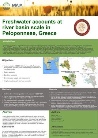
Case study area: Alfeios river basin
Greece
Annual irrigation water use (in m3) in 2018
Annual drinking water supply(in m3) in 2021
Summer drinking water supply (in m3) in
2021
Peloponnese
2. Assessing the accuracy
of remote sensing of
land cover change
detection for urban
ecosystem accounting
Introduction
Time-series of satellite imagery have a large potential for the
continuous monitoring of urban land cover changes. Slow and
fragmented land cover change in urban ecosystems pose a
challenge for urban ecosystem extent and condition accounting.
Little research has been done on the accuracy of high-resolution
open source data such as Copernicus Sentinel-2 for this
purpose. Assessment of uncertainty and confidence in trend
detection is rare in ecosystem accounting applications
Objectives
• Quantify the accuracy of change detection depending on the
type of land cover change
• Assess recommended size of a basic spatial unit and length
of accounting period as a function of type of landcover
change and the change detection accuracy of the remote
sensor
Methods
Results
• Change patches of 50 m2 (i.e. half of the size of the Sentinel-2 pixel) allowed detection of
changes smaller than the pixel size and maximized the number of classes with producer’s
accuracy > 50%.
• Different accuracy levels are associated with different land cover change types due to different
frequencies of occurrence in the area, average size of the patches, and different spectral signal.
• A four year accounting period was sufficient to detect significant trends in almost all land cover
changes
Implications for ecosystem accounting
• Direct land cover change classification allows for greater trend detection accuracy than
classifying opening and closing landcover extents
• Detection of trends in ecosystem extent and condition can have higher spatial resolution
than ecosystem service and asset accounting based on opening extents.
Authors
Megan Sarah Nowell *,
Stefano Puliti ¤, Zander
Venter*, and David N. Barton*
Affiliations
*Norwegian Institute of Nature
Research(NINA); ¤Norwegian
Institute for Bioeconomy
Research (NIBIO)
1. manual delineation of land cover change polygons 2015-
2019 for a sample of 93 square plots in Oslo, Norway.
2. train random forest classifiers iteratively by reducing the
sample size based on a minimum area threshold (5 – 100
m2)
3. calculate the overall and class-specific producer’s accuracy.
4. produce a wall-to-wall map of land cover type change for the
entire municipality using the classifier trained using all
change patch sizes > 50 m2
Source: Nowell et al. (forthcoming) Direct change mapping of urban land cover: how remote sensing can inform ecosystem accounting
GROUND TRUTHING
CHANGE MAPPING CHANGE DETECTION ACCURACY LANDCOVER CHANGE ACCOUNT