INFRARISK. Novel Indicators for identifying critical INFRAstructure at RISK from natural hazards
•
0 likes•146 views

Europe is the third most affected region by natural disasters costing €10 billion annually on average. The INFRARISK project aims to develop reliable stress tests to establish the resilience of critical European infrastructures to rare extreme natural hazard events and support long-term decision making regarding robust infrastructure development and protection. The project will create harmonized risk assessment methods and a decision support tool to help infrastructure managers minimize impacts through mitigation and response strategies.
Recommended

Recommended
More Related Content
What's hot
What's hot (20)
Similar to INFRARISK. Novel Indicators for identifying critical INFRAstructure at RISK from natural hazards
Similar to INFRARISK. Novel Indicators for identifying critical INFRAstructure at RISK from natural hazards (20)
More from Infra Risk
More from Infra Risk (7)
Recently uploaded
Recently uploaded (20)
INFRARISK. Novel Indicators for identifying critical INFRAstructure at RISK from natural hazards
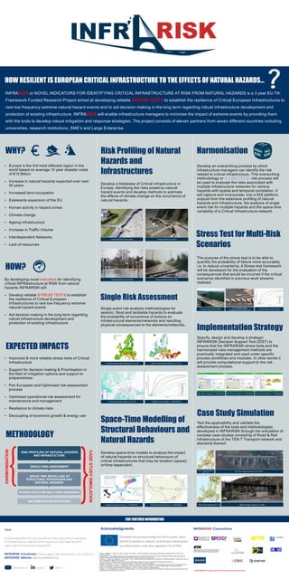
- 1. Europe is the 3rd most effected region in the world based on average 10 year disaster costs of €10 Billion Increase in natural hazards expected over next 50 years Increased land occupation Eastwards expansion of the EU Human activity in hazard zones Climate change Ageing infrastructure Increase in Traffic Volume Interdependent Networks Lack of resources By developing novel for identifyingindicators critical INFRAstructure at RISK from natural hazards INFRARISK will: Develop reliable to establishSTRESS TESTS the resilience of Critical European Infrastructures to rare low frequency extreme natural hazard events Aid decision making in the long term regarding robust infrastructure development and protection of existing infrastructure Improved & more reliable stress tests of Critical Infrastructure Support for decision making & Prioritisation in the field of mitigation options and support to preparedness Pan European and Optimised risk assessment process Optimised operational risk assessment for maintenance and management Resilience to climate risks Decoupling of economic growth & energy use HARMONISATION CASESTUDYSIMULATION RISK PROFILING OF NATURAL HAZARDS AND INFRASTUCTURE SINGLE RISK ASSESSMENT SPACE-TIME MODELLING OF STRUCTURAL BEHAVIOURS AND NATURAL HAZARDS STRESS TESTS FOR MULTI-RISK SCENARIOS IMPLEMENTATION STRATEGEY Alfieri, L., Salamon, P., Bianchi, A., Neal, J., Bates, P. and Feyen, L. (2013). Advances in pan-European flood hazard mapping, Hydrol. Process., doi: 10.1002/hyp.9947 Casas, Joan R. , Piotr Olaszek, Aljońa Ńajna, Aleń Ņnidarič, Igor Lavrič, Recommendations on the use of soft, diagnostic and proof load testing, Report ARCHES Assessment and Rehabilitation of Central European Highway Structures, August 2009 Di Sarno, L., Giannini, R., Paolacci, F., and Taucer, F. (2011). Seismic analysis and retrofitting of an existing R.C. highway bridge part I: Assessment of the "as- built" configuration', ANIDIS 2011, Bari, Italy. Erdik, M. 'Report on 1999 Kocaeli and Düzce (Turkey) Earthquakes', Bogazici University - Department of Earthquake Engineering European Commission, (2013). The Core Network Corridors, Trans European Transport Network Giardini, D., Woessner, J., Danciu, L., Crowley, H., Cotton, F., Grünthal, G., Pinho R., Valensise G. and the SHARE consortium. (2013). SHARE European Seismic Hazard Map for Peak Ground Acceleration, 10% Exceedance Probabilities in 50 years, doi: 10.2777/30345, ISBN-13, 978-92-79-25148-1 Lažeta, T. et al. (2008). Projekt željezničke pruge:Botovo – Zagreb – Rijeka. In: Sabor hrvatskih graditelja Panagos, P., Van Liedekerke, M., Jones, A. and Montanarella, L., (2012). European Soil Data Centre: Response to European policy support and public data requirements, Land Use Policy, 29, 329-338. INFRA or NOVEL INDICATORS FOR IDENTIFYING CRITICAL INFRASTRUCTURE AT RISK FROM NATURAL HAZARDS is a 3 year EU 7thRISK Framework Funded Research Project aimed at developing reliable to establish the resilience of Critical European Infrastructures toSTRESS TESTS rare low frequency extreme natural hazard events and to aid decision making in the long term regarding robust infrastructure development and protection of existing infrastructure. INFRA will enable infrastructure managers to minimise the impact of extreme events by providing themRISK with the tools to develop robust mitigation and response strategies. The project consists of eleven partners from seven different countries including universities, research institutions, SME's and Large Enterprise. Image provided by Van Gelder Image provided by Tucker Image provided by Van Gelder Image courtesy of Erdik (1999) Single event risk analysis methodologies for seismic, flood and landslide hazards to evaluate the probability of occurrence of actions on infrastructural elements/networks and resulting physical consequences to the elements/networks. Develop a Database of Critical Infrastructure in Europe, identifying the risks posed by natural hazard events and develop methods to estimate the effects of climate change on the occurrence of natural hazards. Landslide Hazard Map (Panagos et al. 2012) Seismic Hazard Map (Giardini et al. 2013) Flood Hazard Map (Alfieri et al. 2013) Fragility Curves (Cheng, T., INFRARISK) Develop space-time models to analyse the impact of natural hazards on structural behaviours of critical infrastructures that may be location (space) or/time dependent. Risk Profiling of Natural Hazards and Infrastructures Space-Time Modelling of Structural Behaviours and Natural Hazards Database Properties (Cheng, T., INFRARISK) Network Modelling (Cheng, T., INFRARISK) Stress Test for Multi-Risk Scenarios Develop an overarching process by which infrastructure managers can identify the risk related to critical infrastructure. THe overarching methodology or risk process willHARMONISED be used to evaluate the risks associated with multiple infrastructure networks for various hazards with spatial and temporal correlation. It will capture and incorporate, into a GIS platform, outputs from the extensive profiling of natural hazards and infrastructure, the analysis of single event risk for multiple hazards and the space time variability of a Critical Infrastructure network. The purpose of the stress test is to be able to quantify the probability of failure more accurately i.e. to reduce uncertainty. A Stress test framework will be developed for the evaluation of the consequences that would be incurred if the critical scenarios identified in previous work streams realised. Physical Test (Arches 2009) Actual Observations (Image provided by Gavin, K) Physical Test (Arches 2009) Specify, design and develop a strategic INFRARISK Decision Support Tool (IDST) to ensure that the INFRARISK stress tests and the harmonized risks management methods are practically integrated and used under specific process workflows and modules. In other words it will provide computational support to the risk assessment process. IDST Mock-up (Sabeur, Z., INFRARISK) IDST Mock-up (Sabeur, Z., INFRARISK) IDST Mock-up (Sabeur, Z., INFRARISK) Test the applicability and validate the effectiveness of the tools and methodologies developed in INFRARISK through the simulation of complex case studies consisting of Road & Rail Infrastructure of the TEN-T Transport network and elements thereof. TEN-T Road Network (EC '13) Rio Torto Viaduct (Di Sarno et al. 2011) Rječina Bridge (Lažeta et al. 2008)TEN-T Road Network (EC '13)