1. .
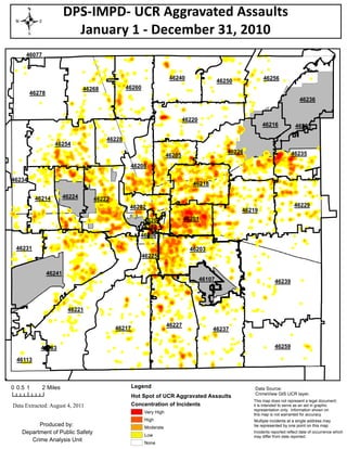
DPS-IMPD- UCR Aggravated Assaults
January 1 - December 31, 2010
46077
46240 46256
46250
46268 46260
46278
46236
46220
46216 46235
46228
46254
46226 46235
46205
46208
46234
46218
46214 46224 46222
46202 46229
46219
46204 46201
46282
46206
46231 46203
46225
46241
46107 46239
46221
46227
46217 46237
46183 46259
46113
0 0.5 1 2 Miles Legend Data Source:
CrimeView GIS UCR layer.
Hot Spot of UCR Aggravated Assaults
This map does not represent a legal document;
Data Extracted: August 4, 2011 Concentration of Incidents it is intended to serve as an aid in graphic
representation only. Information shown on
Very High this map is not warranted for accuracy.
High Multiple incidents at a single address may
Produced by: Moderate be represented by one point on this map.
Department of Public Safety Low
Incidents reported reflect date of occurrence which
may differ from date reported.
Crime Analysis Unit None