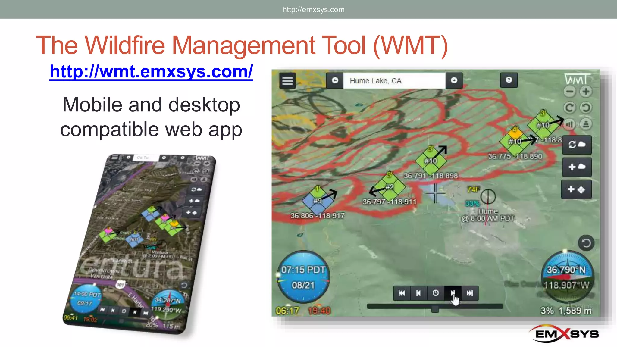
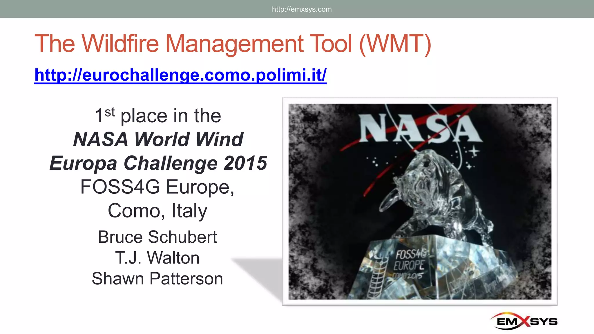
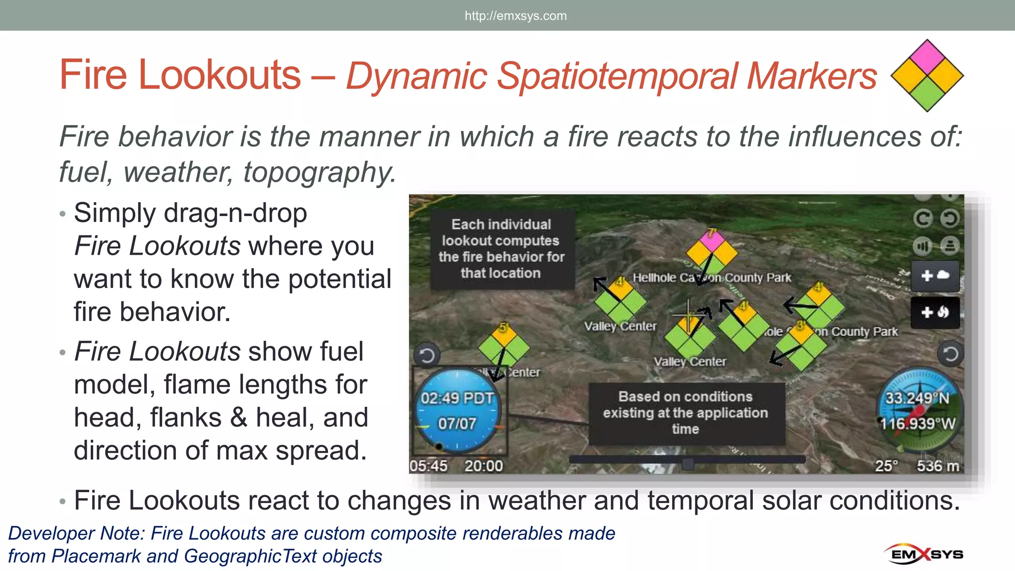
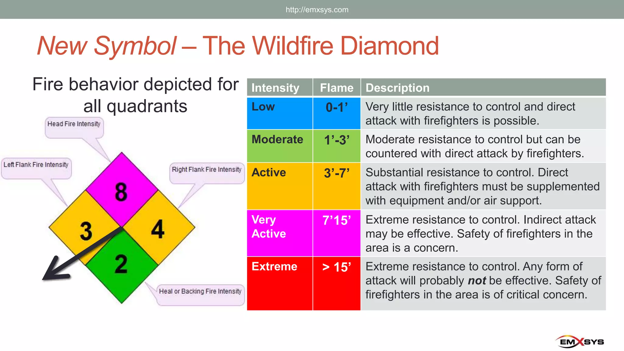
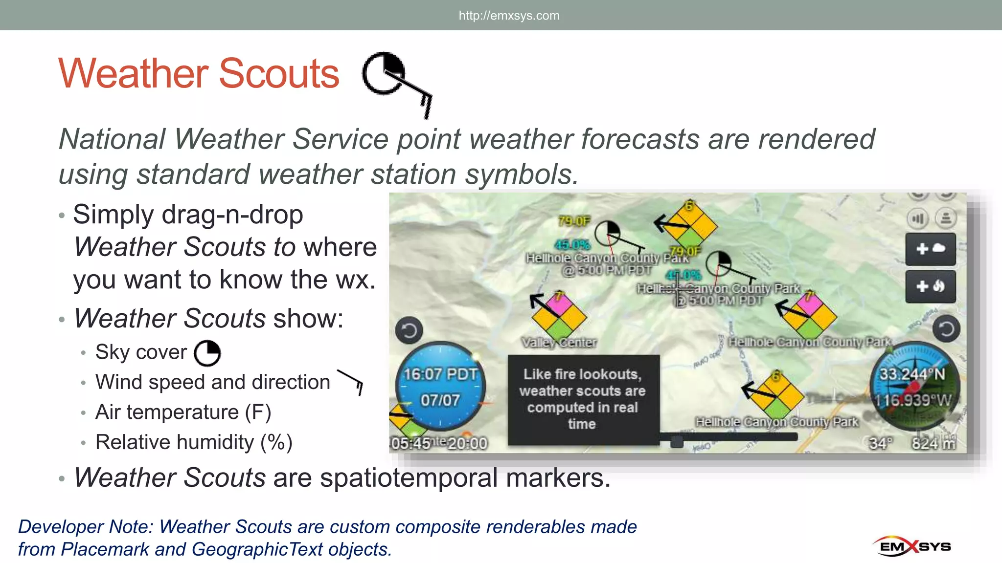
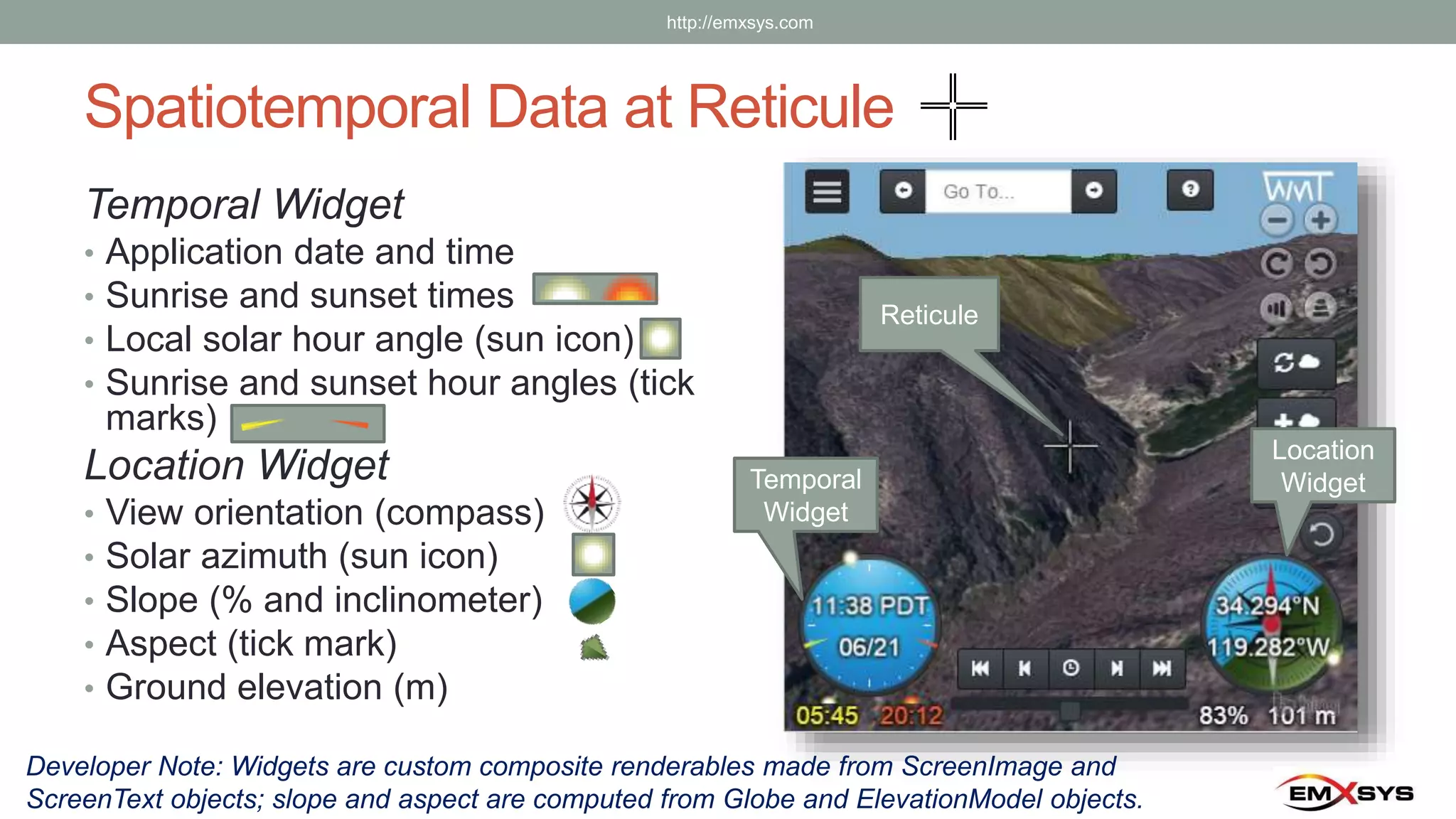
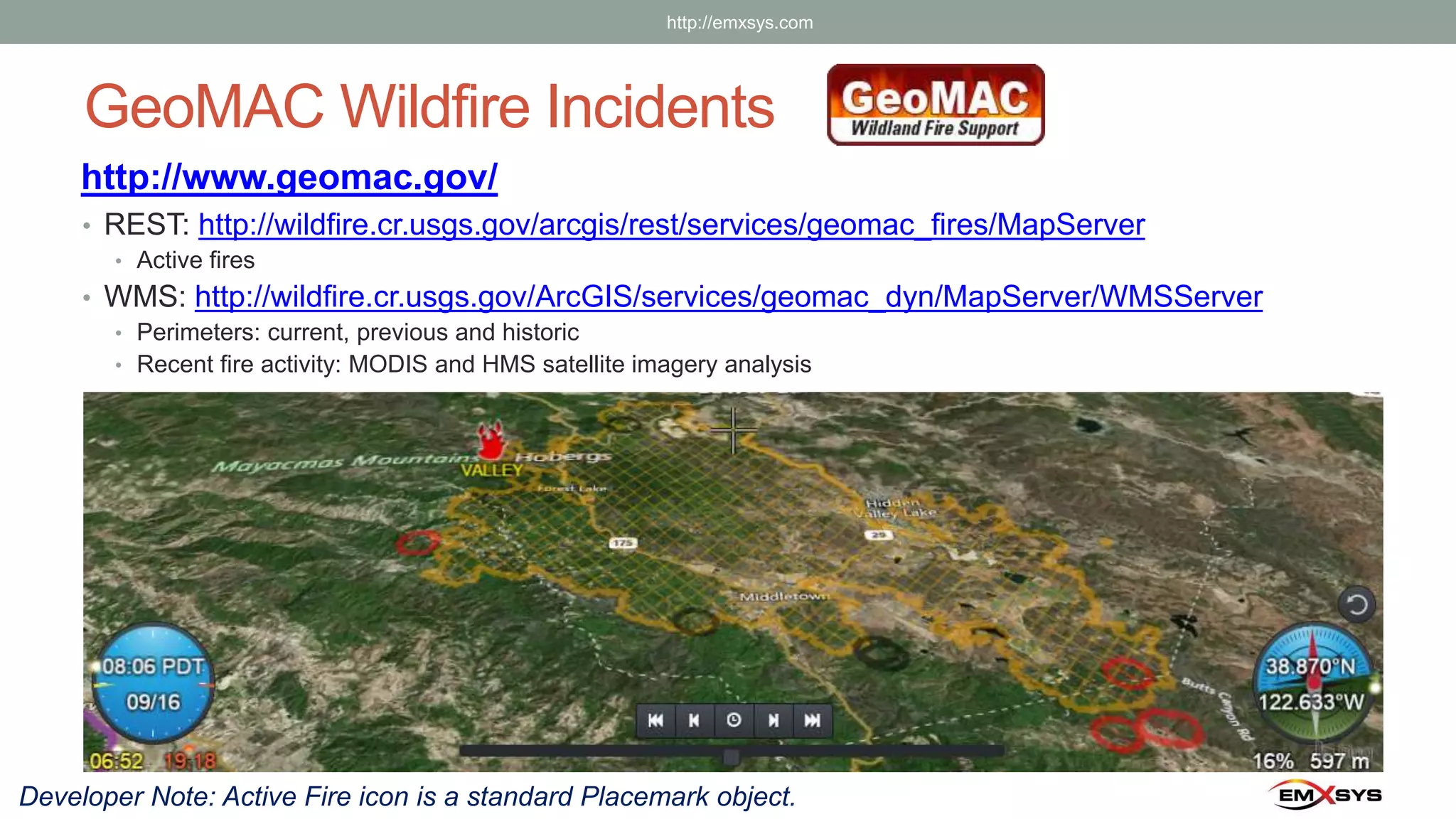
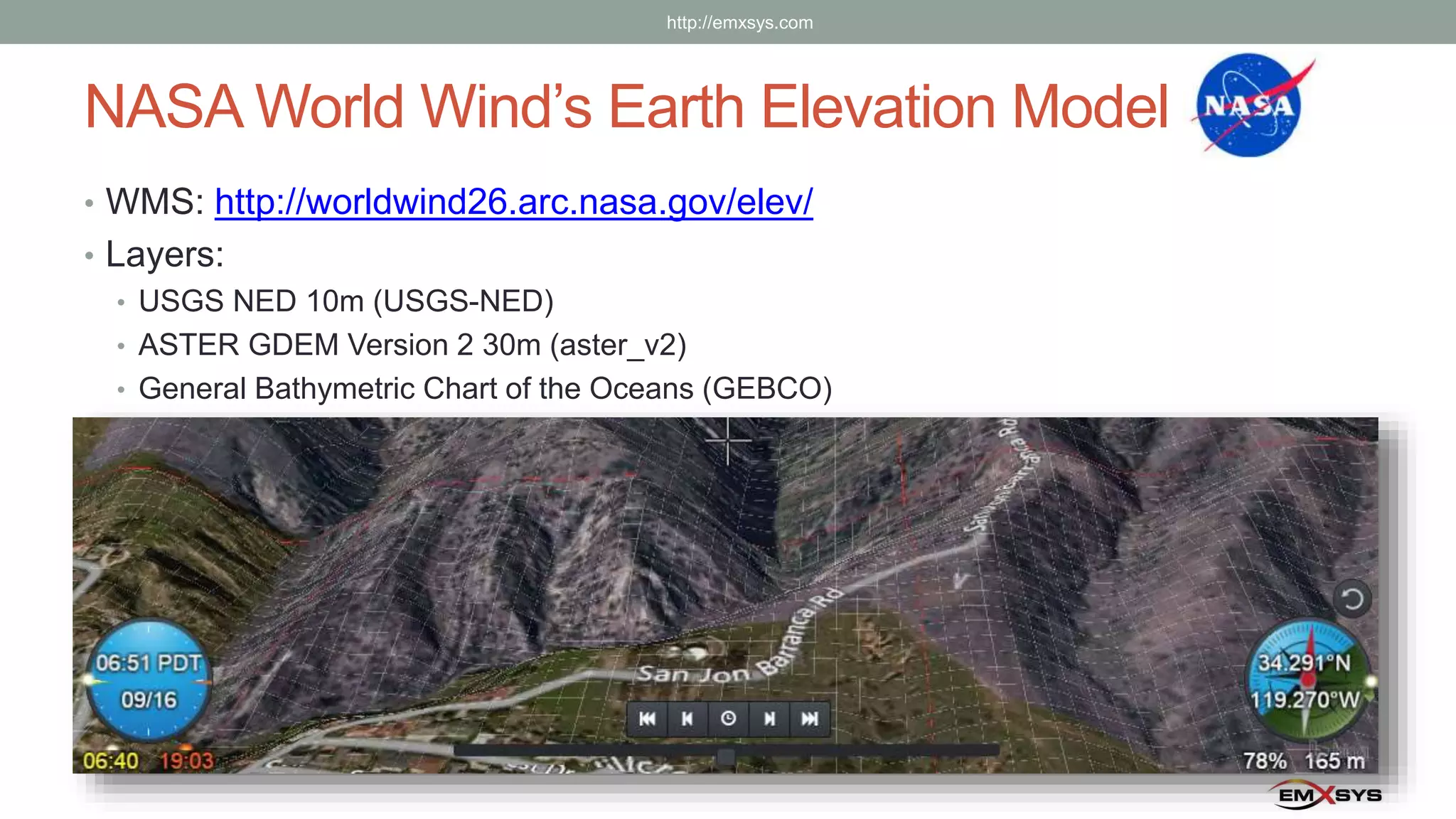
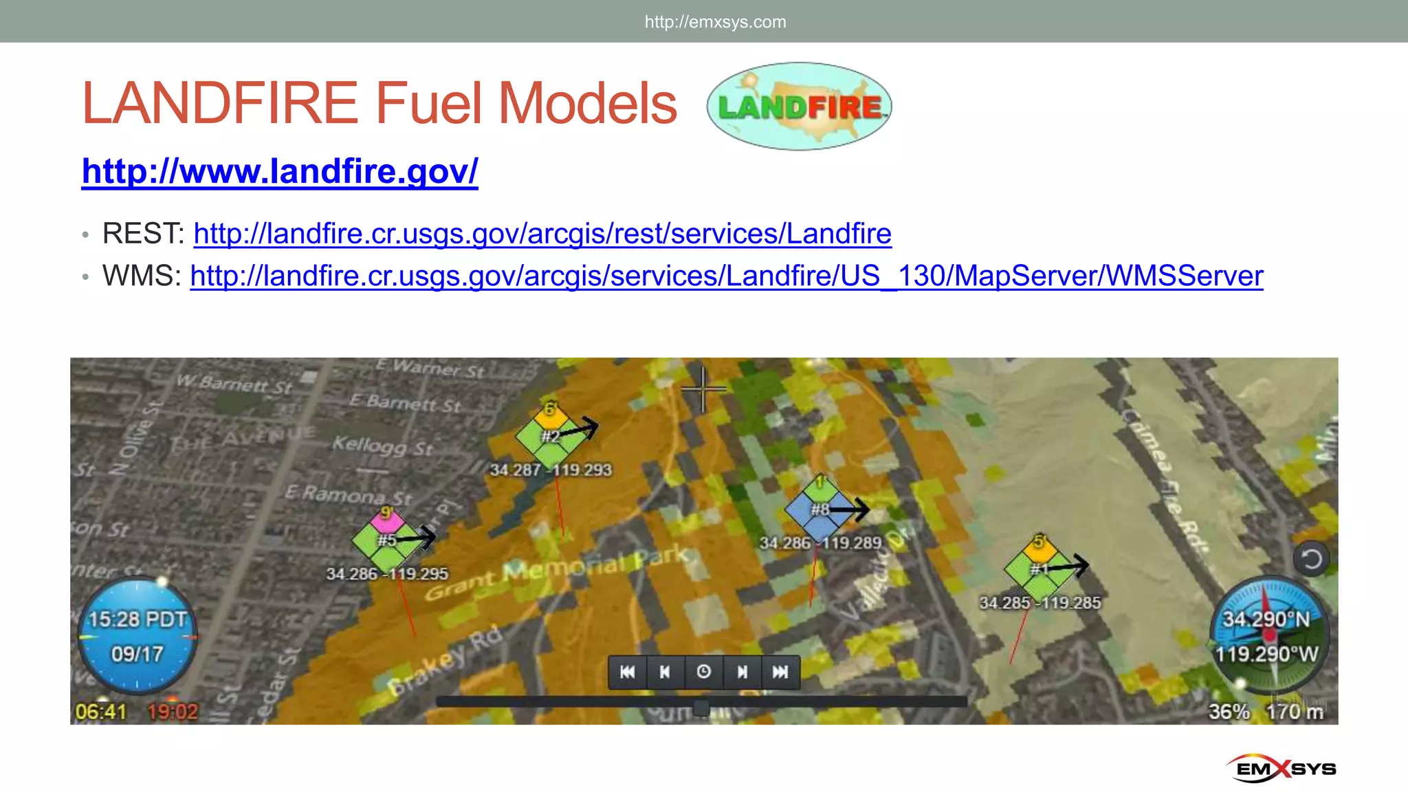
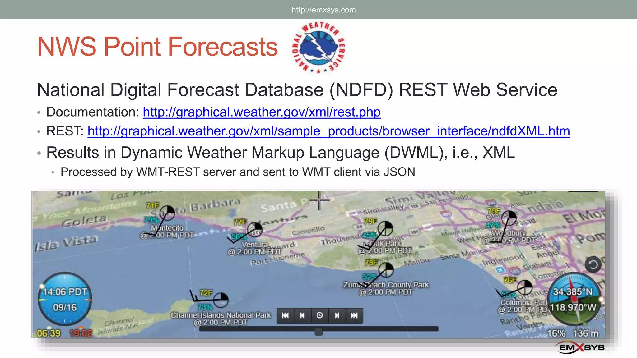
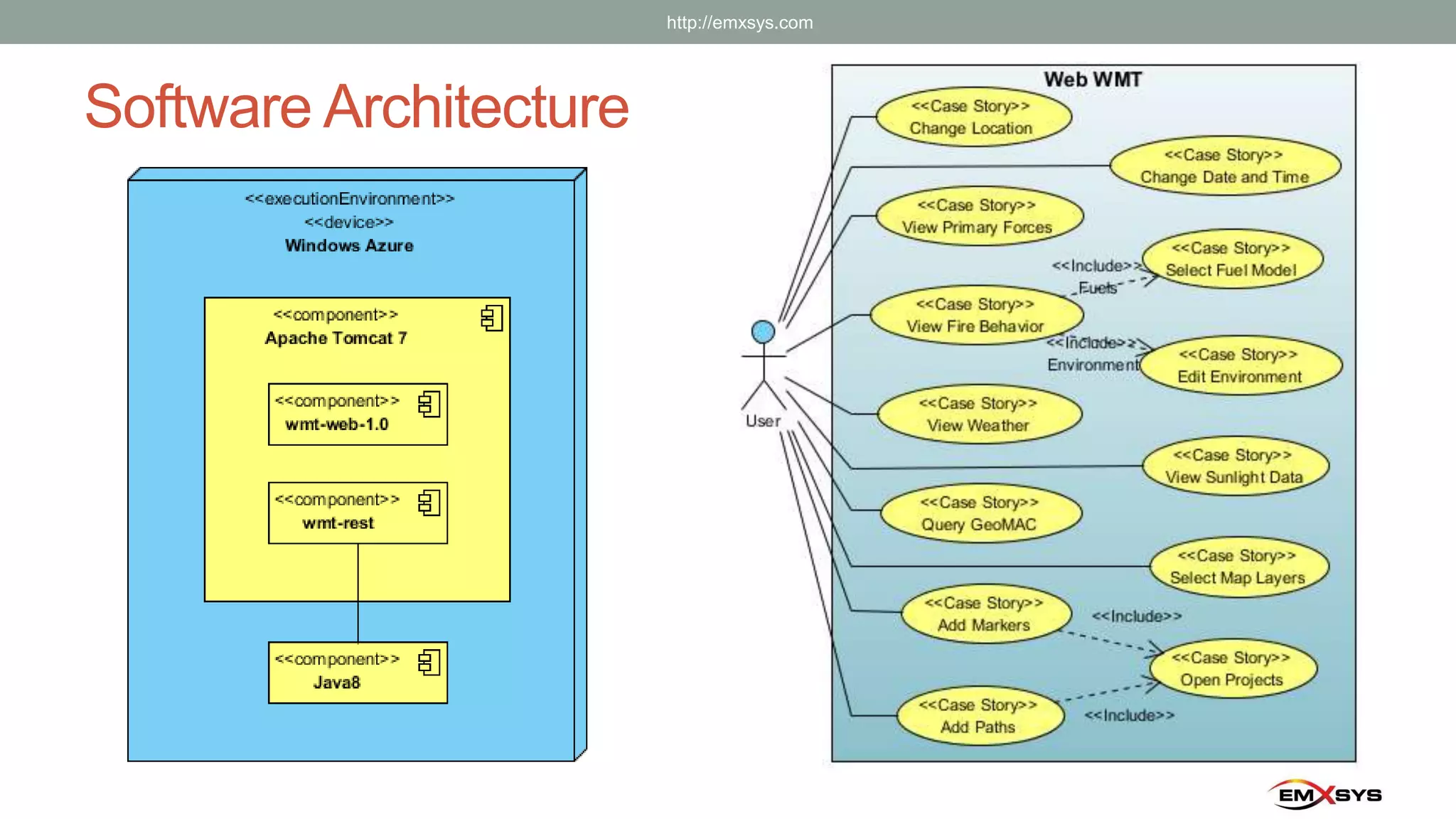
WILDFIRE
MANAGEMENT TOOL
WEB EDITION
Using NASA Web World Wind to Predict Wildfire Behavior
Southern California Government GIS User Group
Torrance, CA
September 16, 2015
http://emxsys.com
The Wildfire Management Tool (WMT)
http://wmt.emxsys.com/
Mobile and desktop
compatible web app
http://emxsys.com
The Wildfire Management Tool (WMT)
1st place in the
NASA World Wind
Europa Challenge 2015
FOSS4G Europe,
Como, Italy
Bruce Schubert
T.J. Walton
Shawn Patterson
http://eurochallenge.como.polimi.it/
http://emxsys.com
Built on NASA’s Web Word Wind SDK
http://webworldwind.org/
• JavaScript API
• Well crafted; extensible, easy to use
• Custom shapes
• Analytic surfaces, rigid shapes, terrain
conforming surface shapes, volumes,
place marks, geographic text, ….
• 3D globe and continuous 2D map
mode with extensible projections
• KML and Collada support
• Flexible and extensible viewing and
navigation system
• Shapefile support
• WCS and WMS support
3D Globe
Visualization
Imagery
Terrain
http://emxsys.com
Embodies the Campbell Prediction System (CPS)
• Alignment of Forces Concept
• In-alignment tracks
• Trigger Points
• Geographic/Temporal
• Fuel Flammability Curves
• Replications
http://emxsys.com
Learn from the Past—Predict the Future
What does the fire tell you?
Includes Rothermel’s Fire Spread Model
http://emxsys.com
Richard C. Rothermel
Fire Lookouts – Dynamic Spatiotemporal Markers
Fire behavior is the manner in which a fire reacts to the influences of:
fuel, weather, topography.
• Simply drag-n-drop
Fire Lookouts where you
want to know the potential
fire behavior.
• Fire Lookouts show fuel
model, flame lengths for
head, flanks & heal, and
direction of max spread.
• Fire Lookouts react to changes in weather and temporal solar conditions.
Developer Note: Fire Lookouts are custom composite renderables made
from Placemark and GeographicText objects
http://emxsys.com
New Symbol – The Wildfire Diamond
Fire behavior depicted for
all quadrants
Intensity Flame Description
Low 0-1’ Very little resistance to control and direct
attack with firefighters is possible.
Moderate 1’-3’ Moderate resistance to control but can be
countered with direct attack by firefighters.
Active 3’-7’ Substantial resistance to control. Direct
attack with firefighters must be supplemented
with equipment and/or air support.
Very
Active
7’15’ Extreme resistance to control. Indirect attack
may be effective. Safety of firefighters in the
area is a concern.
Extreme > 15’ Extreme resistance to control. Any form of
attack will probably not be effective. Safety of
firefighters in the area is of critical concern.
http://emxsys.com
Weather Scouts
National Weather Service point weather forecasts are rendered
using standard weather station symbols.
• Simply drag-n-drop
Weather Scouts to where
you want to know the wx.
• Weather Scouts show:
• Sky cover
• Wind speed and direction
• Air temperature (F)
• Relative humidity (%)
• Weather Scouts are spatiotemporal markers.
Developer Note: Weather Scouts are custom composite renderables made
from Placemark and GeographicText objects.
http://emxsys.com
Spatiotemporal Data at Reticule
Temporal Widget
• Application date and time
• Sunrise and sunset times
• Local solar hour angle (sun icon)
• Sunrise and sunset hour angles (tick
marks)
Location Widget
• View orientation (compass)
• Solar azimuth (sun icon)
• Slope (% and inclinometer)
• Aspect (tick mark)
• Ground elevation (m)
Developer Note: Widgets are custom composite renderables made from ScreenImage and
ScreenText objects; slope and aspect are computed from Globe and ElevationModel objects.
Temporal
Widget
Location
Widget
Reticule
http://emxsys.com
GeoMAC Wildfire Incidents
http://www.geomac.gov/
• REST: http://wildfire.cr.usgs.gov/arcgis/rest/services/geomac_fires/MapServer
• Active fires
• WMS: http://wildfire.cr.usgs.gov/ArcGIS/services/geomac_dyn/MapServer/WMSServer
• Perimeters: current, previous and historic
• Recent fire activity: MODIS and HMS satellite imagery analysis
Developer Note: Active Fire icon is a standard Placemark object.
http://emxsys.com
NASA World Wind’s Earth Elevation Model
• WMS: http://worldwind26.arc.nasa.gov/elev/
• Layers:
• USGS NED 10m (USGS-NED)
• ASTER GDEM Version 2 30m (aster_v2)
• General Bathymetric Chart of the Oceans (GEBCO)
http://emxsys.com
LANDFIRE Fuel Models
• REST: http://landfire.cr.usgs.gov/arcgis/rest/services/Landfire
• WMS: http://landfire.cr.usgs.gov/arcgis/services/Landfire/US_130/MapServer/WMSServer
http://www.landfire.gov/
http://emxsys.com
NWS Point Forecasts
National Digital Forecast Database (NDFD) REST Web Service
• Documentation: http://graphical.weather.gov/xml/rest.php
• REST: http://graphical.weather.gov/xml/sample_products/browser_interface/ndfdXML.htm
• Results in Dynamic Weather Markup Language (DWML), i.e., XML
• Processed by WMT-REST server and sent to WMT client via JSON
http://emxsys.com
Wind Affects Fire
• Flames are inclined towards
the fuel
• Fuels are heated by
radiation and convection
• Direction of max spread is
inline with wind direction
http://emxsys.com
Slope Affects Fire
• Upslope fuels are closer to
the flames.
• The results are very similar
to the effect of wind.
• In the absence of wind,
direction of max spread
follows upslope vector
http://emxsys.com
Solar Radiation Affects Fire
• Changes the fuel flammability
• Solar Radiation preheats the fuel
• Drives off moisture, making the fuel
more flammable
• Changes with time and aspect
• Creates an unstable fuel bed
http://emxsys.com
CPS Alignment of Forces Concept
• Variations in Wind, Slope and Preheating explain changes in fire
behavior
• Wind, Slope and Preheat are the primary forces
• Fire Behavior is affected by variations in:
• Strength
• Dominance
• Alignment
• In-Alignment Forces Exacerbate Fire Behavior
• Out-of-Alignment Forces Reduce Fire Behavior
http://emxsys.com
Software Architecture
http://emxsys.com
In Closing
• Email:
• “Bruce Schubert” bruce@emxsys.com
• Website:
• http://emxsys.com
• WMT Web App:
• http://wmt.emxsys.com
• Wildfire Management Tool – Web open source project
(wiki, issue tracker, and source code):
• https://bitbucket.org/emxsys/wildfire-management-tool-web/
http://emxsys.com

Wildfire Management Tool - Using NASA Web World Wind to Predict Wildfire Behavior

  • 1.
    WILDFIRE MANAGEMENT TOOL WEB EDITION UsingNASA Web World Wind to Predict Wildfire Behavior Southern California Government GIS User Group Torrance, CA September 16, 2015 http://emxsys.com
  • 2.
    The Wildfire ManagementTool (WMT) http://wmt.emxsys.com/ Mobile and desktop compatible web app http://emxsys.com
  • 3.
    The Wildfire ManagementTool (WMT) 1st place in the NASA World Wind Europa Challenge 2015 FOSS4G Europe, Como, Italy Bruce Schubert T.J. Walton Shawn Patterson http://eurochallenge.como.polimi.it/ http://emxsys.com
  • 4.
    Built on NASA’sWeb Word Wind SDK http://webworldwind.org/ • JavaScript API • Well crafted; extensible, easy to use • Custom shapes • Analytic surfaces, rigid shapes, terrain conforming surface shapes, volumes, place marks, geographic text, …. • 3D globe and continuous 2D map mode with extensible projections • KML and Collada support • Flexible and extensible viewing and navigation system • Shapefile support • WCS and WMS support 3D Globe Visualization Imagery Terrain http://emxsys.com
  • 5.
    Embodies the CampbellPrediction System (CPS) • Alignment of Forces Concept • In-alignment tracks • Trigger Points • Geographic/Temporal • Fuel Flammability Curves • Replications http://emxsys.com Learn from the Past—Predict the Future What does the fire tell you?
  • 6.
    Includes Rothermel’s FireSpread Model http://emxsys.com Richard C. Rothermel
  • 7.
    Fire Lookouts –Dynamic Spatiotemporal Markers Fire behavior is the manner in which a fire reacts to the influences of: fuel, weather, topography. • Simply drag-n-drop Fire Lookouts where you want to know the potential fire behavior. • Fire Lookouts show fuel model, flame lengths for head, flanks & heal, and direction of max spread. • Fire Lookouts react to changes in weather and temporal solar conditions. Developer Note: Fire Lookouts are custom composite renderables made from Placemark and GeographicText objects http://emxsys.com
  • 8.
    New Symbol –The Wildfire Diamond Fire behavior depicted for all quadrants Intensity Flame Description Low 0-1’ Very little resistance to control and direct attack with firefighters is possible. Moderate 1’-3’ Moderate resistance to control but can be countered with direct attack by firefighters. Active 3’-7’ Substantial resistance to control. Direct attack with firefighters must be supplemented with equipment and/or air support. Very Active 7’15’ Extreme resistance to control. Indirect attack may be effective. Safety of firefighters in the area is a concern. Extreme > 15’ Extreme resistance to control. Any form of attack will probably not be effective. Safety of firefighters in the area is of critical concern. http://emxsys.com
  • 9.
    Weather Scouts National WeatherService point weather forecasts are rendered using standard weather station symbols. • Simply drag-n-drop Weather Scouts to where you want to know the wx. • Weather Scouts show: • Sky cover • Wind speed and direction • Air temperature (F) • Relative humidity (%) • Weather Scouts are spatiotemporal markers. Developer Note: Weather Scouts are custom composite renderables made from Placemark and GeographicText objects. http://emxsys.com
  • 10.
    Spatiotemporal Data atReticule Temporal Widget • Application date and time • Sunrise and sunset times • Local solar hour angle (sun icon) • Sunrise and sunset hour angles (tick marks) Location Widget • View orientation (compass) • Solar azimuth (sun icon) • Slope (% and inclinometer) • Aspect (tick mark) • Ground elevation (m) Developer Note: Widgets are custom composite renderables made from ScreenImage and ScreenText objects; slope and aspect are computed from Globe and ElevationModel objects. Temporal Widget Location Widget Reticule http://emxsys.com
  • 11.
    GeoMAC Wildfire Incidents http://www.geomac.gov/ •REST: http://wildfire.cr.usgs.gov/arcgis/rest/services/geomac_fires/MapServer • Active fires • WMS: http://wildfire.cr.usgs.gov/ArcGIS/services/geomac_dyn/MapServer/WMSServer • Perimeters: current, previous and historic • Recent fire activity: MODIS and HMS satellite imagery analysis Developer Note: Active Fire icon is a standard Placemark object. http://emxsys.com
  • 12.
    NASA World Wind’sEarth Elevation Model • WMS: http://worldwind26.arc.nasa.gov/elev/ • Layers: • USGS NED 10m (USGS-NED) • ASTER GDEM Version 2 30m (aster_v2) • General Bathymetric Chart of the Oceans (GEBCO) http://emxsys.com
  • 13.
    LANDFIRE Fuel Models •REST: http://landfire.cr.usgs.gov/arcgis/rest/services/Landfire • WMS: http://landfire.cr.usgs.gov/arcgis/services/Landfire/US_130/MapServer/WMSServer http://www.landfire.gov/ http://emxsys.com
  • 14.
    NWS Point Forecasts NationalDigital Forecast Database (NDFD) REST Web Service • Documentation: http://graphical.weather.gov/xml/rest.php • REST: http://graphical.weather.gov/xml/sample_products/browser_interface/ndfdXML.htm • Results in Dynamic Weather Markup Language (DWML), i.e., XML • Processed by WMT-REST server and sent to WMT client via JSON http://emxsys.com
  • 15.
    Wind Affects Fire •Flames are inclined towards the fuel • Fuels are heated by radiation and convection • Direction of max spread is inline with wind direction http://emxsys.com
  • 16.
    Slope Affects Fire •Upslope fuels are closer to the flames. • The results are very similar to the effect of wind. • In the absence of wind, direction of max spread follows upslope vector http://emxsys.com
  • 17.
    Solar Radiation AffectsFire • Changes the fuel flammability • Solar Radiation preheats the fuel • Drives off moisture, making the fuel more flammable • Changes with time and aspect • Creates an unstable fuel bed http://emxsys.com
  • 18.
    CPS Alignment ofForces Concept • Variations in Wind, Slope and Preheating explain changes in fire behavior • Wind, Slope and Preheat are the primary forces • Fire Behavior is affected by variations in: • Strength • Dominance • Alignment • In-Alignment Forces Exacerbate Fire Behavior • Out-of-Alignment Forces Reduce Fire Behavior http://emxsys.com
  • 19.
  • 20.
    In Closing • Email: •“Bruce Schubert” bruce@emxsys.com • Website: • http://emxsys.com • WMT Web App: • http://wmt.emxsys.com • Wildfire Management Tool – Web open source project (wiki, issue tracker, and source code): • https://bitbucket.org/emxsys/wildfire-management-tool-web/ http://emxsys.com

Editor's Notes

  • #2 Target audience: GIS professionals Fire department personnel Developers Speaker: Bruce Schubert Emxsys Software Architect and Owner Open Source Developer Independent Contractor WMT WMTweb AeroComputers Software Architect and Developer Cartographer UltiChart Mission Management System Ventura County Fire Department Software Development Manager Incident Command System Situation Unit Leader Field Observer Volunteer Activities: Firefighter/Battalion Chief – Kitsap County Fire Protection District #7 Search, Rescue and First Aid – California State Parks CPR Instructor – American Heart Association Sound Technician (FOH and Recording) – Coastline Bible Church
  • #3 The WMT is … an open source web app that predicts the potential fire behavior of wildfires it is mobile and desktop compatible functional, but still under development technology preview Vision Statement For wildland firefighters and incident command personnel engaged in the suppression of wildland fires who need tactical decision support tools to ensure the safety of firefighters and the effective use of firefighting resources, the Wildfire Management Tool – Web Edition is a decision support system and visualization tool that displays the potential fire behavior on the fireground using the CPS methodologies. Unlike the WMT desktop software, this product runs in the web browser on smart phones, tablets, laptops and desktop computers.
  • #4 The WMT is … a 1st place winner in the NASA Word Wind Europa Challenge, Professional Track was presented/demonstrated at FOSS4G in Como Italy in July 2015 by T.J. Walton project is entirely self funded by Bruce Schubert has a liberal open source license: BSD 3-Clause License Development Team Bruce Schubert, Software Architect, Developer T.J. Walton, UI Designer Shawn Patterson, Graphics
  • #5 WMT is built on the NASA Web World Wind JavaScript Software Development Kit (SDK) based on NASA World Wind for Java SDK NASA does the heavy lifting Allows me to focus on problem domain: Wildfire NASA Web World Wind is … a 3D virtual globe with additional 2D projections an extensible JavaScript SDK, not an application used to build applications includes data visualization terrain surface images, analytic surfaces, 3D shapes place marks WMS Patrick Hogan, World Wind Program Manager Tom Gaskins, Software Architect
  • #6 Doug Campbell developed the Campbell Prediction System, a pragmatic approach to predicting fire behavior on the fireground. Retired Fire Behavior Analyst for the US Forest Service Fire Behavior Domain Expert Meteorologist in the Navy Doug was bothered by the burnover accidents and deaths of fellow firefighters, so he: Researched the “intuition” of successful firefighters Studied Countryman’s research papers on the fire environment Quantified his discoveries and insights in the Campbell Prediction System (CPS) The Campbell Prediction System is: A language for communicating fire behavior. A “boots on the ground” logic model for predicting when and where fire behavior will change. Additional info: Tenets of CPS include: Learn from the Past—Predict the Future Predict CHANGES! When and where fire behavior will change Fire behavior observations and replications Fuel Flammability Curves Trigger points Alignment of Forces Concept In alignment/out of alignment Effects of Solar Preheating Exacerbates fire behavior
  • #7 In 1972, aeronautical engineer Richard C. Rothermel, of the USDA Fire Sciences Lab at Missoula, Montana, developed a method for modeling the spread of wildfire. This equation is the backbone of many fire modeling systems, including BehavePlus and FARSITE and the now Wildfire Management Tool Additional Info: In the Rothermel equation, ROS is directly proportional to the propagation intensity and increases with increases in wind and slope (see the numerator). ROS is inversely proportional to the amount of energy required to ignite fuels (the denominator). One of the key points about Rothermel’s fire spread equation is that the rate of spread is a ratio between energy absorbed prior to ignition and the energy produced by burning. So, fire rate of spread is strongly influenced by the intrinsic fuel properties and by the fire environment. In this model, fire spread is considered to be from one point to the next. A fire will spread if there is sufficient heat to preheat and ignite the next piece of fuel. This equation predicts the ROS at the head of the fire only. The numerator in this equation deals with the exothermic portion of the reaction (the heat source), while the denominator deals with the endothermic portion of the reaction (the heat sink). Input Variables: IR is the reaction intensity ξ is the propagating flux ratio Φw is the wind coefficient Φs is the slope factor Ρb is the oven-dry fuel bed bulk density ε is the effective heating number Qig is the heat of preignition Source: FOR 434 Fire Behavior Basics Chad Hoffman University of Idaho
  • #8 To be safe, firefighters must be able to predict the fire behavior in the areas that they are deployed. “Fire behavior is defined as the manner in which fuel ignites, flame develops, fire spreads and exhibits other related phenomena as determined by the interaction of fuels, weather, and topography (i.e., the fire environment).” (Alexander 2006) Fuels: Fuels are the light fuels (dead ¼” fuels) that carry the flaming front of the fire. The light fuels can react to a changing environment within 1 hour. Weather: In the weather, wind is the dominate force Wind preheats the fuels in front of it through radiation and convection. Topography: In the topography, the steepness of slope affects fire behavior in a manner similar to wind preheating the upslope fuels In the absence of wind, slope can be a dominant force. The Wildfire Management Tool software provides you with an understanding of these relationships via Fire Lookouts. Fire Lookouts are spatiotemporal markers you drop on to the globe. A Fire Lookout downloads a point weather forecast for its location and computes the fire behavior from the weather, terrain, solar radiation and a fuel model. The Fire Lookout displays fire behavior data using the new Wildfire Diamond symbology. Fire Lookouts are dynamic. Advancing the application time with the time slider allows you to view the expected fire behavior in the future. When you move a Fire Lookout it triggers a new computation the fire behavior and it updates the symbology accordingly. Fire Lookouts are designed to alert the user when a significant change is detected in the future fire behavior. This lookout mechanism takes place behind the scenes alerts the user via visual cues.
  • #9 Wildfire perimeters have four parts: Head Left and right flanks Heal
  • #11 Note: Solar azimuth and aspect are coincident: the terrain at the crosshairs is receiving maximum solar radiation.
  • #13 WMT computes the aspect and slope using the WWW Globe and the EarthElevationModel objects. At the reticule (crosshairs) At each Fire Lookout location
  • #14 WMT uses usgs.landfire.gov for: REST services provide the fuel model for a specific location, e.g. for a Fire Lookout WMS used to display the FBFM13 (Original 13) fuel models.
  • #16 Flame inclines towards the fuel Also note that winds cool the fuel
  • #17 Show inclinometer Show wildfire diamond
  • #18 Show sun plot Show sky cover Show variation
  • #20 Architectural Views Deployment View wmt-web-1.0 is a JavaScript and HTML5 web application wmt-rest is a Java 8 REST server application Use Case View High-level use cases