General Forecast for SEPD Region
•
0 likes•205 views

Day 1 of 5 (0600 Friday 25th July to 0600 Saturday 26th July)

Recommended
Recommended
More Related Content
Viewers also liked
Viewers also liked (11)
Similar to General Forecast for SEPD Region
Similar to General Forecast for SEPD Region (12)
Recently uploaded
Recently uploaded (20)
General Forecast for SEPD Region
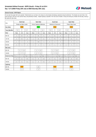
- 1. General Forecast - SEPD Region A very warm day again with sunny periods. Predominantly dry, but there is the chance of a few showers developing, especially during the afternoon. The showers are most likely in the south and east, and one or two could be heavy and potentially thundery - frequent lighting is possible in the most active showers. During the evening any showers will die away, leaving a dry night with clear skies. Mean Dir'n Gust Mean Dir'n Gust Mean Dir'n Gust Mean Dir'n Gust 10 NE 25 10 NE 25 10 NE 25 10 E 25 10 NE 25 15 NE 25 10 NE 25 10 NE 25 5 N 15 10 NW 15 10 N 15 5 N 15 10 N 15 15 N 15 10 N 10 10 N 10 Snow (cm) Line Icing Height (m) Snow (cm) Line Icing Height (m) Snow (cm) Line Icing Height (m) Snow (cm) Line Icing Height (m) 0.0 Nil N/A 0.0 Nil N/A 0.0 Nil N/A 0.0 Nil N/A 0.0 Nil N/A 0.0 Nil N/A 0.0 Nil N/A 0.0 Nil N/A Area North East North West South East South West Slough and West London Oxford, Reading & Melksham Aldershot & Portsmouth Poole & New Forest Risk (RAG) Amber Green Amber Amber Temp (Max/Min) 27 14 27 13 27 14 27 14 Wind 06h-12h 12h-18h 18h-00h 00h-06h Rain (mm) 06h-18h 0 - 5.0 0 - 3.0 0 - 6.0 0 - 5.0 18h-06h 0 - 1.0 0 - 1.0 0 - 2.0 0 - 2.0 Snow/Line Icing 06h-18h 18h-06h Lightning 06h-18h 2B 2C 2B 2B 18h-06h 3 3 3 3 Scheduled Utilities Forecast - SEPD (South) - Friday 25 Jul 2014 Day 1 of 5 (0600 Friday 25th July to 0600 Saturday 26th July)
- 2. General Forecast - SEPD Region A dry day is expected with long sunny periods. Very warm or hot once again. Clear skies overnight. Mean Dir'n Gust Mean Dir'n Gust Mean Dir'n Gust Mean Dir'n Gust 10 NW 20 10 N 20 10 W 15 10 NW 15 5 W 20 10 NW 20 10 W 20 10 W 20 10 NW 10 10 NW 15 10 NW 15 10 NW 15 10 NW 20 10 N 20 10 N 20 10 NW 20 Snow (cm) Line Icing Height (m) Snow (cm) Line Icing Height (m) Snow (cm) Line Icing Height (m) Snow (cm) Line Icing Height (m) 0.0 Nil N/A 0.0 Nil N/A 0.0 Nil N/A 0.0 Nil N/A 0.0 Nil N/A 0.0 Nil N/A 0.0 Nil N/A 0.0 Nil N/A Area North East North West South East South West Slough and West London Oxford, Reading & Melksham Aldershot & Portsmouth Poole & New Forest Risk (RAG) Green Green Green Green Temp (Max/Min) 28 14 28 14 28 14 28 14 Wind 06h-12h 12h-18h 18h-00h 00h-06h Rain (mm) 06h-18h 0 - 0 0 - 0 0 - 0 0 - 0 18h-06h 0 - 0 0 - 0 0 - 0 0 - 0 Snow/Line Icing 06h-18h 18h-06h Lightning 06h-18h 4 4 4 4 18h-06h 4 4 4 4 Day 2 of 5 (0600 Saturday 26th July to 0600 Sunday 27th July)
- 3. General Forecast - SEPD Region A less warm day with sunny spells and the chance of the odd shower in places. Isolated showers possible overnight too. General Forecast - SEPD Region Variable cloud with the chance of a few showers. Drier overnight. General Forecast - SEPD Region A dry and mostly fine day with sunny periods. Warm. Clear spells overnight. Mean Dir'n Gust Mean Dir'n Gust Mean Dir'n Gust 15 W 25 15 N 25 15 N 25 Snow (cm) Line Icing Height (m) Snow (cm) Line Icing Height (m) Snow (cm) Line Icing Height (m) 0.0 Nil N/A 0.0 Nil N/A 0.0 Nil N/A Day 3 of 5 (0600 Sunday 27th July to 0600 Monday 28th July) Day 4 of 5 (0600 Monday 28th July to 0600 Tuesday 29th July) Day 5 of 5 (0600 Tuesday 29th July to 0600 Wednesday 30th July) Area Day Three Day Four Day Five SEPD Region SEPD Region SEPD Region Risk (RAG) Green Green Green Temp (Max/Min) 25 12 23 13 25 12 Wind 24 hours Rain (mm) 24 hour total 24 hour total 24 hour total 24 hours 0 - 2 0 - 3 0 - 0 Snow/Line Icing 24 hours Lightning 24 hours 3 3 4 Days 6 to 10 (0600 Wednesday 30th July to 0600 Monday 4th August) Outlook A ridge of high pressure extending across England from the south-west should give largely dry and settled conditions through the period. It will often be warm.
- 4. Rainfall (mm) 12 hr (days 1 and 2) 24 hr (days 3 to 5) >50 >50 >=25 >25 <25 <=25 Snowfall (cm) 12 hr (days 1 and 2) 24 hr (days 3 to 5) if 24hr total >=10 >=3 >=5 >1 >=1 <=1 <1 if 24hr total >=5 >1 <=1 if 24hr total <5 any amount Overall risk of disruption Severe risk Red Significant risk Amber No risk Green The above reflects the worst case of any of the following Wind Gusts (mph) - 1st November - 31st March Direction N/NE/E All other directions >50 mph Red >70 mph Red >40 mph Amber >50 mph Amber <=40 mph Green <=50 mph Green Wind Gusts (mph) - 1st April - 31st October Direction N/NE/E All other directions >40 mph Red >60 mph Red >30 mph Amber >40 mph Amber <=30 mph Green <=40 mph Green
- 5. Line icing 12 hr (days 1 and 2) 24 hr (days 3 to 5) Severe Severe other 12hr > Nil Moderate Moderate other 12hr = Nil Moderate Slight Slight Nil Nil Lightning risk and disruption colour code matrix Risk level 1 A B C D Risk level 2 A B C D Risk level 3 A B C D Risk level 4 A B C D Lightning Risk Categories 1 - Lightning will almost certainly occur across the region, or is occurring 2 - Lightning is likely across the region 3 - Lightning is unlikely across the region, although convective activity or an active front is forecast 4 - Lightning is not expected to occur across the region Lightning Intensity Index A - Very frequent lightning strikes B - Frequent lightning strikes C - Infrequent lightning strikes D - Very infrequent lightning strikes All Temperatures in °C All Wind speeds in MPH