Scheduled Utilities Forecast - SEPD (South) - Monday 28 Jul 2014
•
0 likes•186 views

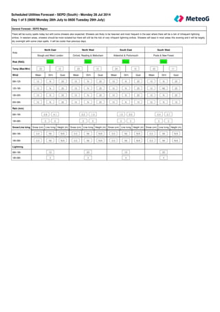
Day 1 of 5 (0600 Monday 28th July to 0600 Tuesday 29th July)

Recommended
Recommended
More Related Content
Viewers also liked
Viewers also liked (20)
Similar to Scheduled Utilities Forecast - SEPD (South) - Monday 28 Jul 2014
Similar to Scheduled Utilities Forecast - SEPD (South) - Monday 28 Jul 2014 (16)
Recently uploaded
Recently uploaded (20)
Scheduled Utilities Forecast - SEPD (South) - Monday 28 Jul 2014
- 1. General Forecast - SEPD Region There will be sunny spells today but with some showers also expected. Showers are likely to be heaviest and most frequent in the east where there will be a risk of infrequent lightning strikes. In western areas, showers should be more isolated but there will still be the risk of very infrquent lightning strikes. Showers will ease in most areas this evening and it will be largely dry overnight with some clear spells. It will be cooler than previous days. Mean Dir'n Gust Mean Dir'n Gust Mean Dir'n Gust Mean Dir'n Gust 10 N 20 10 N 20 10 N 20 10 N 20 10 N 20 15 N 25 10 N 25 10 NE 25 10 N 20 15 N 20 10 N 20 10 N 20 10 N 20 15 N 25 10 N 15 10 N 15 Snow (cm) Line Icing Height (m) Snow (cm) Line Icing Height (m) Snow (cm) Line Icing Height (m) Snow (cm) Line Icing Height (m) 0.0 Nil N/A 0.0 Nil N/A 0.0 Nil N/A 0.0 Nil N/A 0.0 Nil N/A 0.0 Nil N/A 0.0 Nil N/A 0.0 Nil N/A Area North East North West South East South West Slough and West London Oxford, Reading & Melksham Aldershot & Portsmouth Poole & New Forest Risk (RAG) Green Green Green Green Temp (Max/Min) 23 12 23 12 24 12 23 11 Wind 06h-12h 12h-18h 18h-00h 00h-06h Rain (mm) 06h-18h 0.8 - 4.1 0.2 - 1.3 1.0 - 9.0 0.4 - 2.7 18h-06h 0 - 0 0 - 0 0 - 0 0 - 0 Snow/Line Icing 06h-18h 18h-06h Lightning 06h-18h 1D 2D 1D 2D 18h-06h 3 3 4 4 Scheduled Utilities Forecast - SEPD (South) - Monday 28 Jul 2014 Day 1 of 5 (0600 Monday 28th July to 0600 Tuesday 29th July)
- 2. General Forecast - SEPD Region A dry day with some warm sunshine for most areas. It should remain dry overnight but it will become cloudier. Mean Dir'n Gust Mean Dir'n Gust Mean Dir'n Gust Mean Dir'n Gust 10 NW 20 10 NW 20 15 NW 20 10 NW 20 10 N 20 10 NW 20 15 NW 25 15 N 25 10 NW 15 15 N 15 10 N 20 10 N 20 10 N 15 15 N 20 10 N 15 10 NW 15 Snow (cm) Line Icing Height (m) Snow (cm) Line Icing Height (m) Snow (cm) Line Icing Height (m) Snow (cm) Line Icing Height (m) 0.0 Nil N/A 0.0 Nil N/A 0.0 Nil N/A 0.0 Nil N/A 0.0 Nil N/A 0.0 Nil N/A 0.0 Nil N/A 0.0 Nil N/A Area North East North West South East South West Slough and West London Oxford, Reading & Melksham Aldershot & Portsmouth Poole & New Forest Risk (RAG) Green Green Green Green Temp (Max/Min) 26 12 26 12 26 12 26 12 Wind 06h-12h 12h-18h 18h-00h 00h-06h Rain (mm) 06h-18h 0 - 0 0 - 0 0 - 0 0 - 0 18h-06h 0 - 0 0 - 0 0 - 0 0 - 0 Snow/Line Icing 06h-18h 18h-06h Lightning 06h-18h 4 4 4 4 18h-06h 4 4 4 4 Day 2 of 5 (0600 Tuesday 29th July to 0600 Wednesday 30th July)
- 3. General Forecast - SEPD Region Some places may be a cloudy start, but otherwise it will be another dry, warm day with plenty of sunshine. Dry overnight with clear skies. General Forecast - SEPD Region The generally settled, fine and dry weather will continue on Thursday. Dry overnight. General Forecast - SEPD Region Mainly dry on Friday although there will be the chance of a few sharp showers breaking out, these possibly giving very infrequent lightning strikes. The chance of showers may extend overnight. Mean Dir'n Gust Mean Dir'n Gust Mean Dir'n Gust 15 SW 25 20 SW 30 20 S 30 Snow (cm) Line Icing Height (m) Snow (cm) Line Icing Height (m) Snow (cm) Line Icing Height (m) 0.0 Nil N/A 0.0 Nil N/A 0.0 Nil N/A Day 3 of 5 (0600 Wednesday 30th July to 0600 Thursday 31st July) Day 4 of 5 (0600 Thursday 31st July to 0600 Friday 1st August) Day 5 of 5 (0600 Friday 1st August to 0600 Saturday 2nd August) Area Day Three Day Four Day Five SEPD Region SEPD Region SEPD Region Risk (RAG) Green Green Green Temp (Max/Min) 25 12 26 13 24 12 Wind 24 hours Rain (mm) 24 hour total 24 hour total 24 hour total 24 hours 0 - 0 0 - 1 0 - 8 Snow/Line Icing 24 hours Lightning 24 hours 4 4 2D Days 6 to 10 (0600 Saturday 2nd August to 0600 Thursday 7th August) Outlook The unsettled weather is expected to continue through the weekend and into the start of next week. Further showers or longer spells of rain are possible, although there should be some drier and sunnier/clearer periods too. There are some indications of less unsettled weather for the second half of next week.
- 4. Rainfall (mm) 12 hr (days 1 and 2) 24 hr (days 3 to 5) >50 >50 >=25 >25 <25 <=25 Snowfall (cm) 12 hr (days 1 and 2) 24 hr (days 3 to 5) if 24hr total >=10 >=3 >=5 >1 >=1 <=1 <1 if 24hr total >=5 >1 <=1 if 24hr total <5 any amount Overall risk of disruption Severe risk Red Significant risk Amber No risk Green The above reflects the worst case of any of the following Wind Gusts (mph) - 1st November - 31st March Direction N/NE/E All other directions >50 mph Red >70 mph Red >40 mph Amber >50 mph Amber <=40 mph Green <=50 mph Green Wind Gusts (mph) - 1st April - 31st October Direction N/NE/E All other directions >40 mph Red >60 mph Red >30 mph Amber >40 mph Amber <=30 mph Green <=40 mph Green
- 5. Line icing 12 hr (days 1 and 2) 24 hr (days 3 to 5) Severe Severe other 12hr > Nil Moderate Moderate other 12hr = Nil Moderate Slight Slight Nil Nil Lightning risk and disruption colour code matrix Risk level 1 A B C D Risk level 2 A B C D Risk level 3 A B C D Risk level 4 A B C D Lightning Risk Categories 1 - Lightning will almost certainly occur across the region, or is occurring 2 - Lightning is likely across the region 3 - Lightning is unlikely across the region, although convective activity or an active front is forecast 4 - Lightning is not expected to occur across the region Lightning Intensity Index A - Very frequent lightning strikes B - Frequent lightning strikes C - Infrequent lightning strikes D - Very infrequent lightning strikes All Temperatures in °C All Wind speeds in MPH