SlideShare a Scribd company logo
1 of 1
Download to read offline
METRIS SPECIALIST FORECASTING FOR HORTICULTURE 
Metris Limited – PO Box 24, FEATHERSTON – phone (06) 3086028 
SITUATION - A high is straddled over the upper North Island. A trough lie in 
the SW of the SI, associated lee trough lies E of the SI. A trough is developing 
into the SW Tasman. 
PROGNOSIS - A deep low develops to the South of the South Island, re 
energizing the week fronts in the South Tasman is a trough develops onto the 
lower South Island. TUESDAY fresh north 
the cold front moves up the South 
overnight. A cold trough develops over the SI. WEDNESDAY the trough stands 
up and gets ugly moving onto NI overnight Thursday. THURSDAY a cold 
showery SW flow eases slowly with a high developing into the NW Tasma 
FRIDAY the SW flow. A NW flow develops over the SI as an active trough 
develops onto SI. 
FORECAST TUESDAY 11 WEDNESDAY 12 
CLOUDY late scattered 
SHOWERS - NW freshening with 
isolated showers developing 
overnight 
north-westerly flow over the North Island 
Island in the morning, moving off east cape 
Scattered SHOWERS 
turning WNW fresh with 
scattered showers developing 
afternoon * eastern plains 
RAIN/ TEMP NIL traces LO 11,13° HI 24,25° 0-1,2*mm - 
WIND am 10-25km.h NW 20-40km.h NW 
pm 15-30km.h NW 25-45km.h WNW 
Spray conditions Poor NIL Poor NIL 
FROST No frost No frost 
BOTRYTIS No susceptible tissue - 
Rainfall 
15 
10 
5 
2 
1 
TROTTER RD 
BOTRYTIS - BACCHUS - Mon 10/11 07:00 
Botrytis (0.8) 
7.9 C° 
25 hrs 
5.8 mm 
07/11 23:00 
Botrytis (0.4) 
4.9 C° 
14 hrs 
0.2 mm 
08/11 23:00 
Fri 07/11 06:00 Sat 08/11 Sun 09/11 
CONFIDENCIAL – The weather and crop information in this forecast is for METRIS FORECAST subscribers only 
HERETAUNGA PLAINS GRAPE 
– Free phone 0800 372 433– email info@metris.co.nz - website www.metris.co.nz 
TROTTER RD 
Yesterdays temperatures 
Yesterdays rainfall 
Yesterdays GDD 
TODAY'S FORECAST 
re-energizing 
Tasman. 
CLOUDY periods 
with cloud NW develop evening 
NIL - HI 21- 
Borderline periods 
THURSDAY 13 FRIDAY 14 
- NW 
Scattered SHOWERS/ rain - W 
partly CLOUDY showers 
developing afternoon with some 
patchy heavy possibly thundery 
showers * eastern plains hail 
risk 
- W winds ease with NE developing midday 
-24° 0-12,15km.h W > NE am 
Partly CLOUDY - fresh SW winds 
ease turning S SE becoming 
light NW developing overnight 
LO 12° HI 19° 0.5,1-5*mm - LO 9,11° HI 19° NIL - LO 2,5° HI 17° 
15-35km.h WNW 8-25,28km.h SW S 
30-15km.h > SW 20-5km.h S SE > NW 
Poor NIL Ok periods later 2,4h 
No frost Low frost risk 
- - 
8 - 18km.h NE > NW pm 
Extended FORECAST 
SUN 16 Mainly FINE SW ease light NE 
variable winds afternoon 
MON 17 Mainly FINE light winds NE develop 
afternoon 
TUE 18 Partly CLOUDY fresh NW W winds 
30 
20 
10 
0 
Temperature 
Mon 10/11 
– unauthorised distribution of this information is a breach of the terms and conditions of a Metris subscript 
Botrytis (0.4) 
6.8 C° 
14 hrs 
0 mm 
09/11 23:00 
Botrytis 
(101. 2C+° ) 
4 hrs 
0 mm 
FORECAST 
Issued Monday, November 10, 2014 
Sunday 09/11 
Min 4.4°C - Max 19.6°C 
0mm 
GDD 2 
Monday 10/11 
SATURDAY 15 
Scattered SHOWERS - NW 
turning W SW late with late 
showers 
° 0-1,2mm - LO 7-9° HI 21° 
15-40km.h NW 
20-50km.h WNW > WSW 
Poor NIL 
No frost 
- 
Nil 
Nil 
Nil 
subscription

More Related Content

Similar to Trt gr nov10 - copy

Scheduled Utilities Forecast - SEPD (South) - Wednesday 30 Jul 2014
Scheduled Utilities Forecast - SEPD (South) - Wednesday 30 Jul 2014Scheduled Utilities Forecast - SEPD (South) - Wednesday 30 Jul 2014
Scheduled Utilities Forecast - SEPD (South) - Wednesday 30 Jul 2014MeteoGroup
 
Scheduled Utilities Forecast - SHEPD (North) - Friday 25 Jul 2014
Scheduled Utilities Forecast - SHEPD (North) - Friday 25 Jul 2014Scheduled Utilities Forecast - SHEPD (North) - Friday 25 Jul 2014
Scheduled Utilities Forecast - SHEPD (North) - Friday 25 Jul 2014MeteoGroup
 
Cold snap media statement
Cold snap media statementCold snap media statement
Cold snap media statementSABC News
 
Scheduled Utilities Forecast - SHEPD (North) - Saturday 26 Jul 2014
Scheduled Utilities Forecast - SHEPD (North) - Saturday 26 Jul 2014Scheduled Utilities Forecast - SHEPD (North) - Saturday 26 Jul 2014
Scheduled Utilities Forecast - SHEPD (North) - Saturday 26 Jul 2014MeteoGroup
 
Scheduled Utilities Forecast - SEPD (South) - Friday 25 Jul 2014
Scheduled Utilities Forecast - SEPD (South) - Friday 25 Jul 2014Scheduled Utilities Forecast - SEPD (South) - Friday 25 Jul 2014
Scheduled Utilities Forecast - SEPD (South) - Friday 25 Jul 2014MeteoGroup
 
Scheduled Utilities Forecast - SEPD (South) - Thursday 24 Jul 2014
Scheduled Utilities Forecast - SEPD (South) - Thursday 24 Jul 2014Scheduled Utilities Forecast - SEPD (South) - Thursday 24 Jul 2014
Scheduled Utilities Forecast - SEPD (South) - Thursday 24 Jul 2014MeteoGroup
 
Scheduled Utilities Forecast - SHEPD (North) - Monday 28 Jul 2014
Scheduled Utilities Forecast - SHEPD (North) - Monday 28 Jul 2014Scheduled Utilities Forecast - SHEPD (North) - Monday 28 Jul 2014
Scheduled Utilities Forecast - SHEPD (North) - Monday 28 Jul 2014MeteoGroup
 
Scheduled Utilities Forecast - SEPD (South) - Sunday 27 Jul 2014
Scheduled Utilities Forecast - SEPD (South) - Sunday 27 Jul 2014Scheduled Utilities Forecast - SEPD (South) - Sunday 27 Jul 2014
Scheduled Utilities Forecast - SEPD (South) - Sunday 27 Jul 2014MeteoGroup
 

Similar to Trt gr nov10 - copy (13)

Scheduled Utilities Forecast - SEPD (South) - Wednesday 30 Jul 2014
Scheduled Utilities Forecast - SEPD (South) - Wednesday 30 Jul 2014Scheduled Utilities Forecast - SEPD (South) - Wednesday 30 Jul 2014
Scheduled Utilities Forecast - SEPD (South) - Wednesday 30 Jul 2014
 
Scheduled Utilities Forecast - SHEPD (North) - Friday 25 Jul 2014
Scheduled Utilities Forecast - SHEPD (North) - Friday 25 Jul 2014Scheduled Utilities Forecast - SHEPD (North) - Friday 25 Jul 2014
Scheduled Utilities Forecast - SHEPD (North) - Friday 25 Jul 2014
 
Cold snap media statement
Cold snap media statementCold snap media statement
Cold snap media statement
 
Scheduled Utilities Forecast - SHEPD (North) - Saturday 26 Jul 2014
Scheduled Utilities Forecast - SHEPD (North) - Saturday 26 Jul 2014Scheduled Utilities Forecast - SHEPD (North) - Saturday 26 Jul 2014
Scheduled Utilities Forecast - SHEPD (North) - Saturday 26 Jul 2014
 
Scheduled Utilities Forecast - SEPD (South) - Friday 25 Jul 2014
Scheduled Utilities Forecast - SEPD (South) - Friday 25 Jul 2014Scheduled Utilities Forecast - SEPD (South) - Friday 25 Jul 2014
Scheduled Utilities Forecast - SEPD (South) - Friday 25 Jul 2014
 
Scheduled Utilities Forecast - SEPD (South) - Thursday 24 Jul 2014
Scheduled Utilities Forecast - SEPD (South) - Thursday 24 Jul 2014Scheduled Utilities Forecast - SEPD (South) - Thursday 24 Jul 2014
Scheduled Utilities Forecast - SEPD (South) - Thursday 24 Jul 2014
 
Scheduled Utilities Forecast - SHEPD (North) - Monday 28 Jul 2014
Scheduled Utilities Forecast - SHEPD (North) - Monday 28 Jul 2014Scheduled Utilities Forecast - SHEPD (North) - Monday 28 Jul 2014
Scheduled Utilities Forecast - SHEPD (North) - Monday 28 Jul 2014
 
Weather Threat Brief 12-6-13
Weather Threat Brief 12-6-13Weather Threat Brief 12-6-13
Weather Threat Brief 12-6-13
 
Collaborative Surf Discussion
Collaborative Surf DiscussionCollaborative Surf Discussion
Collaborative Surf Discussion
 
Outlook
OutlookOutlook
Outlook
 
Outlook
OutlookOutlook
Outlook
 
Scheduled Utilities Forecast - SEPD (South) - Sunday 27 Jul 2014
Scheduled Utilities Forecast - SEPD (South) - Sunday 27 Jul 2014Scheduled Utilities Forecast - SEPD (South) - Sunday 27 Jul 2014
Scheduled Utilities Forecast - SEPD (South) - Sunday 27 Jul 2014
 
Weekly weather update
Weekly weather updateWeekly weather update
Weekly weather update
 

Trt gr nov10 - copy

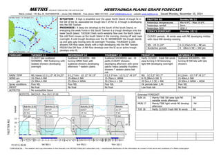
  • 1. METRIS SPECIALIST FORECASTING FOR HORTICULTURE Metris Limited – PO Box 24, FEATHERSTON – phone (06) 3086028 SITUATION - A high is straddled over the upper North Island. A trough lie in the SW of the SI, associated lee trough lies E of the SI. A trough is developing into the SW Tasman. PROGNOSIS - A deep low develops to the South of the South Island, re energizing the week fronts in the South Tasman is a trough develops onto the lower South Island. TUESDAY fresh north the cold front moves up the South overnight. A cold trough develops over the SI. WEDNESDAY the trough stands up and gets ugly moving onto NI overnight Thursday. THURSDAY a cold showery SW flow eases slowly with a high developing into the NW Tasma FRIDAY the SW flow. A NW flow develops over the SI as an active trough develops onto SI. FORECAST TUESDAY 11 WEDNESDAY 12 CLOUDY late scattered SHOWERS - NW freshening with isolated showers developing overnight north-westerly flow over the North Island Island in the morning, moving off east cape Scattered SHOWERS turning WNW fresh with scattered showers developing afternoon * eastern plains RAIN/ TEMP NIL traces LO 11,13° HI 24,25° 0-1,2*mm - WIND am 10-25km.h NW 20-40km.h NW pm 15-30km.h NW 25-45km.h WNW Spray conditions Poor NIL Poor NIL FROST No frost No frost BOTRYTIS No susceptible tissue - Rainfall 15 10 5 2 1 TROTTER RD BOTRYTIS - BACCHUS - Mon 10/11 07:00 Botrytis (0.8) 7.9 C° 25 hrs 5.8 mm 07/11 23:00 Botrytis (0.4) 4.9 C° 14 hrs 0.2 mm 08/11 23:00 Fri 07/11 06:00 Sat 08/11 Sun 09/11 CONFIDENCIAL – The weather and crop information in this forecast is for METRIS FORECAST subscribers only HERETAUNGA PLAINS GRAPE – Free phone 0800 372 433– email info@metris.co.nz - website www.metris.co.nz TROTTER RD Yesterdays temperatures Yesterdays rainfall Yesterdays GDD TODAY'S FORECAST re-energizing Tasman. CLOUDY periods with cloud NW develop evening NIL - HI 21- Borderline periods THURSDAY 13 FRIDAY 14 - NW Scattered SHOWERS/ rain - W partly CLOUDY showers developing afternoon with some patchy heavy possibly thundery showers * eastern plains hail risk - W winds ease with NE developing midday -24° 0-12,15km.h W > NE am Partly CLOUDY - fresh SW winds ease turning S SE becoming light NW developing overnight LO 12° HI 19° 0.5,1-5*mm - LO 9,11° HI 19° NIL - LO 2,5° HI 17° 15-35km.h WNW 8-25,28km.h SW S 30-15km.h > SW 20-5km.h S SE > NW Poor NIL Ok periods later 2,4h No frost Low frost risk - - 8 - 18km.h NE > NW pm Extended FORECAST SUN 16 Mainly FINE SW ease light NE variable winds afternoon MON 17 Mainly FINE light winds NE develop afternoon TUE 18 Partly CLOUDY fresh NW W winds 30 20 10 0 Temperature Mon 10/11 – unauthorised distribution of this information is a breach of the terms and conditions of a Metris subscript Botrytis (0.4) 6.8 C° 14 hrs 0 mm 09/11 23:00 Botrytis (101. 2C+° ) 4 hrs 0 mm FORECAST Issued Monday, November 10, 2014 Sunday 09/11 Min 4.4°C - Max 19.6°C 0mm GDD 2 Monday 10/11 SATURDAY 15 Scattered SHOWERS - NW turning W SW late with late showers ° 0-1,2mm - LO 7-9° HI 21° 15-40km.h NW 20-50km.h WNW > WSW Poor NIL No frost - Nil Nil Nil subscription