SlideShare a Scribd company logo
1 of 5
Download to read offline
General Forecast - SEPD Region
A warm day with sunny spells but there is the chance of a few showers developing during the afternoon, most likely in northern areas. The showers may be heavy and give the slight chance
of very infrequent lightning strikes. A few showers may linger into the evening, chiefly in the north once again, with the small risk of isolated lightning strikes. However, it will become dry
overnight with clear periods.
Mean Dir'n Gust Mean Dir'n Gust Mean Dir'n Gust Mean Dir'n Gust
10 W 20 15 SW 25 15 SW 20 15 SW 25
10 SW 20 15 W 25 15 SW 25 10 SW 25
5 SW 20 10 SW 25 10 W 20 10 SW 20
10 SW 10 10 SW 10 10 SW 10 10 SW 15
Snow (cm) Line Icing Height (m) Snow (cm) Line Icing Height (m) Snow (cm) Line Icing Height (m) Snow (cm) Line Icing Height (m)
0.0 Nil N/A 0.0 Nil N/A 0.0 Nil N/A 0.0 Nil N/A
Area
North East North West South East South West
Slough and West London Oxford, Reading & Melksham Aldershot & Portsmouth Poole & New Forest
Risk (RAG) Green Green Green Green
Temp (Max/Min) 25 13 23 13 24 13 23 13
Wind
06h-12h
12h-18h
18h-00h
00h-06h
Rain (mm)
06h-18h 0 - 3.1 0 - 3.9 0 - 0.8 0 - 1.2
18h-06h 0 - 2.0 0 - 2.3 0 - 0.8 0 - 1.0
Snow/Line Icing
06h-18h
18h-06h
Lightning
06h-18h 2D 2D 3 3
18h-06h 2D 2D 3 3
Scheduled Utilities Forecast - SEPD (South) - Thursday 31 Jul 2014
Day 1 of 5 (0600 Thursday 31st July to 0600 Friday 1st August)
General Forecast - SEPD Region
After a mostly fine start, a few showers are expected to break out. The showers are likely to be heavy with the risk of infrequent lightning strikes. Further showers are expected overnight
and they may merge into longer spells of rain at times. The continuing risk of infrequent lightning strikes.
Mean Dir'n Gust Mean Dir'n Gust Mean Dir'n Gust Mean Dir'n Gust
10 S 20 15 S 20 15 SW 25 15 S 20
10 S 20 10 S 20 15 S 25 10 S 25
5 SE 15 10 E 20 15 S 25 10 S 20
5 E 10 5 SW 15 10 S 25 10 S 15
Snow (cm) Line Icing Height (m) Snow (cm) Line Icing Height (m) Snow (cm) Line Icing Height (m) Snow (cm) Line Icing Height (m)
0.0 Nil N/A 0.0 Nil N/A 0.0 Nil N/A 0.0 Nil N/A
Area
North East North West South East South West
Slough and West London Oxford, Reading & Melksham Aldershot & Portsmouth Poole & New Forest
Risk (RAG) Green Green Green Green
Temp (Max/Min) 24 13 23 13 23 13 22 14
Wind
06h-12h
12h-18h
18h-00h
00h-06h
Rain (mm)
06h-18h 0 - 3.0 0.6 - 4.0 0 - 2.8 0.1 - 3.4
18h-06h 0.8 - 5.3 1.8 - 7.0 0.7 - 4.4 1.5 - 7.0
Snow/Line Icing
06h-18h
18h-06h
Lightning
06h-18h 2C 2C 2C 2C
18h-06h 2C 2C 2C 2C
Day 2 of 5 (0600 Friday 1st August to 0600 Saturday 2nd August)
General Forecast - SEPD Region
Low pressure centred over the UK is expected to give
an unsettled day with showers or longer outbreaks of
rain, many of these heavy and giving the risk of
infrequent lightning strikes. Some model output
suggests that a few intense thunderstorms could
break out to give frequent lightning strikes and
downpours, but there is a lot of uncertainty at this
stage. The showers/rain/thunderstorms should move
away to the north overnight.
General Forecast - SEPD Region
A mostly fine day with sunny spells and just the odd
shower possible. Any showers will die out through the
evening to leave a dry night with clear periods.
General Forecast - SEPD Region
A ridge of high pressure is expected to give a largely
fine and warm day with sunny intervals. However, a
frontal system may push showery rain in from the
west overnight.
Mean Dir'n Gust Mean Dir'n Gust Mean Dir'n Gust
20 SW 30 25 SW 35 20 S 30
Snow (cm) Line Icing Height (m) Snow (cm) Line Icing Height (m) Snow (cm) Line Icing Height (m)
0.0 Nil N/A 0.0 Nil N/A 0.0 Nil N/A
Day 3 of 5 (0600 Saturday 2nd August to 0600
Sunday 3rd August)
Day 4 of 5 (0600 Sunday 3rd August to 0600
Monday 4th August)
Day 5 of 5 (0600 Monday 4th August to 0600
Tuesday 5th August)
Area
Day Three Day Four Day Five
SEPD Region SEPD Region SEPD Region
Risk (RAG) Green Green Green
Temp (Max/Min) 23 12 23 11 24 13
Wind
24 hours
Rain (mm) 24 hour total 24 hour total 24 hour total
24 hours 4 - 25 0 - 2 0 - 3
Snow/Line Icing
24 hours
Lightning
24 hours 2C 3 3
Days 6 to 10 (0600 Tuesday 5th August to 0600 Sunday 10th August)
Outlook
Low pressure will be the dominant feature through much of next week to give showers or longer spells of rain at times. There are some indications that pressure will build towards the
weekend to give more settled conditions, but confidence is very low at this stage.
Rainfall (mm)
12 hr (days 1 and 2) 24 hr (days 3 to 5)
>50 >50
>=25 >25
<25 <=25
Snowfall (cm)
12 hr (days 1 and 2) 24 hr (days 3 to 5)
if 24hr total >=10 >=3 >=5
>1 >=1
<=1 <1
if 24hr total >=5 >1
<=1
if 24hr total <5 any amount
Overall risk of disruption
Severe risk Red
Significant risk Amber
No risk Green
The above reflects the worst case of any of the following
Wind Gusts (mph) - 1st November - 31st March
Direction N/NE/E All other directions
>50 mph Red >70 mph Red
>40 mph Amber >50 mph Amber
<=40 mph Green <=50 mph Green
Wind Gusts (mph) - 1st April - 31st October
Direction N/NE/E All other directions
>40 mph Red >60 mph Red
>30 mph Amber >40 mph Amber
<=30 mph Green <=40 mph Green
Line icing
12 hr (days 1 and 2) 24 hr (days 3 to 5)
Severe Severe
other 12hr > Nil Moderate Moderate
other 12hr = Nil Moderate Slight
Slight Nil
Nil
Lightning risk and disruption colour code matrix
Risk level 1 A B C D
Risk level 2 A B C D
Risk level 3 A B C D
Risk level 4 A B C D
Lightning Risk Categories
1 - Lightning will almost certainly occur across the region, or is occurring
2 - Lightning is likely across the region
3 - Lightning is unlikely across the region, although convective activity or an active front is forecast
4 - Lightning is not expected to occur across the region
Lightning Intensity Index
A - Very frequent lightning strikes
B - Frequent lightning strikes
C - Infrequent lightning strikes
D - Very infrequent lightning strikes
All Temperatures in °C
All Wind speeds in MPH

More Related Content

Similar to Scheduled Utilities Forecast - SEPD (South) - Thursday 31 Jul 2014

Scheduled Utilities Forecast - SEPD (South) - Thursday 24 Jul 2014
Scheduled Utilities Forecast - SEPD (South) - Thursday 24 Jul 2014Scheduled Utilities Forecast - SEPD (South) - Thursday 24 Jul 2014
Scheduled Utilities Forecast - SEPD (South) - Thursday 24 Jul 2014MeteoGroup
 
Scheduled Utilities Forecast - SHEPD (North) - Wednesday 30 Jul 2014
Scheduled Utilities Forecast - SHEPD (North) - Wednesday 30 Jul 2014Scheduled Utilities Forecast - SHEPD (North) - Wednesday 30 Jul 2014
Scheduled Utilities Forecast - SHEPD (North) - Wednesday 30 Jul 2014MeteoGroup
 
Scheduled Utilities Forecast - SHEPD (North) - Tuesday 29 Jul 2014
Scheduled Utilities Forecast - SHEPD (North) - Tuesday 29 Jul 2014Scheduled Utilities Forecast - SHEPD (North) - Tuesday 29 Jul 2014
Scheduled Utilities Forecast - SHEPD (North) - Tuesday 29 Jul 2014MeteoGroup
 
Scheduled Utilities Forecast - SHEPD (North) - Friday 25 Jul 2014
Scheduled Utilities Forecast - SHEPD (North) - Friday 25 Jul 2014Scheduled Utilities Forecast - SHEPD (North) - Friday 25 Jul 2014
Scheduled Utilities Forecast - SHEPD (North) - Friday 25 Jul 2014MeteoGroup
 
Scheduled Utilities Forecast - SHEPD (North) - Sunday 27 Jul 2014
Scheduled Utilities Forecast - SHEPD (North) - Sunday 27 Jul 2014Scheduled Utilities Forecast - SHEPD (North) - Sunday 27 Jul 2014
Scheduled Utilities Forecast - SHEPD (North) - Sunday 27 Jul 2014MeteoGroup
 
Scheduled Utilities Forecast - SHEPD (North) - Monday 28 Jul 2014
Scheduled Utilities Forecast - SHEPD (North) - Monday 28 Jul 2014Scheduled Utilities Forecast - SHEPD (North) - Monday 28 Jul 2014
Scheduled Utilities Forecast - SHEPD (North) - Monday 28 Jul 2014MeteoGroup
 
Scheduled Utilities Forecast - SHEPD (North) - Saturday 26 Jul 2014
Scheduled Utilities Forecast - SHEPD (North) - Saturday 26 Jul 2014Scheduled Utilities Forecast - SHEPD (North) - Saturday 26 Jul 2014
Scheduled Utilities Forecast - SHEPD (North) - Saturday 26 Jul 2014MeteoGroup
 
Trt gr nov10 - copy
Trt gr nov10 - copyTrt gr nov10 - copy
Trt gr nov10 - copyfeatop1
 
Trt gr nov10 - copy
Trt gr nov10 - copyTrt gr nov10 - copy
Trt gr nov10 - copyfeatop1
 
Event Presentation: Weather forecasting: It's the BOM
Event Presentation: Weather forecasting: It's the BOMEvent Presentation: Weather forecasting: It's the BOM
Event Presentation: Weather forecasting: It's the BOMRiAus
 
Media Outreach
Media OutreachMedia Outreach
Media OutreachJuiceman
 

Similar to Scheduled Utilities Forecast - SEPD (South) - Thursday 31 Jul 2014 (16)

Scheduled Utilities Forecast - SEPD (South) - Thursday 24 Jul 2014
Scheduled Utilities Forecast - SEPD (South) - Thursday 24 Jul 2014Scheduled Utilities Forecast - SEPD (South) - Thursday 24 Jul 2014
Scheduled Utilities Forecast - SEPD (South) - Thursday 24 Jul 2014
 
Scheduled Utilities Forecast - SHEPD (North) - Wednesday 30 Jul 2014
Scheduled Utilities Forecast - SHEPD (North) - Wednesday 30 Jul 2014Scheduled Utilities Forecast - SHEPD (North) - Wednesday 30 Jul 2014
Scheduled Utilities Forecast - SHEPD (North) - Wednesday 30 Jul 2014
 
Scheduled Utilities Forecast - SHEPD (North) - Tuesday 29 Jul 2014
Scheduled Utilities Forecast - SHEPD (North) - Tuesday 29 Jul 2014Scheduled Utilities Forecast - SHEPD (North) - Tuesday 29 Jul 2014
Scheduled Utilities Forecast - SHEPD (North) - Tuesday 29 Jul 2014
 
Scheduled Utilities Forecast - SHEPD (North) - Friday 25 Jul 2014
Scheduled Utilities Forecast - SHEPD (North) - Friday 25 Jul 2014Scheduled Utilities Forecast - SHEPD (North) - Friday 25 Jul 2014
Scheduled Utilities Forecast - SHEPD (North) - Friday 25 Jul 2014
 
Scheduled Utilities Forecast - SHEPD (North) - Sunday 27 Jul 2014
Scheduled Utilities Forecast - SHEPD (North) - Sunday 27 Jul 2014Scheduled Utilities Forecast - SHEPD (North) - Sunday 27 Jul 2014
Scheduled Utilities Forecast - SHEPD (North) - Sunday 27 Jul 2014
 
Scheduled Utilities Forecast - SHEPD (North) - Monday 28 Jul 2014
Scheduled Utilities Forecast - SHEPD (North) - Monday 28 Jul 2014Scheduled Utilities Forecast - SHEPD (North) - Monday 28 Jul 2014
Scheduled Utilities Forecast - SHEPD (North) - Monday 28 Jul 2014
 
Scheduled Utilities Forecast - SHEPD (North) - Saturday 26 Jul 2014
Scheduled Utilities Forecast - SHEPD (North) - Saturday 26 Jul 2014Scheduled Utilities Forecast - SHEPD (North) - Saturday 26 Jul 2014
Scheduled Utilities Forecast - SHEPD (North) - Saturday 26 Jul 2014
 
Weekly weather update
Weekly weather updateWeekly weather update
Weekly weather update
 
Trt gr nov10 - copy
Trt gr nov10 - copyTrt gr nov10 - copy
Trt gr nov10 - copy
 
Trt gr nov10 - copy
Trt gr nov10 - copyTrt gr nov10 - copy
Trt gr nov10 - copy
 
Event Presentation: Weather forecasting: It's the BOM
Event Presentation: Weather forecasting: It's the BOMEvent Presentation: Weather forecasting: It's the BOM
Event Presentation: Weather forecasting: It's the BOM
 
Weather Threat Brief 12-6-13
Weather Threat Brief 12-6-13Weather Threat Brief 12-6-13
Weather Threat Brief 12-6-13
 
Media Outreach
Media OutreachMedia Outreach
Media Outreach
 
2019-2020 NWS Winter Outlook
2019-2020 NWS Winter Outlook2019-2020 NWS Winter Outlook
2019-2020 NWS Winter Outlook
 
Major Winter Storm Update Feb 1-2
Major Winter Storm Update Feb 1-2Major Winter Storm Update Feb 1-2
Major Winter Storm Update Feb 1-2
 
AEG Presentation
AEG PresentationAEG Presentation
AEG Presentation
 

Recently uploaded

Horizon Net Zero Dawn – keynote slides by Ben Abraham
Horizon Net Zero Dawn – keynote slides by Ben AbrahamHorizon Net Zero Dawn – keynote slides by Ben Abraham
Horizon Net Zero Dawn – keynote slides by Ben Abrahamssuserbb03ff
 
VIP Call Girls Service Tolichowki Hyderabad Call +91-8250192130
VIP Call Girls Service Tolichowki Hyderabad Call +91-8250192130VIP Call Girls Service Tolichowki Hyderabad Call +91-8250192130
VIP Call Girls Service Tolichowki Hyderabad Call +91-8250192130Suhani Kapoor
 
(ZARA) Call Girls Talegaon Dabhade ( 7001035870 ) HI-Fi Pune Escorts Service
(ZARA) Call Girls Talegaon Dabhade ( 7001035870 ) HI-Fi Pune Escorts Service(ZARA) Call Girls Talegaon Dabhade ( 7001035870 ) HI-Fi Pune Escorts Service
(ZARA) Call Girls Talegaon Dabhade ( 7001035870 ) HI-Fi Pune Escorts Serviceranjana rawat
 
Call Girls Mumbai Gayatri 8617697112 Independent Escort Service Mumbai
Call Girls Mumbai Gayatri 8617697112 Independent Escort Service MumbaiCall Girls Mumbai Gayatri 8617697112 Independent Escort Service Mumbai
Call Girls Mumbai Gayatri 8617697112 Independent Escort Service MumbaiCall girls in Ahmedabad High profile
 
NO1 Verified kala jadu karne wale ka contact number kala jadu karne wale baba...
NO1 Verified kala jadu karne wale ka contact number kala jadu karne wale baba...NO1 Verified kala jadu karne wale ka contact number kala jadu karne wale baba...
NO1 Verified kala jadu karne wale ka contact number kala jadu karne wale baba...Amil baba
 
BOOK Call Girls in (Dwarka) CALL | 8377087607 Delhi Escorts Services
BOOK Call Girls in (Dwarka) CALL | 8377087607 Delhi Escorts ServicesBOOK Call Girls in (Dwarka) CALL | 8377087607 Delhi Escorts Services
BOOK Call Girls in (Dwarka) CALL | 8377087607 Delhi Escorts Servicesdollysharma2066
 
Booking open Available Pune Call Girls Parvati Darshan 6297143586 Call Hot I...
Booking open Available Pune Call Girls Parvati Darshan  6297143586 Call Hot I...Booking open Available Pune Call Girls Parvati Darshan  6297143586 Call Hot I...
Booking open Available Pune Call Girls Parvati Darshan 6297143586 Call Hot I...Call Girls in Nagpur High Profile
 
webinaire-green-mirror-episode-2-Smart contracts and virtual purchase agreeme...
webinaire-green-mirror-episode-2-Smart contracts and virtual purchase agreeme...webinaire-green-mirror-episode-2-Smart contracts and virtual purchase agreeme...
webinaire-green-mirror-episode-2-Smart contracts and virtual purchase agreeme...Cluster TWEED
 
(ANIKA) Call Girls Wagholi ( 7001035870 ) HI-Fi Pune Escorts Service
(ANIKA) Call Girls Wagholi ( 7001035870 ) HI-Fi Pune Escorts Service(ANIKA) Call Girls Wagholi ( 7001035870 ) HI-Fi Pune Escorts Service
(ANIKA) Call Girls Wagholi ( 7001035870 ) HI-Fi Pune Escorts Serviceranjana rawat
 
VIP Kolkata Call Girl Kalighat 👉 8250192130 Available With Room
VIP Kolkata Call Girl Kalighat 👉 8250192130  Available With RoomVIP Kolkata Call Girl Kalighat 👉 8250192130  Available With Room
VIP Kolkata Call Girl Kalighat 👉 8250192130 Available With Roomdivyansh0kumar0
 
(ANAYA) Call Girls Hadapsar ( 7001035870 ) HI-Fi Pune Escorts Service
(ANAYA) Call Girls Hadapsar ( 7001035870 ) HI-Fi Pune Escorts Service(ANAYA) Call Girls Hadapsar ( 7001035870 ) HI-Fi Pune Escorts Service
(ANAYA) Call Girls Hadapsar ( 7001035870 ) HI-Fi Pune Escorts Serviceranjana rawat
 
Contact Number Call Girls Service In Goa 9316020077 Goa Call Girls Service
Contact Number Call Girls Service In Goa  9316020077 Goa  Call Girls ServiceContact Number Call Girls Service In Goa  9316020077 Goa  Call Girls Service
Contact Number Call Girls Service In Goa 9316020077 Goa Call Girls Servicesexy call girls service in goa
 
Call Girls In Okhla DELHI ~9654467111~ Short 1500 Night 6000
Call Girls In Okhla DELHI ~9654467111~ Short 1500 Night 6000Call Girls In Okhla DELHI ~9654467111~ Short 1500 Night 6000
Call Girls In Okhla DELHI ~9654467111~ Short 1500 Night 6000Sapana Sha
 
Call Girls Pune Airport Call Me 7737669865 Budget Friendly No Advance Booking
Call Girls Pune Airport Call Me 7737669865 Budget Friendly No Advance BookingCall Girls Pune Airport Call Me 7737669865 Budget Friendly No Advance Booking
Call Girls Pune Airport Call Me 7737669865 Budget Friendly No Advance Bookingtanu pandey
 
(RIYA) Kalyani Nagar Call Girls Just Call 7001035870 [ Cash on Delivery ] Pun...
(RIYA) Kalyani Nagar Call Girls Just Call 7001035870 [ Cash on Delivery ] Pun...(RIYA) Kalyani Nagar Call Girls Just Call 7001035870 [ Cash on Delivery ] Pun...
(RIYA) Kalyani Nagar Call Girls Just Call 7001035870 [ Cash on Delivery ] Pun...ranjana rawat
 
VIP Call Girls Mahadevpur Colony ( Hyderabad ) Phone 8250192130 | ₹5k To 25k ...
VIP Call Girls Mahadevpur Colony ( Hyderabad ) Phone 8250192130 | ₹5k To 25k ...VIP Call Girls Mahadevpur Colony ( Hyderabad ) Phone 8250192130 | ₹5k To 25k ...
VIP Call Girls Mahadevpur Colony ( Hyderabad ) Phone 8250192130 | ₹5k To 25k ...Suhani Kapoor
 

Recently uploaded (20)

Horizon Net Zero Dawn – keynote slides by Ben Abraham
Horizon Net Zero Dawn – keynote slides by Ben AbrahamHorizon Net Zero Dawn – keynote slides by Ben Abraham
Horizon Net Zero Dawn – keynote slides by Ben Abraham
 
VIP Call Girls Service Tolichowki Hyderabad Call +91-8250192130
VIP Call Girls Service Tolichowki Hyderabad Call +91-8250192130VIP Call Girls Service Tolichowki Hyderabad Call +91-8250192130
VIP Call Girls Service Tolichowki Hyderabad Call +91-8250192130
 
Escort Service Call Girls In Shakti Nagar, 99530°56974 Delhi NCR
Escort Service Call Girls In Shakti Nagar, 99530°56974 Delhi NCREscort Service Call Girls In Shakti Nagar, 99530°56974 Delhi NCR
Escort Service Call Girls In Shakti Nagar, 99530°56974 Delhi NCR
 
(ZARA) Call Girls Talegaon Dabhade ( 7001035870 ) HI-Fi Pune Escorts Service
(ZARA) Call Girls Talegaon Dabhade ( 7001035870 ) HI-Fi Pune Escorts Service(ZARA) Call Girls Talegaon Dabhade ( 7001035870 ) HI-Fi Pune Escorts Service
(ZARA) Call Girls Talegaon Dabhade ( 7001035870 ) HI-Fi Pune Escorts Service
 
Green Banking
Green Banking Green Banking
Green Banking
 
Call Girls Mumbai Gayatri 8617697112 Independent Escort Service Mumbai
Call Girls Mumbai Gayatri 8617697112 Independent Escort Service MumbaiCall Girls Mumbai Gayatri 8617697112 Independent Escort Service Mumbai
Call Girls Mumbai Gayatri 8617697112 Independent Escort Service Mumbai
 
NO1 Verified kala jadu karne wale ka contact number kala jadu karne wale baba...
NO1 Verified kala jadu karne wale ka contact number kala jadu karne wale baba...NO1 Verified kala jadu karne wale ka contact number kala jadu karne wale baba...
NO1 Verified kala jadu karne wale ka contact number kala jadu karne wale baba...
 
Sustainable Packaging
Sustainable PackagingSustainable Packaging
Sustainable Packaging
 
Model Call Girl in Rajiv Chowk Delhi reach out to us at 🔝9953056974🔝
Model Call Girl in Rajiv Chowk Delhi reach out to us at 🔝9953056974🔝Model Call Girl in Rajiv Chowk Delhi reach out to us at 🔝9953056974🔝
Model Call Girl in Rajiv Chowk Delhi reach out to us at 🔝9953056974🔝
 
BOOK Call Girls in (Dwarka) CALL | 8377087607 Delhi Escorts Services
BOOK Call Girls in (Dwarka) CALL | 8377087607 Delhi Escorts ServicesBOOK Call Girls in (Dwarka) CALL | 8377087607 Delhi Escorts Services
BOOK Call Girls in (Dwarka) CALL | 8377087607 Delhi Escorts Services
 
Booking open Available Pune Call Girls Parvati Darshan 6297143586 Call Hot I...
Booking open Available Pune Call Girls Parvati Darshan  6297143586 Call Hot I...Booking open Available Pune Call Girls Parvati Darshan  6297143586 Call Hot I...
Booking open Available Pune Call Girls Parvati Darshan 6297143586 Call Hot I...
 
webinaire-green-mirror-episode-2-Smart contracts and virtual purchase agreeme...
webinaire-green-mirror-episode-2-Smart contracts and virtual purchase agreeme...webinaire-green-mirror-episode-2-Smart contracts and virtual purchase agreeme...
webinaire-green-mirror-episode-2-Smart contracts and virtual purchase agreeme...
 
(ANIKA) Call Girls Wagholi ( 7001035870 ) HI-Fi Pune Escorts Service
(ANIKA) Call Girls Wagholi ( 7001035870 ) HI-Fi Pune Escorts Service(ANIKA) Call Girls Wagholi ( 7001035870 ) HI-Fi Pune Escorts Service
(ANIKA) Call Girls Wagholi ( 7001035870 ) HI-Fi Pune Escorts Service
 
VIP Kolkata Call Girl Kalighat 👉 8250192130 Available With Room
VIP Kolkata Call Girl Kalighat 👉 8250192130  Available With RoomVIP Kolkata Call Girl Kalighat 👉 8250192130  Available With Room
VIP Kolkata Call Girl Kalighat 👉 8250192130 Available With Room
 
(ANAYA) Call Girls Hadapsar ( 7001035870 ) HI-Fi Pune Escorts Service
(ANAYA) Call Girls Hadapsar ( 7001035870 ) HI-Fi Pune Escorts Service(ANAYA) Call Girls Hadapsar ( 7001035870 ) HI-Fi Pune Escorts Service
(ANAYA) Call Girls Hadapsar ( 7001035870 ) HI-Fi Pune Escorts Service
 
Contact Number Call Girls Service In Goa 9316020077 Goa Call Girls Service
Contact Number Call Girls Service In Goa  9316020077 Goa  Call Girls ServiceContact Number Call Girls Service In Goa  9316020077 Goa  Call Girls Service
Contact Number Call Girls Service In Goa 9316020077 Goa Call Girls Service
 
Call Girls In Okhla DELHI ~9654467111~ Short 1500 Night 6000
Call Girls In Okhla DELHI ~9654467111~ Short 1500 Night 6000Call Girls In Okhla DELHI ~9654467111~ Short 1500 Night 6000
Call Girls In Okhla DELHI ~9654467111~ Short 1500 Night 6000
 
Call Girls Pune Airport Call Me 7737669865 Budget Friendly No Advance Booking
Call Girls Pune Airport Call Me 7737669865 Budget Friendly No Advance BookingCall Girls Pune Airport Call Me 7737669865 Budget Friendly No Advance Booking
Call Girls Pune Airport Call Me 7737669865 Budget Friendly No Advance Booking
 
(RIYA) Kalyani Nagar Call Girls Just Call 7001035870 [ Cash on Delivery ] Pun...
(RIYA) Kalyani Nagar Call Girls Just Call 7001035870 [ Cash on Delivery ] Pun...(RIYA) Kalyani Nagar Call Girls Just Call 7001035870 [ Cash on Delivery ] Pun...
(RIYA) Kalyani Nagar Call Girls Just Call 7001035870 [ Cash on Delivery ] Pun...
 
VIP Call Girls Mahadevpur Colony ( Hyderabad ) Phone 8250192130 | ₹5k To 25k ...
VIP Call Girls Mahadevpur Colony ( Hyderabad ) Phone 8250192130 | ₹5k To 25k ...VIP Call Girls Mahadevpur Colony ( Hyderabad ) Phone 8250192130 | ₹5k To 25k ...
VIP Call Girls Mahadevpur Colony ( Hyderabad ) Phone 8250192130 | ₹5k To 25k ...
 

Scheduled Utilities Forecast - SEPD (South) - Thursday 31 Jul 2014

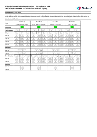
  • 1. General Forecast - SEPD Region A warm day with sunny spells but there is the chance of a few showers developing during the afternoon, most likely in northern areas. The showers may be heavy and give the slight chance of very infrequent lightning strikes. A few showers may linger into the evening, chiefly in the north once again, with the small risk of isolated lightning strikes. However, it will become dry overnight with clear periods. Mean Dir'n Gust Mean Dir'n Gust Mean Dir'n Gust Mean Dir'n Gust 10 W 20 15 SW 25 15 SW 20 15 SW 25 10 SW 20 15 W 25 15 SW 25 10 SW 25 5 SW 20 10 SW 25 10 W 20 10 SW 20 10 SW 10 10 SW 10 10 SW 10 10 SW 15 Snow (cm) Line Icing Height (m) Snow (cm) Line Icing Height (m) Snow (cm) Line Icing Height (m) Snow (cm) Line Icing Height (m) 0.0 Nil N/A 0.0 Nil N/A 0.0 Nil N/A 0.0 Nil N/A 0.0 Nil N/A 0.0 Nil N/A 0.0 Nil N/A 0.0 Nil N/A Area North East North West South East South West Slough and West London Oxford, Reading & Melksham Aldershot & Portsmouth Poole & New Forest Risk (RAG) Green Green Green Green Temp (Max/Min) 25 13 23 13 24 13 23 13 Wind 06h-12h 12h-18h 18h-00h 00h-06h Rain (mm) 06h-18h 0 - 3.1 0 - 3.9 0 - 0.8 0 - 1.2 18h-06h 0 - 2.0 0 - 2.3 0 - 0.8 0 - 1.0 Snow/Line Icing 06h-18h 18h-06h Lightning 06h-18h 2D 2D 3 3 18h-06h 2D 2D 3 3 Scheduled Utilities Forecast - SEPD (South) - Thursday 31 Jul 2014 Day 1 of 5 (0600 Thursday 31st July to 0600 Friday 1st August)
  • 2. General Forecast - SEPD Region After a mostly fine start, a few showers are expected to break out. The showers are likely to be heavy with the risk of infrequent lightning strikes. Further showers are expected overnight and they may merge into longer spells of rain at times. The continuing risk of infrequent lightning strikes. Mean Dir'n Gust Mean Dir'n Gust Mean Dir'n Gust Mean Dir'n Gust 10 S 20 15 S 20 15 SW 25 15 S 20 10 S 20 10 S 20 15 S 25 10 S 25 5 SE 15 10 E 20 15 S 25 10 S 20 5 E 10 5 SW 15 10 S 25 10 S 15 Snow (cm) Line Icing Height (m) Snow (cm) Line Icing Height (m) Snow (cm) Line Icing Height (m) Snow (cm) Line Icing Height (m) 0.0 Nil N/A 0.0 Nil N/A 0.0 Nil N/A 0.0 Nil N/A 0.0 Nil N/A 0.0 Nil N/A 0.0 Nil N/A 0.0 Nil N/A Area North East North West South East South West Slough and West London Oxford, Reading & Melksham Aldershot & Portsmouth Poole & New Forest Risk (RAG) Green Green Green Green Temp (Max/Min) 24 13 23 13 23 13 22 14 Wind 06h-12h 12h-18h 18h-00h 00h-06h Rain (mm) 06h-18h 0 - 3.0 0.6 - 4.0 0 - 2.8 0.1 - 3.4 18h-06h 0.8 - 5.3 1.8 - 7.0 0.7 - 4.4 1.5 - 7.0 Snow/Line Icing 06h-18h 18h-06h Lightning 06h-18h 2C 2C 2C 2C 18h-06h 2C 2C 2C 2C Day 2 of 5 (0600 Friday 1st August to 0600 Saturday 2nd August)
  • 3. General Forecast - SEPD Region Low pressure centred over the UK is expected to give an unsettled day with showers or longer outbreaks of rain, many of these heavy and giving the risk of infrequent lightning strikes. Some model output suggests that a few intense thunderstorms could break out to give frequent lightning strikes and downpours, but there is a lot of uncertainty at this stage. The showers/rain/thunderstorms should move away to the north overnight. General Forecast - SEPD Region A mostly fine day with sunny spells and just the odd shower possible. Any showers will die out through the evening to leave a dry night with clear periods. General Forecast - SEPD Region A ridge of high pressure is expected to give a largely fine and warm day with sunny intervals. However, a frontal system may push showery rain in from the west overnight. Mean Dir'n Gust Mean Dir'n Gust Mean Dir'n Gust 20 SW 30 25 SW 35 20 S 30 Snow (cm) Line Icing Height (m) Snow (cm) Line Icing Height (m) Snow (cm) Line Icing Height (m) 0.0 Nil N/A 0.0 Nil N/A 0.0 Nil N/A Day 3 of 5 (0600 Saturday 2nd August to 0600 Sunday 3rd August) Day 4 of 5 (0600 Sunday 3rd August to 0600 Monday 4th August) Day 5 of 5 (0600 Monday 4th August to 0600 Tuesday 5th August) Area Day Three Day Four Day Five SEPD Region SEPD Region SEPD Region Risk (RAG) Green Green Green Temp (Max/Min) 23 12 23 11 24 13 Wind 24 hours Rain (mm) 24 hour total 24 hour total 24 hour total 24 hours 4 - 25 0 - 2 0 - 3 Snow/Line Icing 24 hours Lightning 24 hours 2C 3 3 Days 6 to 10 (0600 Tuesday 5th August to 0600 Sunday 10th August) Outlook Low pressure will be the dominant feature through much of next week to give showers or longer spells of rain at times. There are some indications that pressure will build towards the weekend to give more settled conditions, but confidence is very low at this stage.
  • 4. Rainfall (mm) 12 hr (days 1 and 2) 24 hr (days 3 to 5) >50 >50 >=25 >25 <25 <=25 Snowfall (cm) 12 hr (days 1 and 2) 24 hr (days 3 to 5) if 24hr total >=10 >=3 >=5 >1 >=1 <=1 <1 if 24hr total >=5 >1 <=1 if 24hr total <5 any amount Overall risk of disruption Severe risk Red Significant risk Amber No risk Green The above reflects the worst case of any of the following Wind Gusts (mph) - 1st November - 31st March Direction N/NE/E All other directions >50 mph Red >70 mph Red >40 mph Amber >50 mph Amber <=40 mph Green <=50 mph Green Wind Gusts (mph) - 1st April - 31st October Direction N/NE/E All other directions >40 mph Red >60 mph Red >30 mph Amber >40 mph Amber <=30 mph Green <=40 mph Green
  • 5. Line icing 12 hr (days 1 and 2) 24 hr (days 3 to 5) Severe Severe other 12hr > Nil Moderate Moderate other 12hr = Nil Moderate Slight Slight Nil Nil Lightning risk and disruption colour code matrix Risk level 1 A B C D Risk level 2 A B C D Risk level 3 A B C D Risk level 4 A B C D Lightning Risk Categories 1 - Lightning will almost certainly occur across the region, or is occurring 2 - Lightning is likely across the region 3 - Lightning is unlikely across the region, although convective activity or an active front is forecast 4 - Lightning is not expected to occur across the region Lightning Intensity Index A - Very frequent lightning strikes B - Frequent lightning strikes C - Infrequent lightning strikes D - Very infrequent lightning strikes All Temperatures in °C All Wind speeds in MPH