Scheduled Utilities Forecast - SEPD (South) - Wednesday 30 Jul 2014
•
0 likes•134 views

Day 1 of 5 (0600 Wednesday 30th July to 0600 Thursday 31st July)

Recommended
Recommended
More Related Content
Viewers also liked
Viewers also liked (20)
Similar to Scheduled Utilities Forecast - SEPD (South) - Wednesday 30 Jul 2014
Similar to Scheduled Utilities Forecast - SEPD (South) - Wednesday 30 Jul 2014 (14)
Recently uploaded
Recently uploaded (20)
Scheduled Utilities Forecast - SEPD (South) - Wednesday 30 Jul 2014
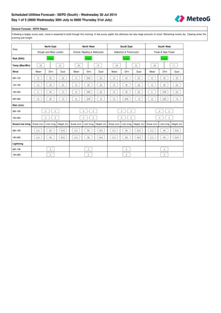
- 1. General Forecast - SEPD Region Following a largely sunny start, cloud is expected to build through this morning. A few sunny spells this afternoon but also large amounts of cloud. Remaining mostly dry. Clearing skies this evening and tonight. Mean Dir'n Gust Mean Dir'n Gust Mean Dir'n Gust Mean Dir'n Gust 10 W 20 15 SW 20 15 W 20 10 W 20 10 W 20 15 W 25 15 W 20 15 W 25 5 W 15 10 NW 25 10 W 20 5 SW 20 10 W 10 10 SW 15 10 SW 10 10 SW 10 Snow (cm) Line Icing Height (m) Snow (cm) Line Icing Height (m) Snow (cm) Line Icing Height (m) Snow (cm) Line Icing Height (m) 0.0 Nil N/A 0.0 Nil N/A 0.0 Nil N/A 0.0 Nil N/A 0.0 Nil N/A 0.0 Nil N/A 0.0 Nil N/A 0.0 Nil N/A Area North East North West South East South West Slough and West London Oxford, Reading & Melksham Aldershot & Portsmouth Poole & New Forest Risk (RAG) Green Green Green Green Temp (Max/Min) 24 12 24 12 24 12 24 11 Wind 06h-12h 12h-18h 18h-00h 00h-06h Rain (mm) 06h-18h 0 - 0 0 - 0 0 - 0 0 - 0 18h-06h 0 - 0 0 - 0 0 - 0 0 - 0 Snow/Line Icing 06h-18h 18h-06h Lightning 06h-18h 4 4 4 4 18h-06h 4 4 4 4 Scheduled Utilities Forecast - SEPD (South) - Wednesday 30 Jul 2014 Day 1 of 5 (0600 Wednesday 30th July to 0600 Thursday 31st July)
- 2. General Forecast - SEPD Region A dry and sunny start but areas of cloud will soon drift in from the north-west bringing the chance of one or two showers. South-eastern areas are most likely to escape dry. Any showers will tend to clear through the evening leaving a mostly dry night with clear spells. Mean Dir'n Gust Mean Dir'n Gust Mean Dir'n Gust Mean Dir'n Gust 10 W 20 15 SW 25 15 SW 20 15 W 20 10 SW 25 15 SW 25 15 SW 25 10 SW 25 10 SW 20 15 SW 25 10 W 20 10 SW 20 10 SW 10 15 SW 15 10 SW 10 10 SW 15 Snow (cm) Line Icing Height (m) Snow (cm) Line Icing Height (m) Snow (cm) Line Icing Height (m) Snow (cm) Line Icing Height (m) 0.0 Nil N/A 0.0 Nil N/A 0.0 Nil N/A 0.0 Nil N/A 0.0 Nil N/A 0.0 Nil N/A 0.0 Nil N/A 0.0 Nil N/A Area North East North West South East South West Slough and West London Oxford, Reading & Melksham Aldershot & Portsmouth Poole & New Forest Risk (RAG) Green Green Green Green Temp (Max/Min) 25 13 24 12 24 13 24 13 Wind 06h-12h 12h-18h 18h-00h 00h-06h Rain (mm) 06h-18h 0 - 1.0 0 - 1.0 0 - 1.0 0 - 1.0 18h-06h 0 - 0 0 - 0 0 - 0 0 - 0 Snow/Line Icing 06h-18h 18h-06h Lightning 06h-18h 3 3 3 3 18h-06h 4 4 3 4 Day 2 of 5 (0600 Thursday 31st July to 0600 Friday 1st August)
- 3. General Forecast - SEPD Region Showers developing through the morning. Further showers in to the afternoon with a growing chance of lengthier spells of rain edging in to more western areas. This rain will linger in to the night. However, only a few showers are likely in the east. There is a small risk of infrequent lightning from embedded thunderstorms in more western parts although confidence is rather low. General Forecast - SEPD Region Showery rain with infrequent lightning is possible in the morning, gradually easing away in the afternoon. Mostly dry by evening with just an odd shower possible overnight. General Forecast - SEPD Region Occasional showers but in general, plenty of dry weather with sunny or clear spells. Mean Dir'n Gust Mean Dir'n Gust Mean Dir'n Gust 20 SW 30 20 S 30 20 SW 30 Snow (cm) Line Icing Height (m) Snow (cm) Line Icing Height (m) Snow (cm) Line Icing Height (m) 0.0 Nil N/A 0.0 Nil N/A 0.0 Nil N/A Day 3 of 5 (0600 Friday 1st August to 0600 Saturday 2nd August) Day 4 of 5 (0600 Saturday 2nd August to 0600 Sunday 3rd August) Day 5 of 5 (0600 Sunday 3rd August to 0600 Monday 4th August) Area Day Three Day Four Day Five SEPD Region SEPD Region SEPD Region Risk (RAG) Green Green Green Temp (Max/Min) 24 13 24 11 24 12 Wind 24 hours Rain (mm) 24 hour total 24 hour total 24 hour total 24 hours 0 - 11 0 - 9 0 - 1 Snow/Line Icing 24 hours Lightning 24 hours 2C 2C 3 Days 6 to 10 (0600 Monday 4th August to 0600 Saturday 9th August) Outlook Low pressure is likely to dominate. Spells of rain are likely at times, interspersed with some drier periods.
- 4. Rainfall (mm) 12 hr (days 1 and 2) 24 hr (days 3 to 5) >50 >50 >=25 >25 <25 <=25 Snowfall (cm) 12 hr (days 1 and 2) 24 hr (days 3 to 5) if 24hr total >=10 >=3 >=5 >1 >=1 <=1 <1 if 24hr total >=5 >1 <=1 if 24hr total <5 any amount Overall risk of disruption Severe risk Red Significant risk Amber No risk Green The above reflects the worst case of any of the following Wind Gusts (mph) - 1st November - 31st March Direction N/NE/E All other directions >50 mph Red >70 mph Red >40 mph Amber >50 mph Amber <=40 mph Green <=50 mph Green Wind Gusts (mph) - 1st April - 31st October Direction N/NE/E All other directions >40 mph Red >60 mph Red >30 mph Amber >40 mph Amber <=30 mph Green <=40 mph Green
- 5. Line icing 12 hr (days 1 and 2) 24 hr (days 3 to 5) Severe Severe other 12hr > Nil Moderate Moderate other 12hr = Nil Moderate Slight Slight Nil Nil Lightning risk and disruption colour code matrix Risk level 1 A B C D Risk level 2 A B C D Risk level 3 A B C D Risk level 4 A B C D Lightning Risk Categories 1 - Lightning will almost certainly occur across the region, or is occurring 2 - Lightning is likely across the region 3 - Lightning is unlikely across the region, although convective activity or an active front is forecast 4 - Lightning is not expected to occur across the region Lightning Intensity Index A - Very frequent lightning strikes B - Frequent lightning strikes C - Infrequent lightning strikes D - Very infrequent lightning strikes All Temperatures in °C All Wind speeds in MPH