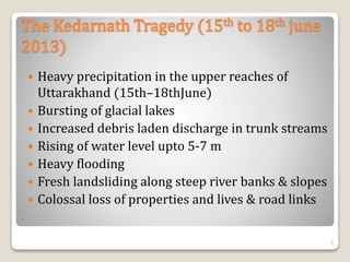
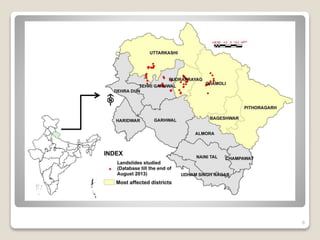
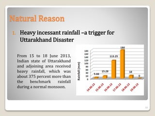
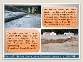
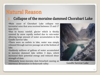
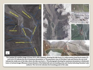
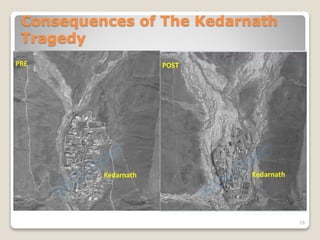
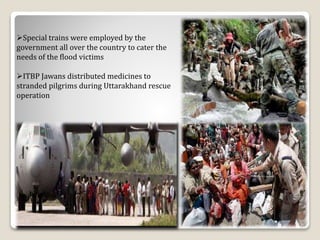
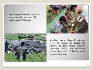
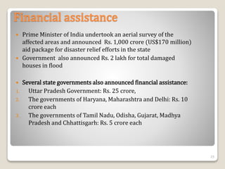
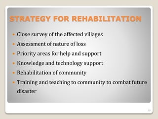
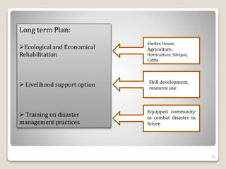
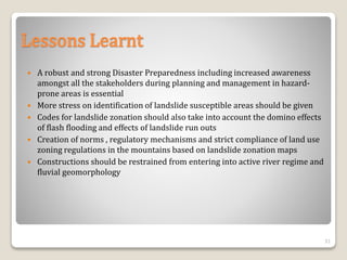
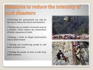
Call Girls South Delhi Delhi reach out to us at ☎ 9711199012
The Kedarnath Trajedy
1. The Kedarnath Tragedy, 2013
Vishvjeet Tholia 17WM60R01
Ritu Raj Jaitawat 17AG66R14
Surbhi Jain 17AG66R07
School of Water Resources
IIT Kharagpur 1
2. Introduction
Uttarakhand has a total area of 53,484 km²
86% is mountainous and 65% is covered by
forest
Most of Uttarakhand area is covered by high
Himalayan peaks and glaciers
It is known as the Devbhumi (literally "Land of
the Gods“)
2
3. Two of the most important rivers in Hinduism originate in
the glaciers of Uttarakhand, the Ganges at Gangotri and
the Yamuna at Yamunotri.
These two along with Badrinath and Kedarnath form
the Chota Char Dham, a holy pilgrimage for the Hindus.
Continued..
3
6. Historical Cloudburst events in Uttarakhand
2002 Cloudburst in Khetgaon (Pithoragarh) 04 persons
died.
2004 Cloudburst in Ranikhet (Almora): 01 casualty
2007 Cloudburst in Pithoragarh & Chamoli: 23 lives lost
2008 Cloudburst in Pithoragarh: 01 casualty
2009 Massive Cloudburst in Tehsil Munisyari district
Pithoragarh: 43 lives lost
2010 Massive Cloudburst Kapkot (Bageshwar): 18 school
children were buried alive and Massive Cloud burst in
Almora: 36 lives lost
6
7. The Kedarnath Tragedy (15th to 18th june
2013)
Heavy precipitation in the upper reaches of
Uttarakhand (15th–18thJune)
Bursting of glacial lakes
Increased debris laden discharge in trunk streams
Rising of water level upto 5-7 m
Heavy flooding
Fresh landsliding along steep river banks & slopes
Colossal loss of properties and lives & road links
7
10. Natural Reason
1. Heavy incessant rainfall –a trigger for
Uttarakhand Disaster
From 15 to 18 June 2013,
Indian state of Uttarakhand
and adjoining area received
heavy rainfall, which was
about 375 percent more than
the benchmark rainfall
during a normal monsoon.
10
11. The massive rainfall and cloud
burst events happened at multiple
places, including Bhagirathi basin,
Assiganga basin, Mandakini Basin,
Badrinath region, other places in
Alaknanda region from 15 June
2013 to around 18 June 2013.
This lead to melting of Chorabari
Glacier at the height of 3800
metres, and eruption of the
Mandakini River which led to
heavy floods near Kedar Dome,
Rudraprayag district,
Uttarakhand, Himachal Pradesh.
It is considered to be the largest natural disaster after tsunami occurred in 2004
11
12. •Main cause of Chorabari Lake collapse was
torrential rains that area received between 15 and 17
June 2013.
•Due to heavy rainfall, glacier which is thickly
covered by snow rapidly melted due to rain-water
allowing large amount of water accumulation in the
Gandhi Sarovar lake.
•There were no outlets in lake, water was simply
released through narrow passage sat at the bottom of
lake.
•Suddenly millions of gallons of water accumulated
in moraine dammed lake within 3 days, which
increased their potential energy and reduced shear
strength of dam.
•Ultimately loose-moraine dam breached causing an
enormous devastation in Kedarnath valley
Natural Reason
2. Collapse of the moraine dammed Chorabari Lake
Gandhi Sarovar Lake
12
13. The Landsat (8) satellite image (23 June 2013; after disaster), showing the lake burst (1), Gully erosion/cloud burst events (2)
and circle (3) indicate the site of maximum devastation. b, The panoramic view of Chorabari Lake and Glacier, the red circle
indicate the weak zone of the lake, where the lake was burst. c, The photograph showing the maximum devastation in Kedarnath
town. d, Cartosat image (Bhuwan) of post disaster of the Kedarnath and surrounding areas and clearly indicating Chorabari Lake
outburst. The red circle indicates the breaching point of the Lake. 13
16. Man-made Causes of the
disaster
Pollution and global
warming accounted for
the melting of glaciers
Violation of
environmental laws and
deforestation has also
accounted for floods.
Building of hydro
electricity plants and
increase in the
infrastructural facilities
have weaken the
mountain causing land
slides.
Laxman Jhula
Deforestation
16
17. •Ecologists point out that the huge expansion of hydro-power projects and
construction of roads to cope with lakhs of tourists in Uttarakhand and
Himachal Pradesh has compounded the scale of the disaster
•Currently 70 dams exist in the Char dham area alone. The dam
constructions involve blasting of hills which increase the risk of land slides.
•More than 220 power and mining projects are running in 14 river valleys in
Uttarakhand.
•Several rivers are being diverted through tunnels for these projects leading
to major disasters in the state.
17
19. Consequences: Human Loss
•According to the official records 400
houses were destroyed and 265 were
damaged
•4,200 villages were victims of the
flood
•6,000 people were dead,10,000 were
injured, 1800 were missing and
1,00,000 were stuck in the valley
19
20. Consequences: Economic loss
Major roads, telephone towers were
destroyed due to which communication
with the outer world was lost.
20,000 crores loss was reported,
which may be in the form of destruction
of houses, roads, cars etc.
2232 were fully damaged houses
154 bridges were Damaged
1520 roads were Damaged
Tourism constitutes about 30% of the
state’s income which was lost
All the shops and hotels were
destroyed and all roads were broken
20
21. Rescue and Relief Operation
The Army, Air Force, Navy, Indo-Tibetan
Border Police (ITBP), Border Security
Force, National Disaster Response Force
(NDRF), Public Works Department and
local administrations worked together for
quick rescue operations.
Several thousand soldiers were
deployed for the rescue missions.
Activists of political and social
organizations were also involved in the
rescue and management of relief centers.
Helicopters were used to rescue people,
but due to the rough terrain, heavy fog
and rainfall, maneuvering them was a
challenge.
21
22. By 21 June 2013, the Army had
deployed 10,000 soldiers and 11
helicopters, the Navy had sent 45
naval divers, and the Air force had
deployed 60 aircraft including 36
helicopters.
From 19 June to 30 June 2013, the
IAF airlifted a total of 18,424 people
– flying a total of 2,137 sorties and
dropping/landing a total of 3,36,930
kg of relief material and equipment.
The woods had been brought to
the site with helicopter for the
funeral of the people who died in
Uttarakhand flood
22
23. Special trains were employed by the
government all over the country to cater the
needs of the flood victims
ITBP Jawans distributed medicines to
stranded pilgrims during Uttarakhand rescue
operation
23
24. Indian army showed extreme
levels of courage in saving the
people. In this rescue mission
operation ‘Rahat’ one helicopter
got crashed and 20 bodies were
found on the site.
Local people distributed food
to rescue pilgrims near IAF
base camp in Dharasu
24
25. Financial assistance
Prime Minister of India undertook an aerial survey of the
affected areas and announced Rs. 1,000 crore (US$170 million)
aid package for disaster relief efforts in the state
Government also announced Rs. 2 lakh for total damaged
houses in flood
Several state governments also announced financial assistance:
1. Uttar Pradesh Government: Rs. 25 crore,
2. The governments of Haryana, Maharashtra and Delhi: Rs. 10
crore each
3. The governments of Tamil Nadu, Odisha, Gujarat, Madhya
Pradesh and Chhattisgarh: Rs. 5 crore each
25
26. International funds
The US Ambassador to India extended a financial help of USD
$150,000 through the United States Agency
Also US announced that the US will provide further financial aid
of USD $75,000.
26
28. STRATEGY FOR REHABILITATION
Close survey of the affected villages
Assessment of nature of loss
Priority areas for help and support
Knowledge and technology support
Rehabilitation of community
Training and teaching to community to combat future
disaster
28
29. The whole strategy must be in two major steps
Immediate Plan
Long Term Plan
Immediate Plan:
Food
Utensils, Stove etc.
Milk for children
Clothes
First aid Kit
Emergency Shelter
Sanitation
Water filters
29
30. Long term Plan:
Ecological and Economical
Rehabilitation
Livelihood support option
Training on disaster
management practices
Shelter, House,
Agriculture,
Horticulture, Silvipas,
Cattle
Skill development,
resource use
Equipped community
to combat disaster in
future
30
31. Lessons Learnt
A robust and strong Disaster Preparedness including increased awareness
amongst all the stakeholders during planning and management in hazard-
prone areas is essential
More stress on identification of landslide susceptible areas should be given
Codes for landslide zonation should also take into account the domino effects
of flash flooding and effects of landslide run outs
Creation of norms , regulatory mechanisms and strict compliance of land use
zoning regulations in the mountains based on landslide zonation maps
Constructions should be restrained from entering into active river regime and
fluvial geomorphology
31
32. Measures to reduce the intensity of
such disasters
Protecting the environment can only be
the way to reduce the risk of such disasters
Putting cap on number of tourists may be
a solution, which reduces the construction
of hotels, expansion of roads
Keeping a check on illegal constructions
and on deforestation
Alerting and transferring people to safe
zones at proper time
Training the people on how to take basic
safety measures
32