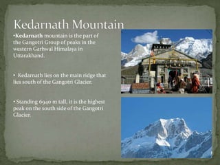
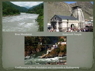
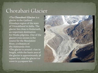
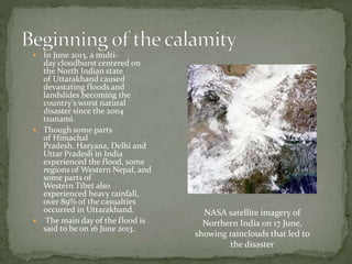
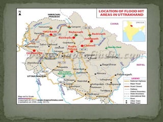
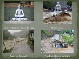
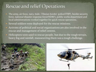
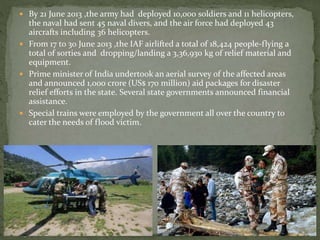
Presentation by
•Preeti Eambaram
•Sriganesh Sankar
•Vinay Thakur
•Sumeet Hande
From Students of S.I.E.S Graduate school of
technlogy,Nerul
 Kedarnath is named in the honor of King Kedar, who ruled
in Satya Yuga.
 Kedarnath is a town located in
the Indian state of Uttarakhand and has gained importance
because of Kedarnath Temple.
 Kedarnath is located in the Himalayas, about 3,583 m
above sea level near Chorabari Glacier, the head of
river Mandakini and is flanked by snow-capped peaks.
•Kedarnath mountain is the part of
the Gangotri Group of peaks in the
western Garhwal Himalaya in
Uttarakhand.
• Kedarnath lies on the main ridge that
lies south of the Gangotri Glacier.
• Standing 6940 m tall, it is the highest
peak on the south side of the Gangotri
Glacier.
 It is a Hindu temple dedicated to Bhagwan Shiva. It is on
the Garhwal Himalayan range near the Mandakini river.
 The temple is located at an height of 3,583 m (11,755 ft),
223 km from Rishikesh, on the shores of Mandakini river, a
tributary of Ganga.
 The structure is believed to have been constructed in the
8th century CE, when Adi Shankara visited.
 The temple structure has been standing erect and facing
nature's fury for the past 10 centuries and it is expected that
the structure has the endurance to remain intact in the
future as well.
River Mandakini Kedarnath Temple
Confluence of River Mandakini and Alaknanda at Rudraprayag
•The Chorabari Glacier is a
glacier in the Garhwal
Himalaya region of the state
of Uttarakhand in India. The
glacier lies close to Kedarnath,
an important destination
for Hindu pilgrims. One of the
glacier's two snouts is the
source for the Mandakini
River, a tributary of
the Alaknanda river.
•The glacier is around 7 km in
length, while the basin area of
the glacier is approximately 38
square km and the glacier ice
cover is 5.9 square km.
 In June 2013, a multi-
day cloudburst centered on
the North Indian state
of Uttarakhand caused
devastating floods and
landslides becoming the
country's worst natural
disaster since the 2004
tsunami.
 Though some parts
of Himachal
Pradesh, Haryana, Delhi and
Uttar Pradesh in India
experienced the flood, some
regions of Western Nepal, and
some parts of
Western Tibet also
experienced heavy rainfall,
over 89% of the casualties
occurred in Uttarakhand.
 The main day of the flood is
said to be on 16 June 2013.
NASA satellite imagery of
Northern India on 17 June,
showing rainclouds that led to
the disaster
 From 14 to 17 June 2013, the Indian state of Uttarakhand and adjoining
areas received heavy rainfall, which was about 375% more than the
benchmark rainfall during a normal monsoon.
 This caused the melting of Chorabari Glacier at the height of 3800
meters, and eruption of the Mandakini River which led to heavy floods
near Gobindghat, Kedar Dome, Rudraprayag district, Uttarakhand,
Himachal Pradesh and Western Nepal, and acute rainfall in other
nearby regions of Delhi, Haryana, Uttar Pradesh and some parts of
Tibet.
Satellite image (Pre-flood) Satellite image (Post-flood)
 Melting of glaciers, because of global warming has been of the reasons.
Pollution and the global warming accounted for the melting of glaciers.
 Violation of environmental laws and deforestation has also accounted for
floods.
 Building of hydroelectricity plants and increase in the infrastructure
facilities have weaken the mountains which caused landslides.
 Ecologists point out that the huge expansion of hydro –power projects
and construction of roads to cope with the lakhs of tourists in
Uttarakhand and Himachal Pradesh has compounded the scale of
disaster .
 Currently 70 dams exists in char dham area alone. The dam
construction involve blasting of hills which increase the risk of
landslide.
 More than 220 power and mining projects are running in 14 river
valleys in Uttarakhand.
 Several rivers are being diverted through tunnels for these projects
leading to major disasters in this state.
 As of 16 July 2013, according to figures provided by the Uttarakhand
government, more than 5,700 people were "presumed dead.“This total
included 934 local residents.
 Landslides, due to the floods, damaged several houses and structures,
killing those who were trapped.
 Entire villages and settlements such as Gaurikund and the market town
of Ram Bada, a transition point to Kedarnath, have been obliterated,
while the market town of Sonprayag suffered heavy damage and loss of
lives.
 Over 70,000 people were stuck in various regions because of damaged
or blocked roads.
Some were lucky to get their
loved ones back….
While some were not…
 On 18 June, more than 12,000 pilgrims were stranded at Badrinath, the
popular pilgrimage center located on the banks of the Alaknanda River.
 Bodies of people washed away in Uttarakhand were found in distant
places like Bijnor, Allahabad and Bulandshahr in Uttar Pradesh.
 Searching for bodies who died during the extreme natural fury of June
in Kedar valley continued for several months and even as late as
September, 2013, about 556 bodies were found out of which 166 bodies
were found in highly decomposed state during fourth round of search
operations.
 National Highway 58, an important artery connecting the region was
also washed away near Jyotirmath and in many other places.
 Major roads and telephone towers were destroyed due to which
communication with outer world was lost.
 According to the official records and reports 400 houses were destroyed
and 270 were damaged.
 Tourism constitutes about 30% of states income which was lost.
 All the shops, hotels and houses were destroyed all were broken.
Statue of Lord Shiv Before the flood. During floods
Roads got destroyed. Vehicles got flown away in the
 The army, air force, navy, Indo –Tibetan border police(ITBP), border security
force, national disaster response force(NDRF), public works department and
local administrations worked together for quick rescue operations.
 Several soldiers were deployed for the rescue missions.
 Activists of political and social organizations are also involved in the
rescue and management of relief centres.
 Helicopters were used to rescue people, but due to the rough terrain,
heavy fog and rainfall, manoeuvring them was a tough challenge.
 By 21 June 2013 ,the army had deployed 10,000 soldiers and 11 helicopters,
the naval had sent 45 naval divers, and the air force had deployed 43
aircrafts including 36 helicopters.
 From 17 to 30 June 2013 ,the IAF airlifted a total of 18,424 people-flying a
total of sorties and dropping/landing a 3,36,930 kg of relief material and
equipment.
 Prime minister of India undertook an aerial survey of the affected areas
and announced 1,000 crore (US$ 170 million) aid packages for disaster
relief efforts in the state. Several state governments announced financial
assistance.
 Special trains were employed by the government all over the country to
cater the needs of flood victim.
 Protecting the environment can only be the way to
reduce the risk of such disasters.
 Putting cap on number of tourist may be a solution,
which reduces the construction of hotels, expansion of
roads.
 Keeping a check on illegal constructions and on
deforestations.
•Using latest equipments to predict the
probability of heavy rains.
•Alerting and transferring people to safe zone at
proper time.
•Training to people on how to take basic safety
measures.
Kedarnath cloudburst

Kedarnath cloudburst

  • 1.
    Presentation by •Preeti Eambaram •SriganeshSankar •Vinay Thakur •Sumeet Hande From Students of S.I.E.S Graduate school of technlogy,Nerul
  • 2.
     Kedarnath isnamed in the honor of King Kedar, who ruled in Satya Yuga.  Kedarnath is a town located in the Indian state of Uttarakhand and has gained importance because of Kedarnath Temple.  Kedarnath is located in the Himalayas, about 3,583 m above sea level near Chorabari Glacier, the head of river Mandakini and is flanked by snow-capped peaks.
  • 3.
    •Kedarnath mountain isthe part of the Gangotri Group of peaks in the western Garhwal Himalaya in Uttarakhand. • Kedarnath lies on the main ridge that lies south of the Gangotri Glacier. • Standing 6940 m tall, it is the highest peak on the south side of the Gangotri Glacier.
  • 4.
     It isa Hindu temple dedicated to Bhagwan Shiva. It is on the Garhwal Himalayan range near the Mandakini river.  The temple is located at an height of 3,583 m (11,755 ft), 223 km from Rishikesh, on the shores of Mandakini river, a tributary of Ganga.  The structure is believed to have been constructed in the 8th century CE, when Adi Shankara visited.  The temple structure has been standing erect and facing nature's fury for the past 10 centuries and it is expected that the structure has the endurance to remain intact in the future as well.
  • 5.
    River Mandakini KedarnathTemple Confluence of River Mandakini and Alaknanda at Rudraprayag
  • 6.
    •The Chorabari Glacieris a glacier in the Garhwal Himalaya region of the state of Uttarakhand in India. The glacier lies close to Kedarnath, an important destination for Hindu pilgrims. One of the glacier's two snouts is the source for the Mandakini River, a tributary of the Alaknanda river. •The glacier is around 7 km in length, while the basin area of the glacier is approximately 38 square km and the glacier ice cover is 5.9 square km.
  • 7.
     In June2013, a multi- day cloudburst centered on the North Indian state of Uttarakhand caused devastating floods and landslides becoming the country's worst natural disaster since the 2004 tsunami.  Though some parts of Himachal Pradesh, Haryana, Delhi and Uttar Pradesh in India experienced the flood, some regions of Western Nepal, and some parts of Western Tibet also experienced heavy rainfall, over 89% of the casualties occurred in Uttarakhand.  The main day of the flood is said to be on 16 June 2013. NASA satellite imagery of Northern India on 17 June, showing rainclouds that led to the disaster
  • 9.
     From 14to 17 June 2013, the Indian state of Uttarakhand and adjoining areas received heavy rainfall, which was about 375% more than the benchmark rainfall during a normal monsoon.  This caused the melting of Chorabari Glacier at the height of 3800 meters, and eruption of the Mandakini River which led to heavy floods near Gobindghat, Kedar Dome, Rudraprayag district, Uttarakhand, Himachal Pradesh and Western Nepal, and acute rainfall in other nearby regions of Delhi, Haryana, Uttar Pradesh and some parts of Tibet. Satellite image (Pre-flood) Satellite image (Post-flood)
  • 10.
     Melting ofglaciers, because of global warming has been of the reasons. Pollution and the global warming accounted for the melting of glaciers.  Violation of environmental laws and deforestation has also accounted for floods.  Building of hydroelectricity plants and increase in the infrastructure facilities have weaken the mountains which caused landslides.
  • 11.
     Ecologists pointout that the huge expansion of hydro –power projects and construction of roads to cope with the lakhs of tourists in Uttarakhand and Himachal Pradesh has compounded the scale of disaster .  Currently 70 dams exists in char dham area alone. The dam construction involve blasting of hills which increase the risk of landslide.  More than 220 power and mining projects are running in 14 river valleys in Uttarakhand.  Several rivers are being diverted through tunnels for these projects leading to major disasters in this state.
  • 12.
     As of16 July 2013, according to figures provided by the Uttarakhand government, more than 5,700 people were "presumed dead.“This total included 934 local residents.  Landslides, due to the floods, damaged several houses and structures, killing those who were trapped.  Entire villages and settlements such as Gaurikund and the market town of Ram Bada, a transition point to Kedarnath, have been obliterated, while the market town of Sonprayag suffered heavy damage and loss of lives.  Over 70,000 people were stuck in various regions because of damaged or blocked roads.
  • 13.
    Some were luckyto get their loved ones back…. While some were not…
  • 14.
     On 18June, more than 12,000 pilgrims were stranded at Badrinath, the popular pilgrimage center located on the banks of the Alaknanda River.  Bodies of people washed away in Uttarakhand were found in distant places like Bijnor, Allahabad and Bulandshahr in Uttar Pradesh.  Searching for bodies who died during the extreme natural fury of June in Kedar valley continued for several months and even as late as September, 2013, about 556 bodies were found out of which 166 bodies were found in highly decomposed state during fourth round of search operations.
  • 15.
     National Highway58, an important artery connecting the region was also washed away near Jyotirmath and in many other places.  Major roads and telephone towers were destroyed due to which communication with outer world was lost.
  • 16.
     According tothe official records and reports 400 houses were destroyed and 270 were damaged.  Tourism constitutes about 30% of states income which was lost.  All the shops, hotels and houses were destroyed all were broken.
  • 17.
    Statue of LordShiv Before the flood. During floods Roads got destroyed. Vehicles got flown away in the
  • 18.
     The army,air force, navy, Indo –Tibetan border police(ITBP), border security force, national disaster response force(NDRF), public works department and local administrations worked together for quick rescue operations.  Several soldiers were deployed for the rescue missions.  Activists of political and social organizations are also involved in the rescue and management of relief centres.  Helicopters were used to rescue people, but due to the rough terrain, heavy fog and rainfall, manoeuvring them was a tough challenge.
  • 19.
     By 21June 2013 ,the army had deployed 10,000 soldiers and 11 helicopters, the naval had sent 45 naval divers, and the air force had deployed 43 aircrafts including 36 helicopters.  From 17 to 30 June 2013 ,the IAF airlifted a total of 18,424 people-flying a total of sorties and dropping/landing a 3,36,930 kg of relief material and equipment.  Prime minister of India undertook an aerial survey of the affected areas and announced 1,000 crore (US$ 170 million) aid packages for disaster relief efforts in the state. Several state governments announced financial assistance.  Special trains were employed by the government all over the country to cater the needs of flood victim.
  • 21.
     Protecting theenvironment can only be the way to reduce the risk of such disasters.  Putting cap on number of tourist may be a solution, which reduces the construction of hotels, expansion of roads.  Keeping a check on illegal constructions and on deforestations.
  • 22.
    •Using latest equipmentsto predict the probability of heavy rains. •Alerting and transferring people to safe zone at proper time. •Training to people on how to take basic safety measures.