SlideShare a Scribd company logo
1 of 27
Download to read offline
Mount Tai
hanjourney.com
G eographic location:Tai’an City, Shandong
Province
Level:AAAAA
Main peak:Jade Emperor
Suitable for the play season:Suitable for spring,
summer and autumn
Taishan, also known as Lushan, Yuzong, Yuyue, Dongyue and Taiyue,
is one of the famous Wuyue in China. It is located in the central part
of Shandong Province, between the three cities of Tai’an, Jinan and
Zibo, with a total area of 24,200 hectares. The main peak,
Yuhuangding, is 1,545 meters above sea level. It is magnificent and
majestic. It is known as the “first of the Five Sacred Mountains”, “the
longest of the Five Sacred Mountains”, “the honor of the Five Sacred
Mountains” and “the first mountain in the world”. It is the world’s
natural and cultural heritage, the World Geopark, the national
AAAAA-level tourist scenic spot, the national-level scenic spot, the
national key cultural relics protection unit, and the national civilized
scenic tourist area.
Taishan is regarded by the ancients as a paradise for “direct access to
the emperor”. It has become the worship of the people, and the
emperor’s sacrifice to the mountain of God, there is the saying that
“Taishan An, all the seas are safe”. Since the beginning of Emperor
Qin Shihuang to the Qing Dynasty, there have been 13 generations of
emperors who have been introduced to Taishan to seal the Zen or
sacrifices. In addition, there are 24 generations of emperors who
have sent officials to worship 72 times.
There are more than 20 ancient buildings on the mountain of Taishan
Mountain, and more than 2,200 stone tablets. Taoism and Buddhism
regard Taishan as the “Xiangshan Buddhism” and deify the Taishan
Mountain. A large number of temple temples have been built in
Taishan.
Taishan is a symbol of the Chinese nation, a microcosm of the oriental
culture, a place for the “Heaven and Man” idea, and a home for the
Chinese national spirit.
Geographical environment
Location horizon
Taishan runs through the central part of Shandong Province, in the
territory of Tai’an City. It is between Tai’an City and Jinan City. It
was called “Lushan” and “Zhuzong” in ancient times. It was renamed
“Taishan” in the Spring and Autumn Period. In front of Mount Tai, the
hometown of Confucius is Qufu, and he is backed by Jinan. Mount
Taishan is located in the east of the North China Plain. It is above the
Qilu Plain, with the sea to the east, the Yellow River to the west, and
the waters of Wen, Yu and Huai in the south. It is about 200
kilometers long from east to west and about 50 kilometers wide from
north to south. , the branch vein, the remaining veins involved in the
surrounding ten counties, the disk area of 426 square kilometers, the
main peak Yuhuangding elevation of 1545 meters.
Geological features
The geological structure of Mount Tai is very complicated, mainly
based on faults, and its structural features are fault block uplift. It
has both the structure formed by the Precambrian and the structure
developed by the Mesozoic and Cenozoic.
The Precambrian geological tectonic development of Mount Tai is
characterized by multi-period folds, faults and ductile shear zones.
They are superimposed on each other and form an extremely complex
structural appearance. The study of their genetic mechanism is one of
the important contents of Precambrian geological research. In
addition, the rare “barrel structure” developed at home and abroad in
the Middle Proterozoic diabase diagenetic rock has high scientific
value.
From the perspective of regional structure, the Pacific plate has a
strong subduction of the Eurasian plate in the near-East direction,
which makes the Taishan area under the north-south extension, and
the northeast-eastern Taiqian fault has a strong skewing activity, and
the Taishan is greatly uplifted, resulting in the Taishan The
neotectonic movements are very common and strong, and they play a
dominant role in controlling the formation and geomorphology of
Mount Tai. The gravity sliding structure formed by the Lower
Paleozoic and Precambrian crystalline basement unconformity around
Taishan is also closely related to the neotectonic movement.
Topography
Taishan is the highest mountain in Shandong’s hills. The stratum is
the typical basement and caprock structure of the North China
Platform. The southern part has a large increase and the cover is
weathered, revealing a large basement—the Taishan complex, the
Taishan Boundary Taishan Group. With an absolute age of 2.5 billion
years, it is one of the oldest strata in China. The northern part of the
rise is small, and the caprock preserves the Paleozoic strata
developed on the typical North China platform. The Taishan landform
is divided into four types: the alluvial platform, the denuded hills, the
tectonic low mountains and the low mountains in the erosive
structure. In the spatial image, it is low and high, causing the layers
of ridges and volcanic stagnation. A landscape of a combination of
multiple terrain groups.
Neotectonics and the formation of Mount
Tai
The formation of Mount Tai experienced a long and complicated
evolution process, which can be divided into the formation stage of
Gutai Mountain, the stage of sea-land evolution and the stage of
formation of Mount Tai.
During the Archean period, Mount Tai was once part of the huge
sedimentation belt or trough of Luxi, and accumulated thick muddy
sand and basic volcanic material. Later, after the Taishan movement,
the folds and ridges became a huge mountain system, and a series of
faults, magmatism and metamorphism occurred simultaneously. A
Taishan complex composed of various metamorphic complexes and
magmatic rocks has been formed.
Gutai Mountain, which stands on the sea level, has been flattened by
long-term weathering and erosion. In the early Paleozoic era, the vast
area of North China fell sharply, and the Gutai Mountain also sank
below sea level. On the basement erosion surface of the ancient
metamorphic complex, a set of nearly two-kilometer-long Cambrian-
Ordovician limestone was deposited. . At the end of the Middle
Ordovician, under the influence of the Caledonian movement, the
North China region as a whole rose to land and experienced a
relatively long-term sedimentary discontinuity. At the beginning of
the Carboniferous, there was a brief ups and downs. The Taishan area
was in the time-sea and sea environment. On the erosion surface of
the Middle Ordovician, the intercontinental coal-rock system of the
Middle and Late Carboniferous was deposited. Later, the Taishan area
continued to rise and entered the development stage of the mainland.
During the Mesozoic period, a NEE-oriented Taiqian fault was formed
in the southern foot of Yushan, and the original Gutai Mountain in the
north plate of the fault was continuously raised and uplifted and
subjected to weathering and erosion. In the Cenozoic era, Mount Tai
continued to be greatly tilted and uplifted. At the height of the
mountain, all the sedimentary caprocks that were originally covered
on the ancient metamorphic complex were eroded, and the
metamorphic complex formed more than 2 billion years ago was re-
opened. Exposed to the surface. Until the middle of the new
generation, about 30 million years ago, the overall turn of Taishan
was basically formed. Later, under the constant erosion cutting and
weathering and erosion of various external geological processes, it
gradually became a majestic landscape of Mount Tai. The NEE formed
in the southern foot of the Taishan Mountains in the Mesozoic
Eruption, tending to the southeast, with a dip angle of 800-850
degrees. The northern plate is the Taishan complex of the Taishan,
and the southern plate is the Cambrian limestone and shale. In the
form of faults, the fault bandwidth is several tens of meters to
hundreds of meters. It consists of multiple faults and multiple
fragments. The strike extends over a hundred kilometers and has the
characteristics of large drop, long extension, complex mechanical
properties and multi-phase activities. Since the Jurassic formation, its
activities have continued to modern times, so that the Taishan
Mountain in the north plate has been continuously uplifted and
subjected to weathering and erosion. The Tailai Basin in the south
plate has been continuously declined to accept sedimentation. It
directly controls the formation and evolution of the Taishan and
Tailai basins, and is the natural boundary between the two, which
plays a decisive role in controlling the formation of Mount Tai. As a
young fault block mountain system, Mount Tai is the result of the
continuous uplifting and neotectonic movement of the northern plate
of the Taiqian fault.
Eroded landscape
Under the influence of the neotectonic movement, Taishan’s erosion
and cutting effect is very strong, and various types of erosive
landforms are widely developed. Since the uplift of the southern slope
of Taishan is much larger than that of the northern slope, the erosion
intensity of the southern slope is relatively strong, and the eroded
landform is relatively developed.
According to the morphology and genesis, the developed erosive
landforms can be divided into the following five types:
Eroded structure Zhongshan: concentrated in the vicinity of the main
peak of Mount Taishan, Yuhuangding and the old platform,
Huangshiya and Huangyashan, the altitude is about 1000-1500
meters, the lithology of the mountain is mainly metamorphic rocks
and granite, which is the highest in the region. The mountain with the
highest lift and the strongest erosion and cutting. The peaks and
valleys are deep and the terrain is steep. The maximum depth of
cutting is 500-800 meters. The valley slope is steep and there are
many drops. The gravity collapse is remarkable. The cliffs and
inverted stone piles formed after the collapse are everywhere.
Erosion structure low mountains: distributed in the area of Aofeng,
Zhongtianmen and Jiandingshan, with an altitude of 700-100 meters
and a relative height of more than 200 meters. The lithology of the
mountain is mainly metamorphic rocks and granites and diorite. . The
erosion cutting strength is slightly weaker than the main peak.
However, the terrain is still very steep, and the deep trench canyon,
the apex hill, the serrated ridge, and the steep cliff are visible.
Corrosion and erosion structure Low mountain: It is distributed in the
area from Jiguanshan to Qingshan in the northeast of the main peak.
The altitude is generally 500-700 meters, and the relative height is
above 200 meters. The mountain is mainly composed of metamorphic
rocks and Paleozoic Cambrian limestone. The erosion cutting
intensity is medium, and the mountains are stretched. For example,
the top is covered with thick layers of limestone, which often forms a
“square mountain” or “table-like mountain” with steep tops, such as
the hills in the Zhangxia and Shangshan mountains, sometimes due to
the dissolution of limestone. It can form caves and “corrosive
mountains” and other types of dissolved landforms.
Erosion erosion hills: mostly distributed in the Cambrian limestone
area on the northern edge of Mount Tai, with an altitude of 300-500
meters. The relative height difference is less than 200 meters. The
degree of erosion cutting is relatively weak, the terrain is low and
gentle, and the valleys are not developed, forming a kind of
“piggyback mountain” with a ridged ridge, and the phenomenon of
gully and cave is more common.
Tin-etched hills: mainly distributed on the edge of the low mountains
in the south of the mountain, from Dahe to Hushan and Huangqian,
with an altitude of about 200 meters. Most of the bedrocks are
metamorphic rocks and granites. The erosion intensity is very weak,
mainly due to erosion and weathering. More form a soaring hills.
Miniature landscape
Under the influence of the neotectonic movement, Taishan not only
developed various types of eroded landforms, but also formed many
small or miniature landscapes. Such as Dazhigou, Dagou Lane,
Yaozigou, Sanchagou canyon landforms, Baizhang Cliff, Fanzi Cliff
cliff topography. Longjiao Mountain, Shantou Mountain, and the Qixia
Landform of the Aofeng Peak. As well as the steep and peculiar
landscapes such as the Valley of the Valley in the Pottery Pavilion,
there are also many three-level miniature landforms in Mount Tai,
which are strong evidence of the intermittent rise of neotectonic
movements.
Three-level plan
The first level of the plane: distributed around the Humen, Hongmen,
Jinshan and Huangshan highways in the southern foothills of Mount
Tai. The altitude is 50-200 meters, forming a undulating hill,
equivalent to the plane of the North China Lincheng period.
The second level plane: distributed on the gentle ridges of Fanzi Cliff
and Motianling, with an altitude of 600-800 meters, which is
equivalent to the plane of the Tang County in North China.
The third level plane: distributed on the top of the dome and the wide
mountain top, with an altitude of 1000-1500 meters, forming a
capped surface that is slightly inclined to the north, equivalent to the
mid-plane of the North China Lu.
Three fold valley slope
On the north and south sides of the dome, the valley slope of the
canyon is often seen three times. According to its changes, the canyon
development process is roughly divided into three periods: the upper
section of the canyon, the lower section of the canyon and the valley.
In addition, the phenomenon of the turning of the stream line can
also be seen in the longitudinal section of some valleys. This situation
can also explain the stage of the new tectonic movement and its
geomorphological development.
Tertiary cave
The small scorpion in the northern part of Mount Tai has exposed the
thick layer of limestone in the Cambrian Zhangxia Formation. The
dissolution in the limestone is significant, and there are many large
and small caves, which are distributed at an altitude of 510 to 560
meters. Height. The grading phenomenon is very obvious. The first-
class cave is located between 510 and 515 meters above sea level, the
second-level cave is located at 540-545 meters above sea level, and
the third-level cave is located at an altitude of 560 meters above sea
level. The natural arrangement of the tertiary caves constitutes a
peculiar landscape, and is an ideal example of the indirect and phased
nature of the Taishan new tectonic movement.
Tertiary terrace
The third terrace of the river around Taishan is developed, in which
the first and second terraces are well preserved, and the third terrace
is often left in the piedmont zone by late erosion. For example, in
Xiaosha River near Qingyang Village, the first terrace is about 6
meters above the riverbed, the second terrace is 20 meters above the
riverbed, and the third terrace is 30 meters above the riverbed. The
relative height difference of the terraces at different levels reflects
the crust. The difference in the extent of the increase.
Sandie Falls
There are many waterfalls in the Taishan Valley, which creates a view
of the Taishan Waterfall. Under the Baizhang Cliff in Heilongjiang,
there are two small pools at 30 meters and 50 meters respectively,
which together form a three-tiered waterfall. In the east side of the
turf palace, the San Tan Die Waterfall consisting of three small drops
of water has a drop of about 3 meters. The Tan Waterfall is quite
unique and has the name of “Small Three Pools of the Moon”.
Climatic conditions
The climate above and below Taishan is characterized by vertical
changes. At the foot of the mountain, the average temperature is -3
°C, the top of the mountain is -9 °C, the average temperature of the
mountain is 26 °C in July, and the peak is 18 °C. The annual
precipitation increases with height. The annual precipitation of the
mountain is 1132 mm, and the mountain is only 722.6 mm. The four
seasons of the mountain are distinct. The top three seasons are like
spring, and the winter is like jade. That is, winter is foggy and crystal
clear as jade, which is one of the important landscapes. The sand is
large in spring. Taishan has a long winter, with an icing period of 150
days and a minimum temperature of -27.5 °C at the top, forming a
smog and rain wonder.
Hydrological characteristics
Taishan Mountain is densely covered with rivers and rivers. The
water resources are abundant. The total reserves are 3.043 billion
cubic meters, including 1.497 billion cubic meters of groundwater,
1.546 billion cubic meters of surface water, and 2.608 billion cubic
meters of available water.
Taishan River Creek takes the Jade Emperor’s Top as the watershed.
In the north, Yufu River and Dasha River are injected into the Yellow
River, the Shiwen River in the east, the Fengjiazhuang River in the
east, the grooming river in the south, the Xixi River, and the Wenzhou
River in the west are all injected into the Dawen River.
Due to the high terrain of Taishan Mountain, the river is short and
short-flowing, with strong erosive force, and the river channel is
controlled by faults. Therefore, there are many water falls and
waterfalls. The bedrock bedrock is eroded by flowing water and is
formed into a pool. It is easy to form a landscape with alternating
waterfalls. The waterfalls in Mount Tai are mainly Black Dragon Pond
Waterfall, Santan Die Waterfall and Yunbu Bridge Waterfall.
Due to the development of fissures, Taishan has a wide distribution of
fissure springs. From the dome to the foothills, the springs are vying,
the mountains are high and the waters are long. There are dozens of
famous springs, such as Wangmuquan, Moon Spring, Yujingquan,
Longquan and Huanghua. Spring, jade pool and so on. The spring
water is sweet, colorless and transparent. It contains many kinds of
trace elements needed by the human body. It is a high-quality mineral
water and is known as one of Taishan Sanmei (cabbage, tofu, water).
In the northern part of Mount Taishan, the Middle and Upper
Cambrian and Ordovician limestone rock layers are inclined to the
north, and the groundwater is exposed to the top of the terrain. From
Jinxiuchuan to the north, the springs are lingering and dotted. On the
edge of the foothills of the northern foothills, karst water flows to the
north and rushes out.
Natural resources
Plant resources
Taishan belongs to the flora of North China. Due to the influence of
the Yellow Sea and the Bohai Sea, it is rich in rainfall and is a
transitional zone between dry and wet. Taishan plants are
flourishing, with 1412 species of 645 genera and 446 species of higher
plants; 446 species of lower plants; 1136 species of vascular plants,
belonging to 133 families and 550 genera, including 814 species of
wild plants and 322 species of cultivated plants. The vegetation of
Mount Tai is divided into forests, shrubs, and irrigation from
meadows and meadows, and the forest coverage rate is over 80%.
There are 144 species and 989 species of seed plants, including 433
species of 72 families of woody plants, 556 species of 72 families of
herbaceous plants, and 462 species of 111 families of medicinal plants.
The ancient and famous trees of Mount Taishan originated from
nature and have a long history. According to the “Historical Records”:
“Maolin is full of mountains, and there are several high-rise trees in
the surrounding area.” There are 34 tree species and more than
10,000 plants. They are closely related to the development of Taishan
history and culture, and are the symbol of ancient civilization. Among
them, there are Han Bai Ling Han, Hang Yin Feng Hou, Tang Yi Bao
Zi, Qing Tan Chitose, Six Dynasties, Yi Pin, Wu Da Fusong,
Wangrensong, Song Dynasty Ginkgo, and Centennial Wisteria, each of
which is a witness of history, has become a precious heritage through
weather and frost.
Animal resources
The Taishan animals are mainly representative groups of the animal
geographical regions of the mountainous areas of Luzhongnan, and
most of them are visible species in North China. According to the
survey, there are 25 families, 20 genera and 25 species of mammals
in Taishan. There are 34 families, 88 genera and 154 species and 1
subspecies in birds. There are 12 families, 7 genera and 12 species in
genus, 3 families, 3 genera and 6 species in amphibians. There are 45
species, belonging to 12 families including Aphididae, Aphididae,
Aphididae and Silverfish. Terrestrial vertebrates have many types,
large quantities and wide distribution. There are also many
terrestrial arthropods, including arachnids, insects, and polypedes.
About 900 species of insects have been identified.
Mineral resources
Taishan is rich in mineral resources, such as coal, iron, rock salt,
gypsum, sulfur, serpentine, medical stone, wood jade, jasper and
other minerals. There are more than 40 kinds of minerals discovered
and proven in Mount Tai and its surroundings. As the first energy
source, the coal is rich in reserves and is distributed in three coal
fields such as Feicheng, Xinwen and Ningyang around Taishan. It is
one of the main coal producing areas in Shandong Province. The
contact-type iron ore is distributed in the eastern foot of Taishan and
its south side. Its iron-rich ore is of high quality and is the largest
iron-rich mineral producing area in Shandong Province. In the
Dawenkou area in the southern part of Mount Taishan, there are
buried large deposits of gypsum, salt and natural sulfur deposits.
The formation and distribution of Taishan mineral resources are
closely related to the evolution process of Mount Tai. In the Taishan
complex of Taikoo, a variety of architectural stone, as well as
metamorphic minerals such as medical stone, feldspar and quartz
stone, are formed. During the Paleozoic period, sedimentary minerals
such as coal, bauxite and limestone were formed. The Mesozoic
formed endogenous minerals such as iron-rich ore, copper, cobalt and
barite. The new generation formed sedimentary minerals such as
gypsum, rock salt and natural sulfur.
Scenic spots
Six major scenic spots
Taishan Scenic Area includes six scenic spots, namely, secluded area,
旷 area, Austrian area, Miao area, Xiu district and Li District.
Four wonders of Mount Tai
The best time to visit Mount Tai is from May to November each year.
You Taishan see four wonders: Taishan Sunrise, Yunhai Jade Plate,
Xixia Xizhao, Yellow River Gold Belt.
Yin and yang
On the south side of Taishan Changshou Bridge, at the top of
Dongbaizhang Cliff, there is a shallow white rock belt that straddles
the vertical valleys on both sides of the river. It seems that a white
strip is embroidered on the edge of the cliff. Because of the long-term
flowing water, the surface is smooth as a mirror. The color is bright
and striking. If you pass it a little carelessly, you will fall to the
bottom of the cliff and fall into the valley, hence the name “Yin and
Yang.”
The Shiping under the bridge is a granular and granitic granitic
granite in the proud mountain. The texture is hard and the resistance
to weathering and erosion is relatively strong. After long-term
weathering and erosion and the scouring of the stream, such a large
and smooth Dashiping is formed. The so-called “yin and yang” is
actually a granitic vein composed of feldspar and quartz. The surface
is grayish white, with a pulse width of 1-1.2 m, extending along the
southeast 130° direction, and nearly erect output in the monzonitic
granite. In the middle, the boundary with the surrounding rock is
very clear, the production is stable, the linear distribution, the color
is bright, and it is located on the edge of the cliff of Dongbaizhang
Cliff, the terrain is very dangerous. The ancients regarded this vein as
the dividing line between the sun and the underworld.
Peach blossom
Peach Blossom, located in the northwest of the dome, has a funicular
to the dome. The rocks exposed around the ropeway station are
mainly granulated granitic granitic granites in the proud mountains.
On the east side, there is a fault in the northwest to the Longjiaoshan
fault, and there are associated faults on both sides of the fault. One of
the associated faults cut through a hill and formed a jointed belt
about 5 meters wide. The joint surface is nearly erect, and the
monzonitic granite is cut into many thin plate-like blocks. Under the
action of gravity, the rock blocks collapse along the erect joint
surface. Finally, a large crack of several meters wide is formed
between the two peaks, which is the famous peach blossom line.
Color Stone Creek is not only an important production area of Taishan
Kistler. According to the investigation of Taishan staff, it is believed
that there is a set of surface rock system based on basic oblique
amphibolite (basic volcanic rock) in Caishixi, belonging to Taishan.
Rock group. The original rock is an acidic volcanic rock and an acidic
volcanic tuff, which constitutes a bimodal type. Due to the strong
deformation, the basic volcanic rock has been pulled into a structural
patch, and its structural deformation has been cut off later, and the
later veins have been cut off. In addition, there are phenomena of
mylonite, and the geological phenomena such as structure and
stratum are very rich.
Pride
The west of Fanzi Cliff is the proud peak. Because of the prominence,
there is a tendency to compete with the main peak of Mount Tai.
There are folk songs in the past: “The pride is high, the pride is high,
the look is close to the Qi, and the distance is on the mountainside.”
The combination of the proud peak and the fan cliff is the mountain
pass. After the mountain pass, it is the green Tonglu, which is
unpredictable. The north of the mountain is the pot bottle cliff and
the cliff is thousands of miles. Standing on the mountain pass,
watching the fan cliff in the east, such as half of the wreckage,
crumbling, people are shocked, looking west and proud of the peak,
like the connection with the heavens, the north of the pot bottle cliff,
the cliff into the cloud. The rocks exposed in Fanzi Cliff and Aofeng
Peak are all granitic granitic granitic granites in the proud
mountains.
Humanity history
Historical status
Wuyue is the respect of the mountains, and Mount Tai is the length of
the Five Sacred Mountains. Wuyue is the general name of China’s five
famous mountains, generally referred to as Dongyue Taishan (located
in Shandong), Xiyue Huashan (located in Shaanxi), Nanyue Hengshan
(located in Hunan), Beiyue Hengshan (located in Shanxi), and
Zhongyue Mountain (located in Henan). Because of its imposing
manner, Taishan has the reputation of “the best in the world”. As
early as in ancient times, the Taishan area has become an important
birthplace of oriental culture. The remains of the Xintai people fossils
50,000 years ago and the remains of the Wuyuan people fossils
400,000 years ago showed the early human activities in this area.
The Dawenkou culture in Nanshan, Taishan, and the Longshan
cultural relics in Beibei also reflect the activities of the clan tribes in
the early Yellow River Basin. During the Warring States Period, Qi
State built a Great Wall about 500 kilometers long along the Taishan
Mountains and directly to the Yellow Sea. After entering the Qin and
Han Dynasties, Taishan gradually became a symbol of the political
power. The actual altitude of Mount Tai is not too high. It ranks third
in Huashan and Hengshan in Wuyue. But in terms of historical
politics and the status of culture, many of the country’s mountains
cannot be compared to it.
The ancients described “Taishan swallowing Xihua, pressing
Nanheng, driving in the middle of the squad, and smashing the north
to be the longest of the Five Sacred Mountains.” In ancient Chinese
myths and legends, after the death of Pangu, the head turned into
Mount Tai. According to the “Historical Records Collection”: “The sky
is unreachable, and it is worshipped on the Mount Tai in the
mountains, and it is close to the gods.” Ancient traditional culture
believes that the East is the place where all things alternate and the
beginning of spring, so Taishan has “Five Mountains.” The reputation
of “the long” and “the five sacred independence”. Since ancient times,
the Chinese have worshipped Mount Tai, and there is a saying that
“Tai Shan An, all the seas are safe.” In the ancient dynasties, the
dynasties and rituals were continually sealed in Taishan, and temples
were built up and down in Mount Tai. The ancient scholars of the
literati admired Mount Tai. There are more than 20 ancient buildings
on the mountain of Taishan Mountain, and more than 2,200 stone
tablets.
Mount Tai is located in the east of the North China Plain, above the
Qilu Plain, east of the vast sea of smoke, west by the long-running
Yellow River, south of Wen, Shu, Huai water, and the height
difference between the plain and the hills is 1,300 meters, forming a
strong The contrast is visually superb and rhythmic and the sorghum
momentum of “listing the mountains and small mountains”; the
mountains are more than 100 kilometers long, and the plates are 426
square kilometers. The foundation is wide and stable, and the body is
large and concentrated. It creates a sense of weight, and there is a
great instrument of “Zhen Kunwei does not shake”. The so-called
“stable as Taishan” and “heavy as Taishan” are the reflections of their
natural characteristics on people’s physical and psychological. In the
Six Dynasties Ren Bian, “Remarks on the Alien”, in the Qin and Han
Dynasties, the folk legend Pan Gushi (the ancient god who opened the
earth in ancient times and surpassed all things) was Dongyue after
his death, the left arm was Nanyue, the right arm was Beiyue, and the
foot was Xiyue. The head of the Pangu corpse turned to the east, and
turned into Dongyue. Taishan became the first of the five sacred
mountains. This is obviously a mythical story based on the “Five
Elements” and “Five Morals” doctrines, reflecting the historical
background of Taishan’s unique five-story.
Cultural heritage
Because the East is the source of life, a symbol of hope and
auspiciousness. The ancient Chinese ancestors often regarded the
majestic Dongyue as a god, and worshipped the mountain god as an
object of praying for the rain, so the Taishan, which is located in the
east, became the “auspicious mountain” of the place where all things
are bred. “The house of the gods.” The “Tianzi” of the emperor is
regarded as the symbol of national unity and power. In order to thank
the Emperor of Heaven for his “dedication”, he will also go to Mount
Tai to sacrifice his sacrifice.
According to legend, in the ancient times, the Yellow Emperor once
climbed Mount Tai, and Emperor Sui once visited Taishan. During the
Shang and Zhou Dynasties, Shangwang Xiangtu built Dongdu at the
foot of Taishan Mountain. Zhoutianzi built Qilu with Taishan as the
boundary. Before the Qin and Han Dynasties, there were 72
generations of monarchs who came to Taishan to seal the gods. Since
then, Qin Shihuang (before 219), Qin II, Han Wudi (first 110 years, the
first 109 years, the first 106 years, the first 104 years, the first 103
years, the first 98 years, the first 93 years, the first 89 years), the
Hanguang Emperor (56 years), the Hanzhang Emperor (85 years),
Han Emperor (124 years), Emperor Wendi (595), Tang Gaozong
(666), Wu Zetian, Tang Xuanzong (725), Song Zhenzong (1008), Qing
Emperor Kangxi, Qianlong and other ancient emperors received the
Taishan Fengchan Festival , carved stone records. From the Qin and
Han dynasties to the Ming and Qing Dynasties, the emperors of the
past generations went to Taishan to seal the Zen 27 times The
emperors of the past used the power of Mount Tai to consolidate their
rule, and the sacred status of Mount Tai was carried to an extent that
could not be added.
The emperor’s meditation activities and majestic and magnificent
scenery, cultural celebrities of all ages went to Taishan to write
poetry and essays, leaving thousands of poetry and engravings. Such
as Confucius’s “Qiu Ling Ge”, Sima Xiangru’s “Fang Chan Book”, Cao
Zhi’s “Fei Long Pian”, Li Bai’s “Tai Shan Biao”, Du Fu’s “Wang Yue”
and other poems, became China’s famous world; The Song Dynasty
murals of the Song Dynasties and the Song Dynasty colored Luohan
statues of Lingyan Temple are rare treasures; the stone carvings and
monuments of Mount Tai, the great achievements of Chinese
calligraphy art, the real grasses and the various bodies, the Yan Liu
Ou Zhao each sent to the present, is China The Expo Hall of
Calligraphy and Stone Carving in the Past Dynasties. Taishan’s
cultural heritage is extremely rich. There are 97 ancient sites and 22
ancient buildings. It provides important material information for
studying the history of ancient Chinese architecture.
Taishan is one of the birthplaces of ancient culture in the Yellow
River Basin. A long time ago, Taishan was developed by humans. The
Dawenkou culture in the southern foothills of Mount Tai and the
Longshan cultural remains in Beibei are evidence. There are still the
remains of the Xintai people fossils 50,000 years ago and the remains
of the Wuyuan people fossils 400,000 years ago. During the Warring
States Period, along the Taishan Mountains, the Great Wall, which
was about 500 kilometers long, was built directly to the Yellow Sea.
The attractions related to the activities of Taishan and Confucius
include Confucius Denglaifang Square, Wangwushengjifang,
Confucius Xiaotianxia, Confucius Temple, Zhanlutai and Menghugou.
Shenshan and the cultural treasure house Taishan have the reputation
of “the first of the Five Sacred Mountains” and the “Five Sacred
Mountains”. It is a symbol of the government and a sacred mountain.
Taishan religion has a long history, and Buddhism was introduced to
Mount Tai in the middle of the 4th century. After Zhao Yongning’s
second year (351 years), Gao Songlang first established Langgong
Temple and Lingyan Temple to Taishan Yuyin. During the Wei, Jin
and Southern and Northern Dynasties, the larger temples in Taishan
included Gushan Yuhuang Temple, Shenbao Temple and Puzhao
Temple. The famous Taishan Jingshi is the Buddhist classic “The
Diamond Sutra” carved by the Northern Qi people. During the Tang
and Song Dynasties, Lingyan Temple was extremely prosperous. Tang
Jixiang Li Jizhen countered the Taishan Lingyan Temple as one of the
“four musts” in the world. As early as in the Warring States Period,
Taishan Taoism had the retreat of the alchemist in the Yinyin Cave.
After the Qin and Han Dynasties, there were many temples, including
Wangmuchi (Group Wang), Laojuntang, Doum Palace
(Longquanguan), Bixiayu, Houshiwu. Temple, Yuanshi Tianzun
Temple, etc. Among them, Wangmuchi was the earliest. It was
founded in the 25th year of the Eastern Han Dynasty (220 years); it
was the most affected by Bixia. Mount Tai is the birthplace of the
mythical legend of the Queen Mother. As early as the Wei and Jin
Dynasties, there was a Taoist temple view. Wangmuchi is located at
the east of Huanshan Road in the south of Taishan Mountain. It was
called “Qianyu”, also known as “Yaochi”. The Three Kingdoms Wei
Caozhi has the verse of “East King Mother”, and Tang Libai has the
slogan of “Ding Yin Wang Wangchi”.
Travel Information
Traffic
Taishan is closely connected with the mountain city of Tai’an City.
Tai’an City is located in the south of Taishan Mountain. Taishan is in
the north of Tai’an City. On a sunny day, the peak of Mount Taishan is
clearly visible. Taishan officially sold tickets for mountaineering
imports in four places: Red Gate Palace into the mountain pass,
Tianwai Village (Tiandi Square) into the mountain pass, Taohuayu
into the mountain pass, Tianchanfeng into the mountain pass.
Taian is an hour’s drive from Jinan Yaoqiang International Airport.
Taian is close to Mount Tai, and the back of the mountain is the
provincial capital of Jinan. Tai’an has Beijing-Taiwan Expressway,
Beijing-Shanghai Expressway, Beijing-Shanghai Railway and Beijing-
Shanghai high-speed rail. Take the high-speed train, go to Beijing less
than 2 hours, and go to Shanghai for about 3 hours.


More Related Content

What's hot

Fold mountain mystery
Fold mountain mysteryFold mountain mystery
Fold mountain mysterygriffen20
 
Jurassic - Saudi Arabia
Jurassic - Saudi ArabiaJurassic - Saudi Arabia
Jurassic - Saudi ArabiaOmar Radwan
 
Regional Tectonic Features, Processes and elements.
Regional Tectonic Features, Processes and elements.Regional Tectonic Features, Processes and elements.
Regional Tectonic Features, Processes and elements.Rukaia Aktar
 
Tectonic Processes and Metallogeny along the Tethyan Mountain Ranges of the M...
Tectonic Processes and Metallogeny along the Tethyan Mountain Ranges of the M...Tectonic Processes and Metallogeny along the Tethyan Mountain Ranges of the M...
Tectonic Processes and Metallogeny along the Tethyan Mountain Ranges of the M...MYO AUNG Myanmar
 
Tectono-magmatic Development of Accreted West Burma Block from Gondwana Land-...
Tectono-magmatic Development of Accreted West Burma Block from Gondwana Land-...Tectono-magmatic Development of Accreted West Burma Block from Gondwana Land-...
Tectono-magmatic Development of Accreted West Burma Block from Gondwana Land-...MYO AUNG Myanmar
 
Geologic Evolution of the Grand Canyon
Geologic Evolution of the Grand CanyonGeologic Evolution of the Grand Canyon
Geologic Evolution of the Grand CanyonMitchell Jennings
 
Field report of Haxara-Abbottabad area
Field report of Haxara-Abbottabad areaField report of Haxara-Abbottabad area
Field report of Haxara-Abbottabad areasalman khan
 
The kohistan magmatic arc
The kohistan magmatic arcThe kohistan magmatic arc
The kohistan magmatic arcumair666
 
A Study on Rock units for Landslide Hazard between Yinmabin and Kalaw areas, ...
A Study on Rock units for Landslide Hazard between Yinmabin and Kalaw areas, ...A Study on Rock units for Landslide Hazard between Yinmabin and Kalaw areas, ...
A Study on Rock units for Landslide Hazard between Yinmabin and Kalaw areas, ...ijtsrd
 
Field report Gilgit Baltistan by Samiullah
Field report Gilgit Baltistan by SamiullahField report Gilgit Baltistan by Samiullah
Field report Gilgit Baltistan by Samiullahsami ullah
 
Geological geomorphological-studies-kachchh-bhuj-report
Geological geomorphological-studies-kachchh-bhuj-reportGeological geomorphological-studies-kachchh-bhuj-report
Geological geomorphological-studies-kachchh-bhuj-reportNimisha Verma
 
Myanmar Gold Geology Report Collection by Myo Aung Ex-Exploration Geologist
Myanmar Gold Geology Report Collection by Myo Aung Ex-Exploration GeologistMyanmar Gold Geology Report Collection by Myo Aung Ex-Exploration Geologist
Myanmar Gold Geology Report Collection by Myo Aung Ex-Exploration GeologistMYO AUNG Myanmar
 
Fateh Jhang Field Report
Fateh Jhang Field ReportFateh Jhang Field Report
Fateh Jhang Field ReportAHMAD GHANI
 
The salt range, the kashmir syntaxis and pamir arc by junaidurrehman
The salt range, the kashmir syntaxis and pamir arc by junaidurrehmanThe salt range, the kashmir syntaxis and pamir arc by junaidurrehman
The salt range, the kashmir syntaxis and pamir arc by junaidurrehmanJunaidurrehman26
 
Arakan coastal ranges, kyi khin & and khin zaw, 2017.pptx
Arakan coastal ranges, kyi khin & and khin zaw, 2017.pptx Arakan coastal ranges, kyi khin & and khin zaw, 2017.pptx
Arakan coastal ranges, kyi khin & and khin zaw, 2017.pptx KYI KHIN
 
Geological and Geochemical Characterization of the Neoproterozoic Derudieb Me...
Geological and Geochemical Characterization of the Neoproterozoic Derudieb Me...Geological and Geochemical Characterization of the Neoproterozoic Derudieb Me...
Geological and Geochemical Characterization of the Neoproterozoic Derudieb Me...Premier Publishers
 
Preliminary Studies of the Litho-Structural Evolution of Areas Around Obudu N...
Preliminary Studies of the Litho-Structural Evolution of Areas Around Obudu N...Preliminary Studies of the Litho-Structural Evolution of Areas Around Obudu N...
Preliminary Studies of the Litho-Structural Evolution of Areas Around Obudu N...IJRESJOURNAL
 
Kutch geological field report
Kutch geological field reportKutch geological field report
Kutch geological field reportAmit K. Mishra
 
THE SEGMENTATION OF THE INDO-PAKISTAN PLATE
THE SEGMENTATION OF THE INDO-PAKISTAN PLATETHE SEGMENTATION OF THE INDO-PAKISTAN PLATE
THE SEGMENTATION OF THE INDO-PAKISTAN PLATEAli Ahmad Saddat
 

What's hot (20)

Fold mountain mystery
Fold mountain mysteryFold mountain mystery
Fold mountain mystery
 
Jurassic - Saudi Arabia
Jurassic - Saudi ArabiaJurassic - Saudi Arabia
Jurassic - Saudi Arabia
 
Regional Tectonic Features, Processes and elements.
Regional Tectonic Features, Processes and elements.Regional Tectonic Features, Processes and elements.
Regional Tectonic Features, Processes and elements.
 
Tectonic Processes and Metallogeny along the Tethyan Mountain Ranges of the M...
Tectonic Processes and Metallogeny along the Tethyan Mountain Ranges of the M...Tectonic Processes and Metallogeny along the Tethyan Mountain Ranges of the M...
Tectonic Processes and Metallogeny along the Tethyan Mountain Ranges of the M...
 
Tectono-magmatic Development of Accreted West Burma Block from Gondwana Land-...
Tectono-magmatic Development of Accreted West Burma Block from Gondwana Land-...Tectono-magmatic Development of Accreted West Burma Block from Gondwana Land-...
Tectono-magmatic Development of Accreted West Burma Block from Gondwana Land-...
 
Geologic Evolution of the Grand Canyon
Geologic Evolution of the Grand CanyonGeologic Evolution of the Grand Canyon
Geologic Evolution of the Grand Canyon
 
Field report of Haxara-Abbottabad area
Field report of Haxara-Abbottabad areaField report of Haxara-Abbottabad area
Field report of Haxara-Abbottabad area
 
Thesis_MSc_Ruben_A
Thesis_MSc_Ruben_AThesis_MSc_Ruben_A
Thesis_MSc_Ruben_A
 
The kohistan magmatic arc
The kohistan magmatic arcThe kohistan magmatic arc
The kohistan magmatic arc
 
A Study on Rock units for Landslide Hazard between Yinmabin and Kalaw areas, ...
A Study on Rock units for Landslide Hazard between Yinmabin and Kalaw areas, ...A Study on Rock units for Landslide Hazard between Yinmabin and Kalaw areas, ...
A Study on Rock units for Landslide Hazard between Yinmabin and Kalaw areas, ...
 
Field report Gilgit Baltistan by Samiullah
Field report Gilgit Baltistan by SamiullahField report Gilgit Baltistan by Samiullah
Field report Gilgit Baltistan by Samiullah
 
Geological geomorphological-studies-kachchh-bhuj-report
Geological geomorphological-studies-kachchh-bhuj-reportGeological geomorphological-studies-kachchh-bhuj-report
Geological geomorphological-studies-kachchh-bhuj-report
 
Myanmar Gold Geology Report Collection by Myo Aung Ex-Exploration Geologist
Myanmar Gold Geology Report Collection by Myo Aung Ex-Exploration GeologistMyanmar Gold Geology Report Collection by Myo Aung Ex-Exploration Geologist
Myanmar Gold Geology Report Collection by Myo Aung Ex-Exploration Geologist
 
Fateh Jhang Field Report
Fateh Jhang Field ReportFateh Jhang Field Report
Fateh Jhang Field Report
 
The salt range, the kashmir syntaxis and pamir arc by junaidurrehman
The salt range, the kashmir syntaxis and pamir arc by junaidurrehmanThe salt range, the kashmir syntaxis and pamir arc by junaidurrehman
The salt range, the kashmir syntaxis and pamir arc by junaidurrehman
 
Arakan coastal ranges, kyi khin & and khin zaw, 2017.pptx
Arakan coastal ranges, kyi khin & and khin zaw, 2017.pptx Arakan coastal ranges, kyi khin & and khin zaw, 2017.pptx
Arakan coastal ranges, kyi khin & and khin zaw, 2017.pptx
 
Geological and Geochemical Characterization of the Neoproterozoic Derudieb Me...
Geological and Geochemical Characterization of the Neoproterozoic Derudieb Me...Geological and Geochemical Characterization of the Neoproterozoic Derudieb Me...
Geological and Geochemical Characterization of the Neoproterozoic Derudieb Me...
 
Preliminary Studies of the Litho-Structural Evolution of Areas Around Obudu N...
Preliminary Studies of the Litho-Structural Evolution of Areas Around Obudu N...Preliminary Studies of the Litho-Structural Evolution of Areas Around Obudu N...
Preliminary Studies of the Litho-Structural Evolution of Areas Around Obudu N...
 
Kutch geological field report
Kutch geological field reportKutch geological field report
Kutch geological field report
 
THE SEGMENTATION OF THE INDO-PAKISTAN PLATE
THE SEGMENTATION OF THE INDO-PAKISTAN PLATETHE SEGMENTATION OF THE INDO-PAKISTAN PLATE
THE SEGMENTATION OF THE INDO-PAKISTAN PLATE
 

Similar to Mount tai

Enshi grand canyon scenic area
Enshi grand canyon scenic areaEnshi grand canyon scenic area
Enshi grand canyon scenic areaJourney Han
 
The laojun mountain
The laojun mountainThe laojun mountain
The laojun mountainJourney Han
 
Evolution of himalaya
Evolution of himalayaEvolution of himalaya
Evolution of himalayaShivam Jain
 
Jiangxi lushan world geopark
Jiangxi lushan world geoparkJiangxi lushan world geopark
Jiangxi lushan world geoparkJourney Han
 
Weinan huashan scenic spot, shaanxi
Weinan huashan scenic spot, shaanxiWeinan huashan scenic spot, shaanxi
Weinan huashan scenic spot, shaanxiJourney Han
 
Mountains, Plateaus and Plains
Mountains, Plateaus and PlainsMountains, Plateaus and Plains
Mountains, Plateaus and Plainsracquel escano
 
Geography of china
Geography of chinaGeography of china
Geography of chinaUUM
 
Chongqing yunyang longgang national geological park
Chongqing yunyang longgang national geological parkChongqing yunyang longgang national geological park
Chongqing yunyang longgang national geological parkJourney Han
 
Ningde fuding taimu mountain tourist area
Ningde fuding taimu mountain tourist areaNingde fuding taimu mountain tourist area
Ningde fuding taimu mountain tourist areaJourney Han
 
Yuntaishan world geopark
Yuntaishan world geoparkYuntaishan world geopark
Yuntaishan world geoparkJourney Han
 
Chaya mountain scenic area
Chaya mountain scenic areaChaya mountain scenic area
Chaya mountain scenic areaJourney Han
 
Putuo mountain scenic area
Putuo mountain scenic areaPutuo mountain scenic area
Putuo mountain scenic areaJourney Han
 
Geography. ROC (Taiwan) Yearbook 2011 Ch01 geography
Geography. ROC (Taiwan) Yearbook 2011 Ch01 geographyGeography. ROC (Taiwan) Yearbook 2011 Ch01 geography
Geography. ROC (Taiwan) Yearbook 2011 Ch01 geographyKlaus Bardenhagen
 
Danxia mountain scenic area
Danxia mountain scenic areaDanxia mountain scenic area
Danxia mountain scenic areaJourney Han
 
Katangiang Pisikal ng Timog Silangang Asya
Katangiang Pisikal ng Timog Silangang AsyaKatangiang Pisikal ng Timog Silangang Asya
Katangiang Pisikal ng Timog Silangang AsyaFatima_Carino23
 
Southeast Asia Geography
Southeast Asia GeographySoutheast Asia Geography
Southeast Asia GeographyChris Calvert
 

Similar to Mount tai (20)

Enshi grand canyon scenic area
Enshi grand canyon scenic areaEnshi grand canyon scenic area
Enshi grand canyon scenic area
 
The laojun mountain
The laojun mountainThe laojun mountain
The laojun mountain
 
Geography of china
Geography of chinaGeography of china
Geography of china
 
Evolution of himalaya
Evolution of himalayaEvolution of himalaya
Evolution of himalaya
 
Jiangxi lushan world geopark
Jiangxi lushan world geoparkJiangxi lushan world geopark
Jiangxi lushan world geopark
 
Weinan huashan scenic spot, shaanxi
Weinan huashan scenic spot, shaanxiWeinan huashan scenic spot, shaanxi
Weinan huashan scenic spot, shaanxi
 
Mountains, Plateaus and Plains
Mountains, Plateaus and PlainsMountains, Plateaus and Plains
Mountains, Plateaus and Plains
 
Geography of china
Geography of chinaGeography of china
Geography of china
 
Chongqing yunyang longgang national geological park
Chongqing yunyang longgang national geological parkChongqing yunyang longgang national geological park
Chongqing yunyang longgang national geological park
 
Ningde fuding taimu mountain tourist area
Ningde fuding taimu mountain tourist areaNingde fuding taimu mountain tourist area
Ningde fuding taimu mountain tourist area
 
Yuntaishan world geopark
Yuntaishan world geoparkYuntaishan world geopark
Yuntaishan world geopark
 
Chaya mountain scenic area
Chaya mountain scenic areaChaya mountain scenic area
Chaya mountain scenic area
 
Putuo mountain scenic area
Putuo mountain scenic areaPutuo mountain scenic area
Putuo mountain scenic area
 
Geography. ROC (Taiwan) Yearbook 2011 Ch01 geography
Geography. ROC (Taiwan) Yearbook 2011 Ch01 geographyGeography. ROC (Taiwan) Yearbook 2011 Ch01 geography
Geography. ROC (Taiwan) Yearbook 2011 Ch01 geography
 
Mount dajue
Mount dajueMount dajue
Mount dajue
 
Primary study of weathering and different formations of rocks outcrops in the...
Primary study of weathering and different formations of rocks outcrops in the...Primary study of weathering and different formations of rocks outcrops in the...
Primary study of weathering and different formations of rocks outcrops in the...
 
Continental rifts of the world
Continental rifts of the worldContinental rifts of the world
Continental rifts of the world
 
Danxia mountain scenic area
Danxia mountain scenic areaDanxia mountain scenic area
Danxia mountain scenic area
 
Katangiang Pisikal ng Timog Silangang Asya
Katangiang Pisikal ng Timog Silangang AsyaKatangiang Pisikal ng Timog Silangang Asya
Katangiang Pisikal ng Timog Silangang Asya
 
Southeast Asia Geography
Southeast Asia GeographySoutheast Asia Geography
Southeast Asia Geography
 

More from Journey Han

Harbin sun island scenic area
Harbin sun island scenic areaHarbin sun island scenic area
Harbin sun island scenic areaJourney Han
 
Shanghai science and technology museum
Shanghai science and technology museumShanghai science and technology museum
Shanghai science and technology museumJourney Han
 
Shanghai wild animal park
Shanghai wild animal parkShanghai wild animal park
Shanghai wild animal parkJourney Han
 
The oriental pearl radio & tv tower
The oriental pearl radio & tv towerThe oriental pearl radio & tv tower
The oriental pearl radio & tv towerJourney Han
 
Taihu shantouyu scenic area
Taihu shantouyu scenic areaTaihu shantouyu scenic area
Taihu shantouyu scenic areaJourney Han
 
Zhenjiang mountain scenic area
Zhenjiang mountain scenic areaZhenjiang mountain scenic area
Zhenjiang mountain scenic areaJourney Han
 
Dafeng zhonghua elk garden scenic spot, yancheng city, jiangsu province
Dafeng zhonghua elk garden scenic spot, yancheng city, jiangsu provinceDafeng zhonghua elk garden scenic spot, yancheng city, jiangsu province
Dafeng zhonghua elk garden scenic spot, yancheng city, jiangsu provinceJourney Han
 
Tianmu lake tourist resort
Tianmu lake tourist resortTianmu lake tourist resort
Tianmu lake tourist resortJourney Han
 
Suzhou wuzhong taihu tourist area
Suzhou wuzhong taihu tourist areaSuzhou wuzhong taihu tourist area
Suzhou wuzhong taihu tourist areaJourney Han
 
The classical gardens of suzhou
The classical gardens of suzhouThe classical gardens of suzhou
The classical gardens of suzhouJourney Han
 
Nantong city luohe scenic area
Nantong city luohe scenic areaNantong city luohe scenic area
Nantong city luohe scenic areaJourney Han
 
Jinji lake scenic area
Jinji lake scenic areaJinji lake scenic area
Jinji lake scenic areaJourney Han
 
Jiangsu jiangyan lake national wetland park
Jiangsu jiangyan lake national wetland parkJiangsu jiangyan lake national wetland park
Jiangsu jiangyan lake national wetland parkJourney Han
 
Changzhou universal dinosaur city
Changzhou universal dinosaur cityChangzhou universal dinosaur city
Changzhou universal dinosaur cityJourney Han
 
Tong li ancient town
Tong li ancient townTong li ancient town
Tong li ancient townJourney Han
 
Slender west lake
Slender west lakeSlender west lake
Slender west lakeJourney Han
 
Confucian temple
Confucian templeConfucian temple
Confucian templeJourney Han
 
Wuxi lingshan scenic area
Wuxi lingshan scenic areaWuxi lingshan scenic area
Wuxi lingshan scenic areaJourney Han
 

More from Journey Han (20)

Harbin sun island scenic area
Harbin sun island scenic areaHarbin sun island scenic area
Harbin sun island scenic area
 
Shanghai science and technology museum
Shanghai science and technology museumShanghai science and technology museum
Shanghai science and technology museum
 
Shanghai wild animal park
Shanghai wild animal parkShanghai wild animal park
Shanghai wild animal park
 
The oriental pearl radio & tv tower
The oriental pearl radio & tv towerThe oriental pearl radio & tv tower
The oriental pearl radio & tv tower
 
Taihu shantouyu scenic area
Taihu shantouyu scenic areaTaihu shantouyu scenic area
Taihu shantouyu scenic area
 
Zhenjiang mountain scenic area
Zhenjiang mountain scenic areaZhenjiang mountain scenic area
Zhenjiang mountain scenic area
 
Dafeng zhonghua elk garden scenic spot, yancheng city, jiangsu province
Dafeng zhonghua elk garden scenic spot, yancheng city, jiangsu provinceDafeng zhonghua elk garden scenic spot, yancheng city, jiangsu province
Dafeng zhonghua elk garden scenic spot, yancheng city, jiangsu province
 
Maoshan moutain
Maoshan moutainMaoshan moutain
Maoshan moutain
 
Tianmu lake tourist resort
Tianmu lake tourist resortTianmu lake tourist resort
Tianmu lake tourist resort
 
Suzhou wuzhong taihu tourist area
Suzhou wuzhong taihu tourist areaSuzhou wuzhong taihu tourist area
Suzhou wuzhong taihu tourist area
 
The classical gardens of suzhou
The classical gardens of suzhouThe classical gardens of suzhou
The classical gardens of suzhou
 
Nantong city luohe scenic area
Nantong city luohe scenic areaNantong city luohe scenic area
Nantong city luohe scenic area
 
Jinji lake scenic area
Jinji lake scenic areaJinji lake scenic area
Jinji lake scenic area
 
Jiangsu jiangyan lake national wetland park
Jiangsu jiangyan lake national wetland parkJiangsu jiangyan lake national wetland park
Jiangsu jiangyan lake national wetland park
 
Changzhou universal dinosaur city
Changzhou universal dinosaur cityChangzhou universal dinosaur city
Changzhou universal dinosaur city
 
Tong li ancient town
Tong li ancient townTong li ancient town
Tong li ancient town
 
Slender west lake
Slender west lakeSlender west lake
Slender west lake
 
Confucian temple
Confucian templeConfucian temple
Confucian temple
 
Wuxi lingshan scenic area
Wuxi lingshan scenic areaWuxi lingshan scenic area
Wuxi lingshan scenic area
 
Zhouzhuang town
Zhouzhuang townZhouzhuang town
Zhouzhuang town
 

Recently uploaded

How can I fly with the British Airways Unaccompanied Minor Policy?
How can I fly with the British Airways Unaccompanied Minor Policy?How can I fly with the British Airways Unaccompanied Minor Policy?
How can I fly with the British Airways Unaccompanied Minor Policy?flightsvillacom
 
Moving to Italy - A Relocation Rollercoaster
Moving to Italy - A Relocation RollercoasterMoving to Italy - A Relocation Rollercoaster
Moving to Italy - A Relocation RollercoasterStefSmulders1
 
08448380779 Call Girls In Shahdara Women Seeking Men
08448380779 Call Girls In Shahdara Women Seeking Men08448380779 Call Girls In Shahdara Women Seeking Men
08448380779 Call Girls In Shahdara Women Seeking MenDelhi Call girls
 
Hoi An Ancient Town, Vietnam (越南 會安古鎮).ppsx
Hoi An Ancient Town, Vietnam (越南 會安古鎮).ppsxHoi An Ancient Town, Vietnam (越南 會安古鎮).ppsx
Hoi An Ancient Town, Vietnam (越南 會安古鎮).ppsxChung Yen Chang
 
Exploring Sicily Your Comprehensive Ebook Travel Guide
Exploring Sicily Your Comprehensive Ebook Travel GuideExploring Sicily Your Comprehensive Ebook Travel Guide
Exploring Sicily Your Comprehensive Ebook Travel GuideTime for Sicily
 
VIP Call Girls in Noida 9711199012 Escorts in Greater Noida,Ms
VIP Call Girls in Noida 9711199012 Escorts in Greater Noida,MsVIP Call Girls in Noida 9711199012 Escorts in Greater Noida,Ms
VIP Call Girls in Noida 9711199012 Escorts in Greater Noida,Msankitnayak356677
 
A Comprehensive Guide to The Types of Dubai Residence Visas.pdf
A Comprehensive Guide to The Types of Dubai Residence Visas.pdfA Comprehensive Guide to The Types of Dubai Residence Visas.pdf
A Comprehensive Guide to The Types of Dubai Residence Visas.pdfDisha Global Tours
 
08448380779 Call Girls In Chhattarpur Women Seeking Men
08448380779 Call Girls In Chhattarpur Women Seeking Men08448380779 Call Girls In Chhattarpur Women Seeking Men
08448380779 Call Girls In Chhattarpur Women Seeking MenDelhi Call girls
 
best weekend places near delhi where you should visit.pdf
best weekend places near delhi where you should visit.pdfbest weekend places near delhi where you should visit.pdf
best weekend places near delhi where you should visit.pdftour guide
 
BERMUDA Triangle the mystery of life.pptx
BERMUDA Triangle the mystery of life.pptxBERMUDA Triangle the mystery of life.pptx
BERMUDA Triangle the mystery of life.pptxseribangash
 
(8264348440) 🔝 Call Girls In Nand Nagri 🔝 Delhi NCR
(8264348440) 🔝 Call Girls In Nand Nagri 🔝 Delhi NCR(8264348440) 🔝 Call Girls In Nand Nagri 🔝 Delhi NCR
(8264348440) 🔝 Call Girls In Nand Nagri 🔝 Delhi NCRsoniya singh
 
"Fly with Ease: Booking Your Flights with Air Europa"
"Fly with Ease: Booking Your Flights with Air Europa""Fly with Ease: Booking Your Flights with Air Europa"
"Fly with Ease: Booking Your Flights with Air Europa"flyn goo
 
Italia Lucca 1 Un tesoro nascosto tra le sue mura
Italia Lucca 1 Un tesoro nascosto tra le sue muraItalia Lucca 1 Un tesoro nascosto tra le sue mura
Italia Lucca 1 Un tesoro nascosto tra le sue murasandamichaela *
 
Dubai Call Girls O528786472 Call Girls Dubai Big Juicy
Dubai Call Girls O528786472 Call Girls Dubai Big JuicyDubai Call Girls O528786472 Call Girls Dubai Big Juicy
Dubai Call Girls O528786472 Call Girls Dubai Big Juicyhf8803863
 
DARK TRAVEL AGENCY presented by Khuda Bux
DARK TRAVEL AGENCY presented by Khuda BuxDARK TRAVEL AGENCY presented by Khuda Bux
DARK TRAVEL AGENCY presented by Khuda BuxBeEducate
 
Top 10 Traditional Indian Handicrafts.pptx
Top 10 Traditional Indian Handicrafts.pptxTop 10 Traditional Indian Handicrafts.pptx
Top 10 Traditional Indian Handicrafts.pptxdishha99
 

Recently uploaded (20)

How can I fly with the British Airways Unaccompanied Minor Policy?
How can I fly with the British Airways Unaccompanied Minor Policy?How can I fly with the British Airways Unaccompanied Minor Policy?
How can I fly with the British Airways Unaccompanied Minor Policy?
 
Moving to Italy - A Relocation Rollercoaster
Moving to Italy - A Relocation RollercoasterMoving to Italy - A Relocation Rollercoaster
Moving to Italy - A Relocation Rollercoaster
 
08448380779 Call Girls In Shahdara Women Seeking Men
08448380779 Call Girls In Shahdara Women Seeking Men08448380779 Call Girls In Shahdara Women Seeking Men
08448380779 Call Girls In Shahdara Women Seeking Men
 
Hoi An Ancient Town, Vietnam (越南 會安古鎮).ppsx
Hoi An Ancient Town, Vietnam (越南 會安古鎮).ppsxHoi An Ancient Town, Vietnam (越南 會安古鎮).ppsx
Hoi An Ancient Town, Vietnam (越南 會安古鎮).ppsx
 
Call Girls Service !! New Friends Colony!! @9999965857 Delhi 🫦 No Advance VV...
Call Girls Service !! New Friends Colony!! @9999965857 Delhi 🫦 No Advance  VV...Call Girls Service !! New Friends Colony!! @9999965857 Delhi 🫦 No Advance  VV...
Call Girls Service !! New Friends Colony!! @9999965857 Delhi 🫦 No Advance VV...
 
Exploring Sicily Your Comprehensive Ebook Travel Guide
Exploring Sicily Your Comprehensive Ebook Travel GuideExploring Sicily Your Comprehensive Ebook Travel Guide
Exploring Sicily Your Comprehensive Ebook Travel Guide
 
Rohini Sector 18 Call Girls Delhi 9999965857 @Sabina Saikh No Advance
Rohini Sector 18 Call Girls Delhi 9999965857 @Sabina Saikh No AdvanceRohini Sector 18 Call Girls Delhi 9999965857 @Sabina Saikh No Advance
Rohini Sector 18 Call Girls Delhi 9999965857 @Sabina Saikh No Advance
 
VIP Call Girls in Noida 9711199012 Escorts in Greater Noida,Ms
VIP Call Girls in Noida 9711199012 Escorts in Greater Noida,MsVIP Call Girls in Noida 9711199012 Escorts in Greater Noida,Ms
VIP Call Girls in Noida 9711199012 Escorts in Greater Noida,Ms
 
A Comprehensive Guide to The Types of Dubai Residence Visas.pdf
A Comprehensive Guide to The Types of Dubai Residence Visas.pdfA Comprehensive Guide to The Types of Dubai Residence Visas.pdf
A Comprehensive Guide to The Types of Dubai Residence Visas.pdf
 
08448380779 Call Girls In Chhattarpur Women Seeking Men
08448380779 Call Girls In Chhattarpur Women Seeking Men08448380779 Call Girls In Chhattarpur Women Seeking Men
08448380779 Call Girls In Chhattarpur Women Seeking Men
 
Call Girls 🫤 Connaught Place ➡️ 9999965857 ➡️ Delhi 🫦 Russian Escorts FULL ...
Call Girls 🫤 Connaught Place ➡️ 9999965857  ➡️ Delhi 🫦  Russian Escorts FULL ...Call Girls 🫤 Connaught Place ➡️ 9999965857  ➡️ Delhi 🫦  Russian Escorts FULL ...
Call Girls 🫤 Connaught Place ➡️ 9999965857 ➡️ Delhi 🫦 Russian Escorts FULL ...
 
best weekend places near delhi where you should visit.pdf
best weekend places near delhi where you should visit.pdfbest weekend places near delhi where you should visit.pdf
best weekend places near delhi where you should visit.pdf
 
BERMUDA Triangle the mystery of life.pptx
BERMUDA Triangle the mystery of life.pptxBERMUDA Triangle the mystery of life.pptx
BERMUDA Triangle the mystery of life.pptx
 
(8264348440) 🔝 Call Girls In Nand Nagri 🔝 Delhi NCR
(8264348440) 🔝 Call Girls In Nand Nagri 🔝 Delhi NCR(8264348440) 🔝 Call Girls In Nand Nagri 🔝 Delhi NCR
(8264348440) 🔝 Call Girls In Nand Nagri 🔝 Delhi NCR
 
"Fly with Ease: Booking Your Flights with Air Europa"
"Fly with Ease: Booking Your Flights with Air Europa""Fly with Ease: Booking Your Flights with Air Europa"
"Fly with Ease: Booking Your Flights with Air Europa"
 
Italia Lucca 1 Un tesoro nascosto tra le sue mura
Italia Lucca 1 Un tesoro nascosto tra le sue muraItalia Lucca 1 Un tesoro nascosto tra le sue mura
Italia Lucca 1 Un tesoro nascosto tra le sue mura
 
Dubai Call Girls O528786472 Call Girls Dubai Big Juicy
Dubai Call Girls O528786472 Call Girls Dubai Big JuicyDubai Call Girls O528786472 Call Girls Dubai Big Juicy
Dubai Call Girls O528786472 Call Girls Dubai Big Juicy
 
DARK TRAVEL AGENCY presented by Khuda Bux
DARK TRAVEL AGENCY presented by Khuda BuxDARK TRAVEL AGENCY presented by Khuda Bux
DARK TRAVEL AGENCY presented by Khuda Bux
 
Top 10 Traditional Indian Handicrafts.pptx
Top 10 Traditional Indian Handicrafts.pptxTop 10 Traditional Indian Handicrafts.pptx
Top 10 Traditional Indian Handicrafts.pptx
 
Call Girls In Munirka 📱 9999965857 🤩 Delhi 🫦 HOT AND SEXY VVIP 🍎 SERVICE
Call Girls In Munirka 📱  9999965857  🤩 Delhi 🫦 HOT AND SEXY VVIP 🍎 SERVICECall Girls In Munirka 📱  9999965857  🤩 Delhi 🫦 HOT AND SEXY VVIP 🍎 SERVICE
Call Girls In Munirka 📱 9999965857 🤩 Delhi 🫦 HOT AND SEXY VVIP 🍎 SERVICE
 

Mount tai

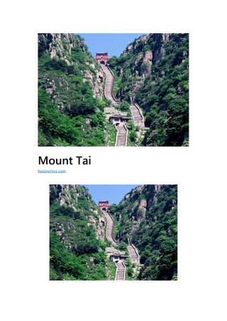
  • 2. G eographic location:Tai’an City, Shandong Province Level:AAAAA Main peak:Jade Emperor Suitable for the play season:Suitable for spring, summer and autumn Taishan, also known as Lushan, Yuzong, Yuyue, Dongyue and Taiyue, is one of the famous Wuyue in China. It is located in the central part of Shandong Province, between the three cities of Tai’an, Jinan and Zibo, with a total area of 24,200 hectares. The main peak, Yuhuangding, is 1,545 meters above sea level. It is magnificent and majestic. It is known as the “first of the Five Sacred Mountains”, “the longest of the Five Sacred Mountains”, “the honor of the Five Sacred Mountains” and “the first mountain in the world”. It is the world’s natural and cultural heritage, the World Geopark, the national AAAAA-level tourist scenic spot, the national-level scenic spot, the national key cultural relics protection unit, and the national civilized scenic tourist area. Taishan is regarded by the ancients as a paradise for “direct access to the emperor”. It has become the worship of the people, and the emperor’s sacrifice to the mountain of God, there is the saying that “Taishan An, all the seas are safe”. Since the beginning of Emperor Qin Shihuang to the Qing Dynasty, there have been 13 generations of emperors who have been introduced to Taishan to seal the Zen or sacrifices. In addition, there are 24 generations of emperors who have sent officials to worship 72 times. There are more than 20 ancient buildings on the mountain of Taishan Mountain, and more than 2,200 stone tablets. Taoism and Buddhism regard Taishan as the “Xiangshan Buddhism” and deify the Taishan
  • 3. Mountain. A large number of temple temples have been built in Taishan. Taishan is a symbol of the Chinese nation, a microcosm of the oriental culture, a place for the “Heaven and Man” idea, and a home for the Chinese national spirit. Geographical environment Location horizon Taishan runs through the central part of Shandong Province, in the territory of Tai’an City. It is between Tai’an City and Jinan City. It was called “Lushan” and “Zhuzong” in ancient times. It was renamed “Taishan” in the Spring and Autumn Period. In front of Mount Tai, the hometown of Confucius is Qufu, and he is backed by Jinan. Mount Taishan is located in the east of the North China Plain. It is above the Qilu Plain, with the sea to the east, the Yellow River to the west, and the waters of Wen, Yu and Huai in the south. It is about 200 kilometers long from east to west and about 50 kilometers wide from north to south. , the branch vein, the remaining veins involved in the surrounding ten counties, the disk area of 426 square kilometers, the main peak Yuhuangding elevation of 1545 meters.
  • 4. Geological features The geological structure of Mount Tai is very complicated, mainly based on faults, and its structural features are fault block uplift. It has both the structure formed by the Precambrian and the structure developed by the Mesozoic and Cenozoic. The Precambrian geological tectonic development of Mount Tai is characterized by multi-period folds, faults and ductile shear zones. They are superimposed on each other and form an extremely complex structural appearance. The study of their genetic mechanism is one of the important contents of Precambrian geological research. In addition, the rare “barrel structure” developed at home and abroad in the Middle Proterozoic diabase diagenetic rock has high scientific value. From the perspective of regional structure, the Pacific plate has a strong subduction of the Eurasian plate in the near-East direction, which makes the Taishan area under the north-south extension, and the northeast-eastern Taiqian fault has a strong skewing activity, and the Taishan is greatly uplifted, resulting in the Taishan The neotectonic movements are very common and strong, and they play a dominant role in controlling the formation and geomorphology of Mount Tai. The gravity sliding structure formed by the Lower Paleozoic and Precambrian crystalline basement unconformity around Taishan is also closely related to the neotectonic movement.
  • 5. Topography Taishan is the highest mountain in Shandong’s hills. The stratum is the typical basement and caprock structure of the North China Platform. The southern part has a large increase and the cover is weathered, revealing a large basement—the Taishan complex, the Taishan Boundary Taishan Group. With an absolute age of 2.5 billion years, it is one of the oldest strata in China. The northern part of the rise is small, and the caprock preserves the Paleozoic strata developed on the typical North China platform. The Taishan landform is divided into four types: the alluvial platform, the denuded hills, the tectonic low mountains and the low mountains in the erosive structure. In the spatial image, it is low and high, causing the layers of ridges and volcanic stagnation. A landscape of a combination of multiple terrain groups. Neotectonics and the formation of Mount Tai The formation of Mount Tai experienced a long and complicated evolution process, which can be divided into the formation stage of Gutai Mountain, the stage of sea-land evolution and the stage of formation of Mount Tai.
  • 6. During the Archean period, Mount Tai was once part of the huge sedimentation belt or trough of Luxi, and accumulated thick muddy sand and basic volcanic material. Later, after the Taishan movement, the folds and ridges became a huge mountain system, and a series of faults, magmatism and metamorphism occurred simultaneously. A Taishan complex composed of various metamorphic complexes and magmatic rocks has been formed. Gutai Mountain, which stands on the sea level, has been flattened by long-term weathering and erosion. In the early Paleozoic era, the vast area of North China fell sharply, and the Gutai Mountain also sank below sea level. On the basement erosion surface of the ancient metamorphic complex, a set of nearly two-kilometer-long Cambrian- Ordovician limestone was deposited. . At the end of the Middle Ordovician, under the influence of the Caledonian movement, the North China region as a whole rose to land and experienced a relatively long-term sedimentary discontinuity. At the beginning of the Carboniferous, there was a brief ups and downs. The Taishan area was in the time-sea and sea environment. On the erosion surface of the Middle Ordovician, the intercontinental coal-rock system of the Middle and Late Carboniferous was deposited. Later, the Taishan area continued to rise and entered the development stage of the mainland. During the Mesozoic period, a NEE-oriented Taiqian fault was formed in the southern foot of Yushan, and the original Gutai Mountain in the north plate of the fault was continuously raised and uplifted and subjected to weathering and erosion. In the Cenozoic era, Mount Tai continued to be greatly tilted and uplifted. At the height of the mountain, all the sedimentary caprocks that were originally covered on the ancient metamorphic complex were eroded, and the metamorphic complex formed more than 2 billion years ago was re- opened. Exposed to the surface. Until the middle of the new generation, about 30 million years ago, the overall turn of Taishan was basically formed. Later, under the constant erosion cutting and weathering and erosion of various external geological processes, it gradually became a majestic landscape of Mount Tai. The NEE formed in the southern foot of the Taishan Mountains in the Mesozoic Eruption, tending to the southeast, with a dip angle of 800-850 degrees. The northern plate is the Taishan complex of the Taishan,
  • 7. and the southern plate is the Cambrian limestone and shale. In the form of faults, the fault bandwidth is several tens of meters to hundreds of meters. It consists of multiple faults and multiple fragments. The strike extends over a hundred kilometers and has the characteristics of large drop, long extension, complex mechanical properties and multi-phase activities. Since the Jurassic formation, its activities have continued to modern times, so that the Taishan Mountain in the north plate has been continuously uplifted and subjected to weathering and erosion. The Tailai Basin in the south plate has been continuously declined to accept sedimentation. It directly controls the formation and evolution of the Taishan and Tailai basins, and is the natural boundary between the two, which plays a decisive role in controlling the formation of Mount Tai. As a young fault block mountain system, Mount Tai is the result of the continuous uplifting and neotectonic movement of the northern plate of the Taiqian fault. Eroded landscape Under the influence of the neotectonic movement, Taishan’s erosion and cutting effect is very strong, and various types of erosive landforms are widely developed. Since the uplift of the southern slope of Taishan is much larger than that of the northern slope, the erosion intensity of the southern slope is relatively strong, and the eroded landform is relatively developed.
  • 8. According to the morphology and genesis, the developed erosive landforms can be divided into the following five types: Eroded structure Zhongshan: concentrated in the vicinity of the main peak of Mount Taishan, Yuhuangding and the old platform, Huangshiya and Huangyashan, the altitude is about 1000-1500 meters, the lithology of the mountain is mainly metamorphic rocks and granite, which is the highest in the region. The mountain with the highest lift and the strongest erosion and cutting. The peaks and valleys are deep and the terrain is steep. The maximum depth of cutting is 500-800 meters. The valley slope is steep and there are many drops. The gravity collapse is remarkable. The cliffs and inverted stone piles formed after the collapse are everywhere. Erosion structure low mountains: distributed in the area of Aofeng, Zhongtianmen and Jiandingshan, with an altitude of 700-100 meters and a relative height of more than 200 meters. The lithology of the mountain is mainly metamorphic rocks and granites and diorite. . The erosion cutting strength is slightly weaker than the main peak. However, the terrain is still very steep, and the deep trench canyon, the apex hill, the serrated ridge, and the steep cliff are visible. Corrosion and erosion structure Low mountain: It is distributed in the area from Jiguanshan to Qingshan in the northeast of the main peak. The altitude is generally 500-700 meters, and the relative height is above 200 meters. The mountain is mainly composed of metamorphic rocks and Paleozoic Cambrian limestone. The erosion cutting intensity is medium, and the mountains are stretched. For example, the top is covered with thick layers of limestone, which often forms a “square mountain” or “table-like mountain” with steep tops, such as the hills in the Zhangxia and Shangshan mountains, sometimes due to the dissolution of limestone. It can form caves and “corrosive mountains” and other types of dissolved landforms. Erosion erosion hills: mostly distributed in the Cambrian limestone area on the northern edge of Mount Tai, with an altitude of 300-500 meters. The relative height difference is less than 200 meters. The degree of erosion cutting is relatively weak, the terrain is low and gentle, and the valleys are not developed, forming a kind of
  • 9. “piggyback mountain” with a ridged ridge, and the phenomenon of gully and cave is more common. Tin-etched hills: mainly distributed on the edge of the low mountains in the south of the mountain, from Dahe to Hushan and Huangqian, with an altitude of about 200 meters. Most of the bedrocks are metamorphic rocks and granites. The erosion intensity is very weak, mainly due to erosion and weathering. More form a soaring hills. Miniature landscape Under the influence of the neotectonic movement, Taishan not only developed various types of eroded landforms, but also formed many small or miniature landscapes. Such as Dazhigou, Dagou Lane, Yaozigou, Sanchagou canyon landforms, Baizhang Cliff, Fanzi Cliff cliff topography. Longjiao Mountain, Shantou Mountain, and the Qixia Landform of the Aofeng Peak. As well as the steep and peculiar landscapes such as the Valley of the Valley in the Pottery Pavilion, there are also many three-level miniature landforms in Mount Tai, which are strong evidence of the intermittent rise of neotectonic movements.
  • 10. Three-level plan The first level of the plane: distributed around the Humen, Hongmen, Jinshan and Huangshan highways in the southern foothills of Mount Tai. The altitude is 50-200 meters, forming a undulating hill, equivalent to the plane of the North China Lincheng period. The second level plane: distributed on the gentle ridges of Fanzi Cliff and Motianling, with an altitude of 600-800 meters, which is equivalent to the plane of the Tang County in North China. The third level plane: distributed on the top of the dome and the wide mountain top, with an altitude of 1000-1500 meters, forming a capped surface that is slightly inclined to the north, equivalent to the mid-plane of the North China Lu. Three fold valley slope On the north and south sides of the dome, the valley slope of the canyon is often seen three times. According to its changes, the canyon development process is roughly divided into three periods: the upper section of the canyon, the lower section of the canyon and the valley. In addition, the phenomenon of the turning of the stream line can also be seen in the longitudinal section of some valleys. This situation can also explain the stage of the new tectonic movement and its geomorphological development.
  • 11. Tertiary cave The small scorpion in the northern part of Mount Tai has exposed the thick layer of limestone in the Cambrian Zhangxia Formation. The dissolution in the limestone is significant, and there are many large and small caves, which are distributed at an altitude of 510 to 560 meters. Height. The grading phenomenon is very obvious. The first- class cave is located between 510 and 515 meters above sea level, the second-level cave is located at 540-545 meters above sea level, and the third-level cave is located at an altitude of 560 meters above sea level. The natural arrangement of the tertiary caves constitutes a peculiar landscape, and is an ideal example of the indirect and phased nature of the Taishan new tectonic movement.
  • 12. Tertiary terrace The third terrace of the river around Taishan is developed, in which the first and second terraces are well preserved, and the third terrace is often left in the piedmont zone by late erosion. For example, in Xiaosha River near Qingyang Village, the first terrace is about 6 meters above the riverbed, the second terrace is 20 meters above the riverbed, and the third terrace is 30 meters above the riverbed. The relative height difference of the terraces at different levels reflects the crust. The difference in the extent of the increase. Sandie Falls There are many waterfalls in the Taishan Valley, which creates a view of the Taishan Waterfall. Under the Baizhang Cliff in Heilongjiang, there are two small pools at 30 meters and 50 meters respectively, which together form a three-tiered waterfall. In the east side of the turf palace, the San Tan Die Waterfall consisting of three small drops of water has a drop of about 3 meters. The Tan Waterfall is quite unique and has the name of “Small Three Pools of the Moon”.
  • 13. Climatic conditions The climate above and below Taishan is characterized by vertical changes. At the foot of the mountain, the average temperature is -3 °C, the top of the mountain is -9 °C, the average temperature of the mountain is 26 °C in July, and the peak is 18 °C. The annual precipitation increases with height. The annual precipitation of the mountain is 1132 mm, and the mountain is only 722.6 mm. The four seasons of the mountain are distinct. The top three seasons are like spring, and the winter is like jade. That is, winter is foggy and crystal clear as jade, which is one of the important landscapes. The sand is large in spring. Taishan has a long winter, with an icing period of 150 days and a minimum temperature of -27.5 °C at the top, forming a smog and rain wonder.
  • 14. Hydrological characteristics Taishan Mountain is densely covered with rivers and rivers. The water resources are abundant. The total reserves are 3.043 billion cubic meters, including 1.497 billion cubic meters of groundwater, 1.546 billion cubic meters of surface water, and 2.608 billion cubic meters of available water. Taishan River Creek takes the Jade Emperor’s Top as the watershed. In the north, Yufu River and Dasha River are injected into the Yellow River, the Shiwen River in the east, the Fengjiazhuang River in the east, the grooming river in the south, the Xixi River, and the Wenzhou River in the west are all injected into the Dawen River. Due to the high terrain of Taishan Mountain, the river is short and short-flowing, with strong erosive force, and the river channel is controlled by faults. Therefore, there are many water falls and waterfalls. The bedrock bedrock is eroded by flowing water and is formed into a pool. It is easy to form a landscape with alternating waterfalls. The waterfalls in Mount Tai are mainly Black Dragon Pond Waterfall, Santan Die Waterfall and Yunbu Bridge Waterfall. Due to the development of fissures, Taishan has a wide distribution of fissure springs. From the dome to the foothills, the springs are vying, the mountains are high and the waters are long. There are dozens of famous springs, such as Wangmuquan, Moon Spring, Yujingquan, Longquan and Huanghua. Spring, jade pool and so on. The spring water is sweet, colorless and transparent. It contains many kinds of trace elements needed by the human body. It is a high-quality mineral water and is known as one of Taishan Sanmei (cabbage, tofu, water). In the northern part of Mount Taishan, the Middle and Upper Cambrian and Ordovician limestone rock layers are inclined to the north, and the groundwater is exposed to the top of the terrain. From Jinxiuchuan to the north, the springs are lingering and dotted. On the edge of the foothills of the northern foothills, karst water flows to the north and rushes out.
  • 15. Natural resources Plant resources Taishan belongs to the flora of North China. Due to the influence of the Yellow Sea and the Bohai Sea, it is rich in rainfall and is a transitional zone between dry and wet. Taishan plants are flourishing, with 1412 species of 645 genera and 446 species of higher plants; 446 species of lower plants; 1136 species of vascular plants, belonging to 133 families and 550 genera, including 814 species of wild plants and 322 species of cultivated plants. The vegetation of Mount Tai is divided into forests, shrubs, and irrigation from meadows and meadows, and the forest coverage rate is over 80%. There are 144 species and 989 species of seed plants, including 433 species of 72 families of woody plants, 556 species of 72 families of herbaceous plants, and 462 species of 111 families of medicinal plants. The ancient and famous trees of Mount Taishan originated from nature and have a long history. According to the “Historical Records”: “Maolin is full of mountains, and there are several high-rise trees in the surrounding area.” There are 34 tree species and more than 10,000 plants. They are closely related to the development of Taishan history and culture, and are the symbol of ancient civilization. Among them, there are Han Bai Ling Han, Hang Yin Feng Hou, Tang Yi Bao Zi, Qing Tan Chitose, Six Dynasties, Yi Pin, Wu Da Fusong, Wangrensong, Song Dynasty Ginkgo, and Centennial Wisteria, each of
  • 16. which is a witness of history, has become a precious heritage through weather and frost. Animal resources The Taishan animals are mainly representative groups of the animal geographical regions of the mountainous areas of Luzhongnan, and most of them are visible species in North China. According to the survey, there are 25 families, 20 genera and 25 species of mammals in Taishan. There are 34 families, 88 genera and 154 species and 1 subspecies in birds. There are 12 families, 7 genera and 12 species in genus, 3 families, 3 genera and 6 species in amphibians. There are 45 species, belonging to 12 families including Aphididae, Aphididae, Aphididae and Silverfish. Terrestrial vertebrates have many types, large quantities and wide distribution. There are also many terrestrial arthropods, including arachnids, insects, and polypedes. About 900 species of insects have been identified.
  • 17. Mineral resources Taishan is rich in mineral resources, such as coal, iron, rock salt, gypsum, sulfur, serpentine, medical stone, wood jade, jasper and other minerals. There are more than 40 kinds of minerals discovered and proven in Mount Tai and its surroundings. As the first energy source, the coal is rich in reserves and is distributed in three coal fields such as Feicheng, Xinwen and Ningyang around Taishan. It is one of the main coal producing areas in Shandong Province. The contact-type iron ore is distributed in the eastern foot of Taishan and its south side. Its iron-rich ore is of high quality and is the largest iron-rich mineral producing area in Shandong Province. In the Dawenkou area in the southern part of Mount Taishan, there are buried large deposits of gypsum, salt and natural sulfur deposits. The formation and distribution of Taishan mineral resources are closely related to the evolution process of Mount Tai. In the Taishan complex of Taikoo, a variety of architectural stone, as well as metamorphic minerals such as medical stone, feldspar and quartz stone, are formed. During the Paleozoic period, sedimentary minerals such as coal, bauxite and limestone were formed. The Mesozoic formed endogenous minerals such as iron-rich ore, copper, cobalt and barite. The new generation formed sedimentary minerals such as gypsum, rock salt and natural sulfur.
  • 18. Scenic spots Six major scenic spots Taishan Scenic Area includes six scenic spots, namely, secluded area, 旷 area, Austrian area, Miao area, Xiu district and Li District. Four wonders of Mount Tai The best time to visit Mount Tai is from May to November each year. You Taishan see four wonders: Taishan Sunrise, Yunhai Jade Plate, Xixia Xizhao, Yellow River Gold Belt.
  • 19. Yin and yang On the south side of Taishan Changshou Bridge, at the top of Dongbaizhang Cliff, there is a shallow white rock belt that straddles the vertical valleys on both sides of the river. It seems that a white strip is embroidered on the edge of the cliff. Because of the long-term flowing water, the surface is smooth as a mirror. The color is bright and striking. If you pass it a little carelessly, you will fall to the bottom of the cliff and fall into the valley, hence the name “Yin and Yang.” The Shiping under the bridge is a granular and granitic granitic granite in the proud mountain. The texture is hard and the resistance to weathering and erosion is relatively strong. After long-term weathering and erosion and the scouring of the stream, such a large and smooth Dashiping is formed. The so-called “yin and yang” is actually a granitic vein composed of feldspar and quartz. The surface is grayish white, with a pulse width of 1-1.2 m, extending along the southeast 130° direction, and nearly erect output in the monzonitic granite. In the middle, the boundary with the surrounding rock is very clear, the production is stable, the linear distribution, the color is bright, and it is located on the edge of the cliff of Dongbaizhang Cliff, the terrain is very dangerous. The ancients regarded this vein as the dividing line between the sun and the underworld.
  • 20. Peach blossom Peach Blossom, located in the northwest of the dome, has a funicular to the dome. The rocks exposed around the ropeway station are mainly granulated granitic granitic granites in the proud mountains. On the east side, there is a fault in the northwest to the Longjiaoshan fault, and there are associated faults on both sides of the fault. One of the associated faults cut through a hill and formed a jointed belt about 5 meters wide. The joint surface is nearly erect, and the monzonitic granite is cut into many thin plate-like blocks. Under the action of gravity, the rock blocks collapse along the erect joint surface. Finally, a large crack of several meters wide is formed between the two peaks, which is the famous peach blossom line. Color Stone Creek is not only an important production area of Taishan Kistler. According to the investigation of Taishan staff, it is believed that there is a set of surface rock system based on basic oblique amphibolite (basic volcanic rock) in Caishixi, belonging to Taishan. Rock group. The original rock is an acidic volcanic rock and an acidic volcanic tuff, which constitutes a bimodal type. Due to the strong deformation, the basic volcanic rock has been pulled into a structural patch, and its structural deformation has been cut off later, and the later veins have been cut off. In addition, there are phenomena of mylonite, and the geological phenomena such as structure and stratum are very rich.
  • 21. Pride The west of Fanzi Cliff is the proud peak. Because of the prominence, there is a tendency to compete with the main peak of Mount Tai. There are folk songs in the past: “The pride is high, the pride is high, the look is close to the Qi, and the distance is on the mountainside.” The combination of the proud peak and the fan cliff is the mountain pass. After the mountain pass, it is the green Tonglu, which is unpredictable. The north of the mountain is the pot bottle cliff and the cliff is thousands of miles. Standing on the mountain pass, watching the fan cliff in the east, such as half of the wreckage, crumbling, people are shocked, looking west and proud of the peak, like the connection with the heavens, the north of the pot bottle cliff, the cliff into the cloud. The rocks exposed in Fanzi Cliff and Aofeng Peak are all granitic granitic granitic granites in the proud mountains.
  • 22. Humanity history Historical status Wuyue is the respect of the mountains, and Mount Tai is the length of the Five Sacred Mountains. Wuyue is the general name of China’s five famous mountains, generally referred to as Dongyue Taishan (located in Shandong), Xiyue Huashan (located in Shaanxi), Nanyue Hengshan (located in Hunan), Beiyue Hengshan (located in Shanxi), and Zhongyue Mountain (located in Henan). Because of its imposing manner, Taishan has the reputation of “the best in the world”. As early as in ancient times, the Taishan area has become an important birthplace of oriental culture. The remains of the Xintai people fossils 50,000 years ago and the remains of the Wuyuan people fossils 400,000 years ago showed the early human activities in this area. The Dawenkou culture in Nanshan, Taishan, and the Longshan cultural relics in Beibei also reflect the activities of the clan tribes in the early Yellow River Basin. During the Warring States Period, Qi State built a Great Wall about 500 kilometers long along the Taishan Mountains and directly to the Yellow Sea. After entering the Qin and Han Dynasties, Taishan gradually became a symbol of the political power. The actual altitude of Mount Tai is not too high. It ranks third in Huashan and Hengshan in Wuyue. But in terms of historical politics and the status of culture, many of the country’s mountains cannot be compared to it. The ancients described “Taishan swallowing Xihua, pressing Nanheng, driving in the middle of the squad, and smashing the north to be the longest of the Five Sacred Mountains.” In ancient Chinese myths and legends, after the death of Pangu, the head turned into Mount Tai. According to the “Historical Records Collection”: “The sky is unreachable, and it is worshipped on the Mount Tai in the mountains, and it is close to the gods.” Ancient traditional culture
  • 23. believes that the East is the place where all things alternate and the beginning of spring, so Taishan has “Five Mountains.” The reputation of “the long” and “the five sacred independence”. Since ancient times, the Chinese have worshipped Mount Tai, and there is a saying that “Tai Shan An, all the seas are safe.” In the ancient dynasties, the dynasties and rituals were continually sealed in Taishan, and temples were built up and down in Mount Tai. The ancient scholars of the literati admired Mount Tai. There are more than 20 ancient buildings on the mountain of Taishan Mountain, and more than 2,200 stone tablets. Mount Tai is located in the east of the North China Plain, above the Qilu Plain, east of the vast sea of smoke, west by the long-running Yellow River, south of Wen, Shu, Huai water, and the height difference between the plain and the hills is 1,300 meters, forming a strong The contrast is visually superb and rhythmic and the sorghum momentum of “listing the mountains and small mountains”; the mountains are more than 100 kilometers long, and the plates are 426 square kilometers. The foundation is wide and stable, and the body is large and concentrated. It creates a sense of weight, and there is a great instrument of “Zhen Kunwei does not shake”. The so-called “stable as Taishan” and “heavy as Taishan” are the reflections of their natural characteristics on people’s physical and psychological. In the Six Dynasties Ren Bian, “Remarks on the Alien”, in the Qin and Han Dynasties, the folk legend Pan Gushi (the ancient god who opened the earth in ancient times and surpassed all things) was Dongyue after his death, the left arm was Nanyue, the right arm was Beiyue, and the foot was Xiyue. The head of the Pangu corpse turned to the east, and turned into Dongyue. Taishan became the first of the five sacred mountains. This is obviously a mythical story based on the “Five Elements” and “Five Morals” doctrines, reflecting the historical background of Taishan’s unique five-story.
  • 24. Cultural heritage Because the East is the source of life, a symbol of hope and auspiciousness. The ancient Chinese ancestors often regarded the majestic Dongyue as a god, and worshipped the mountain god as an object of praying for the rain, so the Taishan, which is located in the east, became the “auspicious mountain” of the place where all things are bred. “The house of the gods.” The “Tianzi” of the emperor is regarded as the symbol of national unity and power. In order to thank the Emperor of Heaven for his “dedication”, he will also go to Mount Tai to sacrifice his sacrifice. According to legend, in the ancient times, the Yellow Emperor once climbed Mount Tai, and Emperor Sui once visited Taishan. During the Shang and Zhou Dynasties, Shangwang Xiangtu built Dongdu at the foot of Taishan Mountain. Zhoutianzi built Qilu with Taishan as the boundary. Before the Qin and Han Dynasties, there were 72 generations of monarchs who came to Taishan to seal the gods. Since then, Qin Shihuang (before 219), Qin II, Han Wudi (first 110 years, the first 109 years, the first 106 years, the first 104 years, the first 103 years, the first 98 years, the first 93 years, the first 89 years), the Hanguang Emperor (56 years), the Hanzhang Emperor (85 years), Han Emperor (124 years), Emperor Wendi (595), Tang Gaozong (666), Wu Zetian, Tang Xuanzong (725), Song Zhenzong (1008), Qing Emperor Kangxi, Qianlong and other ancient emperors received the Taishan Fengchan Festival , carved stone records. From the Qin and Han dynasties to the Ming and Qing Dynasties, the emperors of the past generations went to Taishan to seal the Zen 27 times The emperors of the past used the power of Mount Tai to consolidate their rule, and the sacred status of Mount Tai was carried to an extent that could not be added.
  • 25. The emperor’s meditation activities and majestic and magnificent scenery, cultural celebrities of all ages went to Taishan to write poetry and essays, leaving thousands of poetry and engravings. Such as Confucius’s “Qiu Ling Ge”, Sima Xiangru’s “Fang Chan Book”, Cao Zhi’s “Fei Long Pian”, Li Bai’s “Tai Shan Biao”, Du Fu’s “Wang Yue” and other poems, became China’s famous world; The Song Dynasty murals of the Song Dynasties and the Song Dynasty colored Luohan statues of Lingyan Temple are rare treasures; the stone carvings and monuments of Mount Tai, the great achievements of Chinese calligraphy art, the real grasses and the various bodies, the Yan Liu Ou Zhao each sent to the present, is China The Expo Hall of Calligraphy and Stone Carving in the Past Dynasties. Taishan’s cultural heritage is extremely rich. There are 97 ancient sites and 22 ancient buildings. It provides important material information for studying the history of ancient Chinese architecture. Taishan is one of the birthplaces of ancient culture in the Yellow River Basin. A long time ago, Taishan was developed by humans. The Dawenkou culture in the southern foothills of Mount Tai and the Longshan cultural remains in Beibei are evidence. There are still the remains of the Xintai people fossils 50,000 years ago and the remains of the Wuyuan people fossils 400,000 years ago. During the Warring States Period, along the Taishan Mountains, the Great Wall, which was about 500 kilometers long, was built directly to the Yellow Sea. The attractions related to the activities of Taishan and Confucius include Confucius Denglaifang Square, Wangwushengjifang, Confucius Xiaotianxia, Confucius Temple, Zhanlutai and Menghugou. Shenshan and the cultural treasure house Taishan have the reputation of “the first of the Five Sacred Mountains” and the “Five Sacred Mountains”. It is a symbol of the government and a sacred mountain. Taishan religion has a long history, and Buddhism was introduced to Mount Tai in the middle of the 4th century. After Zhao Yongning’s second year (351 years), Gao Songlang first established Langgong Temple and Lingyan Temple to Taishan Yuyin. During the Wei, Jin and Southern and Northern Dynasties, the larger temples in Taishan included Gushan Yuhuang Temple, Shenbao Temple and Puzhao Temple. The famous Taishan Jingshi is the Buddhist classic “The Diamond Sutra” carved by the Northern Qi people. During the Tang
  • 26. and Song Dynasties, Lingyan Temple was extremely prosperous. Tang Jixiang Li Jizhen countered the Taishan Lingyan Temple as one of the “four musts” in the world. As early as in the Warring States Period, Taishan Taoism had the retreat of the alchemist in the Yinyin Cave. After the Qin and Han Dynasties, there were many temples, including Wangmuchi (Group Wang), Laojuntang, Doum Palace (Longquanguan), Bixiayu, Houshiwu. Temple, Yuanshi Tianzun Temple, etc. Among them, Wangmuchi was the earliest. It was founded in the 25th year of the Eastern Han Dynasty (220 years); it was the most affected by Bixia. Mount Tai is the birthplace of the mythical legend of the Queen Mother. As early as the Wei and Jin Dynasties, there was a Taoist temple view. Wangmuchi is located at the east of Huanshan Road in the south of Taishan Mountain. It was called “Qianyu”, also known as “Yaochi”. The Three Kingdoms Wei Caozhi has the verse of “East King Mother”, and Tang Libai has the slogan of “Ding Yin Wang Wangchi”.
  • 27. Travel Information Traffic Taishan is closely connected with the mountain city of Tai’an City. Tai’an City is located in the south of Taishan Mountain. Taishan is in the north of Tai’an City. On a sunny day, the peak of Mount Taishan is clearly visible. Taishan officially sold tickets for mountaineering imports in four places: Red Gate Palace into the mountain pass, Tianwai Village (Tiandi Square) into the mountain pass, Taohuayu into the mountain pass, Tianchanfeng into the mountain pass. Taian is an hour’s drive from Jinan Yaoqiang International Airport. Taian is close to Mount Tai, and the back of the mountain is the provincial capital of Jinan. Tai’an has Beijing-Taiwan Expressway, Beijing-Shanghai Expressway, Beijing-Shanghai Railway and Beijing- Shanghai high-speed rail. Take the high-speed train, go to Beijing less than 2 hours, and go to Shanghai for about 3 hours. 