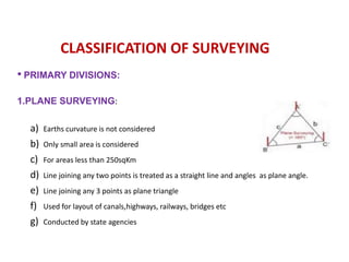
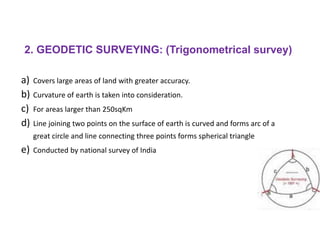
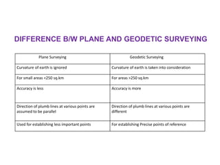
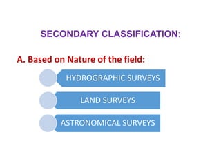
SURVEYING
SURVEYING
•Art of determining relative position of objects on
the earth surface or above or beneath the earth
surface.
•Relative positions are determined by taking
horizontal and vertical distances.
•Horizontal and vertical angles accurately using
surveying equipments.
•After taking measurements computations are
done and maps are prepared.
•Different methods and instruments are used
to facilitate the work of surveying.
•The measured distances and directions are
represented through a plan or map to
suitable scale.
OBJECTIVES OF SURVEYING
•Take measurements to determine relative position of
existing features on or near the ground.
•To layout or mark positions of proposed structure on
ground.
•Data obtained from surveying are used to prepare plan or
map showing ground features.
•Setting out of engineering work like buildings, roads,
railway tracks, bridges and dams involves surveying.
•To determine areas, volume and other related quantities.
• The primary object of any survey is the
preparation of plan or map.
• Plan – Projection of a ground and the features
PRINCIPLES OF SURVEYING
•Work from whole to part
•To fix position of new stations by atleast two
independent points of reference
According to this principle, it is always desirable
to carryout survey work from whole to part. This
means, when an area is to be surveyed, first a
system of control points is to be established
covering the whole area with very high precision.
Then minor details are located by less precise
methods.
1.Working from whole to part
The idea of working this way is to prevent the accumulation of errors and to control and
localize minor errors which, otherwise, would expand to greater magnitudes if the reverse
process is followed, thus making the work uncontrolled at the end.
2. Location of new station from two reference points
•Let A and B are the reference points and C is a new
station
1. By measuring distance AC and BC
• Used in Chain surveying
2. By dropping perpendicular CD from C
• Measure AD and CD
• Using set square find AC
• Called offsetting and used for locating details
3. By measuring distance BC and < ABC
• C obtained by solution of triangles
• Used in traversing
4. By measuring distance AC and < ABC
•Swing arc of radius AC from A and < from B
•Meeting point is C
•Used in traversing
5. By measuring <ABC and <BAC
• Used in triangulation
• PRIMARY DIVISIONS:
1.PLANE SURVEYING:
a) Earths curvature is not considered
b) Only small area is considered
c) For areas less than 250sqKm
d) Line joining any two points is treated as a straight line and angles as plane angle.
e) Line joining any 3 points as plane triangle
f) Used for layout of canals,highways, railways, bridges etc
g) Conducted by state agencies
CLASSIFICATION OF SURVEYING
2. GEODETIC SURVEYING: (Trigonometrical survey)
a) Covers large areas of land with greater accuracy.
b) Curvature of earth is taken into consideration.
c) For areas larger than 250sqKm
d) Line joining two points on the surface of earth is curved and forms arc of a
great circle and line connecting three points forms spherical triangle
e) Conducted by national survey of India
DIFFERENCE B/W PLANE AND GEODETIC SURVEYING
Plane Surveying Geodetic Surveying
Curvature of earth is ignored Curvature of earth is taken into consideration
For small areas <250 sq.km For areas >250 sq.km
Accuracy is less Accuracy is more
Direction of plumb lines at various points are
assumed to be parallel
Direction of plumb lines at various points are
different
Used for establishing less important points For establishing Precise points of reference
SECONDARY CLASSIFICATION:
A. Based on Nature of the field:
HYDROGRAPHIC SURVEYS
LAND SURVEYS
ASTRONOMICAL SURVEYS
1. HYDROGRAPHICAL SURVEY
•Conducted on or near water surfaces like lake, rivers, harbours etc
•Marine surveys are special type of hydrographical surveys
•Consist of locating shore lines, estimation of water flow and
determination of profiles beneath water surface
•Marine surveys are special type of hydrographical surveys
2. Land surveys
•To determine boundaries and areas of land
•1. Topographic surveys- Topographic features Eg: Hills,
Valleys etc.
•2. City surveys-Within city limits for urban planning
•3. Engineering surveys- For design and planning of
structures, roads etc
•4.Cadastral surveys-Fix boundaries of private owners
3. ASTRONOMICAL SURVEYS
•To determine latitudes , longitudes , azimuths
for various places on earth by observing
heavenly bodies
•Absolute location of points can be obtained
B. Based on objective of survey:
i) Geological survey: systematic investigation of the geology beneath
a given piece of ground for the purpose of creating a geological map or
model.
ii) Mine survey: involved in the accurate measurement and
recording of mine workings
iii) Military survey: establishing strategic points for offense and
defense
iv) Archeological survey: unearthing hidden places and monuments
v) Control Survey:Establish location of horizontal and vertical
positions of control points using geodetic surveying

BCE - MOD 2 - SURVEYING - Copy.pptx

  • 1.
  • 2.
    SURVEYING •Art of determiningrelative position of objects on the earth surface or above or beneath the earth surface. •Relative positions are determined by taking horizontal and vertical distances. •Horizontal and vertical angles accurately using surveying equipments. •After taking measurements computations are done and maps are prepared.
  • 3.
    •Different methods andinstruments are used to facilitate the work of surveying. •The measured distances and directions are represented through a plan or map to suitable scale.
  • 4.
    OBJECTIVES OF SURVEYING •Takemeasurements to determine relative position of existing features on or near the ground. •To layout or mark positions of proposed structure on ground. •Data obtained from surveying are used to prepare plan or map showing ground features. •Setting out of engineering work like buildings, roads, railway tracks, bridges and dams involves surveying. •To determine areas, volume and other related quantities.
  • 5.
    • The primaryobject of any survey is the preparation of plan or map. • Plan – Projection of a ground and the features
  • 6.
    PRINCIPLES OF SURVEYING •Workfrom whole to part •To fix position of new stations by atleast two independent points of reference
  • 7.
    According to thisprinciple, it is always desirable to carryout survey work from whole to part. This means, when an area is to be surveyed, first a system of control points is to be established covering the whole area with very high precision. Then minor details are located by less precise methods. 1.Working from whole to part The idea of working this way is to prevent the accumulation of errors and to control and localize minor errors which, otherwise, would expand to greater magnitudes if the reverse process is followed, thus making the work uncontrolled at the end.
  • 8.
    2. Location ofnew station from two reference points •Let A and B are the reference points and C is a new station 1. By measuring distance AC and BC • Used in Chain surveying
  • 9.
    2. By droppingperpendicular CD from C • Measure AD and CD • Using set square find AC • Called offsetting and used for locating details
  • 10.
    3. By measuringdistance BC and < ABC • C obtained by solution of triangles • Used in traversing
  • 11.
    4. By measuringdistance AC and < ABC •Swing arc of radius AC from A and < from B •Meeting point is C •Used in traversing
  • 12.
    5. By measuring<ABC and <BAC • Used in triangulation
  • 13.
    • PRIMARY DIVISIONS: 1.PLANESURVEYING: a) Earths curvature is not considered b) Only small area is considered c) For areas less than 250sqKm d) Line joining any two points is treated as a straight line and angles as plane angle. e) Line joining any 3 points as plane triangle f) Used for layout of canals,highways, railways, bridges etc g) Conducted by state agencies CLASSIFICATION OF SURVEYING
  • 14.
    2. GEODETIC SURVEYING:(Trigonometrical survey) a) Covers large areas of land with greater accuracy. b) Curvature of earth is taken into consideration. c) For areas larger than 250sqKm d) Line joining two points on the surface of earth is curved and forms arc of a great circle and line connecting three points forms spherical triangle e) Conducted by national survey of India
  • 15.
    DIFFERENCE B/W PLANEAND GEODETIC SURVEYING Plane Surveying Geodetic Surveying Curvature of earth is ignored Curvature of earth is taken into consideration For small areas <250 sq.km For areas >250 sq.km Accuracy is less Accuracy is more Direction of plumb lines at various points are assumed to be parallel Direction of plumb lines at various points are different Used for establishing less important points For establishing Precise points of reference
  • 16.
    SECONDARY CLASSIFICATION: A. Basedon Nature of the field: HYDROGRAPHIC SURVEYS LAND SURVEYS ASTRONOMICAL SURVEYS
  • 17.
    1. HYDROGRAPHICAL SURVEY •Conductedon or near water surfaces like lake, rivers, harbours etc •Marine surveys are special type of hydrographical surveys •Consist of locating shore lines, estimation of water flow and determination of profiles beneath water surface •Marine surveys are special type of hydrographical surveys
  • 18.
    2. Land surveys •Todetermine boundaries and areas of land •1. Topographic surveys- Topographic features Eg: Hills, Valleys etc. •2. City surveys-Within city limits for urban planning •3. Engineering surveys- For design and planning of structures, roads etc •4.Cadastral surveys-Fix boundaries of private owners
  • 19.
    3. ASTRONOMICAL SURVEYS •Todetermine latitudes , longitudes , azimuths for various places on earth by observing heavenly bodies •Absolute location of points can be obtained
  • 20.
    B. Based onobjective of survey: i) Geological survey: systematic investigation of the geology beneath a given piece of ground for the purpose of creating a geological map or model. ii) Mine survey: involved in the accurate measurement and recording of mine workings iii) Military survey: establishing strategic points for offense and defense iv) Archeological survey: unearthing hidden places and monuments v) Control Survey:Establish location of horizontal and vertical positions of control points using geodetic surveying