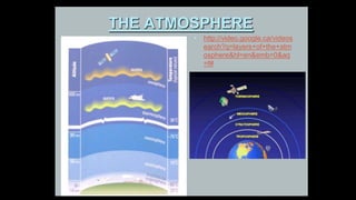
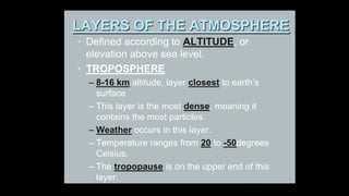
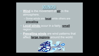
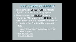
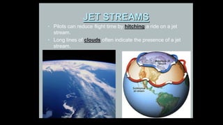
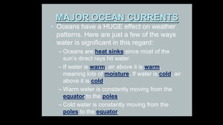
Weather Dynamics
SOME GENERAL TERMS
• WEATHER DYNAMICS is the study of
how water and air cause weather
patterns.
• WEATHER
– The short-range forecast; daily conditions.
– Ex: temperature, precipitation, wind,
humidity, UV
• CLIMATE
– Long-term seasonal trends averaged from
annual data
– Ex: In the Atlantic Canada Climate
region, winters are cold and
summers are Warm
THE ATMOSPHERE
• http://video.google.ca/videos
earch?q=layers+of+the+atm
osphere&hl=en&emb=0&aq
=f#
What is the Atmosphere?
DEFINITION:
• The blanket of air and water vapour that
surrounds the Earth.
• If the earth were an ONION, the atmosphere
would be like the ONION PEEL.
• It is about 500 km thick, containing 78% N ,
21% O , and some trace elements (ex: CO2,
H2O, Ar).
LAYERS OF THE ATMOSPHERE
• Defined according to ALTITUDE, or
elevation above sea level.
• TROPOSPHERE
– 8-16 km altitude, layer closest to earth’s
surface
– This layer is the most dense, meaning it
contains the most particles.
– Weather occurs in this layer.
– Temperature ranges from 20 to -50degrees
Celsius.
– The tropopause is on the upper end of this
layer.
ATMOSPHERIC PRESSURE
• Defined as the pressure that air particles
exert as gravity pulls them toward the
centre of the earth
• Air pressure is greatest at sea level where
air is most dense (i.e., thick)
• Air pressure decreases with altitude.
– Thus, if you climb a mountain, the weight of
the air above you is less, and the pressure is
less.
WINDS
• Wind is the movement of air in the
atmosphere.
– Some winds are local while others are
prevailing.
• Local winds occur in a fairly small
region.
• Prevailing winds are wind patterns that
affect large regions around the world.
PREVAILING WINDS
• In the early 1800s, SAILORS discovered
that, in certain areas, the winds blow in the
same direction all of the time.
THE CORIOLIS EFFECT
• The change of DIRECTIONof a moving
object in a constantly rotating system.
• The rotation of the EARTH deflects
moving air AND water to the RIGHT of its
initial direction in the Northern Hemisphere
(opposite in the Southern Hemisphere).
– Note:
• This direction of deflection is from the viewpoint of the
starting position of WHAT IS BEING DEFLECTED (ex:
plane, wind, etc.).
– FIGURE 2 - pg. 517
– FIGURE 1 - pg. 525
THE CORIOLIS EFFECT
Prevailing Winds in the Northern Hemisphere
• Prevailing Winds help distribute energy and
moisture around the globe.
• TYPES IN NORTHERN HEMISPHERE
– Polar Easterlies
• Cold easterly winds blow from the poles to 60 degrees.
– Mid-Latitude Westerlies
• Warm, moist winds blow from the west
• NEWFOUNDLAND is affected by these.
– North East Trade Winds
• Winds that blow toward the equator
JET STREAMS
• Fast moving riversof air that race across the high
altitude sky, sometimes at speeds as high as 400
km/h.
• Jet streams occur about 7000 m up in the upper
regions of the troposphere.
• They consist mostly of westerly winds, and are
caused by strong differences in pressure and
temperature.
• Air at the equator is thickerand moves from high to
low pressure areas (i.e., N or S of the equator).
• Jet streams can be thousands of miles long,
hundreds of miles wide, but only a mile or so deep.
JET STREAMS
• Pilots can reduce flight time by hitching a ride on a jet
stream.
• Long lines of clouds often indicate the presence of a jet
stream.
MAJOR OCEAN CURRENTS
• Oceans have a HUGE effect on weather
patterns. Here are just a few of the ways
water is significant in this regard:
– Oceans are heat sinks since most of the
sun’s direct rays hit water.
– If water is warm, air above it is warm,
meaning lots of moisture. If water is cold, air
above it is cold.
– Warm water is constantly moving from the
equator to the poles.
– Cold water is constantly moving from the
poles to the equator.
MAJOR OCEAN CURRENTS
• Which ones influence NEWFOUNDLAND
weather? __________________________
WHAT CAUSES OCEAN CURRENTS?
• Convection currents
• Winds across oceans
• Earth’s rotation
• Shape of continents
• Heat capacity of Water
• Amount of salt in oceans

Weather dynamics

  • 1.
  • 2.
    SOME GENERAL TERMS •WEATHER DYNAMICS is the study of how water and air cause weather patterns. • WEATHER – The short-range forecast; daily conditions. – Ex: temperature, precipitation, wind, humidity, UV • CLIMATE – Long-term seasonal trends averaged from annual data – Ex: In the Atlantic Canada Climate region, winters are cold and summers are Warm
  • 3.
  • 4.
    What is theAtmosphere? DEFINITION: • The blanket of air and water vapour that surrounds the Earth. • If the earth were an ONION, the atmosphere would be like the ONION PEEL. • It is about 500 km thick, containing 78% N , 21% O , and some trace elements (ex: CO2, H2O, Ar).
  • 5.
    LAYERS OF THEATMOSPHERE • Defined according to ALTITUDE, or elevation above sea level. • TROPOSPHERE – 8-16 km altitude, layer closest to earth’s surface – This layer is the most dense, meaning it contains the most particles. – Weather occurs in this layer. – Temperature ranges from 20 to -50degrees Celsius. – The tropopause is on the upper end of this layer.
  • 6.
    ATMOSPHERIC PRESSURE • Definedas the pressure that air particles exert as gravity pulls them toward the centre of the earth • Air pressure is greatest at sea level where air is most dense (i.e., thick) • Air pressure decreases with altitude. – Thus, if you climb a mountain, the weight of the air above you is less, and the pressure is less.
  • 7.
    WINDS • Wind isthe movement of air in the atmosphere. – Some winds are local while others are prevailing. • Local winds occur in a fairly small region. • Prevailing winds are wind patterns that affect large regions around the world.
  • 8.
    PREVAILING WINDS • Inthe early 1800s, SAILORS discovered that, in certain areas, the winds blow in the same direction all of the time.
  • 9.
    THE CORIOLIS EFFECT •The change of DIRECTIONof a moving object in a constantly rotating system. • The rotation of the EARTH deflects moving air AND water to the RIGHT of its initial direction in the Northern Hemisphere (opposite in the Southern Hemisphere). – Note: • This direction of deflection is from the viewpoint of the starting position of WHAT IS BEING DEFLECTED (ex: plane, wind, etc.). – FIGURE 2 - pg. 517 – FIGURE 1 - pg. 525
  • 10.
  • 11.
    Prevailing Winds inthe Northern Hemisphere • Prevailing Winds help distribute energy and moisture around the globe. • TYPES IN NORTHERN HEMISPHERE – Polar Easterlies • Cold easterly winds blow from the poles to 60 degrees. – Mid-Latitude Westerlies • Warm, moist winds blow from the west • NEWFOUNDLAND is affected by these. – North East Trade Winds • Winds that blow toward the equator
  • 12.
    JET STREAMS • Fastmoving riversof air that race across the high altitude sky, sometimes at speeds as high as 400 km/h. • Jet streams occur about 7000 m up in the upper regions of the troposphere. • They consist mostly of westerly winds, and are caused by strong differences in pressure and temperature. • Air at the equator is thickerand moves from high to low pressure areas (i.e., N or S of the equator). • Jet streams can be thousands of miles long, hundreds of miles wide, but only a mile or so deep.
  • 13.
    JET STREAMS • Pilotscan reduce flight time by hitching a ride on a jet stream. • Long lines of clouds often indicate the presence of a jet stream.
  • 14.
    MAJOR OCEAN CURRENTS •Oceans have a HUGE effect on weather patterns. Here are just a few of the ways water is significant in this regard: – Oceans are heat sinks since most of the sun’s direct rays hit water. – If water is warm, air above it is warm, meaning lots of moisture. If water is cold, air above it is cold. – Warm water is constantly moving from the equator to the poles. – Cold water is constantly moving from the poles to the equator.
  • 15.
    MAJOR OCEAN CURRENTS •Which ones influence NEWFOUNDLAND weather? __________________________
  • 16.
    WHAT CAUSES OCEANCURRENTS? • Convection currents • Winds across oceans • Earth’s rotation • Shape of continents • Heat capacity of Water • Amount of salt in oceans