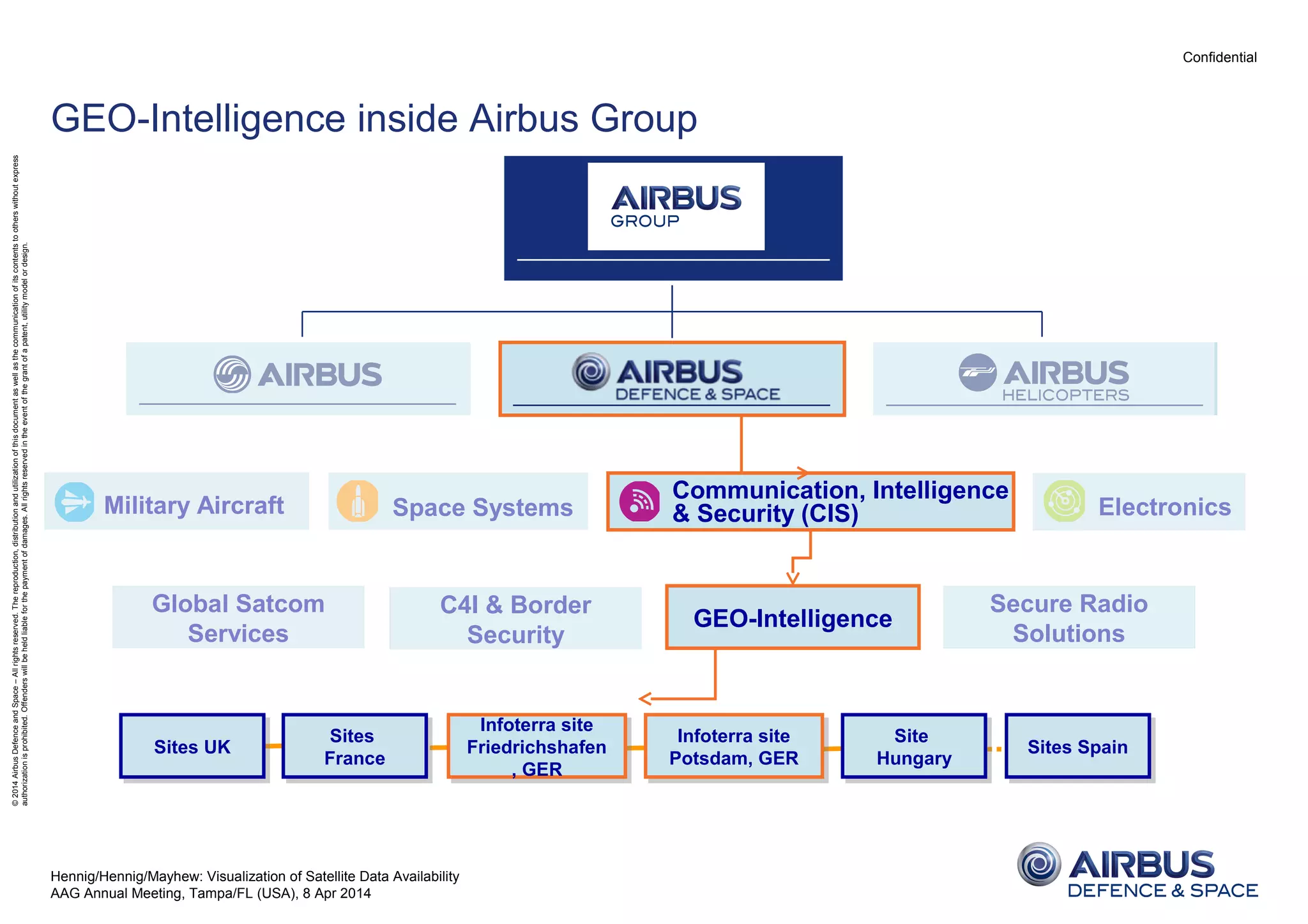
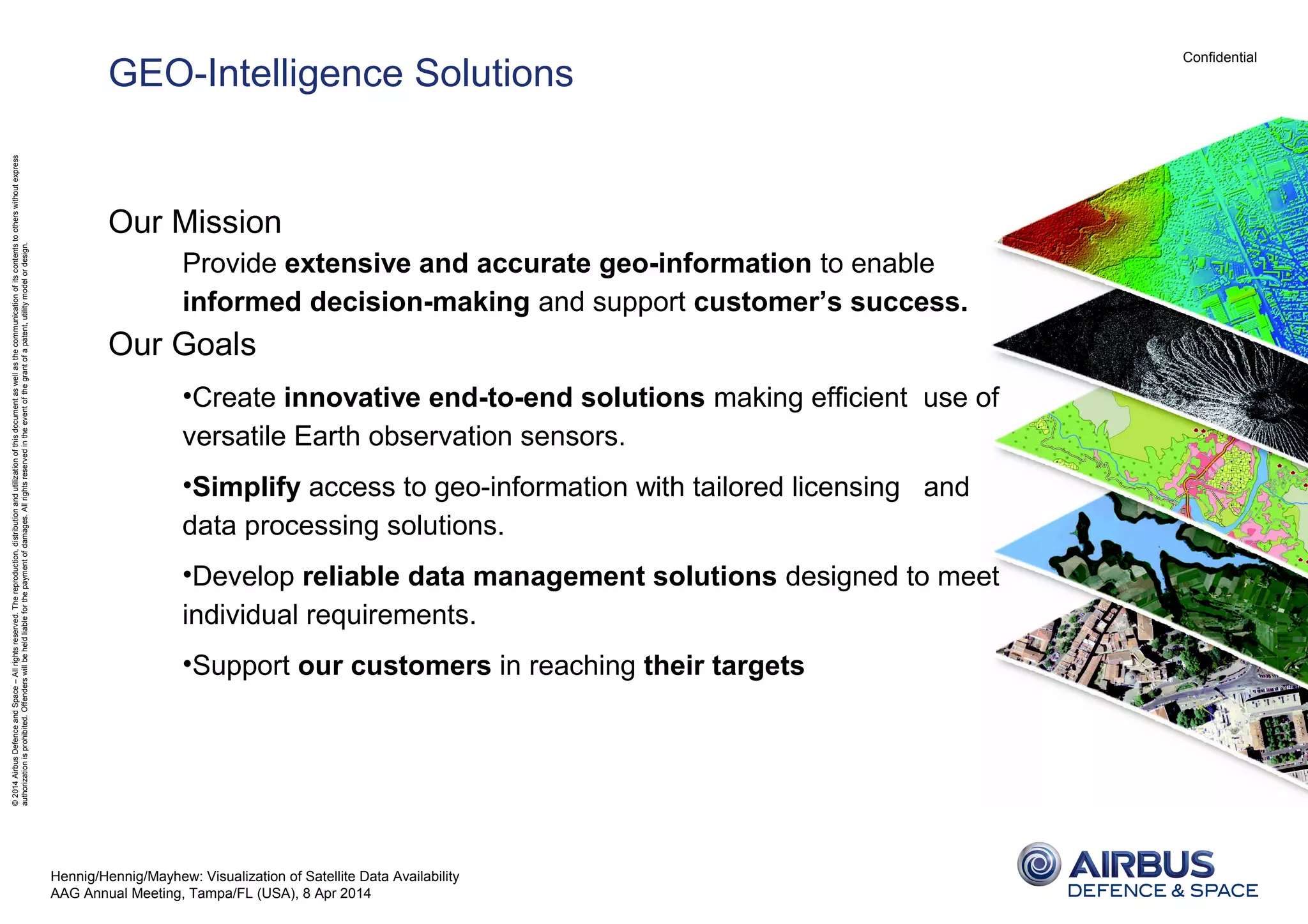
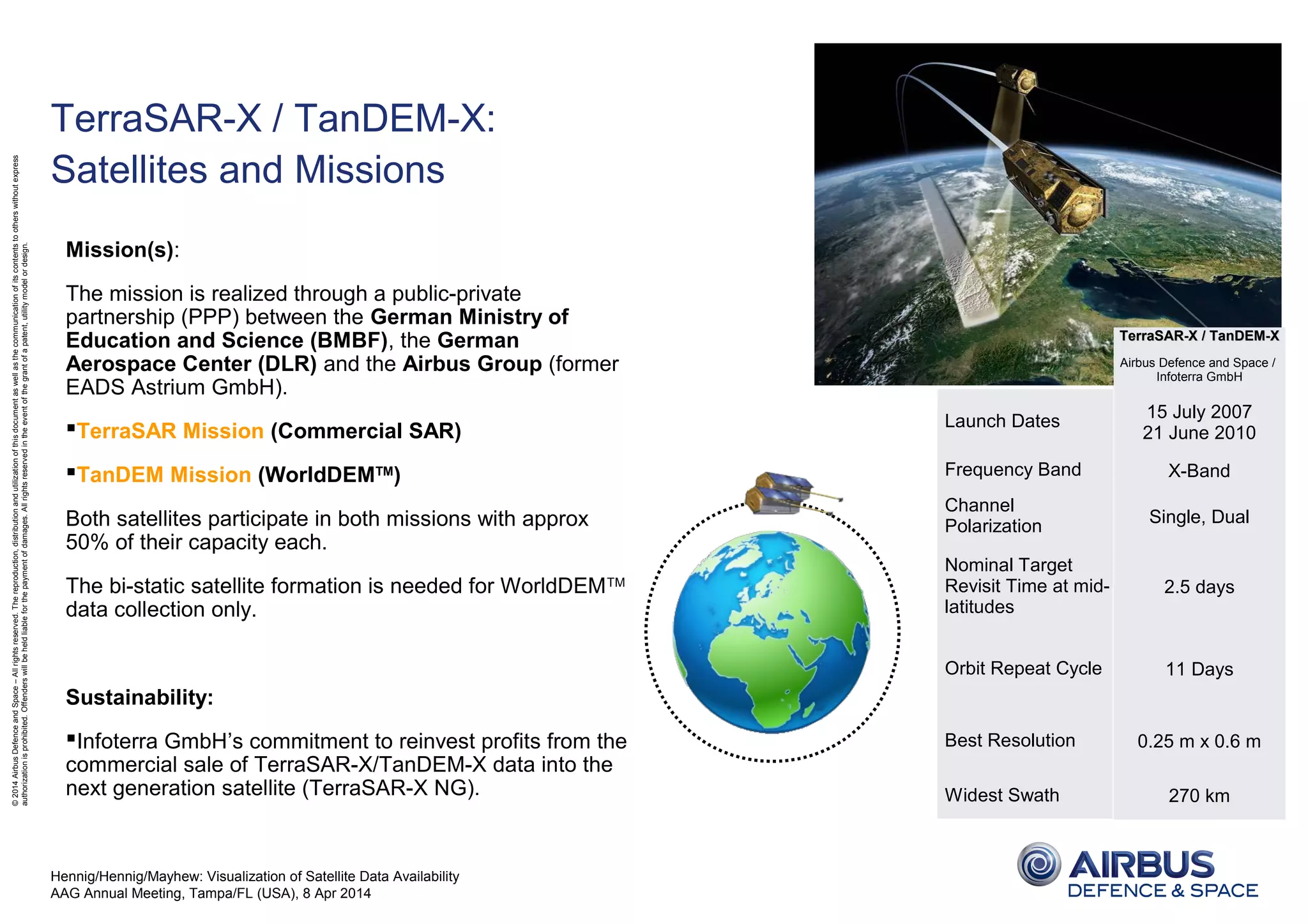
©2014AirbusDefenceandSpace–Allrightsreserved.Thereproduction,distributionandutilizationofthisdocumentaswellasthecommunicationofitscontentstootherswithoutexpress
authorizationisprohibited.Offenderswillbeheldliableforthepaymentofdamages.Allrightsreservedintheeventofthegrantofapatent,utilitymodelordesign.
Visualization of Satellite Data Availability
TerraSAR-X and TanDEM-X Running Against Time
Benjamin D. Hennig, University of Oxford, United Kingdom
Simon D. Hennig, Airbus Defence and Space, Friedrichshafen, Germany
Ben Mayhew, Airbus Defence and Space, Friedrichshafen, Germany
Confidential
©2014AirbusDefenceandSpace–Allrightsreserved.Thereproduction,distributionandutilizationofthisdocumentaswellasthecommunicationofitscontentstootherswithoutexpress
authorizationisprohibited.Offenderswillbeheldliableforthepaymentofdamages.Allrightsreservedintheeventofthegrantofapatent,utilitymodelordesign.
Airbus Defence and Space: A division of the Airbus Group
One Company
One Brand
Four Business Segments
One Parent Company
Three Brands
Multiple Business Segments
Being strong together – 3 turn into 1
Hennig/Hennig/Mayhew: Visualization of Satellite Data Availability
AAG Annual Meeting, Tampa/FL (USA), 8 Apr 2014
Confidential
©2014AirbusDefenceandSpace–Allrightsreserved.Thereproduction,distributionandutilizationofthisdocumentaswellasthecommunicationofitscontentstootherswithoutexpress
authorizationisprohibited.Offenderswillbeheldliableforthepaymentofdamages.Allrightsreservedintheeventofthegrantofapatent,utilitymodelordesign.
GEO-Intelligence inside Airbus Group
Communication, Intelligence
& Security (CIS)Military Aircraft Space Systems Electronics
GEO-Intelligence
Global Satcom
Services
C4I & Border
Security
Secure Radio
Solutions
Sites UKSites UK Sites
France
Sites
France
Infoterra site
Friedrichshafen
, GER
Infoterra site
Friedrichshafen
, GER
Infoterra site
Potsdam, GER
Infoterra site
Potsdam, GER
Site
Hungary
Site
Hungary Sites SpainSites Spain
Hennig/Hennig/Mayhew: Visualization of Satellite Data Availability
AAG Annual Meeting, Tampa/FL (USA), 8 Apr 2014
Confidential
©2014AirbusDefenceandSpace–Allrightsreserved.Thereproduction,distributionandutilizationofthisdocumentaswellasthecommunicationofitscontentstootherswithoutexpress
authorizationisprohibited.Offenderswillbeheldliableforthepaymentofdamages.Allrightsreservedintheeventofthegrantofapatent,utilitymodelordesign.
GEO-Intelligence Solutions
Our Mission
Provide extensive and accurate geo-information to enable
informed decision-making and support customer’s success.
Our Goals
•Create innovative end-to-end solutions making efficient use of
versatile Earth observation sensors.
•Simplify access to geo-information with tailored licensing and
data processing solutions.
•Develop reliable data management solutions designed to meet
individual requirements.
•Support our customers in reaching their targets
Hennig/Hennig/Mayhew: Visualization of Satellite Data Availability
AAG Annual Meeting, Tampa/FL (USA), 8 Apr 2014
Confidential
©2014AirbusDefenceandSpace–Allrightsreserved.Thereproduction,distributionandutilizationofthisdocumentaswellasthecommunicationofitscontentstootherswithoutexpress
authorizationisprohibited.Offenderswillbeheldliableforthepaymentofdamages.Allrightsreservedintheeventofthegrantofapatent,utilitymodelordesign.
Airbus GEO-Intelligence
Satellite Imagery Capabilities
Hennig/Hennig/Mayhew: Visualization of Satellite Data Availability
AAG Annual Meeting, Tampa/FL (USA), 8 Apr 2014
Confidential
©2014AirbusDefenceandSpace–Allrightsreserved.Thereproduction,distributionandutilizationofthisdocumentaswellasthecommunicationofitscontentstootherswithoutexpress
authorizationisprohibited.Offenderswillbeheldliableforthepaymentofdamages.Allrightsreservedintheeventofthegrantofapatent,utilitymodelordesign.
Date - 6
TerraSAR-X Satellite
Solar Panel
X-Band Radar Antenna
384 Transmitting / Receiving
Modules
X-Band Downlink Antenna
Data Rate: 300 MBit/sec
256 GBit Onboard Storage
Booster
Weight: 1230 kg
Height: 5 m × 2.4 m Diameter
UNCLASSIFIED//PROPIN
Hennig/Hennig/Mayhew: Visualization of Satellite Data Availability
AAG Annual Meeting, Tampa/FL (USA), 8 Apr 2014
Confidential
©2014AirbusDefenceandSpace–Allrightsreserved.Thereproduction,distributionandutilizationofthisdocumentaswellasthecommunicationofitscontentstootherswithoutexpress
authorizationisprohibited.Offenderswillbeheldliableforthepaymentofdamages.Allrightsreservedintheeventofthegrantofapatent,utilitymodelordesign.
Types of SAR Backscattering
Oberflächenparameter
Forrest
Water
City
Hennig/Hennig/Mayhew: Visualization of Satellite Data Availability
AAG Annual Meeting, Tampa/FL (USA), 8 Apr 2014
Confidential
©2014AirbusDefenceandSpace–Allrightsreserved.Thereproduction,distributionandutilizationofthisdocumentaswellasthecommunicationofitscontentstootherswithoutexpress
authorizationisprohibited.Offenderswillbeheldliableforthepaymentofdamages.Allrightsreservedintheeventofthegrantofapatent,utilitymodelordesign.
Detection Recognition & Classification
TerraSAR-X Capabilities Today
Res. 18 m
100 x 150 km²
and up to 1500 km length
Detailed maritime
monitoring &
detection
ScanSAR
Res. 3 m
30 x 50 km²
and up to 1500 km length
Detection &
classification of vessels,
infrastructure
StripMap SpotLight
Res. 1 m
10 x 5 km²
or HS300 mode
Recognition of
objects: airplanes,
hangars, vessels..
Available now
Identification
Staring
Spotlight
Res. from 0.25 m
from 4 x 3.7 km²
Identification of
objects
Available now
Wide ScanSAR
Resolution 40 m
up to 270 x 200 km²
and up to 1500 km length
Large area maritime
monitoring of traffic,
oil spills, sea ice,..
Monitoring
Wide
ScanSAR
TerraSAR-X – Collection Modes
Hennig/Hennig/Mayhew: Visualization of Satellite Data Availability
Confidential
©2014AirbusDefenceandSpace–Allrightsreserved.Thereproduction,distributionandutilizationofthisdocumentaswellasthecommunicationofitscontentstootherswithoutexpress
authorizationisprohibited.Offenderswillbeheldliableforthepaymentofdamages.Allrightsreservedintheeventofthegrantofapatent,utilitymodelordesign.
TerraSAR-X / TanDEM-X:
Satellites and Missions
TerraSAR-X / TanDEM-XTerraSAR-X / TanDEM-X
Airbus Defence and Space /
Infoterra GmbH
15 July 2007
21 June 2010
X-Band
Single, Dual
2.5 days
11 Days
0.25 m x 0.6 m
270 km
Launch Dates
Frequency Band
Channel
Polarization
Nominal Target
Revisit Time at mid-
latitudes
Orbit Repeat Cycle
Best Resolution
Widest Swath
Mission(s):
The mission is realized through a public-private
partnership (PPP) between the German Ministry of
Education and Science (BMBF), the German
Aerospace Center (DLR) and the Airbus Group (former
EADS Astrium GmbH).
TerraSAR Mission (Commercial SAR)
TanDEM Mission (WorldDEMTM
)
Both satellites participate in both missions with approx
50% of their capacity each.
The bi-static satellite formation is needed for WorldDEMTM
data collection only.
Sustainability:
Infoterra GmbH’s commitment to reinvest profits from the
commercial sale of TerraSAR-X/TanDEM-X data into the
next generation satellite (TerraSAR-X NG).
Hennig/Hennig/Mayhew: Visualization of Satellite Data Availability
AAG Annual Meeting, Tampa/FL (USA), 8 Apr 2014
Confidential
©2014AirbusDefenceandSpace–Allrightsreserved.Thereproduction,distributionandutilizationofthisdocumentaswellasthecommunicationofitscontentstootherswithoutexpress
authorizationisprohibited.Offenderswillbeheldliableforthepaymentofdamages.Allrightsreservedintheeventofthegrantofapatent,utilitymodelordesign.
Satelliteorbit
Swath-course of a polaren Orbit within 1 day
Hennig/Hennig/Mayhew: Visualization of Satellite Data Availability
AAG Annual Meeting, Tampa/FL (USA), 8 Apr 2014
Confidential
©2014AirbusDefenceandSpace–Allrightsreserved.Thereproduction,distributionandutilizationofthisdocumentaswellasthecommunicationofitscontentstootherswithoutexpress
authorizationisprohibited.Offenderswillbeheldliableforthepaymentofdamages.Allrightsreservedintheeventofthegrantofapatent,utilitymodelordesign.
G/S & Direct Access Stations
G/S main Station (NSG) & additional Station (SGS) Direct Access Receiving Station TanDEM-X Receiving
Station (tape)
Confidential
©2014AirbusDefenceandSpace–Allrightsreserved.Thereproduction,distributionandutilizationofthisdocumentaswellasthecommunicationofitscontentstootherswithoutexpress
authorizationisprohibited.Offenderswillbeheldliableforthepaymentofdamages.Allrightsreservedintheeventofthegrantofapatent,utilitymodelordesign.
Hennig/Hennig/Mayhew: Visualization of Satellite Data Availability
AAG Annual Meeting, Tampa/FL (USA), 8 Apr 2014
Confidential
©2014AirbusDefenceandSpace–Allrightsreserved.Thereproduction,distributionandutilizationofthisdocumentaswellasthecommunicationofitscontentstootherswithoutexpress
authorizationisprohibited.Offenderswillbeheldliableforthepaymentofdamages.Allrightsreservedintheeventofthegrantofapatent,utilitymodelordesign.
Hennig/Hennig/Mayhew: Visualization of Satellite Data Availability
AAG Annual Meeting, Tampa/FL (USA), 8 Apr 2014
9
Gridded cartogram
projection
Confidential
©2014AirbusDefenceandSpace–Allrightsreserved.Thereproduction,distributionandutilizationofthisdocumentaswellasthecommunicationofitscontentstootherswithoutexpress
authorizationisprohibited.Offenderswillbeheldliableforthepaymentofdamages.Allrightsreservedintheeventofthegrantofapatent,utilitymodelordesign.
Hennig/Hennig/Mayhew: Visualization of Satellite Data Availability
AAG Annual Meeting, Tampa/FL (USA), 8 Apr 2014
Latency between data acquisition and downlink
frequency of possible acquisitions
Confidential
©2014AirbusDefenceandSpace–Allrightsreserved.Thereproduction,distributionandutilizationofthisdocumentaswellasthecommunicationofitscontentstootherswithoutexpress
authorizationisprohibited.Offenderswillbeheldliableforthepaymentofdamages.Allrightsreservedintheeventofthegrantofapatent,utilitymodelordesign.
Hennig/Hennig/Mayhew: Visualization of Satellite Data Availability
AAG Annual Meeting, Tampa/FL (USA), 8 Apr 2014
Gridded cartogram transformation
Confidential
©2014AirbusDefenceandSpace–Allrightsreserved.Thereproduction,distributionandutilizationofthisdocumentaswellasthecommunicationofitscontentstootherswithoutexpress
authorizationisprohibited.Offenderswillbeheldliableforthepaymentofdamages.Allrightsreservedintheeventofthegrantofapatent,utilitymodelordesign.
Hennig/Hennig/Mayhew: Visualization of Satellite Data Availability
AAG Annual Meeting, Tampa/FL (USA), 8 Apr 2014
Questions? Comments?
Contact via Benjamin Hennig, University of Oxford
benjamin.hennig@ouce.ox.ac.uk, www.viewsoftheworld.net

Visualization of Satellite Data Availability : TerraSAR-X and TanDEM-X Running Against Time

Editor's Notes

  • #4 One Company (Airbus Defence and Space) One Brand (Airbus Defence and Space) Four Business Segments (Mil. Aircraft – Space Systems – CIS - Electronics) GEO-Intelligence is a product line of CIS
  • #11 Beim Polarorbit dreht sich die Erde unter dem Satelliten, so dass jeder Umlauf ein neues Gebiet (den Swath) sieht.