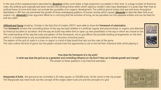
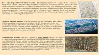
SlideShare a Scribd company logo
The grid as generator (1972) _ Leslie Martin
URBAN DESIGN 1
Presented by: Rachid Kantar (EXDUH9) Presented to: Arpad. Szabo -associate professor-
The activity called city planning, or urban design, or just planning, is being
sharply questioned.
For example roads can be proposed without any real consideration of their
effect on environment; the answer to such proposals could be that they are
just not planning at all.
what is being questioned is the adequacy of the assumptions on which
planning doctrine is based.
What are those assumptions?
The first, which stems from the work of the Viennese writer Camillo Sitte,
To Sitte the total city plan is the inspired and the all encompassing work of art.
But Sitte went further: civic art must be an expression of the life of the community, and finally ‘’’works of art cannot be created by
committee but only by a single individual’’’’ .
The planner then is the inspired artist expressing in The total city plan the ambitions of a society.
The predominance of the visual image is evident in some proposals that work for the preservation of the past: it is again evident in
the work of those that would carry us on, by an imagery of mechanisms, into the future
The second line of doctrine is severely practical.
It is the basis of those planning surveys in which uses are quantified, sorted out and zoned into particular areas; population densities are assessed
and growth and change predicted
Now it is precisely these two aspects of planning (the first concerned with visual images and the second with
procedure, and sometimes of course used in combination by planners), that were attacked by Mrs Jane Jacobs in her
book ‘’The Death and Life of Great American Cities’’
For Mrs Jacobs, a city can never be the total work of art, nor can there ever be the statistically organized city.
Indeed, to Mrs Jacobs, Planning is a restrictive imposition: the areas of cities ‘’in which people have lived are a natural
growth … as natural as the beds of oysters’’. Planning, , is essentially artificial
Christopher Alexander essay’s ‘A city is not a tree’ says:
I want to call those cities that have arisen spontaneously over many many years ‘natural cities’.
And I shall call those cities or parts of cities that have been deliberately created by planners ‘artificial cities’.
Siena, Liverpool, Kyoto, Manhattan, are examples of natural cities.
Levittown, Chandigarh and the British New Towns are examples of artificial cities.
Would it be true to say that all old towns are a kind of spontaneous growth and that there have never been ‘artificial’ or consciously planned towns in history?
What about the four hundred extremely well documented cases of new towns that Professor Beresford has collected for the Middle Ages in England,?
What about the mediaeval towns such as those built in Gascony between 1250 and 1318 on a systematic gridiron plan?
All these towns were highly artificial in Alexander’s sense.
The planted town, as Professor Beresford observes, ‘’is not a prisoner of an architectural past: it has no past’’.
A recent book by John Reps, ’’The Making of Urban America (1965)’’ .He points out that there is a sense in which
not merely cities but the whole of Western America is developed within an artificial frame: ‘‘the giant gridiron
imposed upon the natural landscape by … the land ordinance of 1785’’ ,areas must be reserved for agriculture as
well as plots for building.: cities and their dependent agricultural areas are not separate elements.. The process
demands a geometry and a relationship of numbers worked out in advance and irrespective of site. the plans of
Savannah and Georgetown, are typical examples of this kind of thought.
William Penn’s plan for Philadelphia, the plans of such towns as Louisville, Cincinnati, Cleveland, New York City
itself, Chicago and San Francisco, are all built on the basis of a preconceived frame.
Willmott and Young, studying ‘’kinship in the East End of London (1957)’’, were able to show the framework of urbanization.
That framework remains the controlling factor of the way we build whether it is artificial, regular and preconceived, or organic and distorted
by historical accident or accretion. And the way we build may either limit or open up new possibilities in the way in which we choose to live.
The understanding of the way the scale and pattern of this framework, net or grid affects the possible building arrangements on the land
within it, is fundamental to any reconsideration of the structure of existing towns.
The pattern of the grid of roads in a town or region is a kind of play board that sets out the rules of the game.
The rules outline the kind of game; but the players should have the opportunity to use to the full their individual skills whilst playing it.
How does the framework of a city work?
In what way does the grid act as a generator and controlling influence on city form? How can it tolerate growth and change?
The answer to these questions is by historical examples,
Margravate of Azilia , the ground to be controlled is 20 miles square, or 256,000 acres. At the centre is the city proper.
The Margravate was never built, but the concept of the single urban–rural unit and the principle of a grid
In the case of the mediaeval towns described by Beresford, whilst some failed, a high proportion succeeded in their time. In a large number of American
cities, the artificial grid originally laid down remains the working frame within which vigorous modern cities have developed. It is quite clear then that an
artificial frame of some kind does not exclude the possibility of an organic development. The artificial grid of streets that was laid down throughout
Manhattan in 1811 has not prevented the growth of those overlapping patterns of human activity which caused Alexander to describe New York as an
organic city. Alexander’s main argument What he is criticizing that the activities of living can be parcelled out into separate entities and can be fixed for
ever by a plan.
The second example of.Manhattan. In 1811 the largest city grid ever to be created. Taylor’s plan in
1811 the special State Commissioners confirmed this in an 8 ft long plan which plotted the
numbered street system of Manhattan as far north as 155th Street. The plan showed 12 north–
south avenues each 100 ft wide and 155 cross streets each 66 ft wide. The size of the rectangular
building plots set out by this grid are generally 600 ft by 200 ft. There were some public open
spaces. (Central Park was of course carved out later.)
The third example of Chicago, a city grid is suggested by Thomas Jefferson and passed by Congress
in 1785. a huge network of survey lines was thrown across all the land north and west of the Ohio
river (Robinson 1916). The base lines and principal meridians of the survey divided the landscape
into squares 36 miles each side. These in turn were subdivided into 6-mile squares or townships
and further divided into 36 sections each one mile square. The mile squares are then subdivided by
acreage: the quarter section 160 acres with further possible subdivisions of 80, 40, 20, 10 or 5 acres.
The 5-acre sites lend themselves to further division into rectangular city blocks (not unlike those of
Manhattan) Chicago was not much more than a few log cabins on a swamp
Now it is this city grid of Savannah that can be used as a first example, a grid of one mile square sub-divides a rectangle
nearly 10 miles long and 6 miles deep. Thirty-nine of these squares remain wooded areas: within this primary subdivision,
further subdivisions create farms of 44 acres and 5-acre garden plots.The unit of the Savannah grid is square: it is called
a ward and is separated from its neighbours by wide streets. Within each square (or ward) building plots for houses are
arranged along two sides, the centre itself is open, and on each side of this open square are sites for shops and public
buildings.. In 1733 there were four units: in 1856 no less than twenty-four. The central open spaces of each ward are
connected in one direction by intermediate roads
A balance is maintained between the plot, the amount of building that it can reasonably support and the street
system that serves this. But as the pressure for floor space increases, the building form changes intensively at
certain nodal points (Fig. 8.2)
Each one is rectangular. Each one has admitted change in the form and style of its building. Each one has admitted growth, by
intensification of land use or by extension. each one offers different possibilities and choices of building and of living
-Savannah, as it grew, tended to produce a green and dispersed city of open squares (Fig. 8.1).
-In Manhattan, the small scale subdivision of the grid and the exceptional pressure to increase floor space within this, forced
buildings upwards.
-Chicago spread, continually opening out the pattern of its grid
Fig. 8.1
Fig. 8.2
The balance between area of plot, area of floor space and area of street has disappeared. A grid of any kind appears to be a rigid
imposition on the natural landscape. It is this reaction against the grid that is voiced by Olmstead and Vaux writing in support of
their design for Central Park in 1863: ‘’The time will come when New York will be built up, when all the grading and the filling will
be done and the picturesquely varied rocky formation of the island will have been converted into formations for rows of
monotonous straight streets and piles of erect buildings’’’
Central Park itself is an attempt to imitate nature and to recreate wild scenery within the grid.
And at the end of the century, the Chicago Fair (1893), Cass Gilbert’s schemes in Washington (1900), and the plans for San
Francisco (1905) and Chicago (1909) by Burnham are another attempt to transform the urban desert by means of vistas and focal
points, into the ‘city beautiful’.
It is not possible to deny the force behind the criticisms of the grid. It can result in monotony: so can a curvilinear suburbia. It
can fail to work: so can the organic city.
It is now possible to extract some principles. Artificial grids of various kinds have been laid down.
The grid, can accept and respond to growth and change. It can be developed unimaginatively and monotonously or with
great freedom. There can be a point at which the original grid fails to respond to new demands (Fig. 8.3). Fig. 8.3
As in Manhattan, it congeals. And it is at this point that we must try to discover from the old framework a new
ordering principle that will open up new opportunities for elaboration by use. It is precisely this that Le Corbusier
underlined when he paid his first visit to New York in 1935 and made the comment: ‘‘What about the road?’’ (Le
Corbusier 1939, 1947.)
Fig. 8.4
(Fig. 8.5)
Ebenezer Howard’s direct successor in this field was Raymond Unwin. In an essay ‘’Nothing gained by overcrowding’’ he
presents two diagrams:
*One is typical development of parallel rows of dwellings the other places dwellings round the perimeter.
*The second places fewer houses on the land but when all the variables are taken into account (including the savings on
road costs) total development costs can be cut.
From the point of view of theory, the important aspect of this study is the recognition of related factors: the land available,
the built form placed on this, and the roads necessary to serve these. One of Unwin’s most forceful contributions to theory is
his recognition of the fact that ‘‘the area of a circle is increased not in the direct proportion to the distance to be travelled
from the centre to the circumference, but in proportion to the square of that distance’’
The principle is demonstrated again in Fresnel’s diagram (Fig. 8.5)
Raymond Unwin.
The diagrams by which he illustrates this remark show the regenerative process that is necessary (Fig. 8.4).
By increasing the size of the street net in Manhattan, Le Corbusier shows that the grid ceases to restrict. New
building arrangements become possible and the balance between plot, building and street can be restored.
The outer band in the square form of this diagram has exactly the same area as the central square ..This central
square (which can be called the pavilion) and the outer annulus (which can be called the court) are two ways of
placing building on the land. .
On any large site a development covering 50% of the site could be plotted as forty-nine pavilions, as shown in
(Fig. 8.6), and exactly the same site cover can be plotted in court form.
The forty-nine pavilions can be plotted in a form which is closer to that which they would assume as buildings
(that is low slab with a tower form over this). This can now be compared with its antiform: the same floor space
planned as courts (Fig. 8.7). The comparison must be exact; the same site area, the same volume of building, the
same internal depth of room.
(Fig. 8.6)
(Fig. 8.7)
.Professor Buchanan, saw that most of the cities are built up from a collection of localities. He called these
‘‘environmental areas’’.
they are areas in which a pattern of related uses holds together: local housing, shopping, schools, etc..
They form, in Professor Buchanan’s terms, ‘the rooms of a town’.
He was trying to recognize and define these working areas and to place the net of roads in the cracks between
them .
Professor Buchanan was able to suggest some possible sizes for the networks so he selected St Marylebone as
one of his test areas.
This happens to adjoin the main London University site (already defined as a precinct in the London Plan) and
this in turn is contiguous with the area around the Foundling Estate which has been used in some Cambridge
studies of the built form (Fig. 8.9). All three areas are approximately equal in size. It developed a cohesion of its
own. How did this happen? (Fig. 8.9)
A plan of 1790 divides the land into building plots by its network of streets and squares.
By 1900 the area could have been described by the language that Mrs Jacobs applies to Greenwich Village.
The intellectuals were there: so were the working Londoners: so were the Italians around their hospital in Queen
Square. There were handsome houses; tenements and mews; hotels and boarding houses.
The area had its own Underground station and its own shopping area along Marchmont Street.
Redevelopment of sites for offices created taller and thicker buildings. The hospitals, which needed to expand,
were hemmed in by surrounding development. The pattern congealed. In this situation only a new framework can
open up a free development.
And if Professor Buchanan’s surrounding road net is accepted as a basis for the development of the environmental
area, the problem can be seen within a new unifying context.
What sort of advantages could a rearrangement of the built form now create?
(Fig. 8.10):
Professor Buchanan in his study area outlined three possible solutions with
progressive standards of improvement. his partial solution leads to an extensive
road and parking system at ground level.
But, Professor Buchanan ask himself :what building complications does it produce
and what sort of an environment does it create? Is it in fact worth building?
Professor Buchanan’s range of choices could in fact be extended by applying some
of the theoretical work which has been described. And when this is done the
results are significantly different. The boundaries of the total area that are being
considered have been defined by this new scale of the road network: the grid.
Within this, the existing floor space can be assessed (Fig. 8.10): 34% of the site is
occupied by housing: 25% by roads: 15% by office and commercial use: 12% is
open space. In addition there is an important shopping street, a major hospital
and several schools and educational buildings.
Quantities of built and open
space in the Foundling Area.
-a- -b-
-a- Possible geometric layout of the same
quantities of built space in perimeter
form.
-b-
First, the shopping street, Marchmont Street, could be established as a north/south pedestrian route associated with the Underground and some
housing. If all the office space which is at present scattered throughout the area could be placed in a single line of buildings around the perimeter of
the area (where some of it already is), it need be no higher than eight storeys. All the housing at present in the area could be placed within another
band of buildings sited inside this and no higher than five storeys. Like leaving the centre open, which would be a park-like area about the same size
as St James’s Park (Fig. 8.11).
There need be no tall buildings, unless they are specifically wanted. All the housing could look onto a park.
-a-
The existing plot layout and building development in an area of London that
might be regarded as an environmental room. But it is subdivided by roads
and the limited size of the building plot increasingly forces development
upward.
(Fig. 8.11)
-b-
The same area as that in 8.11a. The road network is now enlarged and runs around
the boundary of the area. Theoretically an entirely new disposition of buildings is
possible and the illustration shows exactly the same amount of floor space in a new
form. Tall buildings are no longer necessary: the buildings themselves have a new
freedom for development and a considerable area of open space is discovered.
-a- -b-

More Related Content

What's hot

Mainstream concepts in urban design_Barrie Shelton
Mainstream concepts in urban design_Barrie SheltonMainstream concepts in urban design_Barrie Shelton
Mainstream concepts in urban design_Barrie Shelton
jpblancomoya
 
Urban Form and Design: Urban Design Outside Euro-American Contexts
Urban Form and Design: Urban Design Outside Euro-American ContextsUrban Form and Design: Urban Design Outside Euro-American Contexts
Urban Form and Design: Urban Design Outside Euro-American Contexts
Anuradha Mukherji
 
Fina ldoxidas
Fina ldoxidasFina ldoxidas
Fina ldoxidas
Amy Arora
 

What's hot (20)

SusanSpencerThesis
SusanSpencerThesisSusanSpencerThesis
SusanSpencerThesis
 
Urban Design basic rules
Urban Design basic rulesUrban Design basic rules
Urban Design basic rules
 
Modern urban planning theory and practice
Modern urban planning theory and practice Modern urban planning theory and practice
Modern urban planning theory and practice
 
Forces that shaped Frank Lloyd Wright, coming directly from the root.
Forces that shaped Frank Lloyd Wright, coming directly from the root.Forces that shaped Frank Lloyd Wright, coming directly from the root.
Forces that shaped Frank Lloyd Wright, coming directly from the root.
 
Review of 'Beyond Suburbia: Rise of the Technoburb'
Review of 'Beyond Suburbia: Rise of the Technoburb'Review of 'Beyond Suburbia: Rise of the Technoburb'
Review of 'Beyond Suburbia: Rise of the Technoburb'
 
Kevin lynch
Kevin lynchKevin lynch
Kevin lynch
 
Edmund bacon
Edmund baconEdmund bacon
Edmund bacon
 
Frank lloyd wright
Frank lloyd wrightFrank lloyd wright
Frank lloyd wright
 
Arc251 02 the-scope-of-urban-design
Arc251 02 the-scope-of-urban-designArc251 02 the-scope-of-urban-design
Arc251 02 the-scope-of-urban-design
 
urban design
urban design urban design
urban design
 
Urban complexity's role in a practical emergent urbanism
Urban complexity's role in a practical emergent urbanismUrban complexity's role in a practical emergent urbanism
Urban complexity's role in a practical emergent urbanism
 
Lecture 12 Theories of Urban Spatial Design
Lecture 12 Theories of Urban Spatial DesignLecture 12 Theories of Urban Spatial Design
Lecture 12 Theories of Urban Spatial Design
 
Mainstream concepts in urban design_Barrie Shelton
Mainstream concepts in urban design_Barrie SheltonMainstream concepts in urban design_Barrie Shelton
Mainstream concepts in urban design_Barrie Shelton
 
Urban Form and Design: Urban Design Outside Euro-American Contexts
Urban Form and Design: Urban Design Outside Euro-American ContextsUrban Form and Design: Urban Design Outside Euro-American Contexts
Urban Form and Design: Urban Design Outside Euro-American Contexts
 
UVCSp15Module13.2
UVCSp15Module13.2UVCSp15Module13.2
UVCSp15Module13.2
 
What is urban design?
What is urban design?What is urban design?
What is urban design?
 
KaminskaWUFINAL
KaminskaWUFINALKaminskaWUFINAL
KaminskaWUFINAL
 
Fina ldoxidas
Fina ldoxidasFina ldoxidas
Fina ldoxidas
 
100greatplanningbooks
100greatplanningbooks100greatplanningbooks
100greatplanningbooks
 
kevin lynch theory five elements - urban design
kevin lynch theory five elements - urban designkevin lynch theory five elements - urban design
kevin lynch theory five elements - urban design
 

Similar to Urban design - RACHID KANTAR

Design Thesis - Strengthening Community Through the Post-Industrial Landscape
Design Thesis - Strengthening Community Through the Post-Industrial LandscapeDesign Thesis - Strengthening Community Through the Post-Industrial Landscape
Design Thesis - Strengthening Community Through the Post-Industrial Landscape
Matthew Greene
 
What is a City”Architectural Record (1937)Lewis Mumfor.docx
What is a City”Architectural Record (1937)Lewis Mumfor.docxWhat is a City”Architectural Record (1937)Lewis Mumfor.docx
What is a City”Architectural Record (1937)Lewis Mumfor.docx
philipnelson29183
 

Similar to Urban design - RACHID KANTAR (20)

ARCH416NewUrbanismSmartGrowth
ARCH416NewUrbanismSmartGrowthARCH416NewUrbanismSmartGrowth
ARCH416NewUrbanismSmartGrowth
 
City life and new urbanism
City life and new urbanismCity life and new urbanism
City life and new urbanism
 
SUMMER15UVC14PtTwo
SUMMER15UVC14PtTwoSUMMER15UVC14PtTwo
SUMMER15UVC14PtTwo
 
Jane Jacobs- urban activist
Jane Jacobs- urban activistJane Jacobs- urban activist
Jane Jacobs- urban activist
 
06. (1).pdf
06. (1).pdf06. (1).pdf
06. (1).pdf
 
UVCSp15Module13.1
UVCSp15Module13.1UVCSp15Module13.1
UVCSp15Module13.1
 
akaber note book1.pdf
akaber note book1.pdfakaber note book1.pdf
akaber note book1.pdf
 
Professor Alan Powers - Milton Keynes or Civilia? Real and imagined utopia of...
Professor Alan Powers - Milton Keynes or Civilia? Real and imagined utopia of...Professor Alan Powers - Milton Keynes or Civilia? Real and imagined utopia of...
Professor Alan Powers - Milton Keynes or Civilia? Real and imagined utopia of...
 
Design Thesis - Strengthening Community Through the Post-Industrial Landscape
Design Thesis - Strengthening Community Through the Post-Industrial LandscapeDesign Thesis - Strengthening Community Through the Post-Industrial Landscape
Design Thesis - Strengthening Community Through the Post-Industrial Landscape
 
What is a City”Architectural Record (1937)Lewis Mumfor.docx
What is a City”Architectural Record (1937)Lewis Mumfor.docxWhat is a City”Architectural Record (1937)Lewis Mumfor.docx
What is a City”Architectural Record (1937)Lewis Mumfor.docx
 
BROADACRE BY F.L. WRIGHT
BROADACRE BY F.L. WRIGHTBROADACRE BY F.L. WRIGHT
BROADACRE BY F.L. WRIGHT
 
1960_Kevin_Lynch_The_Image_of_The_City_book.pdf
1960_Kevin_Lynch_The_Image_of_The_City_book.pdf1960_Kevin_Lynch_The_Image_of_The_City_book.pdf
1960_Kevin_Lynch_The_Image_of_The_City_book.pdf
 
1960_Kevin_Lynch_The_Image_of_The_City_book.pdf
1960_Kevin_Lynch_The_Image_of_The_City_book.pdf1960_Kevin_Lynch_The_Image_of_The_City_book.pdf
1960_Kevin_Lynch_The_Image_of_The_City_book.pdf
 
1960_Kevin_Lynch_The_Image_of_The_City_book.pdf
1960_Kevin_Lynch_The_Image_of_The_City_book.pdf1960_Kevin_Lynch_The_Image_of_The_City_book.pdf
1960_Kevin_Lynch_The_Image_of_The_City_book.pdf
 
The critique to the industrial city
The critique to the industrial cityThe critique to the industrial city
The critique to the industrial city
 
PLAN3-REPORT-PDF
PLAN3-REPORT-PDFPLAN3-REPORT-PDF
PLAN3-REPORT-PDF
 
lecture one (1).pptx
lecture one (1).pptxlecture one (1).pptx
lecture one (1).pptx
 
Daup mupd-upl-2015-lecture 3
Daup mupd-upl-2015-lecture 3Daup mupd-upl-2015-lecture 3
Daup mupd-upl-2015-lecture 3
 
Development of Settlements - Planning Perspectives
Development of Settlements - Planning PerspectivesDevelopment of Settlements - Planning Perspectives
Development of Settlements - Planning Perspectives
 
City Beautiful
City BeautifulCity Beautiful
City Beautiful
 

Recently uploaded

Research about Venice ppt for grade 6f anas
Research about Venice ppt for grade 6f anasResearch about Venice ppt for grade 6f anas
Research about Venice ppt for grade 6f anas
anasabutalha2013
 
Heuristic Evaluation of System & Application
Heuristic Evaluation of System & ApplicationHeuristic Evaluation of System & Application
Heuristic Evaluation of System & Application
Jaime Brown
 
National-Learning-Camp 2024 deped....pptx
National-Learning-Camp 2024 deped....pptxNational-Learning-Camp 2024 deped....pptx
National-Learning-Camp 2024 deped....pptx
AlecAnidul
 

Recently uploaded (14)

Art Nouveau Movement Presentation for Art History.
Art Nouveau Movement Presentation for Art History.Art Nouveau Movement Presentation for Art History.
Art Nouveau Movement Presentation for Art History.
 
Design lessons from Singapore | Volume 3
Design lessons from Singapore | Volume 3Design lessons from Singapore | Volume 3
Design lessons from Singapore | Volume 3
 
CA OFFICE office office office _VIEWS.pdf
CA OFFICE office office office _VIEWS.pdfCA OFFICE office office office _VIEWS.pdf
CA OFFICE office office office _VIEWS.pdf
 
The Design Code Google Developer Student Club.pptx
The Design Code Google Developer Student Club.pptxThe Design Code Google Developer Student Club.pptx
The Design Code Google Developer Student Club.pptx
 
Research about Venice ppt for grade 6f anas
Research about Venice ppt for grade 6f anasResearch about Venice ppt for grade 6f anas
Research about Venice ppt for grade 6f anas
 
The Evolution of Fashion Trends: History to Fashion
The Evolution of Fashion Trends: History to FashionThe Evolution of Fashion Trends: History to Fashion
The Evolution of Fashion Trends: History to Fashion
 
PORTFOLIO FABIANA VILLANI ARCHITECTURE.pdf
PORTFOLIO FABIANA VILLANI ARCHITECTURE.pdfPORTFOLIO FABIANA VILLANI ARCHITECTURE.pdf
PORTFOLIO FABIANA VILLANI ARCHITECTURE.pdf
 
Heuristic Evaluation of System & Application
Heuristic Evaluation of System & ApplicationHeuristic Evaluation of System & Application
Heuristic Evaluation of System & Application
 
Common Designing Mistakes and How to avoid them
Common Designing Mistakes and How to avoid themCommon Designing Mistakes and How to avoid them
Common Designing Mistakes and How to avoid them
 
Claire's designing portfolio presentation
Claire's designing portfolio presentationClaire's designing portfolio presentation
Claire's designing portfolio presentation
 
National-Learning-Camp 2024 deped....pptx
National-Learning-Camp 2024 deped....pptxNational-Learning-Camp 2024 deped....pptx
National-Learning-Camp 2024 deped....pptx
 
BIT- Pinal .H. Prajapati Graphic Designer
BIT- Pinal .H. Prajapati  Graphic DesignerBIT- Pinal .H. Prajapati  Graphic Designer
BIT- Pinal .H. Prajapati Graphic Designer
 
Pitch Presentation for Service Design in Technology
Pitch Presentation for Service Design in TechnologyPitch Presentation for Service Design in Technology
Pitch Presentation for Service Design in Technology
 
Spring 2024 wkrm_Enhancing Campus Mobility.pdf
Spring 2024 wkrm_Enhancing Campus Mobility.pdfSpring 2024 wkrm_Enhancing Campus Mobility.pdf
Spring 2024 wkrm_Enhancing Campus Mobility.pdf
 

Urban design - RACHID KANTAR

  • 1. The grid as generator (1972) _ Leslie Martin URBAN DESIGN 1 Presented by: Rachid Kantar (EXDUH9) Presented to: Arpad. Szabo -associate professor-
  • 2. The activity called city planning, or urban design, or just planning, is being sharply questioned. For example roads can be proposed without any real consideration of their effect on environment; the answer to such proposals could be that they are just not planning at all. what is being questioned is the adequacy of the assumptions on which planning doctrine is based. What are those assumptions? The first, which stems from the work of the Viennese writer Camillo Sitte, To Sitte the total city plan is the inspired and the all encompassing work of art. But Sitte went further: civic art must be an expression of the life of the community, and finally ‘’’works of art cannot be created by committee but only by a single individual’’’’ . The planner then is the inspired artist expressing in The total city plan the ambitions of a society. The predominance of the visual image is evident in some proposals that work for the preservation of the past: it is again evident in the work of those that would carry us on, by an imagery of mechanisms, into the future The second line of doctrine is severely practical. It is the basis of those planning surveys in which uses are quantified, sorted out and zoned into particular areas; population densities are assessed and growth and change predicted Now it is precisely these two aspects of planning (the first concerned with visual images and the second with procedure, and sometimes of course used in combination by planners), that were attacked by Mrs Jane Jacobs in her book ‘’The Death and Life of Great American Cities’’ For Mrs Jacobs, a city can never be the total work of art, nor can there ever be the statistically organized city. Indeed, to Mrs Jacobs, Planning is a restrictive imposition: the areas of cities ‘’in which people have lived are a natural growth … as natural as the beds of oysters’’. Planning, , is essentially artificial
  • 3. Christopher Alexander essay’s ‘A city is not a tree’ says: I want to call those cities that have arisen spontaneously over many many years ‘natural cities’. And I shall call those cities or parts of cities that have been deliberately created by planners ‘artificial cities’. Siena, Liverpool, Kyoto, Manhattan, are examples of natural cities. Levittown, Chandigarh and the British New Towns are examples of artificial cities. Would it be true to say that all old towns are a kind of spontaneous growth and that there have never been ‘artificial’ or consciously planned towns in history? What about the four hundred extremely well documented cases of new towns that Professor Beresford has collected for the Middle Ages in England,? What about the mediaeval towns such as those built in Gascony between 1250 and 1318 on a systematic gridiron plan? All these towns were highly artificial in Alexander’s sense. The planted town, as Professor Beresford observes, ‘’is not a prisoner of an architectural past: it has no past’’. A recent book by John Reps, ’’The Making of Urban America (1965)’’ .He points out that there is a sense in which not merely cities but the whole of Western America is developed within an artificial frame: ‘‘the giant gridiron imposed upon the natural landscape by … the land ordinance of 1785’’ ,areas must be reserved for agriculture as well as plots for building.: cities and their dependent agricultural areas are not separate elements.. The process demands a geometry and a relationship of numbers worked out in advance and irrespective of site. the plans of Savannah and Georgetown, are typical examples of this kind of thought. William Penn’s plan for Philadelphia, the plans of such towns as Louisville, Cincinnati, Cleveland, New York City itself, Chicago and San Francisco, are all built on the basis of a preconceived frame.
  • 4. Willmott and Young, studying ‘’kinship in the East End of London (1957)’’, were able to show the framework of urbanization. That framework remains the controlling factor of the way we build whether it is artificial, regular and preconceived, or organic and distorted by historical accident or accretion. And the way we build may either limit or open up new possibilities in the way in which we choose to live. The understanding of the way the scale and pattern of this framework, net or grid affects the possible building arrangements on the land within it, is fundamental to any reconsideration of the structure of existing towns. The pattern of the grid of roads in a town or region is a kind of play board that sets out the rules of the game. The rules outline the kind of game; but the players should have the opportunity to use to the full their individual skills whilst playing it. How does the framework of a city work? In what way does the grid act as a generator and controlling influence on city form? How can it tolerate growth and change? The answer to these questions is by historical examples, Margravate of Azilia , the ground to be controlled is 20 miles square, or 256,000 acres. At the centre is the city proper. The Margravate was never built, but the concept of the single urban–rural unit and the principle of a grid In the case of the mediaeval towns described by Beresford, whilst some failed, a high proportion succeeded in their time. In a large number of American cities, the artificial grid originally laid down remains the working frame within which vigorous modern cities have developed. It is quite clear then that an artificial frame of some kind does not exclude the possibility of an organic development. The artificial grid of streets that was laid down throughout Manhattan in 1811 has not prevented the growth of those overlapping patterns of human activity which caused Alexander to describe New York as an organic city. Alexander’s main argument What he is criticizing that the activities of living can be parcelled out into separate entities and can be fixed for ever by a plan.
  • 5. The second example of.Manhattan. In 1811 the largest city grid ever to be created. Taylor’s plan in 1811 the special State Commissioners confirmed this in an 8 ft long plan which plotted the numbered street system of Manhattan as far north as 155th Street. The plan showed 12 north– south avenues each 100 ft wide and 155 cross streets each 66 ft wide. The size of the rectangular building plots set out by this grid are generally 600 ft by 200 ft. There were some public open spaces. (Central Park was of course carved out later.) The third example of Chicago, a city grid is suggested by Thomas Jefferson and passed by Congress in 1785. a huge network of survey lines was thrown across all the land north and west of the Ohio river (Robinson 1916). The base lines and principal meridians of the survey divided the landscape into squares 36 miles each side. These in turn were subdivided into 6-mile squares or townships and further divided into 36 sections each one mile square. The mile squares are then subdivided by acreage: the quarter section 160 acres with further possible subdivisions of 80, 40, 20, 10 or 5 acres. The 5-acre sites lend themselves to further division into rectangular city blocks (not unlike those of Manhattan) Chicago was not much more than a few log cabins on a swamp Now it is this city grid of Savannah that can be used as a first example, a grid of one mile square sub-divides a rectangle nearly 10 miles long and 6 miles deep. Thirty-nine of these squares remain wooded areas: within this primary subdivision, further subdivisions create farms of 44 acres and 5-acre garden plots.The unit of the Savannah grid is square: it is called a ward and is separated from its neighbours by wide streets. Within each square (or ward) building plots for houses are arranged along two sides, the centre itself is open, and on each side of this open square are sites for shops and public buildings.. In 1733 there were four units: in 1856 no less than twenty-four. The central open spaces of each ward are connected in one direction by intermediate roads
  • 6. A balance is maintained between the plot, the amount of building that it can reasonably support and the street system that serves this. But as the pressure for floor space increases, the building form changes intensively at certain nodal points (Fig. 8.2) Each one is rectangular. Each one has admitted change in the form and style of its building. Each one has admitted growth, by intensification of land use or by extension. each one offers different possibilities and choices of building and of living -Savannah, as it grew, tended to produce a green and dispersed city of open squares (Fig. 8.1). -In Manhattan, the small scale subdivision of the grid and the exceptional pressure to increase floor space within this, forced buildings upwards. -Chicago spread, continually opening out the pattern of its grid Fig. 8.1 Fig. 8.2 The balance between area of plot, area of floor space and area of street has disappeared. A grid of any kind appears to be a rigid imposition on the natural landscape. It is this reaction against the grid that is voiced by Olmstead and Vaux writing in support of their design for Central Park in 1863: ‘’The time will come when New York will be built up, when all the grading and the filling will be done and the picturesquely varied rocky formation of the island will have been converted into formations for rows of monotonous straight streets and piles of erect buildings’’’ Central Park itself is an attempt to imitate nature and to recreate wild scenery within the grid. And at the end of the century, the Chicago Fair (1893), Cass Gilbert’s schemes in Washington (1900), and the plans for San Francisco (1905) and Chicago (1909) by Burnham are another attempt to transform the urban desert by means of vistas and focal points, into the ‘city beautiful’. It is not possible to deny the force behind the criticisms of the grid. It can result in monotony: so can a curvilinear suburbia. It can fail to work: so can the organic city. It is now possible to extract some principles. Artificial grids of various kinds have been laid down. The grid, can accept and respond to growth and change. It can be developed unimaginatively and monotonously or with great freedom. There can be a point at which the original grid fails to respond to new demands (Fig. 8.3). Fig. 8.3
  • 7. As in Manhattan, it congeals. And it is at this point that we must try to discover from the old framework a new ordering principle that will open up new opportunities for elaboration by use. It is precisely this that Le Corbusier underlined when he paid his first visit to New York in 1935 and made the comment: ‘‘What about the road?’’ (Le Corbusier 1939, 1947.) Fig. 8.4 (Fig. 8.5) Ebenezer Howard’s direct successor in this field was Raymond Unwin. In an essay ‘’Nothing gained by overcrowding’’ he presents two diagrams: *One is typical development of parallel rows of dwellings the other places dwellings round the perimeter. *The second places fewer houses on the land but when all the variables are taken into account (including the savings on road costs) total development costs can be cut. From the point of view of theory, the important aspect of this study is the recognition of related factors: the land available, the built form placed on this, and the roads necessary to serve these. One of Unwin’s most forceful contributions to theory is his recognition of the fact that ‘‘the area of a circle is increased not in the direct proportion to the distance to be travelled from the centre to the circumference, but in proportion to the square of that distance’’ The principle is demonstrated again in Fresnel’s diagram (Fig. 8.5) Raymond Unwin. The diagrams by which he illustrates this remark show the regenerative process that is necessary (Fig. 8.4). By increasing the size of the street net in Manhattan, Le Corbusier shows that the grid ceases to restrict. New building arrangements become possible and the balance between plot, building and street can be restored.
  • 8. The outer band in the square form of this diagram has exactly the same area as the central square ..This central square (which can be called the pavilion) and the outer annulus (which can be called the court) are two ways of placing building on the land. . On any large site a development covering 50% of the site could be plotted as forty-nine pavilions, as shown in (Fig. 8.6), and exactly the same site cover can be plotted in court form. The forty-nine pavilions can be plotted in a form which is closer to that which they would assume as buildings (that is low slab with a tower form over this). This can now be compared with its antiform: the same floor space planned as courts (Fig. 8.7). The comparison must be exact; the same site area, the same volume of building, the same internal depth of room. (Fig. 8.6) (Fig. 8.7) .Professor Buchanan, saw that most of the cities are built up from a collection of localities. He called these ‘‘environmental areas’’. they are areas in which a pattern of related uses holds together: local housing, shopping, schools, etc.. They form, in Professor Buchanan’s terms, ‘the rooms of a town’. He was trying to recognize and define these working areas and to place the net of roads in the cracks between them . Professor Buchanan was able to suggest some possible sizes for the networks so he selected St Marylebone as one of his test areas. This happens to adjoin the main London University site (already defined as a precinct in the London Plan) and this in turn is contiguous with the area around the Foundling Estate which has been used in some Cambridge studies of the built form (Fig. 8.9). All three areas are approximately equal in size. It developed a cohesion of its own. How did this happen? (Fig. 8.9)
  • 9. A plan of 1790 divides the land into building plots by its network of streets and squares. By 1900 the area could have been described by the language that Mrs Jacobs applies to Greenwich Village. The intellectuals were there: so were the working Londoners: so were the Italians around their hospital in Queen Square. There were handsome houses; tenements and mews; hotels and boarding houses. The area had its own Underground station and its own shopping area along Marchmont Street. Redevelopment of sites for offices created taller and thicker buildings. The hospitals, which needed to expand, were hemmed in by surrounding development. The pattern congealed. In this situation only a new framework can open up a free development. And if Professor Buchanan’s surrounding road net is accepted as a basis for the development of the environmental area, the problem can be seen within a new unifying context. What sort of advantages could a rearrangement of the built form now create? (Fig. 8.10): Professor Buchanan in his study area outlined three possible solutions with progressive standards of improvement. his partial solution leads to an extensive road and parking system at ground level. But, Professor Buchanan ask himself :what building complications does it produce and what sort of an environment does it create? Is it in fact worth building? Professor Buchanan’s range of choices could in fact be extended by applying some of the theoretical work which has been described. And when this is done the results are significantly different. The boundaries of the total area that are being considered have been defined by this new scale of the road network: the grid. Within this, the existing floor space can be assessed (Fig. 8.10): 34% of the site is occupied by housing: 25% by roads: 15% by office and commercial use: 12% is open space. In addition there is an important shopping street, a major hospital and several schools and educational buildings. Quantities of built and open space in the Foundling Area. -a- -b- -a- Possible geometric layout of the same quantities of built space in perimeter form. -b-
  • 10. First, the shopping street, Marchmont Street, could be established as a north/south pedestrian route associated with the Underground and some housing. If all the office space which is at present scattered throughout the area could be placed in a single line of buildings around the perimeter of the area (where some of it already is), it need be no higher than eight storeys. All the housing at present in the area could be placed within another band of buildings sited inside this and no higher than five storeys. Like leaving the centre open, which would be a park-like area about the same size as St James’s Park (Fig. 8.11). There need be no tall buildings, unless they are specifically wanted. All the housing could look onto a park. -a- The existing plot layout and building development in an area of London that might be regarded as an environmental room. But it is subdivided by roads and the limited size of the building plot increasingly forces development upward. (Fig. 8.11) -b- The same area as that in 8.11a. The road network is now enlarged and runs around the boundary of the area. Theoretically an entirely new disposition of buildings is possible and the illustration shows exactly the same amount of floor space in a new form. Tall buildings are no longer necessary: the buildings themselves have a new freedom for development and a considerable area of open space is discovered. -a- -b-