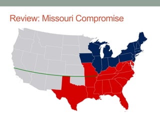
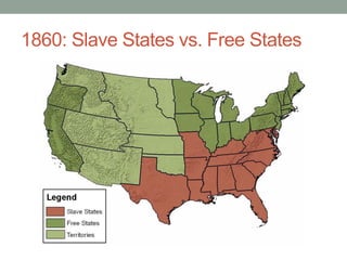
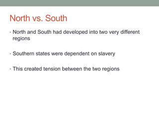
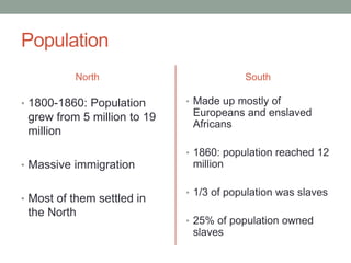
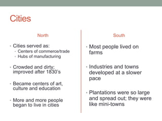
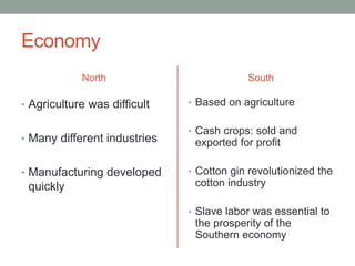
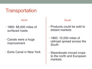
THE UNION IN PERIL
Mr. Palmer / US History
Review: Missouri Compromise
1860: Slave States vs. Free States
North vs. South
• North and South had developed into two very different
regions
• Southern states were dependent on slavery
• This created tension between the two regions
Geography
North
• Rocky, hilly and infertile
land; made farming difficult
• Forests provided timber for
shipbuilding
• Rivers ran down most
mountains into the Atlantic;
transported goods
• Waterfalls provided
waterpower for factories
South
• Climate very good for
agriculture
• Very good farmland
• Many broad, slow moving,
navigable rivers
Population
North
• 1800-1860: Population
grew from 5 million to 19
million
• Massive immigration
• Most of them settled in
the North
South
• Made up mostly of
Europeans and enslaved
Africans
• 1860: population reached 12
million
• 1/3 of population was slaves
• 25% of population owned
slaves
Cities
North
• Cities served as:
• Centers of commerce/trade
• Hubs of manufacturing
• Crowded and dirty;
improved after 1830’s
• Became centers of art,
culture and education
• More and more people
began to live in cities
South
• Most people lived on
farms
• Industries and towns
developed at a slower
pace
• Plantations were so large
and spread out; they were
like mini-towns
Economy
North
• Agriculture was difficult
• Many different industries
• Manufacturing developed
quickly
South
• Based on agriculture
• Cash crops: sold and
exported for profit
• Cotton gin revolutionized the
cotton industry
• Slave labor was essential to
the prosperity of the
Southern economy
Transportation
North
• 1860: 88,000 miles of
surfaced roads
• Canals were a huge
improvement
• Eerie Canal in New York
South
• Products could be sold to
distant markets
• 1860: 10,000 miles of
railroad spread across the
South
• Steamboats moved crops
to the north and European
markets

Union in peril

  • 1.
    THE UNION INPERIL Mr. Palmer / US History
  • 2.
  • 3.
    1860: Slave Statesvs. Free States
  • 4.
    North vs. South •North and South had developed into two very different regions • Southern states were dependent on slavery • This created tension between the two regions
  • 5.
    Geography North • Rocky, hillyand infertile land; made farming difficult • Forests provided timber for shipbuilding • Rivers ran down most mountains into the Atlantic; transported goods • Waterfalls provided waterpower for factories South • Climate very good for agriculture • Very good farmland • Many broad, slow moving, navigable rivers
  • 6.
    Population North • 1800-1860: Population grewfrom 5 million to 19 million • Massive immigration • Most of them settled in the North South • Made up mostly of Europeans and enslaved Africans • 1860: population reached 12 million • 1/3 of population was slaves • 25% of population owned slaves
  • 7.
    Cities North • Cities servedas: • Centers of commerce/trade • Hubs of manufacturing • Crowded and dirty; improved after 1830’s • Became centers of art, culture and education • More and more people began to live in cities South • Most people lived on farms • Industries and towns developed at a slower pace • Plantations were so large and spread out; they were like mini-towns
  • 8.
    Economy North • Agriculture wasdifficult • Many different industries • Manufacturing developed quickly South • Based on agriculture • Cash crops: sold and exported for profit • Cotton gin revolutionized the cotton industry • Slave labor was essential to the prosperity of the Southern economy
  • 9.
    Transportation North • 1860: 88,000miles of surfaced roads • Canals were a huge improvement • Eerie Canal in New York South • Products could be sold to distant markets • 1860: 10,000 miles of railroad spread across the South • Steamboats moved crops to the north and European markets