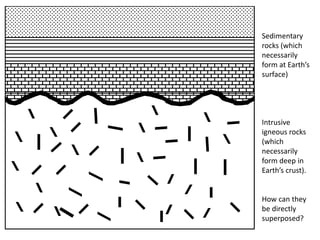
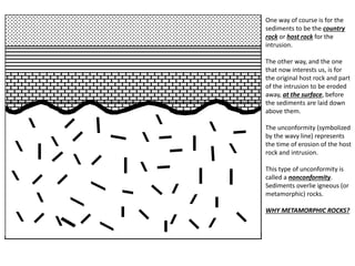
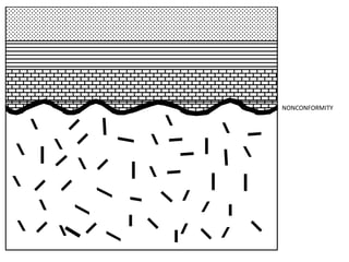
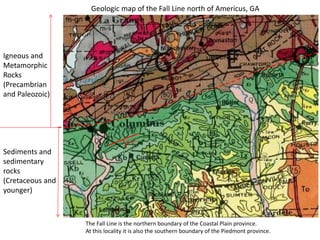
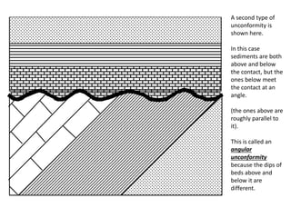
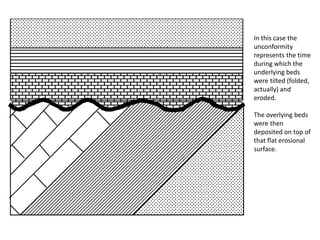
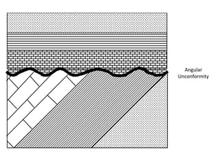
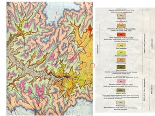
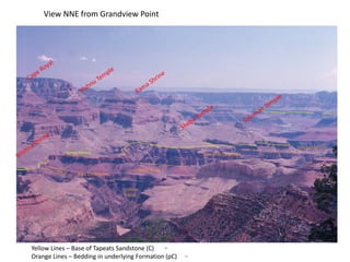
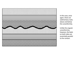
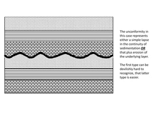
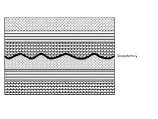
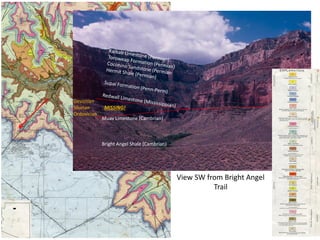
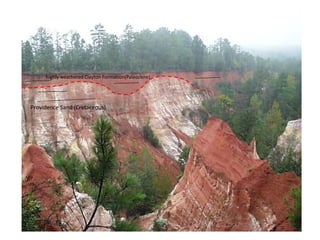
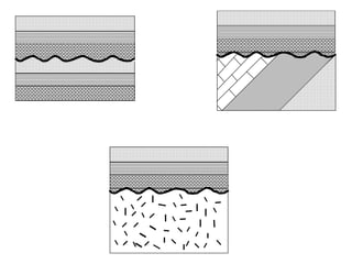
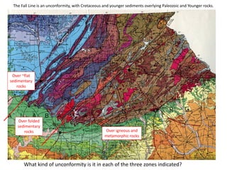
UNCONFORMITIES
• Unconformities are depositional contacts that
overlie rocks distinctly older than they are.
• They are often called “gaps” in the
sedimentary record.
• The contact represents time when no
sediment was deposited.
• Usually they also represent time when the
underlying rock was being eroded.
NONCONFORMITY
Sedimentary
rocks (which
necessarily
form at Earth’s
surface)
Intrusive
igneous rocks
(which
necessarily
form deep in
Earth’s crust).
How can they
be directly
superposed?
One way of course is for the
sediments to be the country
rock or host rock for the
intrusion.
The other way, and the one
that now interests us, is for
the original host rock and part
of the intrusion to be eroded
away, at the surface, before
the sediments are laid down
above them.
The unconformity (symbolized
by the wavy line) represents
the time of erosion of the host
rock and intrusion.
This type of unconformity is
called a nonconformity.
Sediments overlie igneous (or
metamorphic) rocks.
WHY METAMORPHIC ROCKS?
NONCONFORMITY
1-2°
Igneous and
Metamorphic
Rocks
(Precambrian
and Paleozoic)
Sediments and
sedimentary
rocks
(Cretaceous and
younger)
Geologic map of the Fall Line north of Americus, GA
The Fall Line is the northern boundary of the Coastal Plain province.
At this locality it is also the southern boundary of the Piedmont province.
Sumner Butte
Tapeats Sandstone
Bright Angel Shale
Muav Limestone
Redwall Limestone
Supai Formation
View NE from Bright Angel Trail
Brahma Temple
Brahma Schist
ANGULAR UNCONFORMITY
A second type of
unconformity is
shown here.
In this case
sediments are both
above and below
the contact, but the
ones below meet
the contact at an
angle.
(the ones above are
roughly parallel to
it).
This is called an
angular
unconformity
because the dips of
beds above and
below it are
different.
In this case the
unconformity
represents the time
during which the
underlying beds
were tilted (folded,
actually) and
eroded.
The overlying beds
were then
deposited on top of
that flat erosional
surface.
Angular
Unconformity
Geologic map of
the Fall Line near
Tuscaloosa, AL.
The Fall Line is the
northern
boundary of the
Coastal Plain
Province.
At this location it
is also the
southern
boundary of the
Valley and Ridge
Province.
1-2°
Coastal Plain outliers
Vishnu
Schist
Bass Limestone
Hakatai Shale
Yellow Lines – Base of Tapeats Sandstone (C)
Orange Lines – Bedding in underlying Formation (pC)
Tapeats Missing
Shinumo Quartzite
Dox Sandstone
View NNE from Grandview Point
DISCONFORMITY
In this case, once
again, there are
sedimentary rocks
above and below
the unconformity.
Unlike the angular
unconformity,
however, the beds
on both sides are
essentially parallel
to the contact.
The unconformity in
this case represents
either a simple lapse
in the continuity of
sedimentation OR
that plus erosion of
the underlying layer.
The first type can be
devilishly hard to
recognize, that latter
type is easier.
Disconformity
The Fall Line in Western Alabama
and eastern Mississippi.
Here the Fall Line swings northward
into the Mississippi Embayment.
It is still the boundary of the Coastal
Plain (now to the west).
Here the older sedimentary rocks to
the east are not structurally
deformed. (They were too far from
the collision zone that folded them to
the east).
Because the Paleozoic rocks are
virtually flat and the Cretaceous ones
are virtually flat, the Fall Line is a
disconformity.
Sediments and
sedimentary rocks
(Cretaceous and younger)
Sediments and sedimentary
rocks (Pennsylvanian and
older)
1-2°
Shown on
earlier
slide
1-2°
Muav Limestone (Cambrian)
Bright Angel Shale (Cambrian)
Devonian
Silurian MISSING!
Ordovician
View SW from Bright Angel
Trail
Providence Sand (Cretaceous)
highly weathered Clayton Formation(Paleocene)
The Fall Line is an unconformity, with Cretaceous and younger sediments overlying Paleozoic and Younger rocks.
Over ~flat
sedimentary
rocks
Over folded
sedimentary
rocks Over igneous and
metamorphic rocks
What kind of unconformity is it in each of the three zones indicated?

unconformities , introduction , types , conclusion

  • 1.
  • 2.
    • Unconformities aredepositional contacts that overlie rocks distinctly older than they are. • They are often called “gaps” in the sedimentary record. • The contact represents time when no sediment was deposited. • Usually they also represent time when the underlying rock was being eroded.
  • 3.
  • 4.
    Sedimentary rocks (which necessarily form atEarth’s surface) Intrusive igneous rocks (which necessarily form deep in Earth’s crust). How can they be directly superposed?
  • 5.
    One way ofcourse is for the sediments to be the country rock or host rock for the intrusion. The other way, and the one that now interests us, is for the original host rock and part of the intrusion to be eroded away, at the surface, before the sediments are laid down above them. The unconformity (symbolized by the wavy line) represents the time of erosion of the host rock and intrusion. This type of unconformity is called a nonconformity. Sediments overlie igneous (or metamorphic) rocks. WHY METAMORPHIC ROCKS?
  • 6.
  • 7.
    1-2° Igneous and Metamorphic Rocks (Precambrian and Paleozoic) Sedimentsand sedimentary rocks (Cretaceous and younger) Geologic map of the Fall Line north of Americus, GA The Fall Line is the northern boundary of the Coastal Plain province. At this locality it is also the southern boundary of the Piedmont province.
  • 8.
    Sumner Butte Tapeats Sandstone BrightAngel Shale Muav Limestone Redwall Limestone Supai Formation View NE from Bright Angel Trail Brahma Temple Brahma Schist
  • 9.
  • 10.
    A second typeof unconformity is shown here. In this case sediments are both above and below the contact, but the ones below meet the contact at an angle. (the ones above are roughly parallel to it). This is called an angular unconformity because the dips of beds above and below it are different.
  • 11.
    In this casethe unconformity represents the time during which the underlying beds were tilted (folded, actually) and eroded. The overlying beds were then deposited on top of that flat erosional surface.
  • 12.
  • 13.
    Geologic map of theFall Line near Tuscaloosa, AL. The Fall Line is the northern boundary of the Coastal Plain Province. At this location it is also the southern boundary of the Valley and Ridge Province. 1-2° Coastal Plain outliers
  • 15.
    Vishnu Schist Bass Limestone Hakatai Shale YellowLines – Base of Tapeats Sandstone (C) Orange Lines – Bedding in underlying Formation (pC) Tapeats Missing Shinumo Quartzite Dox Sandstone View NNE from Grandview Point
  • 16.
  • 17.
    In this case,once again, there are sedimentary rocks above and below the unconformity. Unlike the angular unconformity, however, the beds on both sides are essentially parallel to the contact.
  • 18.
    The unconformity in thiscase represents either a simple lapse in the continuity of sedimentation OR that plus erosion of the underlying layer. The first type can be devilishly hard to recognize, that latter type is easier.
  • 19.
  • 20.
    The Fall Linein Western Alabama and eastern Mississippi. Here the Fall Line swings northward into the Mississippi Embayment. It is still the boundary of the Coastal Plain (now to the west). Here the older sedimentary rocks to the east are not structurally deformed. (They were too far from the collision zone that folded them to the east). Because the Paleozoic rocks are virtually flat and the Cretaceous ones are virtually flat, the Fall Line is a disconformity. Sediments and sedimentary rocks (Cretaceous and younger) Sediments and sedimentary rocks (Pennsylvanian and older) 1-2° Shown on earlier slide 1-2°
  • 21.
    Muav Limestone (Cambrian) BrightAngel Shale (Cambrian) Devonian Silurian MISSING! Ordovician View SW from Bright Angel Trail
  • 22.
    Providence Sand (Cretaceous) highlyweathered Clayton Formation(Paleocene)
  • 24.
    The Fall Lineis an unconformity, with Cretaceous and younger sediments overlying Paleozoic and Younger rocks. Over ~flat sedimentary rocks Over folded sedimentary rocks Over igneous and metamorphic rocks What kind of unconformity is it in each of the three zones indicated?