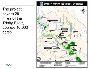
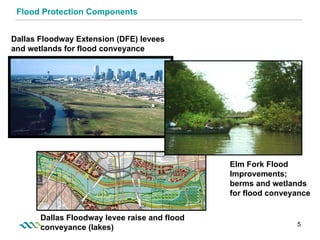
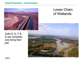
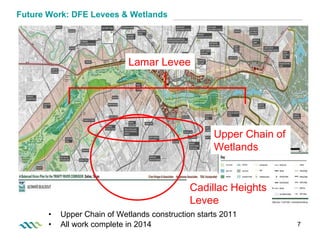
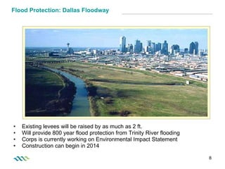
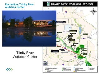
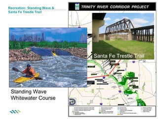
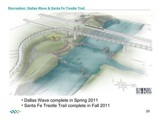
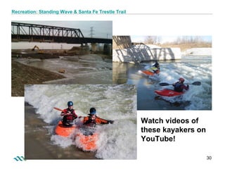
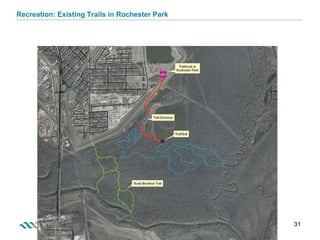
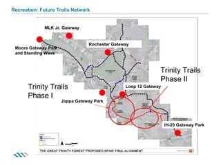
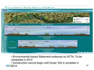
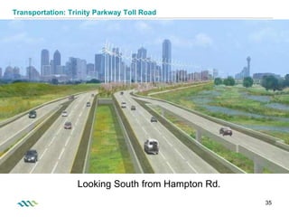
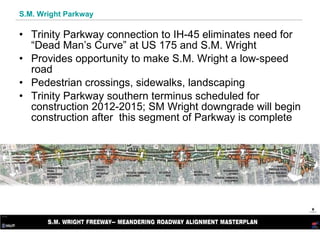
The Trinity River Corridor Project covers 20 miles of the Trinity River and 10,000 acres, with the primary objective of flood protection. It also aims to improve environmental restoration, recreation, transportation, and community/economic development. Major components include constructing levees, wetlands, and interior drainage systems to protect against 100-year and 800-year floods. Many recreation components are also underway like trails, parks, and an urban lake. The transportation plan includes the Trinity Parkway toll road and upgrades to S.M. Wright Parkway.
The document discusses the Trinity River Corridor Project which covers 20 miles of the Trinity River and 10,000 acres. The project has multiple objectives including flood protection, environmental restoration, recreation, transportation, and economic development. Flood protection remains the essential component and involves levee construction, wetland creation, and raising levees to provide 800-year flood protection. The project also involves restoring thousands of acres of forest habitat, and creating a extensive trail and park system along the Trinity River featuring lakes, wetlands, and other recreational amenities.
The Southern Delivery System (SDS) is a 50-mile pipeline project in Colorado that will provide water from the Arkansas River to Colorado Springs and other communities. Construction of the pipeline involved overcoming geological and logistical challenges, including tunneling under a railroad and allowing ATV access during construction through designated crossings. Community engagement efforts like ongoing resident communication helped mitigate disruption from the 6.4-mile section that passed through 125 residential yards. The project is expected to come in under its nearly $1 billion budget due to contracting the pipeline in sections to encourage competitive bidding.
1) A micro-NGO called "If Pigs Could Fly - Helping Hillside Haiti" established a solar-powered water pumping system in the remote village of Mon Bouton in rural Haiti to bring water closer to homes.
2) The system uses solar panels to power pumps that lift water through pipes from a reservoir 700 meters downhill, to storage tanks at intermediate and upper elevation sites.
3) The system provides around 300 gallons of water per day to the community, saving women and children from carrying water long distances. It demonstrates how appropriate technology can sustainably improve living conditions in developing areas.
Highway 40 in Alberta was severely damaged by 2013 floods, with over 100 locations along a 55km stretch requiring repairs. The highway provides access to Kananaskis Country and is the highest paved road in Canada. Associated Engineering was tasked with repairing the highway in under 5 months while minimizing environmental impacts. They developed innovative solutions like an environmental monitoring database tool and expedited regulatory approvals. The highway was reopened ahead of schedule in September 2013, restoring access to the area.
The SFPUC will begin construction in June 2009 on a project to install three new pipeline crossovers along Bay Division Pipelines 3 and 4. The crossovers will allow the SFPUC to isolate sections of the pipelines for maintenance or repairs and to move water between pipelines in emergencies like earthquakes. The project is part of a larger $4.4 billion program to seismically upgrade the water delivery system, which serves 2.5 million people in the Bay Area. Construction of the first crossover will take place at the Guadalupe River site in Santa Clara's Ulistac Natural Area.
Glassy Creek Restoration Project_Urban Restoration Projects_2014 NCAFPM Prese...Danee McGee
The Glassy Creek Restoration Project aimed to address severe erosion, improve water quality, and create fish and insect habitat in an urban stream. It faced challenges including a small downstream channel, constraints from utilities and school properties, and contaminated soil removal. Careful planning and coordination with stakeholders helped overcome these challenges to create a stable, meandering stream providing aquatic habitat while meeting regulatory water quality goals. Lessons learned can help improve future urban stream restoration projects.
Jason Abendroth has extensive experience in structural engineering projects related to flood protection, water control, transportation, and bridge inspection. Some of his key projects include feasibility studies and designs for flood control structures, levees, pumping stations, and bridges in New York, Louisiana, and other locations impacted by hurricanes and flooding. He has specialized in designing concrete and steel structures such as gates, walls, and foundations to mitigate flood risk.
The city is conducting a study of the Lawrence Park neighbourhood to address infrastructure problems like deteriorated roads, pedestrian safety issues, poor traffic management, and basement flooding. The study involves assessing the current conditions, getting public input, developing a master plan to address the issues, and undertaking detailed engineering design and construction. Key issues identified include the need to reconstruct aging roads, improve sidewalks and pedestrian connections, enhance traffic safety, upgrade storm and sanitary sewer systems, and address flooding complaints. The process will aim to balance infrastructure upgrades with minimizing tree loss and maintaining neighbourhood character.
Jason Abendroth is a structural/civil engineer with over 10 years of experience in the design and inspection of various structures including flood control infrastructure, bridges, and lift stations. He has expertise in structural design, inspection, project management, and geotechnical analysis. He is proficient in various engineering software and received a BS in Civil Engineering from Louisiana State University.
Miller Heights Outfall Rehabilitation Project 2014Fairfax County
The Miller Heights Outfall Rehabilitation Project was completed on time and within budget. The project involved stabilizing over 250 feet of eroded channel near Miller Road and Miller Heights Road. Natural stream channel design was used, including rock cross vanes, weirs, and plantings to reduce erosion and improve water quality. The project addressed safety concerns and stabilized the channel while providing environmental benefits.
Presentation to Melbourne Emergence Meetup December 2017 adding detail to original presentation made in February. Slide text served as prompts to deeper discussion. Two slides added at end for context that wasn't needed for live audience.
Flatlick Branch - Phase 1 Stream RestorationFairfax County
The Flatlick Branch - Phase I Stream Restoration project involved restoring over 1,850 linear feet of stream and tributaries. It upgraded an existing stormwater basin to a constructed wetland, replaced a failed stream crossing, and sewer main. Native plants were installed, and the project provides pollutant removal and water quality benefits. Substantially completed in December 2016, it was a partnership between Fairfax County agencies and the Park Authority.
Fairfax County Land Conservation Awards 2016Fairfax County
This document provides information about the Fairfax County Land Conservation Awards 2016 event. It recognizes outstanding projects, individuals, and organizations in several categories related to land conservation and environmental protection efforts in Fairfax County, Virginia. The categories include large single family residential, large commercial, small commercial, special project, and infill lot. Several projects are highlighted for each category, and individuals are recognized for their contributions in engineering, construction oversight, development, and conservation work.
The Dolphin Lane Sewer Sag Project in Fairfax County, VA installed approximately 115 feet of new 8-inch ductile iron pipe to replace an existing sanitary sewer line containing a 9-inch sag. The project team installed two standard manholes, one dog house manhole, replaced a lateral, and added non-shrink grout to an abandoned line. The project was substantially completed on November 28, 2016 to upgrade the sewer system on Dolphin Lane.
Quander Road Outfall and Stream RestorationFairfax County
The Quander Road Stream Restoration project restored approximately 775 linear feet of a highly eroded storm drainage channel and 225 linear feet of an associated tributary using natural channel design techniques. This included installing structures like boulder pools, step pools, and rock sills to prevent future erosion and planting native vegetation to improve water quality. The project reduced nitrogen by over 3,000 pounds per year, phosphorus by over 1,300 pounds per year, and suspended solids by over 230 tons per year. Before the project, the stream banks were very steep and highly eroded, and the restoration efforts reconnected the channel to the floodplain and re-established natural flow dynamics.
Civil Engineering Technical Project for an existing T intersection needing to be updated. Plans submitted to NCDOT, City of Asheville, and to Wilbur Smith Engineering company over the Wilma Dykeman Riverway Project in Asheville North Carolina. This was submitted by the Senior Project Class Spring 2011
The Wakefield Park South Stream Restoration project in Fairfax County, VA was completed ahead of schedule and on budget. The project restored 2,700 linear feet of streams that feed into Accotink Creek using natural channel design techniques. This included establishing stable channels and floodplains, installing structures to reduce erosion and improve habitat, and reducing nitrogen, phosphorus, and sediment runoff into Accotink Creek. The project was a collaboration between Fairfax County agencies and private contractors.
The Huntington Levee is located at 5755 Mt. Vernon Drive, Alexandria, and provides a 2,800-foot levee along Cameron Run to protect the community from flooding associated with storms of up to at least a 100-year event. The levee is made up of a 10- to 15-foot high earthen embankment with a 4-foot high concrete I-wall which caps the steel sheet piles embedded in the embankment. The project also includes a 5,300 square foot mechanical pump station that houses three 42.5 million gallon per day axial flow pumps for the larger storm events and three 8,000 gallon per minute low flow pumps for base flows and smaller storms. Upgrades to the Farrington Park playground and a network of connecting trails was included in the project. The new levee infrastructure has been operational since spring 2019 and recently provided flood protection for the adjacent homes and community during the major rainfall event of July 8, 2019.
The project achieved the Institute for Sustainable Infrastructure Envision Bronze Award and has been recognized with the National Capital Section of the American Society of Civil Engineers Sustainable Project/Program of the Year Award for 2019.
Cynefin meets the Maribyrnong and Moonee Ponds CreekTony Smith
Presentation to Melbourne Emergence Meetup of a mid-course reflection on the progress of Melbourne Water's Health Waterways Refresh Catchment Collaborations. The process has drawn on Dave Snowden's Cynefin framing via Twyfords.
VDOT: Fairfax County Board of Supervisors Transportation Committee: Dec. 13, ...Fairfax County
Virginia was selected to receive a $165 million federal grant to improve more than 50 miles of the I-95/I-395 corridor from Fredericksburg to the Pentagon. The improvements include extending I-95/I-395 express lanes north and south, improving commuter rail service, constructing additional rail tracks, and increasing the capacity of general purpose lanes. Public comments expressed both support and opposition for aspects of the project such as new noise walls and toll rates.
In response to traffic congestion on St Clair Avenue West around Keele Street and Old Weston Road, City Council has directed staff to carry out an Environmental Assessment (EA) Study of the St. Clair Avenue / Rail Crossing between Keele Street and Old Weston Road. This project will investigate solutions to the traffic concerns in this area
The document discusses dams and hydraulic structures. It provides an overview of different types of dams including embankment, gravity, buttress, and arch dams. It emphasizes the importance of regular inspections and monitoring of dams to identify any signs of distress or changes in conditions. The document also discusses causes of dam failures, noting that embankment dams and older dams are more likely to fail than other types. Embankment dams from 1900 had around a 10% probability of failure while modern dams constructed after 1950 have less than a 0.04% chance.
The document proposes the Merrimack Riverwalk Project conceived by Professor Donald Leitch. It summarizes the current conditions of areas along the Merrimack River near UMass Lowell, including an observation deck, walking paths, and Beaver Brook Bridge. The project envisions improving safety and accessibility by rehabilitating the observation deck, creating a new multi-use path and pedestrian bridge, and better connecting existing pathways into a continuous loop along the river. The proposed walkway would benefit the environment, community, and students while promoting health and recreation.
Răzvan Voicu - Measures of ecological reconstruction of Baseul Vechi and Base...Răzvan Voicu
This document discusses proposals for ecologically restoring the Baseu Vechi and Baseu Rivers in Romania. It was channeled during the communist regime, negatively impacting the ecosystem. The document evaluates two ecotechnical methods for partially diverting the Baseu River flow into the old riverbed of the Baseu Vechi River in order to restore its ecological functions. Method I involves building two connecting ponds, while Method II uses a pipeline directly from the river. Both aim to supply water to revive the Baseu Vechi River ecosystem and create a wetland area. Bank stabilization and planting are also proposed to restore riparian areas.
This document is a resume for Kenneth Blankenship that summarizes his education, licenses, skills, work experience and major projects. Blankenship has over 30 years of experience in underground utilities, site development and construction project management. He is the president of his own contracting company and has managed large public works projects for state, county and city governments totaling over $50 million and involving utilities, roads, bridges and sewer/water infrastructure.
2018 Engineering Excellence Diamond Project PanelsACEC New York
This document lists various engineering firms that received Diamond Awards and Empire Awards for notable infrastructure projects in New York. It provides the names of 18 engineering firms, the municipalities or organizations they worked with, and brief descriptions of projects related to transportation, buildings, water and wastewater systems, and more.
This public event presented design concepts for the preferred trail alignment of the East Don Trail project. Attendees could view panels and presentations about the design concepts and provide feedback. The design concepts were developed by dividing the preferred alignment into segments and considering constraints like topography, trees, and infrastructure. Options were evaluated based on criteria such as environmental impacts, safety, accessibility, and costs. Feedback from the event will be used to select a preliminary preferred design concept.
The Lower Don Trail is a 4.7 kilometre section of multi-use trail for pedestrians and cyclists that runs along the Don River, from Pottery Road to Corktown Commons.
This project includes a number of works to improve the conditions of the existing trail and access into the surrounding trail network.
Construction is starting September 2015. Learn more here and at www.toronto.ca/lowerdontrail
The document discusses revitalization of rivers in the United States through dam removal. It provides background on the benefits and impacts of dams, and the history of dam construction and removal in the US. Over 750 dams have been removed, mostly small dams, to help restore rivers and ecosystems. Case studies are presented on dam removals on the Chiloquin River in Oregon, Rogue River in Oregon, and Elwha River in Washington to restore fish passage and ecosystems while managing sediment impacts.
The document discusses revitalization of rivers in the United States through dam removal. It provides background on the impacts of dams, history of dam construction and removal in the US. Specifically, it examines case studies of dam removals on the Chiloquin River in Oregon, Rogue River in Oregon, and Elwha River in Washington. For the Elwha River dams, the reservoirs contained major sediment problems that required concurrent dam removal and management of reservoir sediments to minimize downstream impacts.
Colorado Springs has a long history of planning for its water needs dating back to the 1870s. As the city grew further from water sources like Fountain Creek, it developed an extensive water collection and delivery system involving numerous reservoirs, pipelines, and transmountain diversion projects. The Southern Delivery System (SDS) was identified in Colorado Springs' 1996 Water Resource Plan as the major new delivery system needed to meet 55% of the city's future water demands, as existing systems were nearing capacity. SDS will be a regional project to transport water from Pueblo Reservoir through 62 miles of pipeline to Colorado Springs and partner communities. Phase I is currently under construction at an estimated cost of $880 million to be completed by 2016.
Fairfax county roadway rehabilitation projectsFairfax County
The Fairfax County Department of Public Works and Environmental Services rehabilitated 13 county roadways in 2017. The projects involved milling and paving surfaces, base improvements, sidewalk and curb repairs, and ADA upgrades. The roads are in the Lee, Mason, Mount Vernon, Providence, and Springfield districts. Project locations included service drives along major roads and residential streets. Before and after photos show the improved conditions of paved surfaces and infrastructure after rehabilitation.
The document provides an executive summary of the Calumet-Sag Channel Detailed Watershed Plan. It summarizes the watershed plan's scope, an overview of the Calumet-Sag Channel watershed, an evaluation of existing flooding and erosion conditions, an evaluation of alternative stormwater improvement projects, and recommendations. Key findings include that Stony Creek and its tributaries account for 61% of existing damages, recommended projects could address 45% of Stony Creek damages, and alternatives were identified to reduce expected flooding damages throughout the watershed.
This document provides an overview and status update of the DC Clean Rivers Project being undertaken by the District of Columbia Water and Sewer Authority. Key points:
- The project involves constructing tunnels, storage tanks, and other infrastructure to control combined sewer overflows and reduce flooding. Over $3.5 billion is being invested with completion expected by 2030.
- To date, over 96% of CSOs have been eliminated in the Anacostia and Potomac Rivers, and several tunnels and other facilities have been constructed.
- Additional benefits once complete will include eliminating 98% of CSOs in the Anacostia, reducing nitrogen discharge, and relieving flooding throughout DC.
This document provides details about a pond retrofit project in Fairfax County, VA called Towlston Meadows Sec 3 Pond 1. The purpose of the project was to increase water quality and add an access road for maintenance. Work included regrading the pond, adding micro pools, increasing storage volume, and constructing an all-weather access road. Native plants were also installed to restore the landscape. The project was completed on time and on budget in April 2014.
The document summarizes a public meeting about upcoming sewer improvement projects in the River Road area. It discusses the need to eliminate sanitary sewer overflows by 2006 to avoid penalties. It outlines plans to build an underground equalization basin and pump stations, install new force main and relief sewers, and replace a water line on River Road. Construction will start in the next few weeks and be completed by fall 2006. The projects will require temporary traffic disruptions and loss of the baseball diamond at River Road Park for two seasons. Another meeting will be scheduled to address resident questions and concerns.
This document summarizes the challenges faced by the town of Buckland, Massachusetts after Tropical Storm Irene in 2011. It discusses how Irene caused widespread infrastructure damage, cutting off residents and roads. Buckland had limited resources and staff to address the estimated $6.2-$30 million in repairs needed. The town worked quickly to make temporary repairs and open roads while pursuing funding from FEMA, MEMA and other agencies for permanent solutions. A steering committee was also formed to help local officials in the Deerfield River watershed plan for and fund more resilient infrastructure improvements to reduce damage from future storms.
The Steelhead Haven Landslide Fine Sediment Reduction Project aimed to reduce fine sediment inputs into the Stillaguamish River from a landslide, which was a major factor in the decline of Chinook salmon populations to 8% of historic levels. The project involved constructing a 1,300 foot long, 25 foot high log cribwall with ballast blocks to stabilize the landslide and store sediment, improving habitat for over 30 river miles. Initial designs were impacted when the landslide failed before construction in 2006. The final design was more engineered to withstand river forces and allow for channel migration over time while maintaining sediment storage and stabilization of the landslide.
The document summarizes a project to enhance habitat at the 45 Ranch located on the South Fork of the Owyhee River in Idaho. The goals of the project were to improve public land access and restore the river and floodplains by reconfiguring abandoned river channels and repairing infrastructure. This included optimizing the ranch's water rights, eliminating a diesel pump, improving roads, and raising river elevations to increase wetlands and habitat for fish and wildlife. The project was a partnership between the ranch owners, The Nature Conservancy, the Bureau of Land Management, and others. Phase 1 of construction was completed in 2008 and included building a new irrigation diversion, repairing roads, and constructing habitat berms and wetlands.
This document summarizes the Downtown Guadalupe River Project, which aims to provide 100-year flood protection for a 170 square mile watershed in Sacramento. It discusses the project's history and authorization, pre-project flood risks, the collaborative planning process, project features including bypass culverts and habitat restoration, construction challenges in an urban area, and environmental considerations like protecting fish habitat. The project is being implemented in phases, with photos showing progress on contracts 3A, 3B and 3C that include bypass culverts and river restoration.
The document summarizes a public meeting about sewer improvements in Point Place, Toledo. It discusses the overall Toledo Waterways Initiative to upgrade the city's sewer system to avoid penalties from the EPA. It then provides details on Phases 2B and 2C of the Point Place project, including the planned construction areas, timelines, and traffic plans to minimize disruption during school hours and evenings. Residents are encouraged to provide any additional questions or comments.
Colvin Run Phase I Lake Fairfax Park Stream Restoration ProjectFairfax County
The Colvin Run Phase I Lake Fairfax Park Stream Restoration Project restored 2,220 feet of Colvin Run Branch in Fairfax County, VA through natural channel design. This included improving stream morphology, reducing erosion, re-aligning the stream, creating wetlands, replacing a culvert, and landscaping with native plants. The project team included various Fairfax County departments and was completed in August 2017. It is estimated to reduce pollution in the stream annually.
Doan Brook Parks explores park landscape in the hand of natural and human forces. Find evidence for the rise of local bedrock, for bulldozing glacial ice and for Doan Brook’s cutting of a beloved ravine.Review the impacts of park development, including the outstanding Cleveland Cultural Gardens. See the recently completed Doan Brook Enhancement Project in terms of stormwater mediation and the restoration of local natural habitats.
Citizens Vision - Cleveland OH Scranton Peninsula River JewelR Ray Saikus
Proposal for a channel along the Cuyahoga River in Cleveland Ohio at the base of the Scranton Peninsula to improve commercial navigation and free up 1 mile of river for continuous public use and more public access time all along the length of the river. An infrastructure shovel ready project with many short and long term benefits for Cleveland and the region. Reduced dredging benefits the environment.
The document provides an overview of the Truckee Meadows Nevada Flood Project which aims to reduce flood risk along 54 miles of the Truckee River in Nevada. It discusses the history of flooding in the Reno/Sparks area, the elements of the project including levees and ecosystem restoration, and the status and funding for the project. It compares the proposed National Economic Development Plan to the locally preferred plan and outlines some early construction and restoration sites as well as planned tasks for fiscal years 2009-2010.
The document summarizes a traffic flow improvement project in Bird Rock that included installing several roundabouts and traffic circles at intersections to reduce speeds and improve traffic flow. It describes the planning and design process, including community involvement, addressing design challenges like right of way impacts, and ensuring large vehicles could safely navigate the new intersections. Lessons learned included the need for proper turning templates, in-pavement flashers to assist pedestrians, and maintaining visibility at landscaped areas.
The document provides an update on River Road Area Sewer Improvement projects including:
1) Loans totaling $34 million were taken out this year and $110 million will be borrowed next year to fund the projects at extremely favorable terms.
2) An underground equalization basin and pump station will be constructed at River Road Park to store and pump sewage with completion targeted for November 2006.
3) New relief sewers and a force main sewer will be installed along River Road and Beverly to alleviate basement flooding and eliminate sanitary sewer overflows in the area.
Similar to Trinity River Corridor Project 2011 (20)
How to Manage Your Lost Opportunities in Odoo 17 CRMCeline George
Odoo 17 CRM allows us to track why we lose sales opportunities with "Lost Reasons." This helps analyze our sales process and identify areas for improvement. Here's how to configure lost reasons in Odoo 17 CRM
How to Fix the Import Error in the Odoo 17Celine George
An import error occurs when a program fails to import a module or library, disrupting its execution. In languages like Python, this issue arises when the specified module cannot be found or accessed, hindering the program's functionality. Resolving import errors is crucial for maintaining smooth software operation and uninterrupted development processes.
LAND USE LAND COVER AND NDVI OF MIRZAPUR DISTRICT, UPRAHUL
This Dissertation explores the particular circumstances of Mirzapur, a region located in the
core of India. Mirzapur, with its varied terrains and abundant biodiversity, offers an optimal
environment for investigating the changes in vegetation cover dynamics. Our study utilizes
advanced technologies such as GIS (Geographic Information Systems) and Remote sensing to
analyze the transformations that have taken place over the course of a decade.
The complex relationship between human activities and the environment has been the focus
of extensive research and worry. As the global community grapples with swift urbanization,
population expansion, and economic progress, the effects on natural ecosystems are becoming
more evident. A crucial element of this impact is the alteration of vegetation cover, which plays a
significant role in maintaining the ecological equilibrium of our planet.Land serves as the foundation for all human activities and provides the necessary materials for
these activities. As the most crucial natural resource, its utilization by humans results in different
'Land uses,' which are determined by both human activities and the physical characteristics of the
land.
The utilization of land is impacted by human needs and environmental factors. In countries
like India, rapid population growth and the emphasis on extensive resource exploitation can lead
to significant land degradation, adversely affecting the region's land cover.
Therefore, human intervention has significantly influenced land use patterns over many
centuries, evolving its structure over time and space. In the present era, these changes have
accelerated due to factors such as agriculture and urbanization. Information regarding land use and
cover is essential for various planning and management tasks related to the Earth's surface,
providing crucial environmental data for scientific, resource management, policy purposes, and
diverse human activities.
Accurate understanding of land use and cover is imperative for the development planning
of any area. Consequently, a wide range of professionals, including earth system scientists, land
and water managers, and urban planners, are interested in obtaining data on land use and cover
changes, conversion trends, and other related patterns. The spatial dimensions of land use and
cover support policymakers and scientists in making well-informed decisions, as alterations in
these patterns indicate shifts in economic and social conditions. Monitoring such changes with the
help of Advanced technologies like Remote Sensing and Geographic Information Systems is
crucial for coordinated efforts across different administrative levels. Advanced technologies like
Remote Sensing and Geographic Information Systems
9
Changes in vegetation cover refer to variations in the distribution, composition, and overall
structure of plant communities across different temporal and spatial scales. These changes can
occur natural.
This presentation was provided by Steph Pollock of The American Psychological Association’s Journals Program, and Damita Snow, of The American Society of Civil Engineers (ASCE), for the initial session of NISO's 2024 Training Series "DEIA in the Scholarly Landscape." Session One: 'Setting Expectations: a DEIA Primer,' was held June 6, 2024.
Walmart Business+ and Spark Good for Nonprofits.pdfTechSoup
"Learn about all the ways Walmart supports nonprofit organizations.
You will hear from Liz Willett, the Head of Nonprofits, and hear about what Walmart is doing to help nonprofits, including Walmart Business and Spark Good. Walmart Business+ is a new offer for nonprofits that offers discounts and also streamlines nonprofits order and expense tracking, saving time and money.
The webinar may also give some examples on how nonprofits can best leverage Walmart Business+.
The event will cover the following::
Walmart Business + (https://business.walmart.com/plus) is a new shopping experience for nonprofits, schools, and local business customers that connects an exclusive online shopping experience to stores. Benefits include free delivery and shipping, a 'Spend Analytics” feature, special discounts, deals and tax-exempt shopping.
Special TechSoup offer for a free 180 days membership, and up to $150 in discounts on eligible orders.
Spark Good (walmart.com/sparkgood) is a charitable platform that enables nonprofits to receive donations directly from customers and associates.
Answers about how you can do more with Walmart!"
Exploiting Artificial Intelligence for Empowering Researchers and Faculty, In...Dr. Vinod Kumar Kanvaria
Exploiting Artificial Intelligence for Empowering Researchers and Faculty,
International FDP on Fundamentals of Research in Social Sciences
at Integral University, Lucknow, 06.06.2024
By Dr. Vinod Kumar Kanvaria
ISO/IEC 27001, ISO/IEC 42001, and GDPR: Best Practices for Implementation and...PECB
Denis is a dynamic and results-driven Chief Information Officer (CIO) with a distinguished career spanning information systems analysis and technical project management. With a proven track record of spearheading the design and delivery of cutting-edge Information Management solutions, he has consistently elevated business operations, streamlined reporting functions, and maximized process efficiency.
Certified as an ISO/IEC 27001: Information Security Management Systems (ISMS) Lead Implementer, Data Protection Officer, and Cyber Risks Analyst, Denis brings a heightened focus on data security, privacy, and cyber resilience to every endeavor.
His expertise extends across a diverse spectrum of reporting, database, and web development applications, underpinned by an exceptional grasp of data storage and virtualization technologies. His proficiency in application testing, database administration, and data cleansing ensures seamless execution of complex projects.
What sets Denis apart is his comprehensive understanding of Business and Systems Analysis technologies, honed through involvement in all phases of the Software Development Lifecycle (SDLC). From meticulous requirements gathering to precise analysis, innovative design, rigorous development, thorough testing, and successful implementation, he has consistently delivered exceptional results.
Throughout his career, he has taken on multifaceted roles, from leading technical project management teams to owning solutions that drive operational excellence. His conscientious and proactive approach is unwavering, whether he is working independently or collaboratively within a team. His ability to connect with colleagues on a personal level underscores his commitment to fostering a harmonious and productive workplace environment.
Date: May 29, 2024
Tags: Information Security, ISO/IEC 27001, ISO/IEC 42001, Artificial Intelligence, GDPR
-------------------------------------------------------------------------------
Find out more about ISO training and certification services
Training: ISO/IEC 27001 Information Security Management System - EN | PECB
ISO/IEC 42001 Artificial Intelligence Management System - EN | PECB
General Data Protection Regulation (GDPR) - Training Courses - EN | PECB
Webinars: https://pecb.com/webinars
Article: https://pecb.com/article
-------------------------------------------------------------------------------
For more information about PECB:
Website: https://pecb.com/
LinkedIn: https://www.linkedin.com/company/pecb/
Facebook: https://www.facebook.com/PECBInternational/
Slideshare: http://www.slideshare.net/PECBCERTIFICATION
বাংলাদেশের অর্থনৈতিক সমীক্ষা ২০২৪ [Bangladesh Economic Review 2024 Bangla.pdf] কম্পিউটার , ট্যাব ও স্মার্ট ফোন ভার্সন সহ সম্পূর্ণ বাংলা ই-বুক বা pdf বই " সুচিপত্র ...বুকমার্ক মেনু 🔖 ও হাইপার লিংক মেনু 📝👆 যুক্ত ..
আমাদের সবার জন্য খুব খুব গুরুত্বপূর্ণ একটি বই ..বিসিএস, ব্যাংক, ইউনিভার্সিটি ভর্তি ও যে কোন প্রতিযোগিতা মূলক পরীক্ষার জন্য এর খুব ইম্পরট্যান্ট একটি বিষয় ...তাছাড়া বাংলাদেশের সাম্প্রতিক যে কোন ডাটা বা তথ্য এই বইতে পাবেন ...
তাই একজন নাগরিক হিসাবে এই তথ্য গুলো আপনার জানা প্রয়োজন ...।
বিসিএস ও ব্যাংক এর লিখিত পরীক্ষা ...+এছাড়া মাধ্যমিক ও উচ্চমাধ্যমিকের স্টুডেন্টদের জন্য অনেক কাজে আসবে ...
The simplified electron and muon model, Oscillating Spacetime: The Foundation...RitikBhardwaj56
Discover the Simplified Electron and Muon Model: A New Wave-Based Approach to Understanding Particles delves into a groundbreaking theory that presents electrons and muons as rotating soliton waves within oscillating spacetime. Geared towards students, researchers, and science buffs, this book breaks down complex ideas into simple explanations. It covers topics such as electron waves, temporal dynamics, and the implications of this model on particle physics. With clear illustrations and easy-to-follow explanations, readers will gain a new outlook on the universe's fundamental nature.
How to Make a Field Mandatory in Odoo 17Celine George
In Odoo, making a field required can be done through both Python code and XML views. When you set the required attribute to True in Python code, it makes the field required across all views where it's used. Conversely, when you set the required attribute in XML views, it makes the field required only in the context of that particular view.
Executive Directors Chat Leveraging AI for Diversity, Equity, and InclusionTechSoup
Let’s explore the intersection of technology and equity in the final session of our DEI series. Discover how AI tools, like ChatGPT, can be used to support and enhance your nonprofit's DEI initiatives. Participants will gain insights into practical AI applications and get tips for leveraging technology to advance their DEI goals.
5. Flood Protection Components Elm Fork Flood Improvements; berms and wetlands for flood conveyance Dallas Floodway Extension (DFE) levees and wetlands for flood conveyance Dallas Floodway levee raise and flood conveyance (lakes)
6. Flood Protection - Construction Lower Chain of Wetlands Cells D, E, F & G are complete, and doing their job!
7.
8.
9. Levee Section at Commerce Water Surface Elevations vs Parkway Existing Levee Elevation 429.40 Future 2-Foot Raised Levee Elevation 431.40 Ground Elevation about 400.00 Average low flow conditions that stay within the river channel of the Dallas Floodway Elevation 382.00 800-year Flood Elevation 428.97 100-year Elevation 417.06 Same as 1908 flood of record May 1990 35-year Flood Elevation 415.24 June 2007 5-year Flood Elevation 408.38 Trinity Parkway Flood Protected Elevation 419.06
10. Dallas Floodway System Components Dry Side Sump Interior Drainage refers to the system of sump & pump stations – note that both dry sides of levees have interior drainage and vegetation free zones Pump Station Levee Toe of Levee River Channel Levee Slope 15’ Vegetation Free Zone Trinity River
32. Recreation: Future Trails Network Trinity Trails Phase I Trinity Trails Phase II Moore Gateway Park and Standing Wave IH-20 Gateway Park Rochester Gateway MLK Jr. Gateway Loop 12 Gateway Joppa Gateway Park
42. Transportation: Margaret Hunt Hill Bridge Visit the webcam at www.trinityrivercorridor.org to view construction progress Margaret Hunt Hill Bridge under construction complete in 2011
20 mile stretch of the Trinity River From Royal Lane, along the Elm Fork, through downtown, down to Interstate 20 10,000 acres, one of the largest urban parks in the country Compare to other “famous” urban park…Central Park is 840 acres
Flood Protection Strengthen our levees Raise our levees Extend our levees (through Dallas Floodway Extension) Wetland Cells for better floodwater conveyance Dallas Floodway Extension, working with the Corps of Engineers, the DFE project: Extends existing levees 5-1/2 miles to protect Cadillac Heights and Lamar Neighborhoods Provides 3-1/2 miles of wetlands for flood conveyance (restores downtown flood protection to 800 year, increases flood protection for wastewater plant from 140 year to 500 year) Wetlands also provide wildlife habitat This work is already underway!! Elm Fork Flood Improvements Interior drainage improvements (sumps), wetlands, a smaller 100 year flood protection berm to protect this largely industrial area Dallas Floodway Also being done with Corps of Engineers Besides recreation, lakes provide flood conveyance Levees will be raised 2 ft. to provide additional “buffer” above 800 year flood protection
Lower Chain of Wetlands is already complete, and has reduced flood levels upstream by about 1 ft. The purpose of the chain of wetlands is to provide flood conveyance through the Great Trinity Forest. When the Trinity River floods, it does not flow very fast through the forest because of the density of the trees. We are creating open space for the floodwaters to flow, thereby reducing flood levels upstream. There will be 7 wetland cells in all, ranging from 10 acres to 20 acres each, shallow on the edges and deeper in the middle. These wetlands cells also provide wildlife habitat. Waterfowl like herons and egrets, turtles, beaver and other forest animals like to come to the wetlands for food and water. Flood levels upstream are estimated to be lowered by as much as 1 foot due to excavation that has taken place The upper chain of wetlands could begin construction this year, and will extend from IH-45 upwards to the DART bridge crossing of the Trinity River.
NOTE: IDENTIFIERS POP UP ON MOUSE CLICK The future flood protection work includes 800 year flood protection for Lamar and Cadillac Heights and the upper chain of wetlands
The Dallas Floodway project includes both the recreational features of the Balanced Vision Plan, along with the raising of our existing levees to provide additional protection from the 800 year flood event.
Levees were originally built in the 1920’s and raised to their current height in 1960’s 26 mile system, levees are on average 30 ft. tall Back in June 2007, we had about a 5-year flood event, water reached about 8 ft. on the levees Largest flood Dallas has ever experienced, since the levees were built, was in 1990. Approximately 35-40 year flood event, got about halfway up on the levees Flood of Record, largest flood event in Dallas (before the levees), occurred in 1908. It was a 100-year levee event (which has a 1% change of occurrin in any given year). Levees will be raised and fattened to provide protection from the Standard Project Flood, which is the 800 year flood event in this area (has a 0.125% chance of occurring in any given year)
Rain is animated for a brief period. Visual description of the floodway system The pumps and sumps move water from the dry side of the levees to the river Additional improvements on Pump Stations and Sumps are necessary – we anticipate additional flood protection bond propositions in 2012
Flooding outside the levees occurs when our stormwater sumps and pump stations do not have enough capacity to either store the stormwater in the sump areas, or pump the stormwater through the levees into the Trinity River From the 2006 Bond Program, approximately $171 million was allocated to improving our stormwater sumps and pump stations
Note: animated slide. Baker and Pavaho will pop up first. Pavaho Pump Station is under construction, and will be complete in Summer 2012. Baker Pump Station should begin construction later this year. Able and Charlie pop up next, then Hampton and Trinity Portland. These designs have just begun (are at 35% design level). Construction funds will be needed from the 2012 bond program.
Next slides will take you geographically down the Trinity River, from the confluence of the Elm and West Fork down to the DART bridge
Note: Animated slide! Graphic comes up on mouse click. Soccer complex under design now; should begin construction of Phase 1 (11 ball fields, parking, concessions, restrooms, irrigation, lighting) this year Phase 2 will include an additional 11 fields, trails and other park amenities
Click once to move to the left side of this slide. Click again to zoom in. Point out features of interest. Click a second time to move to the right side of this slide. Again, point out features. Water for the Urban and Natural Lakes will be provided from the Central Wastewater Treatment Plant effluent. It will flow counter to the Trinity River flow, creating the opportunity for a 4 mile canoe loop (Natural Lake, to Urban Lake, to Trinity River, back down to Natural Lake)
Note: Animated slide. Starts out with existing view under Westmoreland -West Dallas Lake is 120 acres and 2,000 meters long, which will enable us to host competitive rowing (or crew) competitions. The lake will also be available for casual boating. -Submerged wetlands will act as lane markers
An amphitheater will be located on the north side of the West Dallas Lake for concerts, rowing competition viewing and other venues
West Dallas Ball Fields
Shade structures will be illuminated at night Potential concession opportunity for a water taxi to provide transportation to various points on the lake Center Island (separating the river from the lake) will provide 2 year flood protection for the lake. On average, every 2 years, the river will get high enough to inundate the lakes. When that happens, we will let the waters recede, wash down and clean up any areas, then resume operations. During dry periods, tent festivals or rubber-tired concessions could be in the floodplain without danger of flooding.
A place where visitors can sit on the levee and watch the project be constructed over the next 4-5 years. Located at Beckley & Commerce on the levee. Funded in part by a grant from Metlife Foundation, through the Trust for Public Land.
Animated slide: floodplain transforms into scene of boardwalk and pedestrians Boardwalks across the wetlands will allow visitors to get closer to the wildlife and their habitat
Next slides will take you geographically down the Trinity River, from the confluence of the Elm and West Fork down to the DART bridge
City is partnering with the National Audubon Society to build their “flagship” facility in this area. 20,000 sq. ft. facility Located on 120 acres, off loop 12, east of IH-45 Designed by Antoine Predock
Will be eligible for Gold LEED certification “ green” features include a grass roof, insulation made out of shredded blue jeans, use of ambient light, rainwater collection system, solar energy
Note: Animated slide! Standing Wave and Santa Fe Trestle Trail each come up on mouse click Standing Wave – under construction, to be opening in Spring 2011 Santa Fe Trestle Trail – under construction, to be opening in October 2011 Center trestle will remain and be restored to accommodate pedestrian and bicycle traffic Wooden pilings will be torn down and replaced with ramps going up to the trestle
Two whitewater areas will be constructed, but will have a bypass channel for a more gentle ride Trail and access road to parking lot will connect back to Moore Park
Student conservation Association created 8 miles of soft surface trails in the Great Trinity Forest (blue line). We added an ADA-accessible hard surface trail to the Texas Buckeye Trail (green line) Trailhead and trail over the levee has been awarded for construction (red line)
Note: Animated slide – phase I comes up first, then phase II, then gateway parks on mouse clicks Trinity Trails Phase I is nearing completion. It extends 1.7 miles from Loop 12 (near Joppa) down to Simpson Stuart. Trinity Trails Phase II is under construction. It will extend from Simpson Stuart across the Trinity River and into the Trinity River Audubon Center. Future phases are shown in black, river crossings are in blue. Gateway parks are in various stages of master planning, design and construction
Trinity Parkway 8.5 mile roadway, extending from 183 in the north to 175 in the south Reliever route will carry 100,000 vehicle trips per day Context sensitive design, due to its proximity to the park. It is being designed to blend in, not have visual intrusion or excessive noise Road will be built at an elevation above the 100 year flood in some areas; in other areas where it must dip down below the bridges in the downtown area, it will have a floodwall to protect from flooding. This will also help with visual intrusion and noise. The wall will be landscaped, terraced in some areas, to compliment the park area Construction cannot begin until Corps completes its EIS in 2014.
View from Trinity Parkway at Hampton, looking down stream,
Proposed improvements to SM Wright Currently, folks traveling from the south on 175 into downtown must make a dangerous traffic movement at SM Wright. It is almost a 90 degree turn, at 55 mph. The SM Wright Freeway is an elevated freeway which divides a residential neighborhood. The Trinity Parkway will allow travelers to take IH-45 into downtown, instead of using SM Wright. That means we can eliminate this high speed traffic movement, and make SM Wright a low speed, pedestrian friendly boulevard with landscaping and sidewalks. Will greatly benefit the neighborhood.
Rendering of meandering lower speed roadway Will greatly benefit the neighborhood.
Bridge will have 6 lanes (3 each direction) with 6 ft. sidewalks on either side, and a vehicular/pedestrian ramp going down into the park Construction will start Summer 2011; Sylvan Ave. will be shut down to traffic (saves time and money on construction) Construction should take one year
MHH Bridge designed by Santiago Calatrava Expected to be complete in October 2011 Cable stayed bridge with center arch 400 ft. tall Cables to be hung in May 2011 Six lanes, 3 in each direction Check out the progress on our web site
This is the route of the Margaret Hunt Hill Bridge – it extends Woodall Rodgers from where it ends today, at Riverfront Blvd., goes across the river and ties into Singleton Blvd. This route provides better mobility for residents of West Dallas and Oak Cliff, to access all the major freeways and downtown. Once this roadway is in place, the Continental Ave. Bridge will be shut down to pedestrian/bicycle only. Park amenities are being designed now, and construction can begin as soon as the MHH bridge is complete.
Continental Bridge conversion is made possible by an anonymous donation of $10 million
IH-30 Bridge Design is underway Will double the size of the existing bridge to Ft. Worth, from 6 lanes to 11 main lanes To begin construction in 2012
This page signifies just how much work is underway for the Trinity Project!
- Look for the logo!! - Go to our website, sign up for the e-newsletter