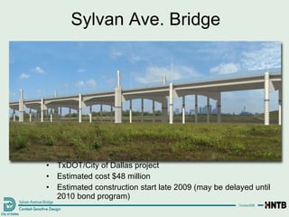
The project covers 20 miles of the Trinity River, approx. 10,000 acres
Trinity River Corridor Project Objectives This project addresses a number of regional concerns, though  flood protection  remains the  essential cornerstone  of this multi-faceted effort.  The inter-related components of the project are : Flood Protection Environmental Restoration Recreation Transportation Community/economic development
Flood Protection
Flood Protection Components Elm Fork Flood Improvements levees and wetlands for flood conveyance Dallas Floodway Extension (DFE) levees and wetlands for flood conveyance Dallas Floodway levee raise and flood conveyance (lakes)
Flood Protection - Construction Lower Chain of Wetlands Cells D, E, F & G are complete, and doing their job!
Future Work: DFE Levees & Wetlands Upper Chain of Wetlands construction starts Summer 2009 All work complete in 2014 Lamar Levee Cadillac Heights Levee Upper Chain of Wetlands
Flood Protection: Dallas Floodway Existing levees will be raised by as much as 2 ft.  Will provide 800 year flood protection from Trinity River flooding Construction can begin in 2011
Levee Section at Commerce Water Surface Elevations vs Parkway Existing Levee Elevation 429.40 Future 2-Foot Raised Levee Elevation 431.40 Ground Elevation about 400.00 Average low flow conditions that stay within the river channel of the Dallas Floodway Elevation 382.00 800-year Flood Elevation 428.97 100-year  Elevation 417.06 Same as 1908 flood of record May 1990 35-year Flood Elevation 415.24 June 2007 5-year Flood Elevation 408.38 Trinity Parkway  Flood Protected  Elevation 419.06
USACE Periodic Inspection Report #9 Periodic Inspections are done every 5 years by USACE (in addition to annual inspections) Visual inspection only; no subsurface investigation Previous inspections rated our levee system as Excellent to Very Good New rating system established by USACE in June 2007 Rating in Periodic Inspection Report #9 for our levee system was “unacceptable”
Levee Issues from Periodic Inspection #9 Encroachments Dallas County Jail Oncor Transmission Towers Penetrations Bridge Piers Pipes Dessication Cracking Erosion Vegetation Trees on/near the levees Johnson grass Levees not high enough to contain the Standard Project Flood (800 year flood event)
More frequent mowing cycles Rip rap/drainage relocation for erosion Soil borings will determine needs for diaphragm walls Work with other agencies to determine needs The Trinity River Corridor Project will provide many of the “fixes” for the unacceptable conditions of the levee system Diaphragm walls Chain of wetlands Removal of ATSF Railroad Bridge Raising/fattening the levees Resolution of Levee Issues – Next Steps
Levee will provide protection for over  $25 million in assets (near Manana and Spangler) Wetland swale will provide additional flood conveyance Final plans by March 2009 Construction Start by Fall 2009 Flood Protection: Elm Fork
Flooding in March 2006 from Interior Drainage Flood Protection: Interior Drainage Near Pavaho Sump area at Sylvan Ave. North of Bernal St. in West Dallas
Flood Protection: Interior Drainage Design contracts are underway for Baker and Pavaho Sumps and Pump Stations (can begin construction in Fall 2009) Design contracts for Able, Charlie, Delta, Trinity Portland, and Hampton pump stations were awarded on November 10, 2008 (cannot begin construction until after Corps completes Environmental Assessment in late 2010) Baker Pavaho Able Charlie Delta Hampton Trinity Portland
Environmental Restoration
Environmental Restoration 6,000 acres of bottomland hardwood forest Many bird and wildlife species Council has approved the Great Trinity Forest Management Plan  How we will operate and maintain the forest for the next 100 years Identifies wildlife and tree species Outlines annual planting, clearing, and budgetary needs Identifies a potential site for RV and tent camping in the forest
Recreation
Trinity River Corridor Project Design Concept Summary of the design concept for a 10,000-acre portion of the Trinity River Corridor from Royal Lane down to IH-635/IH-20 past the Trinity River Audubon Center.  About two-thirds of the subject area lies within the Trinity Forest. By necessity, the guidelines are mostly focused on the Trinity Lakes portion of the corridor—the  Trinity Lakes Park —about 2,200 acres in extent from the confluence to the DART Bridge.  Trinity Lakes Trinity Forest Audubon Center Confluence: Elm and West Forks Trinity Fields DART Bridge Royal Lane IH-635/  IH-20
Recreation: Trinity Fields
Recreation: Elm Fork Athletic  Complex & Trails Located east of IH-35E on Walnut Hill Lane Construction starts in September 2009; complete in April 2011
Recreation: Trinity Lakes
  Recreation: Trinity Lakes Park
Recreation: West Dallas Lake Rowing The West Dallas lake is over 129 acres and over 2000 meters long (meets Olympic standards) that will provide both recreational and competitive boating opportunities for the city and region.  Submerged wetland island to provide a rooting structure for water lilies.  Amphitheater
Recreation: West Dallas Lake Amphitheater  West Dallas Lake Amphitheater used for rowing competition viewing.
Recreation: View from West Dallas
Recreation: Urban Lake, Promenade & Arrival Plaza The promenade will accommodate 19,000 people during peak events and activities 80% of the promenade will be shaded throughout the course of the day. Downtown  Overlook Water Maze Deck Park Wetland Water Wall Arrival Plaza
Recreation: Urban Lake & Central Island Shade structures take the place of tree vegetation in this plaza preserving views of the downtown skyline and promenade, while Seating walls are integrated with the topography and provide illumination at night. Interactive fountains and dark-colored, exposed aggregate concrete paving slopes into the lake as a beach. Solar-powered Water Taxi Fountain Plaza
Located on the west levee at Beckley and Commerce Provides an observation area to watch the construction of the Trinity Project Recreation: Trinity Overlook COMMERCE STREET BRIDGE
Recreation: Natural Lake Floating Wetlands The floating wetlands are multifunctional, serving as a design aesthetic, educational demonstration, habitat and water quality improvement measure. Oak Cliff
Recreation Recreation: Corinth Wetlands The Corinth Wetlands and Oxbow Lake area is designed to be a passive observation area for understanding and appreciating wetland habitats and systems.  This environment will be a magnet for migratory birds and other aquatic and riparian wildlife and birding observation areas, boardwalks, tree groves and shaded respites are planned for this area.  Synthetic Decking
Recreation: Trinity Forest
Recreation: Trinity River Audubon Center Trinity River Audubon Center
Recreation: Trinity River Audubon Center Flood Model Children’s Area with underwater view Exhibits on the Trinity River and its ecosystem
Trinity River Audubon Center Note the many trails and wetlands surrounding the Audubon Center!
Recreation: Moore Gateway Park Located at 8 th  Street and Corinth, near the DART rail station
Recreation: Standing Wave & Santa Fe Trestle Trail Standing Wave Whitewater Course Santa Fe Trestle Trail
Recreation: Standing Wave & Santa Fe Trestle Trail DART Santa Fe Trestle Trail Corinth St. MLK, Jr. Blvd.
Recreation: Existing Trails in Rochester Park
Recreation: Future Trails Network Trinity Trails Phase I  Trinity Trails Phase II
Several gateway parks are planned and will begin design soon: Loop 12 Gateway (construction begins 5/2010) IH-20 Gateway (construction begins 6/2010) South Central/Joppa Gateway (construction begins 12/09) Improvements to Rochester Park Gateway (construction begins 12/09) Recreation: Gateway Parks
Transportation:  Trinity Parkway Toll Road
Transportation: Trinity Parkway Toll Road Trinity Parkway  complete by 2014
Transportation: Trinity Parkway Toll Road Looking South from Hampton Rd.
Transportation:  S.M. Wright Parkway
Trinity Parkway & S.M. Wright IH 45 US 175 Today’s Commuter Flow Future Commuter Flow N SM Wright Freeway Proposed Trinity Parkway Ideal  Neighborhood Rochester Park 45 Lamar
S.M. Wright Parkway Trinity Parkway connection to IH-45 eliminates need for “Dead Man’s Curve” at US 175 and S.M. Wright Provides opportunity to make S.M. Wright a low-speed road Pedestrian crossings, sidewalks, landscaping Options for split or combined meandering road
Transportation:  Sylvan Ave. Bridge
TxDOT/City of Dallas project Estimated cost $48 million Estimated construction start late 2009 (may be delayed until 2010 bond program) Sylvan Ave. Bridge
Transportation:  Signature Bridges
Transportation: Margaret Hunt Hill Bridge Visit the webcam at www.trinityrivercorridor.org   to view construction progress Margaret Hunt Hill Bridge under construction complete in 2011
Transportation: Margaret Hunt Hill Bridge Steel Fabrication in Italy Part of the center arch Central Box Girders
Continental Ave. Industrial Boulevard Spur 366 (Woodall Rodgers) IH 35E Singleton Blvd.
Transportation: Margaret McDermott Bridge Trinity Parkway  complete by 2014 Replaces IH-30 Bridge Center arch 250 ft. tall  11 main lanes, reversible HOV lane TxDOT construction to begin in late 2010
Trinity River Project Office (214) 671-9500 www.trinityrivercorridor.org ftp://ftp.dallascityhall.com

Trinity River Corridor Project

  • 1.
  • 2.
    The project covers20 miles of the Trinity River, approx. 10,000 acres
  • 3.
    Trinity River CorridorProject Objectives This project addresses a number of regional concerns, though flood protection remains the essential cornerstone of this multi-faceted effort. The inter-related components of the project are : Flood Protection Environmental Restoration Recreation Transportation Community/economic development
  • 4.
  • 5.
    Flood Protection ComponentsElm Fork Flood Improvements levees and wetlands for flood conveyance Dallas Floodway Extension (DFE) levees and wetlands for flood conveyance Dallas Floodway levee raise and flood conveyance (lakes)
  • 6.
    Flood Protection -Construction Lower Chain of Wetlands Cells D, E, F & G are complete, and doing their job!
  • 7.
    Future Work: DFELevees & Wetlands Upper Chain of Wetlands construction starts Summer 2009 All work complete in 2014 Lamar Levee Cadillac Heights Levee Upper Chain of Wetlands
  • 8.
    Flood Protection: DallasFloodway Existing levees will be raised by as much as 2 ft. Will provide 800 year flood protection from Trinity River flooding Construction can begin in 2011
  • 9.
    Levee Section atCommerce Water Surface Elevations vs Parkway Existing Levee Elevation 429.40 Future 2-Foot Raised Levee Elevation 431.40 Ground Elevation about 400.00 Average low flow conditions that stay within the river channel of the Dallas Floodway Elevation 382.00 800-year Flood Elevation 428.97 100-year Elevation 417.06 Same as 1908 flood of record May 1990 35-year Flood Elevation 415.24 June 2007 5-year Flood Elevation 408.38 Trinity Parkway Flood Protected Elevation 419.06
  • 10.
    USACE Periodic InspectionReport #9 Periodic Inspections are done every 5 years by USACE (in addition to annual inspections) Visual inspection only; no subsurface investigation Previous inspections rated our levee system as Excellent to Very Good New rating system established by USACE in June 2007 Rating in Periodic Inspection Report #9 for our levee system was “unacceptable”
  • 11.
    Levee Issues fromPeriodic Inspection #9 Encroachments Dallas County Jail Oncor Transmission Towers Penetrations Bridge Piers Pipes Dessication Cracking Erosion Vegetation Trees on/near the levees Johnson grass Levees not high enough to contain the Standard Project Flood (800 year flood event)
  • 12.
    More frequent mowingcycles Rip rap/drainage relocation for erosion Soil borings will determine needs for diaphragm walls Work with other agencies to determine needs The Trinity River Corridor Project will provide many of the “fixes” for the unacceptable conditions of the levee system Diaphragm walls Chain of wetlands Removal of ATSF Railroad Bridge Raising/fattening the levees Resolution of Levee Issues – Next Steps
  • 13.
    Levee will provideprotection for over $25 million in assets (near Manana and Spangler) Wetland swale will provide additional flood conveyance Final plans by March 2009 Construction Start by Fall 2009 Flood Protection: Elm Fork
  • 14.
    Flooding in March2006 from Interior Drainage Flood Protection: Interior Drainage Near Pavaho Sump area at Sylvan Ave. North of Bernal St. in West Dallas
  • 15.
    Flood Protection: InteriorDrainage Design contracts are underway for Baker and Pavaho Sumps and Pump Stations (can begin construction in Fall 2009) Design contracts for Able, Charlie, Delta, Trinity Portland, and Hampton pump stations were awarded on November 10, 2008 (cannot begin construction until after Corps completes Environmental Assessment in late 2010) Baker Pavaho Able Charlie Delta Hampton Trinity Portland
  • 16.
  • 17.
    Environmental Restoration 6,000acres of bottomland hardwood forest Many bird and wildlife species Council has approved the Great Trinity Forest Management Plan How we will operate and maintain the forest for the next 100 years Identifies wildlife and tree species Outlines annual planting, clearing, and budgetary needs Identifies a potential site for RV and tent camping in the forest
  • 18.
  • 19.
    Trinity River CorridorProject Design Concept Summary of the design concept for a 10,000-acre portion of the Trinity River Corridor from Royal Lane down to IH-635/IH-20 past the Trinity River Audubon Center. About two-thirds of the subject area lies within the Trinity Forest. By necessity, the guidelines are mostly focused on the Trinity Lakes portion of the corridor—the Trinity Lakes Park —about 2,200 acres in extent from the confluence to the DART Bridge. Trinity Lakes Trinity Forest Audubon Center Confluence: Elm and West Forks Trinity Fields DART Bridge Royal Lane IH-635/ IH-20
  • 20.
  • 21.
    Recreation: Elm ForkAthletic Complex & Trails Located east of IH-35E on Walnut Hill Lane Construction starts in September 2009; complete in April 2011
  • 22.
  • 23.
    Recreation:Trinity Lakes Park
  • 24.
    Recreation: West DallasLake Rowing The West Dallas lake is over 129 acres and over 2000 meters long (meets Olympic standards) that will provide both recreational and competitive boating opportunities for the city and region. Submerged wetland island to provide a rooting structure for water lilies. Amphitheater
  • 25.
    Recreation: West DallasLake Amphitheater West Dallas Lake Amphitheater used for rowing competition viewing.
  • 26.
  • 27.
    Recreation: Urban Lake,Promenade & Arrival Plaza The promenade will accommodate 19,000 people during peak events and activities 80% of the promenade will be shaded throughout the course of the day. Downtown Overlook Water Maze Deck Park Wetland Water Wall Arrival Plaza
  • 28.
    Recreation: Urban Lake& Central Island Shade structures take the place of tree vegetation in this plaza preserving views of the downtown skyline and promenade, while Seating walls are integrated with the topography and provide illumination at night. Interactive fountains and dark-colored, exposed aggregate concrete paving slopes into the lake as a beach. Solar-powered Water Taxi Fountain Plaza
  • 29.
    Located on thewest levee at Beckley and Commerce Provides an observation area to watch the construction of the Trinity Project Recreation: Trinity Overlook COMMERCE STREET BRIDGE
  • 30.
    Recreation: Natural LakeFloating Wetlands The floating wetlands are multifunctional, serving as a design aesthetic, educational demonstration, habitat and water quality improvement measure. Oak Cliff
  • 31.
    Recreation Recreation: CorinthWetlands The Corinth Wetlands and Oxbow Lake area is designed to be a passive observation area for understanding and appreciating wetland habitats and systems. This environment will be a magnet for migratory birds and other aquatic and riparian wildlife and birding observation areas, boardwalks, tree groves and shaded respites are planned for this area. Synthetic Decking
  • 32.
  • 33.
    Recreation: Trinity RiverAudubon Center Trinity River Audubon Center
  • 34.
    Recreation: Trinity RiverAudubon Center Flood Model Children’s Area with underwater view Exhibits on the Trinity River and its ecosystem
  • 35.
    Trinity River AudubonCenter Note the many trails and wetlands surrounding the Audubon Center!
  • 36.
    Recreation: Moore GatewayPark Located at 8 th Street and Corinth, near the DART rail station
  • 37.
    Recreation: Standing Wave& Santa Fe Trestle Trail Standing Wave Whitewater Course Santa Fe Trestle Trail
  • 38.
    Recreation: Standing Wave& Santa Fe Trestle Trail DART Santa Fe Trestle Trail Corinth St. MLK, Jr. Blvd.
  • 39.
    Recreation: Existing Trailsin Rochester Park
  • 40.
    Recreation: Future TrailsNetwork Trinity Trails Phase I Trinity Trails Phase II
  • 41.
    Several gateway parksare planned and will begin design soon: Loop 12 Gateway (construction begins 5/2010) IH-20 Gateway (construction begins 6/2010) South Central/Joppa Gateway (construction begins 12/09) Improvements to Rochester Park Gateway (construction begins 12/09) Recreation: Gateway Parks
  • 42.
    Transportation: TrinityParkway Toll Road
  • 43.
    Transportation: Trinity ParkwayToll Road Trinity Parkway complete by 2014
  • 44.
    Transportation: Trinity ParkwayToll Road Looking South from Hampton Rd.
  • 45.
    Transportation: S.M.Wright Parkway
  • 46.
    Trinity Parkway &S.M. Wright IH 45 US 175 Today’s Commuter Flow Future Commuter Flow N SM Wright Freeway Proposed Trinity Parkway Ideal Neighborhood Rochester Park 45 Lamar
  • 47.
    S.M. Wright ParkwayTrinity Parkway connection to IH-45 eliminates need for “Dead Man’s Curve” at US 175 and S.M. Wright Provides opportunity to make S.M. Wright a low-speed road Pedestrian crossings, sidewalks, landscaping Options for split or combined meandering road
  • 48.
  • 49.
    TxDOT/City of Dallasproject Estimated cost $48 million Estimated construction start late 2009 (may be delayed until 2010 bond program) Sylvan Ave. Bridge
  • 50.
  • 51.
    Transportation: Margaret HuntHill Bridge Visit the webcam at www.trinityrivercorridor.org to view construction progress Margaret Hunt Hill Bridge under construction complete in 2011
  • 52.
    Transportation: Margaret HuntHill Bridge Steel Fabrication in Italy Part of the center arch Central Box Girders
  • 53.
    Continental Ave. IndustrialBoulevard Spur 366 (Woodall Rodgers) IH 35E Singleton Blvd.
  • 54.
    Transportation: Margaret McDermottBridge Trinity Parkway complete by 2014 Replaces IH-30 Bridge Center arch 250 ft. tall 11 main lanes, reversible HOV lane TxDOT construction to begin in late 2010
  • 55.
    Trinity River ProjectOffice (214) 671-9500 www.trinityrivercorridor.org ftp://ftp.dallascityhall.com