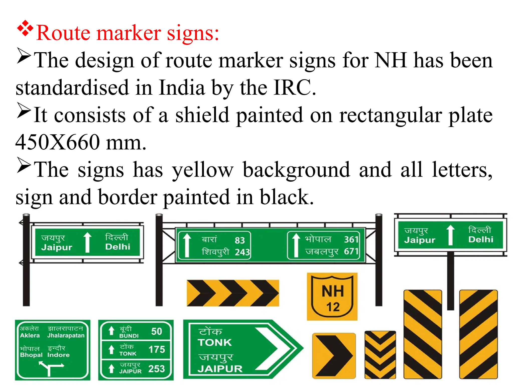
TRAFFIC ENGINEERING
HIGHWAY ENGINEERING
(2150601)
Prepared By:
Prof. Sadanand Sahu
DEPARTMENT OF CIVIL ENGINEERING
GUJARAT POWER ENGINEERING & RESEARCH INSTITUTE, MEHSANA
TRAFFIC CONTROL
DEVICES
1. Signs
2. Signals
3. Marking
4. Traffic Islands
1. Signs
The government of Gujarat has adopted
various traffic signs prepared by IRC.
As per IRC, there are three types of traffic
signs.
A. Regularity or Mandatory signs.
B. Warning Signs.
C. Informatory signs.
A. Regularity or Mandatory
signs
Regularity or Mandatory signs are meant to
inform road users of certain laws, regulation
and prohibition; the violation of this signs is a
legal offence.
B. Warning Signs
Warning signs are used to warn the road users
of certain hazardous conditions that exist on
the roadway.
C. Informatory Signs
These signs are used to guide road users along
routes, inform them of destination and distance
and provide with information to make travel
easier, safe and pleasant.
These signs are placed at distance 0.6 m from
the kerb and at 2.0 to 3.0 m from the edge of
carriage way in case of roads without kerb.
Route marker signs:
The design of route marker signs for NH has been
standardised in India by the IRC.
It consists of a shield painted on rectangular plate
450X660 mm.
The signs has yellow background and all letters,
sign and border painted in black.
2. Signals
Traffic signals are provided at road intersection.
The main requirements of traffic signals are to
draw attention, provide meaning and time to
respond and to have a minimum waste of time.
Red : Vehicles must stop.
Yellow : Lights about to change.
Green :Vehicles can proceed.
Advantages:
1. Reduce certain types of accidents.
2. Improve safety and efficiency of movement of vehicles.
3. More economical than manual control.
Disadvantages:
1. The rear end collision may increase.
2. Improper design and location of signals may lead to
violations of control system.
3. Failure of the signal due to electric power failure or any
other defect may cause confusion to the road users.
Types of Traffic Signals
1. Traffic control signals.
a) Fixed time signals.
b) Manually operated signals.
c) Automatic signals.
2. Pedestrian signals.
3. Special traffic signals.
3. Marking
Road marking are the lines, patterns, words, symbols
or reflectors on the pavement, kerb, sides of islands or
on the fixed objects within or near the roadway.
Markings are for control, warning and guidance of
road users.
IRC standardized these marking (IRC:35-1970).
Various types of marking are,
1) Pavement marking.
2) Kerb marking.
3) Object marking.
4) Reflector unit marking.
1) Pavement Marking
Pavement or carriage way markings may
generally be of white paint.
Yellow colour marking are used to indicate
parking restriction and for continuous centre line
marking.
Various pavement marking are:
a) Centre line.
b) Lane line.
c) Stop line.
d) Cross walk lines.
e) Parking space limits.
a) Centre line:
• These are meant to separate the opposing
streams of traffic on undivided tow-way roads
on NH and SH, with two or three lanes.
• single broken line of width 0.1 m and 3.0 m
segments and 4.5 m gaps may be painted on
straight stretches.
b) Lane lines:
• These marking divide the carriage way into
separate lanes on either side of the centre line.
• These help to guide the traffic and regulate it.
c) Stop lines:
• These are meant for vehicles to stop near the
pedestrian crossing, signalized intersection etc.
where vehicles have to stop and proceed.
d) Cross walk lines:
• These marking are provided at important
intersection to facilitate pedestrians to cross a
road.
• The Width of the crossing may be between 2.0
and 4.0 m.
2) Kerb marking
Marking on the kerb indicate certain
regulations.
Marking on the kerb and edges of islands with
alternate black and white line increase the
visibility from a long distance.
3) Object marking
Physical obstruction on or near the roadway
are hazardous and hence should be properly
marked.
Typical obstructions are supports for bridge,
level crossing gates, signs and signals, traffic
island, narrow bridges etc.
4) Reflector unit marking
These are used as hazard markers and guide
markers for safe driving during night.
Traffic Island
4. Traffic Islands
Traffic island are raised areas constructed within
the roadway to establish physical channels
through which the vehicular traffic may be
guided.
Function of traffic island:
i. To segregate the pedestrians and vehicles.
ii. To separate traffic into specified path.
iii. To increase safety.
iv. To diverts traffic from obstacles and expedite
the traffic flow.
Advantages:
i. It provides smooth and controlled traffic flow.
ii. It reduces the accident and increases safety.
iii. It gives uniform speed of traffic.
iv. No need of police control.
Disadvantages:
i. It consumes useful traffic area.
ii. It increase travel distance.
iii. Width of traffic lane decreases.
Types of Traffic Island:
1. Divisional Island.
2. Channelizing Island.
3. Pedestrian Loading Island.
4. Rotary Island.
1. Divisional Island
These are intended to separate opposing traffic
flow on a highway with four or more lanes.
Dividing the highway into two one-way roadway,
the head on collisions are eliminated.
The kerb should be high enough to prevent
vehicles from entering into the island.
2.Channelizing Island
These are used to guide the traffic into proper
channel through the intersection area.
Various uses of channelizing island are:
• The area of possible conflicts between traffic
stream is reduced.
• They are useful when direction of flow is to be
changed.
• They serve as convenient location for other
traffic control devices.
• They serve as refuge islands for pedestrians.
3. Pedestrian Loading Island
They are provided at regular bus stops and
similar places for the protection of passengers.
A pedestrian island at or near a cross walk to aid
and protect pedestrian crossing the carriage way
may be termed as pedestrian refuse island.
4.Rotatary Island.
It is a large central island of a rotary intersection.
Various shapes of rotary islands are shown in fig:
Various shapes Rotary Island
Intersection
• Intersection is also commonly known
as crossroad is any place where two or more
than two roads intersect or meet each other.
• Highway Intersection has a considerable
influence on safety and efficiency of traffic
movement.
• Classification of Intersection
a) At grade Intersection
b) Grade separated Intersection (Interchange)
Types of Manoeuvres
Forms of Intersection at Grade
Intersection at Grade
Unchannelized
intersection
Channelized
intersection
Rotary
Intersection
Unchannelized Intersection
Channelized Intersections
Rotary Intersection
Interchange
• In a grade separated intersection (interchange)
the intersecting roadways are placed at different
elevations to allow uninterrupted traffic flow.
• It may be underpass or over crossing.
• Various types of Interchanges are:
I. Cloverleaf Interchange
II. Diamond Interchange
III. Rotary Interchange
Full- Cloverleaf Interchange
Rotary Interchange
Traffic Engg(Traffic Sign & Intersection).pptx

Traffic Engg(Traffic Sign & Intersection).pptx

  • 1.
    TRAFFIC ENGINEERING HIGHWAY ENGINEERING (2150601) PreparedBy: Prof. Sadanand Sahu DEPARTMENT OF CIVIL ENGINEERING GUJARAT POWER ENGINEERING & RESEARCH INSTITUTE, MEHSANA
  • 2.
    TRAFFIC CONTROL DEVICES 1. Signs 2.Signals 3. Marking 4. Traffic Islands
  • 3.
    1. Signs The governmentof Gujarat has adopted various traffic signs prepared by IRC. As per IRC, there are three types of traffic signs. A. Regularity or Mandatory signs. B. Warning Signs. C. Informatory signs.
  • 4.
    A. Regularity orMandatory signs Regularity or Mandatory signs are meant to inform road users of certain laws, regulation and prohibition; the violation of this signs is a legal offence.
  • 5.
    B. Warning Signs Warningsigns are used to warn the road users of certain hazardous conditions that exist on the roadway.
  • 6.
    C. Informatory Signs Thesesigns are used to guide road users along routes, inform them of destination and distance and provide with information to make travel easier, safe and pleasant. These signs are placed at distance 0.6 m from the kerb and at 2.0 to 3.0 m from the edge of carriage way in case of roads without kerb.
  • 7.
    Route marker signs: Thedesign of route marker signs for NH has been standardised in India by the IRC. It consists of a shield painted on rectangular plate 450X660 mm. The signs has yellow background and all letters, sign and border painted in black.
  • 8.
    2. Signals Traffic signalsare provided at road intersection. The main requirements of traffic signals are to draw attention, provide meaning and time to respond and to have a minimum waste of time. Red : Vehicles must stop. Yellow : Lights about to change. Green :Vehicles can proceed.
  • 9.
    Advantages: 1. Reduce certaintypes of accidents. 2. Improve safety and efficiency of movement of vehicles. 3. More economical than manual control. Disadvantages: 1. The rear end collision may increase. 2. Improper design and location of signals may lead to violations of control system. 3. Failure of the signal due to electric power failure or any other defect may cause confusion to the road users.
  • 10.
    Types of TrafficSignals 1. Traffic control signals. a) Fixed time signals. b) Manually operated signals. c) Automatic signals. 2. Pedestrian signals. 3. Special traffic signals.
  • 11.
    3. Marking Road markingare the lines, patterns, words, symbols or reflectors on the pavement, kerb, sides of islands or on the fixed objects within or near the roadway. Markings are for control, warning and guidance of road users. IRC standardized these marking (IRC:35-1970). Various types of marking are, 1) Pavement marking. 2) Kerb marking. 3) Object marking. 4) Reflector unit marking.
  • 12.
    1) Pavement Marking Pavementor carriage way markings may generally be of white paint. Yellow colour marking are used to indicate parking restriction and for continuous centre line marking. Various pavement marking are: a) Centre line. b) Lane line. c) Stop line. d) Cross walk lines. e) Parking space limits.
  • 13.
    a) Centre line: •These are meant to separate the opposing streams of traffic on undivided tow-way roads on NH and SH, with two or three lanes. • single broken line of width 0.1 m and 3.0 m segments and 4.5 m gaps may be painted on straight stretches. b) Lane lines: • These marking divide the carriage way into separate lanes on either side of the centre line. • These help to guide the traffic and regulate it.
  • 14.
    c) Stop lines: •These are meant for vehicles to stop near the pedestrian crossing, signalized intersection etc. where vehicles have to stop and proceed. d) Cross walk lines: • These marking are provided at important intersection to facilitate pedestrians to cross a road. • The Width of the crossing may be between 2.0 and 4.0 m.
  • 16.
    2) Kerb marking Markingon the kerb indicate certain regulations. Marking on the kerb and edges of islands with alternate black and white line increase the visibility from a long distance.
  • 17.
    3) Object marking Physicalobstruction on or near the roadway are hazardous and hence should be properly marked. Typical obstructions are supports for bridge, level crossing gates, signs and signals, traffic island, narrow bridges etc. 4) Reflector unit marking These are used as hazard markers and guide markers for safe driving during night.
  • 18.
  • 20.
    4. Traffic Islands Trafficisland are raised areas constructed within the roadway to establish physical channels through which the vehicular traffic may be guided. Function of traffic island: i. To segregate the pedestrians and vehicles. ii. To separate traffic into specified path. iii. To increase safety. iv. To diverts traffic from obstacles and expedite the traffic flow.
  • 21.
    Advantages: i. It providessmooth and controlled traffic flow. ii. It reduces the accident and increases safety. iii. It gives uniform speed of traffic. iv. No need of police control. Disadvantages: i. It consumes useful traffic area. ii. It increase travel distance. iii. Width of traffic lane decreases.
  • 22.
    Types of TrafficIsland: 1. Divisional Island. 2. Channelizing Island. 3. Pedestrian Loading Island. 4. Rotary Island.
  • 23.
    1. Divisional Island Theseare intended to separate opposing traffic flow on a highway with four or more lanes. Dividing the highway into two one-way roadway, the head on collisions are eliminated. The kerb should be high enough to prevent vehicles from entering into the island.
  • 24.
    2.Channelizing Island These areused to guide the traffic into proper channel through the intersection area.
  • 26.
    Various uses ofchannelizing island are: • The area of possible conflicts between traffic stream is reduced. • They are useful when direction of flow is to be changed. • They serve as convenient location for other traffic control devices. • They serve as refuge islands for pedestrians.
  • 27.
    3. Pedestrian LoadingIsland They are provided at regular bus stops and similar places for the protection of passengers. A pedestrian island at or near a cross walk to aid and protect pedestrian crossing the carriage way may be termed as pedestrian refuse island.
  • 28.
    4.Rotatary Island. It isa large central island of a rotary intersection. Various shapes of rotary islands are shown in fig:
  • 29.
  • 30.
    Intersection • Intersection isalso commonly known as crossroad is any place where two or more than two roads intersect or meet each other. • Highway Intersection has a considerable influence on safety and efficiency of traffic movement. • Classification of Intersection a) At grade Intersection b) Grade separated Intersection (Interchange)
  • 31.
  • 32.
  • 33.
  • 34.
  • 35.
  • 36.
  • 37.
    Interchange • In agrade separated intersection (interchange) the intersecting roadways are placed at different elevations to allow uninterrupted traffic flow. • It may be underpass or over crossing. • Various types of Interchanges are: I. Cloverleaf Interchange II. Diamond Interchange III. Rotary Interchange
  • 38.
  • 40.