1) The document describes a study applying poststack acoustic impedance inversion to characterize subsalt reservoirs using 3D seismic data from the Walker Ridge protraction area in the Gulf of Mexico.
2) Inversion of a depth-migrated seismic volume was able to derive relative acoustic impedance, which was then used with a background model to estimate absolute acoustic impedance.
3) Comparison of inverted acoustic impedance to well logs showed good agreement, indicating the potential for quantitative seismic analysis of subsalt reservoirs despite challenges of low frequencies and complex salt geometry.
Anisotropic Avo Analysis for Reservoir Characterization in Derby Field Southe...IOSRJAP
Anisotropic AVO analysis for reservoir characterization in Derby field southeastern Niger delta has been investigated. The objective of this study was to investigate the AVO response of shale over gas sandsonisotropic and anisotropic synthetic models and the real CDP gathers. This was done by plotting amplitude of reflections versus offsets and carrying out AVO intercept-gradient analysison HD1horizon. The results of the models were compared with the real CDP gather to deduce the robust synthetic model for efficient AVO analysis in the field. Well, CDP processed gathers and Hampson-Russell GEOVIEW and AVO module were used for the analysis. Results revealed that the plots of amplitude versus offset of the isotropic and anisotropic synthetic models agree at near offset but show opposite AVO response due to increasing contributions of seismic anisotropy at far offsets. The results of the anisotropic synthetic model correlates well with the CDP gathers indicating that seismic anisotropy is an important factor in AVO analysis. Results also show that a bright spot indicative of gas charged sands was delineated for the isotropic and anisotropic models but with different classes of AVO anomalies andproducts. The isotropic synthetic model show a class II AVO anomaly with a positive AVO product, while the anisotropic model show a class IV AVO anomaly with a negative AVO product comparable to the real CDP gather.These analysesclearly show that description of rock without anisotropy especially, seismic anisotropy is incomplete since most rocks are not completely isotropic. Therefore, accounting for seismic anisotropy in AVO synthetic modelling will ensure that the correct earth model is predicted and the reservoir is adequately characterized.
Hydrocarbon potential of the Borno Basin through Electrofacies and depositional environment analysis was carried out from well log and seismic reflection data to reassess the potential of the Basin thereby justifying the huge financial commitment of the Government. The reflection configuration pattern from the seismic reflection lines is characterized by variation from parallel, continuous and strong amplitude to sub parallel, chaotic discontinuous and low amplitude which indicate a variation from a low energy basinal setting of uniform rate of continental deposition to high energy environment of monolithologic deposits. Furthermore, the derivable log signatures shows a variation from serrated mud/sand to serrated blocky to serrated funnel and bell shapes with depth. This imply a stable massive mud/sand rich basinwide environment to an upward regressive sequence of bar deposit followed by a deltaic estuarine clastic sediment to gradual upward transgressive decrease in grain size to a fluvial point bar deposit. These environments identified from the research are known to be hydrocarbon province.
Brief review on Direct hydrocarbon indicators (DHI).
The presentation is a part from Seismic data interpretation course that i teach for undergraduates.
The sources are indicated in the references list.
Contact me via: hatem_refaat95@hotmail.com
Velocity analysis and depth conversion in the offshre kaboudia permitGuizani Aymen
Accurate depth conversion is vital to map depth and thickness of subsurface layers interpreted from seismic reflection images and for structural model building, but depth conversion requires good quality seismic velocity information. The number and distribution of wells with velocity information in the Kaboudia permit is poor, in contrast, a 3D post-stack seismic reflection data covers the area of interest and providing a good distribution of stacking velocities.
Seismic stacking velocities are an outcome of seismic processing and are thus not a direct measurement of the speed of sound in rocks. To improve the quality of the depth conversion workflow in this area characterized by a complex geological environment a methodology is suggested to calibrate stacking velocities against borehole velocity measurements. This would allow the widespread stacking velocities to be used to create a more constrained velocity model of the interpreted layers in the Kaboudia permit.
The methodology consist of computing calibration coefficient resulting from comparing seismic velocities and wells data then Multiply depths derived from stacking velocities by calibration coefficient mapped with different options of gridding. the robustness of this process is assessed by putting the resulting converted surfaces in contrast with other simple depth conversion workflows and by relative errors to wells and uncertainty analysis.
Statistical Tuning Chart for Mapping Porosity Thickness: a Case Study of Chan...TELKOMNIKA JOURNAL
Reservoir assessment is not only controlled by the structural framework but also stratigraphical
features. Stratigraphical interpretation, which is related to seismic amplitude interpretation, is used to
describe petrophysical aspects of channel sand reservoirs such as net porosity and thickness. This paper
aims to map the porosity thickness for a case study of channel sand bodies reservoir in the Kutei basin.
The study area is complex channel reservoir system that appears to occupy specific area within the
depositional system. The geometry of the sediment channel, which thins toward the channel margins,
makes this feature similar to be wedge model that could possibly be influenced by tuning effects. The
tuning effects introduce pitfall in interpreting high-quality reservoir that is affected by contrasts in acoustic
impedance. In order to distinguish high amplitude responses caused by tuning effects and acoustic
properties, the analysis of amplitude responses needs to be correlated to the reservoir thickness. The
statistical tuning chart is one of the techniques used to correlate amplitude responses and the reservoir
thickness. The application of this technique to real data sets shows net porosity thickness map over the
targeted reservoir. Thus, high-quality reservoir characterization can be performed to delineate geometric
framework of the reservoir.
Reservoir characterization technique based on geostatistical inversion methodiosrjce
IOSR Journal of Applied Geology and Geophysics (IOSR-JAGG) is a double blind peer reviewed International Journal that provides rapid publication (within a month) of articles in all areas of Applied Geology and Geophysics. The journal welcomes publications of high quality papers on theoretical developments and practical applications in Applied Geology and Geophysics. Original research papers, state-of-the-art reviews, and high quality technical notes are invited for publications.
Avo ppt (Amplitude Variation with Offset)Haseeb Ahmed
AVO/AVA can physically explain presence of hydrocarbon in the reservoirs and the thickness, porosity, density, velocity, lithology and fluid content of the reservoir of the rock can be estimated.
Effects of shale volume distribution on the elastic properties of reserviors ...DR. RICHMOND IDEOZU
Shale volume (Vsh) estimation has been carried out on three selected reservoirs (Nan.1, Nan.2, and Nan.4) distributed across four wells (01, 03, 06, and 12) in Nantin Field, using petrophysical analysis and reservoir modeling techniques with a view to understanding the reservoir elastic properties. Materials utilized for this research work include: Well Log data (Gamma Ray Log, Resistivity Log, Sonic Log, Density Log, Neutron porosity log), and a 3-D Seismic volume were used for the study. Sand and shale were the prevalent lithologies in Nantin Field. Nan. 1 reservoir was thickest in Nantin well 12 (29.7ft), Nantin 2 reservoir was thickest in Nantin Well 12 (30.9ft) while Nantin 4 reservoir was thickest in Well 3 (72ft). Correlation well panel across the Field showed that Nantin 4 reservoir, was thicker than Nan 1 and Nan 2 Reservoir respectively. Normal and synthetic Faults were also mapped, the trapping system in the field includes anticlines in association with fault closures. The thicknesses and lateral extents of these reservoirs were delineated into three zones (1, 2, and 3) which were modeled appropriately. Petrophysical and some elasticity parameters such as Poisson ratio (PR), Acoustic Impedance (AI), and Reflectivity Coefficient (RC) were evaluated for the wells. The results from elasticity evaluation showed a high Poisson Ratio of 0.40 in Nantin 2 reservoir of Well 12 based on high shale volume distribution of 0.70 indicating high stress level and possible boundary to hydraulic fracture. The lowest Poisson Ratio was evaluated in Nantin reservoir of Well 1 with lowest shale volume of 0.18 which indicates weak zones and may not constrain a fracturing job. Results from Acoustic impedance showed a high AI value of 7994.3 in Nan 2 Reservoir compared to Nan.1 which has the least AI value of 7447.3 because of low shale volume. A higher Reflectivity Coefficient of 0.01 was recorded in Nan.2 reservoir indicating bright spot while a lower RC of -0.00023 was recorded in Nan.4 Reservoir indicating dim spot. Hydrocarbon volume estimate of the three reservoirs showed 163mmstb in Nan.1 reservoir, 169mmstb, in Nantin 2 reservoir and 115mmstb in Nan. 4 Reservoir. The reservoirs encountered were faulted and laterally extensive. Nantin 2 reservoir was more prolific with a STOIIP of 169 mmstb compared to Nan. 1 with a STOIP of 163 mmstb and Nantin.4 with a STOIP of 115 mmstb, because of its good petrophysical values, facies quality and low shale volume distributions.
PetroTeach Free Webinar by Dr. Andrew Ross on Seismic Reservoir CharacterizationPetro Teach
A reliable reservoir model is an invaluable tool for risk reduction. I will give an overview of seismic reservoir characterization and the quantitative interpretation workflow including the use of pre and post stack seismic attributes and inversion outputs for mapping reservoir properties and integration of the attribute output with petrophysical data to create quantitative reservoir models.
PetroTeach Free Webinar on Seismic Reservoir CharacterizationPetroTeach1
A reliable reservoir model is an invaluable tool for risk reduction. Dr. Andrew Ross gave an overview of seismic reservoir characterization and the quantitative interpretation workflow including the use of pre and post-stack seismic attributes and inversion outputs for mapping reservoir properties and integration of the attribute output with petrophysical data to create quantitative reservoir models.
Delineation of Hydrocarbon Bearing Reservoirs from Surface Seismic and Well L...IOSR Journals
Hydrocarbon reservoir has been delineated and their boundaries mapped using direct indicators from 3-D seismic and well log data from an oil field in Nembe creek, Niger Delta region. Well log signatures were employed to identify hydrocarbon bearing sands. Well to seismic correlation revealed that these reservoirs tied with direct hydrocarbon indicators on the seismic section. The results of the interpreted well logs revealed that the hydrocarbon interval in the area occurs between 6450ft to 6533ft for well A, 6449ft to 6537ft for well B and 6629ft to 6704ft for well C; which were delineated using the resistivity, water saturation and gamma ray logs. Cross plot analysis was carried out to validate the sensitivity of the rock attributes to reservoir saturation condition. Analysis of the extracted seismic attribute slices revealed HD5000 as hydrocarbon bearing reservoir.
18494_Guided Facies Modeling using 3D Seismic and Well
tle31050528.1
1. S e i s m i c i n v e r s i o n f o r r e s e r v o i r p r o p e r t i e s
528 The Leading Edge May 2012
SPECIAL SECTION: Seismic inversion for reservoir properties
Quantitative application of poststack acoustic impedance
inversion to subsalt reservoir development
The cost and complexity of deep-water subsalt development
wells is so great that a very limited spatial sampling of the
targetreservoirisachievablewithwelldata.Thus,thequantitative
use of seismic data becomes of paramount importance.
Poststack seismic amplitude inversion, and poststack seismic
attribute analysis and modeling, are frequently employed to per-
form quantitative prediction of reservoir properties from surface
seismic data.
Several authors have shown that both absolute and relative
acoustic impedance (AAI and RAI, respectively) derived from
poststack seismic amplitude inversion can be useful for quantita-
tive estimates of summary reservoir properties such as average
porosity, net-to-gross, and others. This includes suprasalt and
minibasin clastic reservoirs typically encountered in the Middle
and Lower Tertiary plays in the deep-water Gulf of Mexico (sev-
eral of which are also encountered subsalt), where depth to target
can exceed 9000 m and highest frequencies at target are often
rather low (20–25 Hz) (Bogan et al., 2003, Vernik et al., 2002).
With sufficient supporting data and appropriate angle of in-
cidence coverage available, prestack inversion for elastic proper-
ties is a preferred method for quantitative clastic seismic reservoir
characterization. Calibration with mechanical rock properties,
and application of sophisticated rock physics models, are both
possible with such data. However, this is rarely the case with sub-
salt plays, partly due to illumination and amplitude normaliza-
tion uncertainties, and partly due to skepticism regarding the vi-
ability of elastic modeling in the subsalt case (Vigh et al., 2011).
Clearly, subsalt amplitude fidelity is of primary concern
to quantitative practitioners, whether working with post- or
prestack data. Subsalt amplitude data processing is typically di-
rected at a good image for horizon interpretation, and quantita-
tive methods are rarely discussed in literature (see Bui et al., 2011
for an exception).
Published quantitative work in the subsalt regime is largely
restricted to low-resolution activities such as pore-pressure pre-
diction. This article describes a study that shows there is reason
for optimism regarding the use of quantitative subsalt seismic
analysis for reservoir description, and for derisking deep target
drilling locations. For deeper targets, limited bandwidth and ver-
tical resolution restricts us to the development of gross seismi-
cally derived reservoir statistics.
This study builds on initial, promising, work undertaken in
the Green Canyon protraction area in the Gulf of Mexico (Bui
et al., 2011), which covered an area of complex salt and mini-
basin geometry. The intent is to investigate whether the favor-
able Green Canyon impedance inversion results are achievable
elsewhere. Additional inversion work, and a review of processing
methodologies, was undertaken to evaluate amplitude fidelity
and develop additional results.
For simplicity, we refer to the lower Tertiary Wilcox equiva-
CHARLES WAGNER, ALFONSO GONZALEZ, VINOD AGARWAL, ADAM KOESOEMADINATA, DAVID NG, STEVENTRARES, and NORMAN BILES, WesternGeco
KEVIN FISHER, Schlumberger Data & Consulting Services
lent rocks in the study area as “Wilcox.” Also, the St. Malo pros-
pect was originally called Dana Point but was renamed after the
well was deepened. Some well-log files (and thus, some plots be-
low) retained the Dana Point designation.
Background
A small area—equivalent to about nine blocks (9 × 23 km2
)
was selected from a much larger spec data volume (~180 blocks)
around the Das Bump and St. Malo prospects in the Walker
Ridge protraction area—deeper water than Green Canyon, and
closer to the outward limits of the salt canopy (Figure 1). Re-
cent operator activity in this area has been focused on the deep
(8000 -10,000 m) lower Tertiary Wilcox equivalent play, wide-
spread thick sands with reservoirs characterized by hydrocarbon
accumulations over large salt-cored structures. The sands have
complex mineralogy, moderate porosity, low permeability, and
the reservoirs are often compartmentalized.
A wide-azimuth multiclient seismic survey was acquired
over the study area in 2009, processed with 3D generalized sur-
face multiple prediction (GSMP), multiple suppression and an
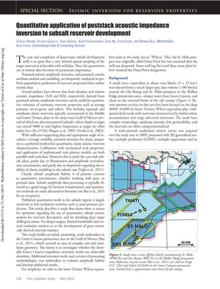
Figure 1. Study area is nine offshore blocks encompassing St. Malo
(WR678) and Das Bump (WR724) in the Walker Ridge protaction
area. References to prior work (Bui et al., 2011) are sited at Tonga
(GC 726) and Tahiti (GC640) in the Green Canyon protraction
area. Dashed line is approximate outer limit of salt canopy.
Downloaded06/15/15to73.166.180.91.RedistributionsubjecttoSEGlicenseorcopyright;seeTermsofUseathttp://library.seg.org/
2. May 2012 The Leading Edge 529
S e i s m i c i n v e r s i o n f o r r e s e r v o i r p r o p e r t i e s
cally reject plans that call for a full suite of logs from surface to
total depth (TD). In these cases, we are constrained to compar-
ing measured seismic data with a mix of measured, modeled, and
often derived data from well logs, core, pressure measurements,
and measured data from hybrid acquisition methods such as a
vertical seismic profile (VSP). For this study, publically available
well logs were edited and petrophysical analyses were prepared.
In addition to direct comparisons, we can also test the re-
inverse-Q function, and depth-mi-
grated (up to 25 Hz) using a pro-
prietary anisotropic (VTI) prestack
reverse time migration (RTM)
algorithm. Three iterations of salt
interpretation and multiazimuth
anisotropic tomography were uti-
lized for salt body and final migra-
tion velocity model development
(Vigh et al., 2011).
Amplitude fidelity
Amplitude preservation during
RTM requires proper boundary
conditions and a properly normal-
ized imaging condition (Zhang
and Sun, 2009). In RTM, the
image is constructed using Claer-
bout’s imaging principle by tak-
ing the zero-lag crosscorrelation
of extrapolated source and receiver
wavefields.
For amplitude preservation,
the cross-correlation is normalized
by the shot-by-shot illumination.
In practice, the shot-by-shot nor-
malization is unstable in regions
of low or no illumination, and
modifications have been proposed
to stabilize the image (Cogan et al.,
2011). The modified normaliza-
tion scheme was used to process the
data set used for this study.
Illumination compensation be-
low salt is challenging, in particular
because of the strong influence salt
geometry has on wave propagation.
This is demonstrated in Figure 2,
showing the illumination pattern
from five surface shots in a wide-
azimuth (WAZ) data set with a salt
body with complex geometry.
Notice the focusing and defo-
cusing effect that salt has on subsalt
illumination. This example demon-
strates that small variations in the
salt geometry have strong effects on
subsalt illumination.
Illumination studies are an
important part of any quantitative
work that depends on imaging amplitudes; these studies identify
those regions where illumination is good and stable, and those
regions where illumination compensation has high uncertainty,
so proper preconditioning of amplitude is done before inversion
or attribute analysis.
Validation of seismic amplitude data has always been prob-
lematic. Our frugal colleagues in the engineering discipline typi-
Figure 2. (top) Seismic section from a WAZ data set; the arrows show the locations of five shots to
illustrate their contribution to the illumination; top salt (orange), base salt (yellow). (middle) Sum of
illumination weights for the five selected shots. Note, in particular, the complex illumination patterns
below salt, created by focusing and defocusing of energy as it propagates in and out of the salt body.
White indicates no illumination. (bottom) Stack volume formed from APSDM RTM-migrated full-
waveform well synthetic gather. (left) Inverted acoustic impedance from synthetic APSDM RTM stack
with well-log impedance. (center) Log overlay. (right) Red = measured logs, blue = inversion result,
and green = background model.
Downloaded06/15/15to73.166.180.91.RedistributionsubjecttoSEGlicenseorcopyright;seeTermsofUseathttp://library.seg.org/
3. 530 The Leading Edge May 2012
S e i s m i c i n v e r s i o n f o r r e s e r v o i r p r o p e r t i e s
sponse of our data processing methods against models—ensur-
ing that the introduction of processing artifacts is kept to a mini-
mum and understood reasonably well.
As part of this study, activities were undertaken to develop
synthetic prestack data from logs, to evaluate the preservation of
synthetic data through processing and migration, and
to evaluate the recovery of acoustic impedance from
the migrated synthetic data via poststack inversion.
A forward-modeled elastic full-waveform gather
was constructed and run through a production VTI
anisotropic prestack depth migration (APSDM)
processing flow to produce an angle gather, which
was subsequently stacked using near angles (to ap-
proximate vertical incidence) and replicated to form
a small 3D data set. A wavelet was extracted from that
data set using the logs from the model construction
process, and a poststack absolute acoustic impedance
inversion was performed. The stack data set and in-
version results (shown at the bottom of Figure 2) in-
dicate that the workflow recovers acoustic impedance
rather well.
Forward models derived from well logs need to
be constructed thoughtfully, as they are not without
problems, particularly with respect to the effects of
velocity anisotropy on well logs. Notably, establish-
ing a depth/time relationship using check shots or
VSP data in a deviated well can have high uncertainty. Without
a walkaway (or walkabove) source that keeps as close to vertical
incidence as possible, such measurements suffer from the same
anisotropy effects as surface seismic acquisition. Only vertical, or
near-vertical, wells were used for this study.
Figure 3. Well-to-seismic tie at St. Malo, with synthetic constructed using extracted wavelet (right). Track 1 = well logs (blue = acoustic
impedance; pink = bulk density; red = compressional sonic). Track 2 = reflectivity. Track 3 = seismic amplitude, synthetic, seismic amplitude.
Track 4 = seismic amplitude and synthetic along borehole trajectory.
Figure 4. Depth-domain relative acoustic impedance volume. Positive = orange,
negative = white, zero = black. Approximate thickness of section below base of salt
(bright orange at top) is 4000 m.
Downloaded06/15/15to73.166.180.91.RedistributionsubjecttoSEGlicenseorcopyright;seeTermsofUseathttp://library.seg.org/
4. 532 The Leading Edge May 2012
S e i s m i c i n v e r s i o n f o r r e s e r v o i r p r o p e r t i e s
Parallel construction of a background absolute acoustic im-
pedance model contributes to a low-frequency compensation
step that combines a low-frequency component of the model
with the rescaled relative acoustic impedance to create the final
absolute acoustic impedance volume (Figure 5). A 5-Hz upper
cutoff was used to limit the contribution of the well-data back-
ground model to the overall absolute acoustic impedance result.
Construction of the background model for this study in-
cluded interpretation of control surfaces intended to constrain
interpolated full-bandwidth well information, and the use of mi-
gration velocities as a guide model to augment depth trends and
better represent space-variant behavior away from, and undetect-
ed by, well control. For example, note the yellow feature between
the St. Malo and Das Bump wells (Figure 5), the strength and
location of which is driven by the velocity field.
The development of surfaces for our background modeling
methodology sometimes differs from traditional horizon pick-
ing in that the surfaces may not always rigorously follow obvi-
ous features such as base salt. Indeed, this is an interpretive step,
wherein surfaces may be driven through features like salt keels,
or across reflectors, in order to reflect a specific desired scenario.
Similar decisions are required regarding the use of parallel, onlap,
Inversion methodology
Poststack acoustic impedance inversion is based on acoustic
(e.g., P-wave only) theory, rather than elastic (P+S-wave) theory.
Poststack analysis works in our favor because we have “the pow-
er of the stack” helping with noise reduction in the otherwise
best-suited RTM amplitude product.
A proprietary convolutional poststack inversion methodol-
ogy was utilized for this study (see Bui et al., 2011). The APS-
DM RTM data set is first stretched from depth to time using the
migration velocity volume. This is followed by well-to-seismic
tie and development of a wavelet suitable for use with inversion
using the extended Roy White wavelet extraction methodology
(Figure 3).
A pre-inversion data conditioning step is then introduced,
where signal is analyzed and enhanced within the measured seis-
mic bandwidth, and subsequently stabilized and zero-phased
trace-by-trace with a frequency-dependent dephasing operator.
The method also takes into account certain space-variant behav-
ior beyond that contained in the estimated global embedded
wavelet (Poggiagliolmi and Allred, 1994). The next step is an it-
erative discrete spike inversion, which generates relative acoustic
impedance (Figure 4).
Figure 5. All volumes are in depth. (upper left) Migration velocity field. Inset shows well-log acoustic impedance (black) and corresponding
migration velocity (red). (upper right) Unfiltered background model. (lower right) Filtered 5-Hz cutoff background model for low-frequency
compensation. (lower left) Absolute acoustic impedance. Acoustic impedance color logs for St. Malo (left) and Das Bump (right) wells. Wilcox is
orange-red interval at bottom of images. Red and green horizon interpretation lines are visible in Wilcox at lower right.
Downloaded06/15/15to73.166.180.91.RedistributionsubjecttoSEGlicenseorcopyright;seeTermsofUseathttp://library.seg.org/
5. May 2012 The Leading Edge 533
S e i s m i c i n v e r s i o n f o r r e s e r v o i r p r o p e r t i e s
Figure 6. (top) Final depth-domain acoustic impedance volume, with color acoustic impedance logs from St. Malo (left) and Das Bump (right)
wells. (bottom) Direct comparison of inversion results with well data. Acoustic impedance from logs, 200 sample median filter (black). Acoustic
impedance from inversion (red). The inverted impedance is a vertical profile near well TD; it was not extracted along borehole trajectory. Large
step at left is base salt (B).
offlap, or other interpolation truncation style against base salt or
other features.
The guide model methodology used in this study requires a
linear, or linear-inverse, relationship between the guide model
volume and the interpolated well property. A reasonably linear
relationship between smoothed well log acoustic impedance and
migration velocity exists within the study area, visible in the inset
in Figure 5. The methodology also allows for adjustment of bias
between well data and the guide model; in this case a moderately
high bias toward the velocity cube was used.
Downloaded06/15/15to73.166.180.91.RedistributionsubjecttoSEGlicenseorcopyright;seeTermsofUseathttp://library.seg.org/
6. 534 The Leading Edge May 2012
S e i s m i c i n v e r s i o n f o r r e s e r v o i r p r o p e r t i e s
Figure 7. (top) Porosity (y) versus AI (x) from well logs, upper Wilcox interval. Log display: GR = deep resistivity; AI = intervals with GR > 80
are grayed out and not included in crossplot. Color on crossplot is Poisson’s ratio. (bottom) Comparison of transformed inversion results with well
data. Well log porosity, 200 sample median filter (blue), porosity transformed from inverted acoustic impedance, after rescaling and debiasing
(red).
The methodology provides significant flexibility with respect
to scaling seismic, impedance, and model data, in addition to
the degree of influence incorporated from the guide model. So-
phisticated rescaling capability (such as the ability to match gross
package reflectivity to that of an equivalent package of interpo-
lated full-bandwidth log data) is critical for testing impedance
response scenarios such as gas cloud versus poor illumination in
dim zones, and others.
Evaluating the comparison between smoothed well logs and
inverted impedance (Figure 6), we observe a quite reasonable
match at a high level. Some mismatch of thicknesses and posi-
tion is probably due to migration velocity mis-tie, and might
be resolved with a locally derived velocity field. Local rescaling
may be required for a better match in certain intervals. A higher
migration frequency cutoff could conceivably reveal more detail
from the amplitude data.
Reservoir properties and petrophysics
The link between the exploration and reservoir development
processes is largely based on seismic data. The presence of wells
and well data, at the target, makes the difference between the
two. When well data are added to the knowledge base, the num-
ber of assumptions is reduced, and the breadth of uncertainty
becomes better constrained. Neither is entirely eliminated. Well
information (logs, core, PVT analysis, fluid chemistry analy-
sis, pressure tests, etc. ) serves to constrain the parameterization
ranges of empirical relationships that can be used to calibrate
seismically derived information to well-derived information.
In this article, we suggest that a quantitative relationship can
be established between seismically derived acoustic impedance,
and well-log-derived porosity. The applicability of such relation-
ships, by means of industry-standard computations such as Ar-
chie’s equations, to reservoir development will likely vary from
prospect to prospect and from one producing interval to another
within a prospect. As nonoperators, our observations and inter-
pretations are necessarily broad.
Poststack acoustic impedance is known to have limited ca-
pability for sand/shale discrimination when applied to sands
Downloaded06/15/15to73.166.180.91.RedistributionsubjecttoSEGlicenseorcopyright;seeTermsofUseathttp://library.seg.org/
7. 536 The Leading Edge May 2012
S e i s m i c i n v e r s i o n f o r r e s e r v o i r p r o p e r t i e s
with complex mineralogy, and to shales that have undergone sig-
nificant compaction. Such is the case with onshore south Texas
Wilcox-aged rocks, and equally so with the Wilcox equivalent
rocks in the study area (Stromboe et al., 2007). Stochastic rock
physics classification methods have been used with some success
(Bui et al., 2011).
Operators have subdivided the Wilcox into upper and lower
sections, with a shaly interval as the dividing zone (referred to as
the middle Wilcox Shale, or WC 2, in this article). In this study,
the gamma-ray log was used as a sand/shale cutoff log, using 80
GR API units or higher as a shale indicator. While somewhat
problematic in detail, gamma ray appears to be a reasonable
proxy for shale content in this setting.
At St. Malo, acoustic impedance from logs shows a good lin-
ear relationship to total porosity from logs in the sand intervals
of the Wilcox equivalent section (Figure 7). Both porosity and
acoustic impedance exhibit a relatively narrow range of values.
We expect acoustic impedance (Vl
* l) to show some corre-
lation with porosity—many authors have proposed relationships
between porosity and velocity, such as the well-known Raymer,
Hunt, and Gardner (1980) relationship:
Vl
= ((1 – q)2
* Vl SOLID
) + (q * Vl FLUID
),
where V is velocity and q is porosity. The mass balance density
porosity equation is equally well known:
q = (lLog
– lFLUID
) / (lMATRIX
– lFLUID
),
where q is porosity and l is density.
Comparison of well-log and inversion-derived porosity (Fig-
ure 7) shows a need for local residual scaling and bias adjustment,
and fine tuning of trend management. Again, a higher migration
frequency cutoff and local velocity control might improve fea-
ture correlation. Correlation error is also introduced via the least
squares linear transform which compresses population response
onto a line and reduces overall point-to-point correlation. A de-
tailed statistical approach using cloud transforms would be more
appropriate in this case, and would better support uncertainty
analysis.
As mentioned previously, the limited bandwidth of the data
set and inherent error in the impedance-to-porosity transform
process make it more appropriate to use the results for gross sum-
mary statistics. An example map is shown in Figure 8.
Compartmentalization and fracture mapping
The identification and evaluation of possible reservoir compart-
mentalization is critical to a successful development program.
Faults and fracture indicators must be integrated with pressure
and other well data to evaluate their impact on drilling and pro-
duction planning.
Compartmentalization is a known issue in several deep-
water Wilcox reservoirs (Figure 9, top). With individual sand
unit thicknesses often exceeding 30 m. the resolution of data sets
such as those used in this study is sufficient to suggest that spatial
characterization of compartment extent from seismically derived
data may be feasible. Using a combination of attribute volume
Figure 9. (top) Compartmentalization in a representative deep-
water Wilcox well. Track 1 = real-time pressure measurements and
trends, showing three separate pressure compartments. Track 2 =
gamma ray. Track 3 = resistivity logs. Track 4 = neutron (blue) and
bulk density (red). Inversion result (top right) from St. Malo stretched
to approximate scale. Smoothed acoustic impedance log (black),
low-frequency component from background model (green), inverted
absolute acoustic impedance (red). Note shale break above Zone 2
(the mid-Wilcox shale) and corresponding feature in inversion result.
(bottom) Intersection of discontinuity analysis with depth-domain
relative acoustic impedance volume (unaffected by long-period
compaction trends). Dashed line is the base of the mid-Wilcox shale
interval, which may act as a pressure baffle at the base of Zone 1. Note
the significant, and often fault-bounded, spatial variability of the
mid-Wilcox shale.
Figure 8. Cumulative estimated porosity from inverted acoustic
impedance over the upper 100 m of the Wilcox, where red indicates
the highest values and blue the lowest.
Downloaded06/15/15to73.166.180.91.RedistributionsubjecttoSEGlicenseorcopyright;seeTermsofUseathttp://library.seg.org/
8. May 2012 The Leading Edge 537
S e i s m i c i n v e r s i o n f o r r e s e r v o i r p r o p e r t i e s
and discrete discontinuity products, compartment geometry
may be better understood.
The restricted migration bandwidth of this multiclient data
set did not create an initial sense of optimism amongst the au-
thors when the topic of fault and fracture mapping was brought
up. Still, several significant faults are clearly visible on amplitude
and impedance data sets—a few of which penetrate the Wilcox.
Major faults were interpreted, and an Ant Track discontinuity
analysis was performed on attributes of the relative acoustic im-
pedance volume.
The discontinuity analysis identified several features within
the Wilcox that were not picked by the interpreter. Figure 9 (bot-
tom) shows these features superimposed on the relative acoustic
impedance volume. To evaluate potential compartmentalization
and better optimize the development drilling program, such dis-
continuities must be extracted as boundary planes and included
in reservoir modeling cases.
Some long discontinuities were not connected as well as
those interpreted manually. Still, the overall results of the discon-
tinuity analysis were rather comprehensive and quite thought-
provoking as a significant number of discontinuities penetrate
the reservoir interval.
For example, the mid-Wilcox shale break just above the
Zone 2 boundary marker in Figure 9 (immediately above the
dashed black interpretation line) is roughly 20 m thick. Based on
the difference in pressure trends visible in Zone 1 and Zone 2,
we may suspect that this shale forms part (or all) of a seal mecha-
nism between the two zones. This low-impedance unit can be
mapped and shows significant spatial heterogeneity within the
relative acoustic impedance volume (which is relatively insensi-
tive to long period compaction trends associated with significant
structure). In many cases, the relative impedance variations ap-
pear to be fault-bounded (Figure 9).
Should supporting petrophysical studies demonstrate that
acoustic impedance can be used to help estimate shale seal qual-
ity, we may use the absolute acoustic impedance data set as part
of a calibrated model of potential seal capacity. Because relative
impedance can also reflect heterogeneity above the unit under
study, some caution is warranted. Relative and absolute data
should be combined to make a complete interpretation.
Summary
We have entered the era of quantitative seismic analysis of res-
ervoirs beneath salt in the Gulf of Mexico. Clearly, there is still
much work to be done to bring our confidence up to the point
where we are in the suprasalt environment today. However, these
results show that with thoughtful data processing and prepara-
tion, and even more thoughtful application of the various tools
and methods available to us, seismic data can provide calibrated
insight into our subsalt reservoirs.
References
Bogan, C., D. Johnson, M. Litvak, and D. Stauber, 2003, Building reser-
voir models based on 4D seismic and well data in Gulf of Mexico Oil
Fields: SPE Paper 84370.
Bui, H., J. Graham, S. Singh, F. Snyder, and M. Smith, 2011, Incorpora-
tion of geology with rock physics enables subsalt poststack inversion:
A case study in the Gulf of Mexico: Geophysics, 76, no. 5, WB53-
WB65.
Cogan, M., R. Fletcher, R. King, and D. Nichols, 2011, Normalization
strategies for reverse time migration: 81st Annual International Meet-
ing, SEG, Expanded Abstracts, 3275–3279.
Poggiagliolmi, E. and R. Allred, 1994, Detailed reservoir definition by
integration of well and 3-D seismic data using space adaptive wavelet
processing: The Leading Edge, 13, 749–754.
Raymer, L., E. Hunt, and J. Gardner, 1980, An improved sonic transit
time-to-porosity transform: Transactions SPWLA.
Stromboe, E., R. Stokes, and J. Lewis, 2007, Appraisal update and review,
Jack and St. Malo Projects, deepwater Gulf of Mexico: Houston Geo-
logical Society Bulletin, 27.
Vernik, L., D. Fisher, and S. Bahret, 2002, Estimation of net-to-gross
from P and S impedance in deepwater turbidites: The Leading Edge,
21, 380–387.
Vigh, D., S. Kapoor, N. Moldoveanu, and H. Li, 2011, Breakthrough
acquisition and technologies for subsalt imaging: Geophysics, 76, no.
5, WB41–WB51.
Zhang, Y. and J. Sun, 2009, Practical issues of reverse-time migration:
True amplitude gathers, noise removal and harmonic-source encod-
ing: First Break, 26, 19–25.
Acknowledgments: The authors thank the management ofWesternGeco
for permission to showWesternGeco multiclient data and to publish
this article. Discussions with severalWesternGeco staff members helped
significantly with this effort, including Everett Mobley, Mark Egan,
and Shantanu Singh.We also thank a gracious client who wishes to
remain anonymous, for allowing the use of the log displays. This work
includes data supplied by IHS Energy Log Services, Inc.
Corresponding author: CWagner2@slb.com
Downloaded06/15/15to73.166.180.91.RedistributionsubjecttoSEGlicenseorcopyright;seeTermsofUseathttp://library.seg.org/