1) The researchers reprocessed seismic lines from Block 107 in Peru using anisotropic pre-stack depth migration to better image subthrust structures below the major San Matias Fault.
2) They built geologically constrained velocity models and tested different scenarios to optimize imaging and increase confidence in mapping subthrust structures.
3) The final interpretation integrated palynological data and regional correlations, and showed robust subthrust closures even with non-optimal velocity models.
![GeoConvention 2014: FOCUS 5
Conclusions
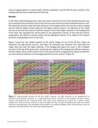
This area of the Peruvian Andes is geologically complex, yet has strong seismic signal quality. Even in
the footwall of the major thrust, we were able to interpret many structural details on the final seismic
images.
We took an interpretive approach to depth migration, creating a structural model over the entire block
so that the velocity structure could be consistent from line to line, avoiding the pitfall of creating
artificial velocity structures. We tested a variety of models, to avoid interpretation bias to the final
depth structures, and we found that the closure on the footwall structures is robust, and deviating
from our optimized model resulted in degradation of the seismic image.
The final interpretation of the block is integrated with the velocity model interpretation supported by
palynological data from the field and regional seismic correlations.
Acknowledgements
Gran Tierra Energy and Thrust Belt Imaging for permission to publish this work.
References
Espurt, N., Brusset S., Baby P., Hermoza W., Bolanos, R., Uyen, D. and J. Deramond, [2008] Paleozoic
structural controls on shortening transfer in the Subandean foreland thrust system, Ene and southern
Ucayali basins, Peru; Tectonics, Vol. 27, TC3009, doi: 0.1029/2007TC002238, 2008.
Hermoza, W., Baby, P., Espurt, N., Martinez, E. and R. Bolanos [2006] The Ucayali Subandean Bason: a
complex fold and thrust belt and inverted system; IX Simposio Bolivariano, Petroleum Exploration in
the Subandean Basins; Cartegena de las Indias, Columbia, Sept 2006.
Schultz, P. [1999] The Seismic Velocity Model as an Interpetation Asset. Soc. of Expl. Geophys.
Vestrum R.W., Lawton D.C. and Schmid R.S. [1999] Imaging structures below dipping TI media.
Geophysics 64, 1239–1246.
Vestrum, R.W., and Lawton, D.C. [2010] Reflection point sideslip and smear in imaging below dipping
anisotropic media. Geophysical Prospecting, 58, 541–548.](https://image.slidesharecdn.com/6f8870e9-89c0-4e79-9261-6b77513b5329-150130135154-conversion-gate01/85/_GC2014_Integration_of_Geologic_Data_into_Structural_Imaging-5-320.jpg)


