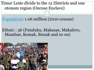
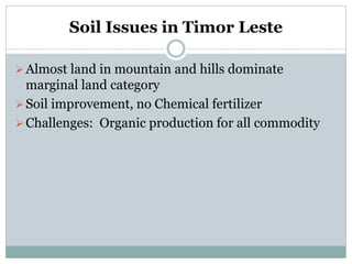
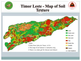
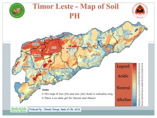
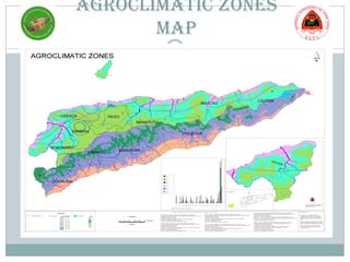
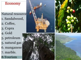
COUNTRY REPORT OF
EAST TIMOR
BY
Juliberto dos Santos
Rita da Costa da Soares
Timor Leste was known as East Timor. It was a Portuguese colony
during about 500 years (1515-1975), and annexed by Indonesia during
about 24 years (1975-1999). Timor Leste was internationally recognized
as an independent democratic state namely República Democrática De
Timor-Leste or Republic Democratic of Timor Leste since May 20th
2002.
The National Flag
* Yellow - the traces of colonialism in Timor-
Leste's history;
* Black - the obscurationism that needs to be
overcome;
* Red - the struggle for national liberation;
* White - peace.
Timor Leste divide to the 12 Districts and one
otonom region (Oecuse Enclave)
Population: 1.06 million (2010 census)
Ethnic : 36 (Fataluku, Makasae, Makalero,
Mambae, Kemak, Bunak and so on)
Soil Issues in Timor Leste
Almost land in mountain and hills dominate
marginal land category
Soil improvement, no Chemical fertilizer
Challenges: Organic production for all commodity
Notes:
Data from Solos de Timor, 1978
This map of soil texture is indicative only.
There is no data yet for Oecussi and Atauro
Timor Leste - Map of Soil
PH
Notes:
This map of iron (Fe) and zinc (Zn) levels is indicative only.
There is no data yet for Oecussi and Atauro
Legend
Acidic
Neutral
Alkaline
Timor Leste - Map of Fe and Zn
Deficiency
Notes:
This map of iron (Fe) and zinc (Zn) levels is indicative only.
There is no data yet for Oecussi and Atauro
Increased risk of
Fe and Zn Deficiency
HIDROGEOLOGY OF TIMOR
LESTE
Timor-Leste Map Soil Data
AGROCLIMATIC ZONES
MAP
Forest lowland 761,486 51
Forest highland, coastal and other 92,768 6
Agricultural estate crops 74,578 5
Agricultural food and other crops 336,400 23
Non-productive land 203,152 14
Cities, towns and villages 19,934 1
Lakes 5,080 0
Total 1,493,398 100
Land Use Category Distribution (%)Area (Ha)
Natural resources
1. Sandalwood,
2. Coffee,
3. Copra
4. Gold
5. petroleum
5. natural gas
6. manganese
7. marble.
8.Tourism
Thank you
Obrigado

Timor Leste

  • 1.
    COUNTRY REPORT OF EASTTIMOR BY Juliberto dos Santos Rita da Costa da Soares
  • 2.
    Timor Leste wasknown as East Timor. It was a Portuguese colony during about 500 years (1515-1975), and annexed by Indonesia during about 24 years (1975-1999). Timor Leste was internationally recognized as an independent democratic state namely República Democrática De Timor-Leste or Republic Democratic of Timor Leste since May 20th 2002.
  • 3.
    The National Flag *Yellow - the traces of colonialism in Timor- Leste's history; * Black - the obscurationism that needs to be overcome; * Red - the struggle for national liberation; * White - peace.
  • 4.
    Timor Leste divideto the 12 Districts and one otonom region (Oecuse Enclave) Population: 1.06 million (2010 census) Ethnic : 36 (Fataluku, Makasae, Makalero, Mambae, Kemak, Bunak and so on)
  • 5.
    Soil Issues inTimor Leste Almost land in mountain and hills dominate marginal land category Soil improvement, no Chemical fertilizer Challenges: Organic production for all commodity
  • 6.
    Notes: Data from Solosde Timor, 1978 This map of soil texture is indicative only. There is no data yet for Oecussi and Atauro
  • 7.
    Timor Leste -Map of Soil PH Notes: This map of iron (Fe) and zinc (Zn) levels is indicative only. There is no data yet for Oecussi and Atauro Legend Acidic Neutral Alkaline
  • 8.
    Timor Leste -Map of Fe and Zn Deficiency Notes: This map of iron (Fe) and zinc (Zn) levels is indicative only. There is no data yet for Oecussi and Atauro Increased risk of Fe and Zn Deficiency
  • 9.
  • 10.
  • 11.
  • 12.
    Forest lowland 761,48651 Forest highland, coastal and other 92,768 6 Agricultural estate crops 74,578 5 Agricultural food and other crops 336,400 23 Non-productive land 203,152 14 Cities, towns and villages 19,934 1 Lakes 5,080 0 Total 1,493,398 100 Land Use Category Distribution (%)Area (Ha)
  • 13.
    Natural resources 1. Sandalwood, 2.Coffee, 3. Copra 4. Gold 5. petroleum 5. natural gas 6. manganese 7. marble. 8.Tourism
  • 14.