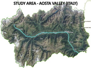
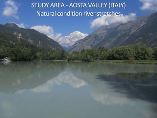
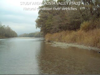
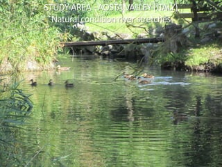
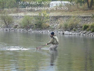
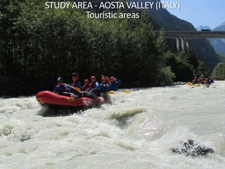
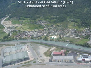
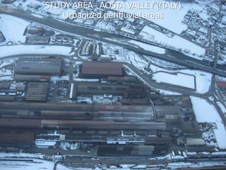
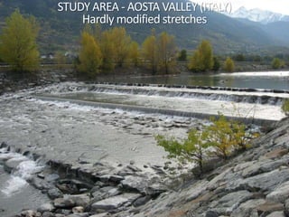
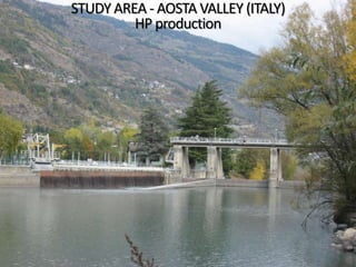
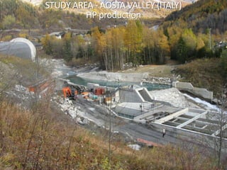
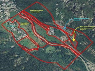
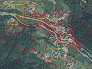
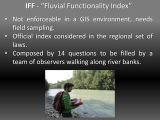
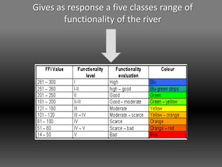
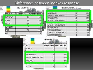
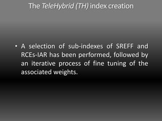
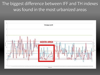
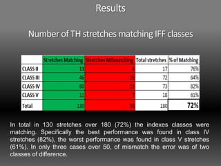
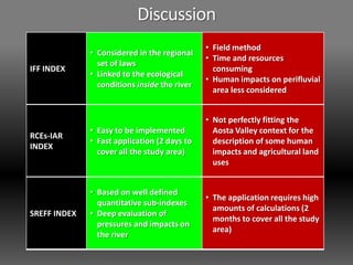
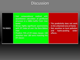
SlideShare a Scribd company logo
UNIVERSITÀDEGLI STUDI DI TORINO
THE USE OF INDEXES OF RIPARIAN VEGETATION STATUS
AND RIVER ECOLOGICAL FUNCTIONALITY TO SUPPORT
THE DORA BALTEA RIVER MANAGEMENT IN AOSTA
VALLEY (ITALY)
RELATORE: Prof.ssa Consolata Siniscalco
CO-RELATORE: Dott. Andrea Mammoliti Mochet (ARPA Valle d’Aosta)
CO-RELATORE: Dott. Giovanni Leonelli
Candidato: Mattia Ogliengo
Anno Accademico 2010 - 2011
STUDY AREA - AOSTA VALLEY (ITALY)
Natural condition river stretches
STUDY AREA - AOSTA VALLEY (ITALY)
Natural condition river stretches
STUDY AREA - AOSTA VALLEY (ITALY)
Natural condition river stretches
STUDY AREA - AOSTA VALLEY (ITALY)
Fishing and angling sectors
STUDY AREA - AOSTA VALLEY (ITALY)
Touristic areas
STUDY AREA - AOSTA VALLEY (ITALY)
Urbanized perifluvial areas
STUDY AREA - AOSTA VALLEY (ITALY)
Urbanized perifluvial areas
STUDY AREA - AOSTA VALLEY (ITALY)
Hardly modified stretches
STUDY AREA - AOSTA VALLEY (ITALY)
HP production
STUDY AREA - AOSTA VALLEY (ITALY)
HP production
Objectives of the thesis
1. Selection of methods able to assess the
natural capital represented by the Dora
Baltea river by aero photogrammetric
approach.
2. Determine which method fits better to IFF
index being less time and resources
consuming.
3. Define a new index (TH, TeleHybrid) based
on aero photogrammetric images and GIS
software.
Materials and methods
Indexes have been selected following the method
used by Abati and Leonelli (SHARE project, 2011)
in the “review of the most used and recent
methods at regional and local spatial scales”
• The index can be used in an Alpine context?
• Quantity of input data needed?
• Is it enforceable by an aerophotogrammetric
approach?
RCEs-IAR - “Riparian channel environment
simplified, human impacts on rivers”
• Composed by questions which evaluates both
the natural capital (RCE part) and the human
impacts (IAR part).
• The sum of the scores gives a 7 classes range of
river quality.
SREFF - “Method for the screening of the
ecosystem resources of the rivers”
• It is based on 5 sub indexes calculated in the
geo-informatic system concerning:
• the geo-morphology (Ig),
• the vegetation (Iv),
• the land cover (Ief) and the impacts (Iia)
on the perifluvial buffer,
• the modifications of the river bed (Ima).
The final evaluation is obtained by crossing the
state index and pressure index scores and it is
composed by a 10 classes degradation status.
IFF - “Fluvial Functionality Index”
• Not enforceable in a GIS environment, needs
field sampling.
• Official index considered in the regional set of
laws.
• Composed by 14 questions to be filled by a
team of observers walking along river banks.
Gives as response a five classes range of
functionality of the river
Results
• I.F.F. already available dataset (CVA spa)
has been completed by new sampling (44
stretches).
• S.R.E.F.F. and RCEs-IAR have been applied
in the same 180 IFF stretches.
• The limit scores of each class of the three
used indexes have been normalized and
graphically represented.
Results
RCEs-IAR INDEX
S.R.E.F.F. INDEX
IFF INDEX
RCEs-IAR INDEX S.R.E.F.F. INDEX
IFF INDEX
Differences between indexes response
RCEs-IAR INDEX S.R.E.F.F. INDEX
IFF INDEX
IFF N.STRETCHES % OF STRETCHES
II GOOD 12 7%
II-III GOOD-MODERATE 6 3%
III MODERATE 40 22%
III-IVMODERATE-SCARCE 27 15%
IV SCARCE 65 36%
IV-V SCARCE-BAD 24 13%
V BAD 6 3%
RCES-IAR N.STRETCHES %OFSTRETCHES
EXCELLENT 29 16%
GOOD 53 29%
DECENT 60 33%
SUFFICIENT 7 4%
POOR 30 17%
BAD 1 1%
SREFF N. STRETCHES % OF STRETCHES
NO DEGRADE 35 19%
INSIGNIFICANT DEGRADE 42 23%
LOW DEGRADE 21 12%
MEDIUM- LOW DEGRADE 29 16%
MEDIUMDEGRADE 13 7%
MEDIUM- HIGH DEGRADE 13 7%
HIGH DEGRADE 12 7%
VERY HIGH DEGRADE 5 3%
EXTREMELY HIGH DEGRADE 9 5%
MAXIMUMDEGRADE 1 1%
The TeleHybrid (TH) index creation
• A selection of sub-indexes of SREFF and
RCEs-IAR has been performed, followed by
an iterative process of fine tuning of the
associated weights.
SREFF INDEX
STATE
index
Ig Iv Ief
PRESSURE
index
Iia Ima
RCEs-IAR
INDEX
IAR
questions
1abc 2abc 3abc 4ab 5 6
RCE questions
1 2 3 4 5 6
TeleHybrid
(TH) index
The TeleHybrid (TH) index creation STEP 1
The TeleHybrid (TH) index creation STEP 2
Following first plotting of IFF and TH indexes
data, an upstream – downstream gradient of
differences between indexes was in evidence.
y= -0.1795x
• Monthly data of natural discharges have been
considered using datasets collected by 6
official monitoring stations over Dora Baltea.
The TeleHybrid (TH) index creation STEP 2
y= -0.001x
• Monthly data of natural discharges have been
considered using datasets collected by 6
official monitoring stations over Dora Baltea.
The TeleHybrid (TH) index creation STEP 2
ResultsTH INDEXIFF INDEX
ResultsTH INDEX
The biggest difference between IFF and TH indexes
was found in the most urbanized areas
AOSTA AREA
Results
Number of TH stretches matching IFF classes
In total in 130 stretches over 180 (72%) the indexes classes were
matching. Specifically the best performance was found in class IV
stretches (82%), the worst performance was found in class V stretches
(61%). In only three cases over 50, of mismatch the error was of two
classes of difference.
Discussion
IFF INDEX
• Considered in the regional
set of laws
• Linked to the ecological
conditions inside the river
• Field method
• Time and resources
consuming
• Human impacts on perifluvial
area less considered
RCEs-IAR
INDEX
• Easy to be implemented
• Fast application (2 days to
cover all the study area)
• Not perfectly fitting the
Aosta Valley context for the
description of some human
impacts and agricultural land
uses
SREFF INDEX
• Based on well defined
quantitative sub-indexes
• Deep evaluation of
pressures and impacts on
the river
• The application requires high
amounts of calculations (2
months to cover all the study
area)
TH INDEX
• Fast computational method with
quantitative calculation of perifluvial
structure in a 300m buffer from river
banks
• Shows highly significant synchronicity
with IFF index all over the Dora Baltea
river
• Predicts 72% of IFF index classes: 130
stretches over 180 were matching the
IFF classes
• The predictivity does not work
in the urbanized area of Aosta
• Not sensitive to local pollution
and hydro-peaking wider
effects.
Discussion
Conclusions
This work has shown that by means of a aero-
photogrammetric approach it is possible to assess
72% of the stretches values obtained from a field
based index such as IFF, meaning that these
indexes respond in a similar way to changes in the
river ecosystem quality.
• New data are required (for example the density of
hydrological works per stretch or other river
ecological parameters) in order to have good results
in different situations (e.g. the most urbanized areas).
• Additional parameters can be easily tested modifying
the TH index equation.
Conclusions
The TH index at this level of implementation
should be considered as a “beta version”.
Conclusions
• After further implementations TH index, could be
proposed as a new tool for river management in
the alpine context, being less time and resources
consuming than field based methods.
THANK YOU FOR YOUR ATTENTION

More Related Content

What's hot

The Development of a Catchment Management Modelling System for the Googong Re...
The Development of a Catchment Management Modelling System for the Googong Re...The Development of a Catchment Management Modelling System for the Googong Re...
The Development of a Catchment Management Modelling System for the Googong Re...
GavanThomas
 
Understanding impacts of sustainable land management interventions using SWAT...
Understanding impacts of sustainable land management interventions using SWAT...Understanding impacts of sustainable land management interventions using SWAT...
Understanding impacts of sustainable land management interventions using SWAT...
International Water Management Institute (IWMI)
 
Assessing the long-term water savings of reduced irrigation pumping in wester...
Assessing the long-term water savings of reduced irrigation pumping in wester...Assessing the long-term water savings of reduced irrigation pumping in wester...
Assessing the long-term water savings of reduced irrigation pumping in wester...
Daugherty Water for Food Global Institute
 
CV
CVCV
Effectiveness Analysis of Best Management Practices by SWAT for Appropriate C...
Effectiveness Analysis of Best Management Practices by SWAT for Appropriate C...Effectiveness Analysis of Best Management Practices by SWAT for Appropriate C...
Effectiveness Analysis of Best Management Practices by SWAT for Appropriate C...
ExternalEvents
 
Inspect typical water monitoring equipment alan hooper
Inspect typical water monitoring equipment alan hooperInspect typical water monitoring equipment alan hooper
Inspect typical water monitoring equipment alan hooperInternational WaterCentre
 
23 - NRSC - Remote Satellite Imgae - Hydrology and Water Management-Sep-17
23 - NRSC - Remote Satellite Imgae - Hydrology and Water Management-Sep-1723 - NRSC - Remote Satellite Imgae - Hydrology and Water Management-Sep-17
23 - NRSC - Remote Satellite Imgae - Hydrology and Water Management-Sep-17
indiawrm
 
WATER RESOURCES MODELING OF THE GANGES-BRAHMAPUTRA-MEGHNA RIVER BASINS USING ...
WATER RESOURCES MODELING OF THE GANGES-BRAHMAPUTRA-MEGHNA RIVER BASINS USING ...WATER RESOURCES MODELING OF THE GANGES-BRAHMAPUTRA-MEGHNA RIVER BASINS USING ...
WATER RESOURCES MODELING OF THE GANGES-BRAHMAPUTRA-MEGHNA RIVER BASINS USING ...
Moudud Hasan
 
Exploring environmental flow regimes in the lower sesan in cambodia
Exploring environmental flow regimes in the lower sesan in cambodiaExploring environmental flow regimes in the lower sesan in cambodia
Exploring environmental flow regimes in the lower sesan in cambodia
CPWF Mekong
 
Medição
MediçãoMedição
Medição
Danilo Menegassi
 
Swat model
Swat model Swat model
Swat model
vishvjeet tholia
 
Rehder, Gregor: Making Atmopheric measurements onboard SOOPs
Rehder, Gregor: Making Atmopheric measurements onboard SOOPsRehder, Gregor: Making Atmopheric measurements onboard SOOPs
Rehder, Gregor: Making Atmopheric measurements onboard SOOPs
Integrated Carbon Observation System (ICOS)
 
C5.06: Argo: Recent Insights and Future Evolution - Susan Wijffels
C5.06: Argo: Recent Insights and Future Evolution - Susan WijffelsC5.06: Argo: Recent Insights and Future Evolution - Susan Wijffels
C5.06: Argo: Recent Insights and Future Evolution - Susan Wijffels
Blue Planet Symposium
 
Reelfoot_AWRA_2015
Reelfoot_AWRA_2015Reelfoot_AWRA_2015
Reelfoot_AWRA_2015Brandon Cobb
 
Accounting soil moisture assimilation for hydrologic predictions
Accounting soil moisture assimilation for hydrologic predictionsAccounting soil moisture assimilation for hydrologic predictions
Accounting soil moisture assimilation for hydrologic predictions
Pawan Jeet
 
Jaya r pudashine
Jaya r pudashineJaya r pudashine
Jaya r pudashineClimDev15
 
REMOTE SENSING DATA FOR HYDROLOGICAL MODELING
REMOTE SENSING DATA FOR HYDROLOGICAL MODELINGREMOTE SENSING DATA FOR HYDROLOGICAL MODELING
REMOTE SENSING DATA FOR HYDROLOGICAL MODELING
Shyam Mohan Chaudhary
 
Ganga Environmental Flow Calculator and its Applications
Ganga Environmental Flow Calculator and its ApplicationsGanga Environmental Flow Calculator and its Applications
Ganga Environmental Flow Calculator and its Applications
International Water Management Institute (IWMI)
 
2016Fall_GSFC_NorthCarolinaWater_Poster_FD
2016Fall_GSFC_NorthCarolinaWater_Poster_FD2016Fall_GSFC_NorthCarolinaWater_Poster_FD
2016Fall_GSFC_NorthCarolinaWater_Poster_FDJohn Fitz
 

What's hot (20)

The Development of a Catchment Management Modelling System for the Googong Re...
The Development of a Catchment Management Modelling System for the Googong Re...The Development of a Catchment Management Modelling System for the Googong Re...
The Development of a Catchment Management Modelling System for the Googong Re...
 
Understanding impacts of sustainable land management interventions using SWAT...
Understanding impacts of sustainable land management interventions using SWAT...Understanding impacts of sustainable land management interventions using SWAT...
Understanding impacts of sustainable land management interventions using SWAT...
 
Assessing the long-term water savings of reduced irrigation pumping in wester...
Assessing the long-term water savings of reduced irrigation pumping in wester...Assessing the long-term water savings of reduced irrigation pumping in wester...
Assessing the long-term water savings of reduced irrigation pumping in wester...
 
CV
CVCV
CV
 
Effectiveness Analysis of Best Management Practices by SWAT for Appropriate C...
Effectiveness Analysis of Best Management Practices by SWAT for Appropriate C...Effectiveness Analysis of Best Management Practices by SWAT for Appropriate C...
Effectiveness Analysis of Best Management Practices by SWAT for Appropriate C...
 
Inspect typical water monitoring equipment alan hooper
Inspect typical water monitoring equipment alan hooperInspect typical water monitoring equipment alan hooper
Inspect typical water monitoring equipment alan hooper
 
23 - NRSC - Remote Satellite Imgae - Hydrology and Water Management-Sep-17
23 - NRSC - Remote Satellite Imgae - Hydrology and Water Management-Sep-1723 - NRSC - Remote Satellite Imgae - Hydrology and Water Management-Sep-17
23 - NRSC - Remote Satellite Imgae - Hydrology and Water Management-Sep-17
 
WATER RESOURCES MODELING OF THE GANGES-BRAHMAPUTRA-MEGHNA RIVER BASINS USING ...
WATER RESOURCES MODELING OF THE GANGES-BRAHMAPUTRA-MEGHNA RIVER BASINS USING ...WATER RESOURCES MODELING OF THE GANGES-BRAHMAPUTRA-MEGHNA RIVER BASINS USING ...
WATER RESOURCES MODELING OF THE GANGES-BRAHMAPUTRA-MEGHNA RIVER BASINS USING ...
 
GSA_2015_Scott1
GSA_2015_Scott1GSA_2015_Scott1
GSA_2015_Scott1
 
Exploring environmental flow regimes in the lower sesan in cambodia
Exploring environmental flow regimes in the lower sesan in cambodiaExploring environmental flow regimes in the lower sesan in cambodia
Exploring environmental flow regimes in the lower sesan in cambodia
 
Medição
MediçãoMedição
Medição
 
Swat model
Swat model Swat model
Swat model
 
Rehder, Gregor: Making Atmopheric measurements onboard SOOPs
Rehder, Gregor: Making Atmopheric measurements onboard SOOPsRehder, Gregor: Making Atmopheric measurements onboard SOOPs
Rehder, Gregor: Making Atmopheric measurements onboard SOOPs
 
C5.06: Argo: Recent Insights and Future Evolution - Susan Wijffels
C5.06: Argo: Recent Insights and Future Evolution - Susan WijffelsC5.06: Argo: Recent Insights and Future Evolution - Susan Wijffels
C5.06: Argo: Recent Insights and Future Evolution - Susan Wijffels
 
Reelfoot_AWRA_2015
Reelfoot_AWRA_2015Reelfoot_AWRA_2015
Reelfoot_AWRA_2015
 
Accounting soil moisture assimilation for hydrologic predictions
Accounting soil moisture assimilation for hydrologic predictionsAccounting soil moisture assimilation for hydrologic predictions
Accounting soil moisture assimilation for hydrologic predictions
 
Jaya r pudashine
Jaya r pudashineJaya r pudashine
Jaya r pudashine
 
REMOTE SENSING DATA FOR HYDROLOGICAL MODELING
REMOTE SENSING DATA FOR HYDROLOGICAL MODELINGREMOTE SENSING DATA FOR HYDROLOGICAL MODELING
REMOTE SENSING DATA FOR HYDROLOGICAL MODELING
 
Ganga Environmental Flow Calculator and its Applications
Ganga Environmental Flow Calculator and its ApplicationsGanga Environmental Flow Calculator and its Applications
Ganga Environmental Flow Calculator and its Applications
 
2016Fall_GSFC_NorthCarolinaWater_Poster_FD
2016Fall_GSFC_NorthCarolinaWater_Poster_FD2016Fall_GSFC_NorthCarolinaWater_Poster_FD
2016Fall_GSFC_NorthCarolinaWater_Poster_FD
 

Similar to The use of indexes of riparian vegetation status and river ecological functionality to support the Dora Baltea river management in Aosta Valley (Italy)

My-Presentation.pptx
My-Presentation.pptxMy-Presentation.pptx
My-Presentation.pptx
AbdusalamIdiris
 
Runoff estimation and water management for Holetta River, Awash subbasin, Eth...
Runoff estimation and water management for Holetta River, Awash subbasin, Eth...Runoff estimation and water management for Holetta River, Awash subbasin, Eth...
Runoff estimation and water management for Holetta River, Awash subbasin, Eth...
International Water Management Institute (IWMI)
 
IRJET- Rainfall-Runoff Analysis of the Watershed for River AIE
IRJET-  	  Rainfall-Runoff Analysis of the Watershed for River AIEIRJET-  	  Rainfall-Runoff Analysis of the Watershed for River AIE
IRJET- Rainfall-Runoff Analysis of the Watershed for River AIE
IRJET Journal
 
Water Quality Monitoring Programs in Fairfax County, April 2014
Water Quality Monitoring Programs in Fairfax County, April 2014Water Quality Monitoring Programs in Fairfax County, April 2014
Water Quality Monitoring Programs in Fairfax County, April 2014
Fairfax County
 
HYDROLOGICAL AND WATER QUALITY MODELLING USING SWAT FOR DONI RIVER
HYDROLOGICAL AND WATER QUALITY MODELLING USING SWAT FOR DONI RIVERHYDROLOGICAL AND WATER QUALITY MODELLING USING SWAT FOR DONI RIVER
HYDROLOGICAL AND WATER QUALITY MODELLING USING SWAT FOR DONI RIVER
IRJET Journal
 
J012415965
J012415965J012415965
J012415965
IOSR Journals
 
DSD-INT 2016 Regional groundwater flow systems in the Kenya Rift Valley - Mur...
DSD-INT 2016 Regional groundwater flow systems in the Kenya Rift Valley - Mur...DSD-INT 2016 Regional groundwater flow systems in the Kenya Rift Valley - Mur...
DSD-INT 2016 Regional groundwater flow systems in the Kenya Rift Valley - Mur...
Deltares
 
Modeling the hydrological regime of Turkana Lake (Kenya, Ethiopia) by combini...
Modeling the hydrological regime of Turkana Lake (Kenya, Ethiopia) by combini...Modeling the hydrological regime of Turkana Lake (Kenya, Ethiopia) by combini...
Modeling the hydrological regime of Turkana Lake (Kenya, Ethiopia) by combini...
DAFNE project
 
Monitoring NDTI-River Temperature relationship along the river ganga in the s...
Monitoring NDTI-River Temperature relationship along the river ganga in the s...Monitoring NDTI-River Temperature relationship along the river ganga in the s...
Monitoring NDTI-River Temperature relationship along the river ganga in the s...
IRJET Journal
 
SWaRMA_IRBM_Module2_#5, Role of hydrometeorological monitoring for IRBM in Ne...
SWaRMA_IRBM_Module2_#5, Role of hydrometeorological monitoring for IRBM in Ne...SWaRMA_IRBM_Module2_#5, Role of hydrometeorological monitoring for IRBM in Ne...
SWaRMA_IRBM_Module2_#5, Role of hydrometeorological monitoring for IRBM in Ne...
ICIMOD
 
Environmental flow & Fish passes
Environmental flow & Fish passesEnvironmental flow & Fish passes
Environmental flow & Fish passes
SHAHANAS6
 
Integration of the MODFLOW Lak7 package in the FREEWAT GIS modelling environment
Integration of the MODFLOW Lak7 package in the FREEWAT GIS modelling environmentIntegration of the MODFLOW Lak7 package in the FREEWAT GIS modelling environment
Integration of the MODFLOW Lak7 package in the FREEWAT GIS modelling environment
Massimiliano Cannata
 
Day 1 neno kukuric igrac - methodology
Day 1 neno kukuric   igrac - methodologyDay 1 neno kukuric   igrac - methodology
Day 1 neno kukuric igrac - methodology
groundwatercop
 
July 29-330-Dennis Flanagan
July 29-330-Dennis FlanaganJuly 29-330-Dennis Flanagan
July 29-330-Dennis Flanagan
Soil and Water Conservation Society
 
Coupling of Surface water and Groundwater Models
Coupling of Surface water and Groundwater Models Coupling of Surface water and Groundwater Models
Coupling of Surface water and Groundwater Models
TIPU SULTAN BADAGAN
 
DSD-INT 2019 The FEWSPo system - actual state and new developments - Tonelli
DSD-INT 2019 The FEWSPo system - actual state and new developments - TonelliDSD-INT 2019 The FEWSPo system - actual state and new developments - Tonelli
DSD-INT 2019 The FEWSPo system - actual state and new developments - Tonelli
Deltares
 
EcoTas13 BradEvans e-MAST
EcoTas13 BradEvans e-MASTEcoTas13 BradEvans e-MAST
EcoTas13 BradEvans e-MAST
TERN Australia
 
A framework to assess wetlands' potential as Nature-based Solutions
A framework to assess wetlands' potential as Nature-based SolutionsA framework to assess wetlands' potential as Nature-based Solutions
A framework to assess wetlands' potential as Nature-based Solutions
AngelosAlamanos
 
Download-manuals-surface water-manual-sw-volume3referencemanualhydro-meteoro...
 Download-manuals-surface water-manual-sw-volume3referencemanualhydro-meteoro... Download-manuals-surface water-manual-sw-volume3referencemanualhydro-meteoro...
Download-manuals-surface water-manual-sw-volume3referencemanualhydro-meteoro...hydrologyproject001
 

Similar to The use of indexes of riparian vegetation status and river ecological functionality to support the Dora Baltea river management in Aosta Valley (Italy) (20)

My-Presentation.pptx
My-Presentation.pptxMy-Presentation.pptx
My-Presentation.pptx
 
Runoff estimation and water management for Holetta River, Awash subbasin, Eth...
Runoff estimation and water management for Holetta River, Awash subbasin, Eth...Runoff estimation and water management for Holetta River, Awash subbasin, Eth...
Runoff estimation and water management for Holetta River, Awash subbasin, Eth...
 
IRJET- Rainfall-Runoff Analysis of the Watershed for River AIE
IRJET-  	  Rainfall-Runoff Analysis of the Watershed for River AIEIRJET-  	  Rainfall-Runoff Analysis of the Watershed for River AIE
IRJET- Rainfall-Runoff Analysis of the Watershed for River AIE
 
Water Quality Monitoring Programs in Fairfax County, April 2014
Water Quality Monitoring Programs in Fairfax County, April 2014Water Quality Monitoring Programs in Fairfax County, April 2014
Water Quality Monitoring Programs in Fairfax County, April 2014
 
HYDROLOGICAL AND WATER QUALITY MODELLING USING SWAT FOR DONI RIVER
HYDROLOGICAL AND WATER QUALITY MODELLING USING SWAT FOR DONI RIVERHYDROLOGICAL AND WATER QUALITY MODELLING USING SWAT FOR DONI RIVER
HYDROLOGICAL AND WATER QUALITY MODELLING USING SWAT FOR DONI RIVER
 
J012415965
J012415965J012415965
J012415965
 
test.pptx
test.pptxtest.pptx
test.pptx
 
DSD-INT 2016 Regional groundwater flow systems in the Kenya Rift Valley - Mur...
DSD-INT 2016 Regional groundwater flow systems in the Kenya Rift Valley - Mur...DSD-INT 2016 Regional groundwater flow systems in the Kenya Rift Valley - Mur...
DSD-INT 2016 Regional groundwater flow systems in the Kenya Rift Valley - Mur...
 
Modeling the hydrological regime of Turkana Lake (Kenya, Ethiopia) by combini...
Modeling the hydrological regime of Turkana Lake (Kenya, Ethiopia) by combini...Modeling the hydrological regime of Turkana Lake (Kenya, Ethiopia) by combini...
Modeling the hydrological regime of Turkana Lake (Kenya, Ethiopia) by combini...
 
Monitoring NDTI-River Temperature relationship along the river ganga in the s...
Monitoring NDTI-River Temperature relationship along the river ganga in the s...Monitoring NDTI-River Temperature relationship along the river ganga in the s...
Monitoring NDTI-River Temperature relationship along the river ganga in the s...
 
SWaRMA_IRBM_Module2_#5, Role of hydrometeorological monitoring for IRBM in Ne...
SWaRMA_IRBM_Module2_#5, Role of hydrometeorological monitoring for IRBM in Ne...SWaRMA_IRBM_Module2_#5, Role of hydrometeorological monitoring for IRBM in Ne...
SWaRMA_IRBM_Module2_#5, Role of hydrometeorological monitoring for IRBM in Ne...
 
Environmental flow & Fish passes
Environmental flow & Fish passesEnvironmental flow & Fish passes
Environmental flow & Fish passes
 
Integration of the MODFLOW Lak7 package in the FREEWAT GIS modelling environment
Integration of the MODFLOW Lak7 package in the FREEWAT GIS modelling environmentIntegration of the MODFLOW Lak7 package in the FREEWAT GIS modelling environment
Integration of the MODFLOW Lak7 package in the FREEWAT GIS modelling environment
 
Day 1 neno kukuric igrac - methodology
Day 1 neno kukuric   igrac - methodologyDay 1 neno kukuric   igrac - methodology
Day 1 neno kukuric igrac - methodology
 
July 29-330-Dennis Flanagan
July 29-330-Dennis FlanaganJuly 29-330-Dennis Flanagan
July 29-330-Dennis Flanagan
 
Coupling of Surface water and Groundwater Models
Coupling of Surface water and Groundwater Models Coupling of Surface water and Groundwater Models
Coupling of Surface water and Groundwater Models
 
DSD-INT 2019 The FEWSPo system - actual state and new developments - Tonelli
DSD-INT 2019 The FEWSPo system - actual state and new developments - TonelliDSD-INT 2019 The FEWSPo system - actual state and new developments - Tonelli
DSD-INT 2019 The FEWSPo system - actual state and new developments - Tonelli
 
EcoTas13 BradEvans e-MAST
EcoTas13 BradEvans e-MASTEcoTas13 BradEvans e-MAST
EcoTas13 BradEvans e-MAST
 
A framework to assess wetlands' potential as Nature-based Solutions
A framework to assess wetlands' potential as Nature-based SolutionsA framework to assess wetlands' potential as Nature-based Solutions
A framework to assess wetlands' potential as Nature-based Solutions
 
Download-manuals-surface water-manual-sw-volume3referencemanualhydro-meteoro...
 Download-manuals-surface water-manual-sw-volume3referencemanualhydro-meteoro... Download-manuals-surface water-manual-sw-volume3referencemanualhydro-meteoro...
Download-manuals-surface water-manual-sw-volume3referencemanualhydro-meteoro...
 

Recently uploaded

Communications Mining Series - Zero to Hero - Session 1
Communications Mining Series - Zero to Hero - Session 1Communications Mining Series - Zero to Hero - Session 1
Communications Mining Series - Zero to Hero - Session 1
DianaGray10
 
PCI PIN Basics Webinar from the Controlcase Team
PCI PIN Basics Webinar from the Controlcase TeamPCI PIN Basics Webinar from the Controlcase Team
PCI PIN Basics Webinar from the Controlcase Team
ControlCase
 
UiPath Test Automation using UiPath Test Suite series, part 4
UiPath Test Automation using UiPath Test Suite series, part 4UiPath Test Automation using UiPath Test Suite series, part 4
UiPath Test Automation using UiPath Test Suite series, part 4
DianaGray10
 
UiPath Test Automation using UiPath Test Suite series, part 5
UiPath Test Automation using UiPath Test Suite series, part 5UiPath Test Automation using UiPath Test Suite series, part 5
UiPath Test Automation using UiPath Test Suite series, part 5
DianaGray10
 
Pushing the limits of ePRTC: 100ns holdover for 100 days
Pushing the limits of ePRTC: 100ns holdover for 100 daysPushing the limits of ePRTC: 100ns holdover for 100 days
Pushing the limits of ePRTC: 100ns holdover for 100 days
Adtran
 
Essentials of Automations: The Art of Triggers and Actions in FME
Essentials of Automations: The Art of Triggers and Actions in FMEEssentials of Automations: The Art of Triggers and Actions in FME
Essentials of Automations: The Art of Triggers and Actions in FME
Safe Software
 
Securing your Kubernetes cluster_ a step-by-step guide to success !
Securing your Kubernetes cluster_ a step-by-step guide to success !Securing your Kubernetes cluster_ a step-by-step guide to success !
Securing your Kubernetes cluster_ a step-by-step guide to success !
KatiaHIMEUR1
 
Video Streaming: Then, Now, and in the Future
Video Streaming: Then, Now, and in the FutureVideo Streaming: Then, Now, and in the Future
Video Streaming: Then, Now, and in the Future
Alpen-Adria-Universität
 
GraphSummit Singapore | Enhancing Changi Airport Group's Passenger Experience...
GraphSummit Singapore | Enhancing Changi Airport Group's Passenger Experience...GraphSummit Singapore | Enhancing Changi Airport Group's Passenger Experience...
GraphSummit Singapore | Enhancing Changi Airport Group's Passenger Experience...
Neo4j
 
20240607 QFM018 Elixir Reading List May 2024
20240607 QFM018 Elixir Reading List May 202420240607 QFM018 Elixir Reading List May 2024
20240607 QFM018 Elixir Reading List May 2024
Matthew Sinclair
 
FIDO Alliance Osaka Seminar: Passkeys at Amazon.pdf
FIDO Alliance Osaka Seminar: Passkeys at Amazon.pdfFIDO Alliance Osaka Seminar: Passkeys at Amazon.pdf
FIDO Alliance Osaka Seminar: Passkeys at Amazon.pdf
FIDO Alliance
 
Elevating Tactical DDD Patterns Through Object Calisthenics
Elevating Tactical DDD Patterns Through Object CalisthenicsElevating Tactical DDD Patterns Through Object Calisthenics
Elevating Tactical DDD Patterns Through Object Calisthenics
Dorra BARTAGUIZ
 
LF Energy Webinar: Electrical Grid Modelling and Simulation Through PowSyBl -...
LF Energy Webinar: Electrical Grid Modelling and Simulation Through PowSyBl -...LF Energy Webinar: Electrical Grid Modelling and Simulation Through PowSyBl -...
LF Energy Webinar: Electrical Grid Modelling and Simulation Through PowSyBl -...
DanBrown980551
 
The Future of Platform Engineering
The Future of Platform EngineeringThe Future of Platform Engineering
The Future of Platform Engineering
Jemma Hussein Allen
 
GDG Cloud Southlake #33: Boule & Rebala: Effective AppSec in SDLC using Deplo...
GDG Cloud Southlake #33: Boule & Rebala: Effective AppSec in SDLC using Deplo...GDG Cloud Southlake #33: Boule & Rebala: Effective AppSec in SDLC using Deplo...
GDG Cloud Southlake #33: Boule & Rebala: Effective AppSec in SDLC using Deplo...
James Anderson
 
By Design, not by Accident - Agile Venture Bolzano 2024
By Design, not by Accident - Agile Venture Bolzano 2024By Design, not by Accident - Agile Venture Bolzano 2024
By Design, not by Accident - Agile Venture Bolzano 2024
Pierluigi Pugliese
 
Removing Uninteresting Bytes in Software Fuzzing
Removing Uninteresting Bytes in Software FuzzingRemoving Uninteresting Bytes in Software Fuzzing
Removing Uninteresting Bytes in Software Fuzzing
Aftab Hussain
 
GraphRAG is All You need? LLM & Knowledge Graph
GraphRAG is All You need? LLM & Knowledge GraphGraphRAG is All You need? LLM & Knowledge Graph
GraphRAG is All You need? LLM & Knowledge Graph
Guy Korland
 
PHP Frameworks: I want to break free (IPC Berlin 2024)
PHP Frameworks: I want to break free (IPC Berlin 2024)PHP Frameworks: I want to break free (IPC Berlin 2024)
PHP Frameworks: I want to break free (IPC Berlin 2024)
Ralf Eggert
 
Transcript: Selling digital books in 2024: Insights from industry leaders - T...
Transcript: Selling digital books in 2024: Insights from industry leaders - T...Transcript: Selling digital books in 2024: Insights from industry leaders - T...
Transcript: Selling digital books in 2024: Insights from industry leaders - T...
BookNet Canada
 

Recently uploaded (20)

Communications Mining Series - Zero to Hero - Session 1
Communications Mining Series - Zero to Hero - Session 1Communications Mining Series - Zero to Hero - Session 1
Communications Mining Series - Zero to Hero - Session 1
 
PCI PIN Basics Webinar from the Controlcase Team
PCI PIN Basics Webinar from the Controlcase TeamPCI PIN Basics Webinar from the Controlcase Team
PCI PIN Basics Webinar from the Controlcase Team
 
UiPath Test Automation using UiPath Test Suite series, part 4
UiPath Test Automation using UiPath Test Suite series, part 4UiPath Test Automation using UiPath Test Suite series, part 4
UiPath Test Automation using UiPath Test Suite series, part 4
 
UiPath Test Automation using UiPath Test Suite series, part 5
UiPath Test Automation using UiPath Test Suite series, part 5UiPath Test Automation using UiPath Test Suite series, part 5
UiPath Test Automation using UiPath Test Suite series, part 5
 
Pushing the limits of ePRTC: 100ns holdover for 100 days
Pushing the limits of ePRTC: 100ns holdover for 100 daysPushing the limits of ePRTC: 100ns holdover for 100 days
Pushing the limits of ePRTC: 100ns holdover for 100 days
 
Essentials of Automations: The Art of Triggers and Actions in FME
Essentials of Automations: The Art of Triggers and Actions in FMEEssentials of Automations: The Art of Triggers and Actions in FME
Essentials of Automations: The Art of Triggers and Actions in FME
 
Securing your Kubernetes cluster_ a step-by-step guide to success !
Securing your Kubernetes cluster_ a step-by-step guide to success !Securing your Kubernetes cluster_ a step-by-step guide to success !
Securing your Kubernetes cluster_ a step-by-step guide to success !
 
Video Streaming: Then, Now, and in the Future
Video Streaming: Then, Now, and in the FutureVideo Streaming: Then, Now, and in the Future
Video Streaming: Then, Now, and in the Future
 
GraphSummit Singapore | Enhancing Changi Airport Group's Passenger Experience...
GraphSummit Singapore | Enhancing Changi Airport Group's Passenger Experience...GraphSummit Singapore | Enhancing Changi Airport Group's Passenger Experience...
GraphSummit Singapore | Enhancing Changi Airport Group's Passenger Experience...
 
20240607 QFM018 Elixir Reading List May 2024
20240607 QFM018 Elixir Reading List May 202420240607 QFM018 Elixir Reading List May 2024
20240607 QFM018 Elixir Reading List May 2024
 
FIDO Alliance Osaka Seminar: Passkeys at Amazon.pdf
FIDO Alliance Osaka Seminar: Passkeys at Amazon.pdfFIDO Alliance Osaka Seminar: Passkeys at Amazon.pdf
FIDO Alliance Osaka Seminar: Passkeys at Amazon.pdf
 
Elevating Tactical DDD Patterns Through Object Calisthenics
Elevating Tactical DDD Patterns Through Object CalisthenicsElevating Tactical DDD Patterns Through Object Calisthenics
Elevating Tactical DDD Patterns Through Object Calisthenics
 
LF Energy Webinar: Electrical Grid Modelling and Simulation Through PowSyBl -...
LF Energy Webinar: Electrical Grid Modelling and Simulation Through PowSyBl -...LF Energy Webinar: Electrical Grid Modelling and Simulation Through PowSyBl -...
LF Energy Webinar: Electrical Grid Modelling and Simulation Through PowSyBl -...
 
The Future of Platform Engineering
The Future of Platform EngineeringThe Future of Platform Engineering
The Future of Platform Engineering
 
GDG Cloud Southlake #33: Boule & Rebala: Effective AppSec in SDLC using Deplo...
GDG Cloud Southlake #33: Boule & Rebala: Effective AppSec in SDLC using Deplo...GDG Cloud Southlake #33: Boule & Rebala: Effective AppSec in SDLC using Deplo...
GDG Cloud Southlake #33: Boule & Rebala: Effective AppSec in SDLC using Deplo...
 
By Design, not by Accident - Agile Venture Bolzano 2024
By Design, not by Accident - Agile Venture Bolzano 2024By Design, not by Accident - Agile Venture Bolzano 2024
By Design, not by Accident - Agile Venture Bolzano 2024
 
Removing Uninteresting Bytes in Software Fuzzing
Removing Uninteresting Bytes in Software FuzzingRemoving Uninteresting Bytes in Software Fuzzing
Removing Uninteresting Bytes in Software Fuzzing
 
GraphRAG is All You need? LLM & Knowledge Graph
GraphRAG is All You need? LLM & Knowledge GraphGraphRAG is All You need? LLM & Knowledge Graph
GraphRAG is All You need? LLM & Knowledge Graph
 
PHP Frameworks: I want to break free (IPC Berlin 2024)
PHP Frameworks: I want to break free (IPC Berlin 2024)PHP Frameworks: I want to break free (IPC Berlin 2024)
PHP Frameworks: I want to break free (IPC Berlin 2024)
 
Transcript: Selling digital books in 2024: Insights from industry leaders - T...
Transcript: Selling digital books in 2024: Insights from industry leaders - T...Transcript: Selling digital books in 2024: Insights from industry leaders - T...
Transcript: Selling digital books in 2024: Insights from industry leaders - T...
 

The use of indexes of riparian vegetation status and river ecological functionality to support the Dora Baltea river management in Aosta Valley (Italy)

  • 1. UNIVERSITÀDEGLI STUDI DI TORINO THE USE OF INDEXES OF RIPARIAN VEGETATION STATUS AND RIVER ECOLOGICAL FUNCTIONALITY TO SUPPORT THE DORA BALTEA RIVER MANAGEMENT IN AOSTA VALLEY (ITALY) RELATORE: Prof.ssa Consolata Siniscalco CO-RELATORE: Dott. Andrea Mammoliti Mochet (ARPA Valle d’Aosta) CO-RELATORE: Dott. Giovanni Leonelli Candidato: Mattia Ogliengo Anno Accademico 2010 - 2011
  • 2. STUDY AREA - AOSTA VALLEY (ITALY)
  • 3. STUDY AREA - AOSTA VALLEY (ITALY) Natural condition river stretches
  • 4. STUDY AREA - AOSTA VALLEY (ITALY) Natural condition river stretches
  • 5. STUDY AREA - AOSTA VALLEY (ITALY) Natural condition river stretches
  • 6. STUDY AREA - AOSTA VALLEY (ITALY) Fishing and angling sectors
  • 7. STUDY AREA - AOSTA VALLEY (ITALY) Touristic areas
  • 8. STUDY AREA - AOSTA VALLEY (ITALY) Urbanized perifluvial areas
  • 9. STUDY AREA - AOSTA VALLEY (ITALY) Urbanized perifluvial areas
  • 10. STUDY AREA - AOSTA VALLEY (ITALY) Hardly modified stretches
  • 11. STUDY AREA - AOSTA VALLEY (ITALY) HP production
  • 12. STUDY AREA - AOSTA VALLEY (ITALY) HP production
  • 13. Objectives of the thesis 1. Selection of methods able to assess the natural capital represented by the Dora Baltea river by aero photogrammetric approach. 2. Determine which method fits better to IFF index being less time and resources consuming. 3. Define a new index (TH, TeleHybrid) based on aero photogrammetric images and GIS software.
  • 14. Materials and methods Indexes have been selected following the method used by Abati and Leonelli (SHARE project, 2011) in the “review of the most used and recent methods at regional and local spatial scales” • The index can be used in an Alpine context? • Quantity of input data needed? • Is it enforceable by an aerophotogrammetric approach?
  • 15. RCEs-IAR - “Riparian channel environment simplified, human impacts on rivers” • Composed by questions which evaluates both the natural capital (RCE part) and the human impacts (IAR part). • The sum of the scores gives a 7 classes range of river quality.
  • 16. SREFF - “Method for the screening of the ecosystem resources of the rivers” • It is based on 5 sub indexes calculated in the geo-informatic system concerning: • the geo-morphology (Ig), • the vegetation (Iv), • the land cover (Ief) and the impacts (Iia) on the perifluvial buffer, • the modifications of the river bed (Ima).
  • 17.
  • 18.
  • 19. The final evaluation is obtained by crossing the state index and pressure index scores and it is composed by a 10 classes degradation status.
  • 20. IFF - “Fluvial Functionality Index” • Not enforceable in a GIS environment, needs field sampling. • Official index considered in the regional set of laws. • Composed by 14 questions to be filled by a team of observers walking along river banks.
  • 21. Gives as response a five classes range of functionality of the river
  • 22. Results • I.F.F. already available dataset (CVA spa) has been completed by new sampling (44 stretches). • S.R.E.F.F. and RCEs-IAR have been applied in the same 180 IFF stretches. • The limit scores of each class of the three used indexes have been normalized and graphically represented.
  • 27. RCEs-IAR INDEX S.R.E.F.F. INDEX IFF INDEX
  • 28. Differences between indexes response RCEs-IAR INDEX S.R.E.F.F. INDEX IFF INDEX IFF N.STRETCHES % OF STRETCHES II GOOD 12 7% II-III GOOD-MODERATE 6 3% III MODERATE 40 22% III-IVMODERATE-SCARCE 27 15% IV SCARCE 65 36% IV-V SCARCE-BAD 24 13% V BAD 6 3% RCES-IAR N.STRETCHES %OFSTRETCHES EXCELLENT 29 16% GOOD 53 29% DECENT 60 33% SUFFICIENT 7 4% POOR 30 17% BAD 1 1% SREFF N. STRETCHES % OF STRETCHES NO DEGRADE 35 19% INSIGNIFICANT DEGRADE 42 23% LOW DEGRADE 21 12% MEDIUM- LOW DEGRADE 29 16% MEDIUMDEGRADE 13 7% MEDIUM- HIGH DEGRADE 13 7% HIGH DEGRADE 12 7% VERY HIGH DEGRADE 5 3% EXTREMELY HIGH DEGRADE 9 5% MAXIMUMDEGRADE 1 1%
  • 29. The TeleHybrid (TH) index creation • A selection of sub-indexes of SREFF and RCEs-IAR has been performed, followed by an iterative process of fine tuning of the associated weights.
  • 30. SREFF INDEX STATE index Ig Iv Ief PRESSURE index Iia Ima RCEs-IAR INDEX IAR questions 1abc 2abc 3abc 4ab 5 6 RCE questions 1 2 3 4 5 6 TeleHybrid (TH) index The TeleHybrid (TH) index creation STEP 1
  • 31. The TeleHybrid (TH) index creation STEP 2 Following first plotting of IFF and TH indexes data, an upstream – downstream gradient of differences between indexes was in evidence. y= -0.1795x
  • 32. • Monthly data of natural discharges have been considered using datasets collected by 6 official monitoring stations over Dora Baltea. The TeleHybrid (TH) index creation STEP 2
  • 33. y= -0.001x • Monthly data of natural discharges have been considered using datasets collected by 6 official monitoring stations over Dora Baltea. The TeleHybrid (TH) index creation STEP 2
  • 36. The biggest difference between IFF and TH indexes was found in the most urbanized areas AOSTA AREA
  • 37. Results Number of TH stretches matching IFF classes In total in 130 stretches over 180 (72%) the indexes classes were matching. Specifically the best performance was found in class IV stretches (82%), the worst performance was found in class V stretches (61%). In only three cases over 50, of mismatch the error was of two classes of difference.
  • 38. Discussion IFF INDEX • Considered in the regional set of laws • Linked to the ecological conditions inside the river • Field method • Time and resources consuming • Human impacts on perifluvial area less considered RCEs-IAR INDEX • Easy to be implemented • Fast application (2 days to cover all the study area) • Not perfectly fitting the Aosta Valley context for the description of some human impacts and agricultural land uses SREFF INDEX • Based on well defined quantitative sub-indexes • Deep evaluation of pressures and impacts on the river • The application requires high amounts of calculations (2 months to cover all the study area)
  • 39. TH INDEX • Fast computational method with quantitative calculation of perifluvial structure in a 300m buffer from river banks • Shows highly significant synchronicity with IFF index all over the Dora Baltea river • Predicts 72% of IFF index classes: 130 stretches over 180 were matching the IFF classes • The predictivity does not work in the urbanized area of Aosta • Not sensitive to local pollution and hydro-peaking wider effects. Discussion
  • 40. Conclusions This work has shown that by means of a aero- photogrammetric approach it is possible to assess 72% of the stretches values obtained from a field based index such as IFF, meaning that these indexes respond in a similar way to changes in the river ecosystem quality.
  • 41. • New data are required (for example the density of hydrological works per stretch or other river ecological parameters) in order to have good results in different situations (e.g. the most urbanized areas). • Additional parameters can be easily tested modifying the TH index equation. Conclusions The TH index at this level of implementation should be considered as a “beta version”.
  • 42. Conclusions • After further implementations TH index, could be proposed as a new tool for river management in the alpine context, being less time and resources consuming than field based methods.
  • 43. THANK YOU FOR YOUR ATTENTION