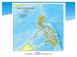
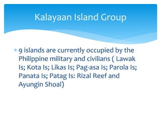
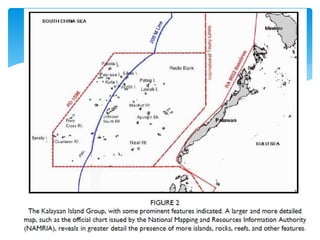
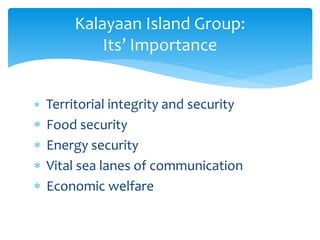
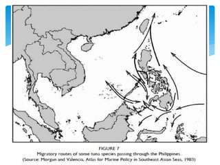
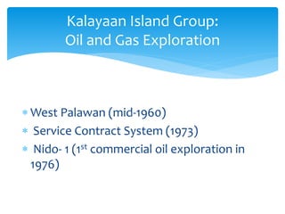
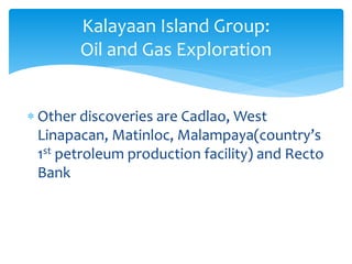
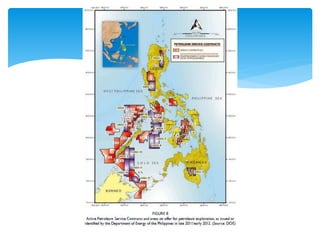
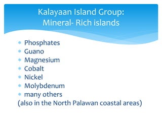
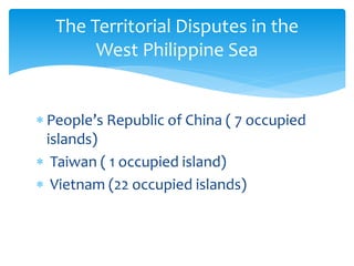
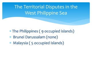
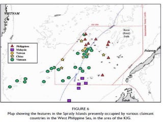
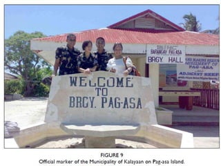
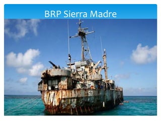
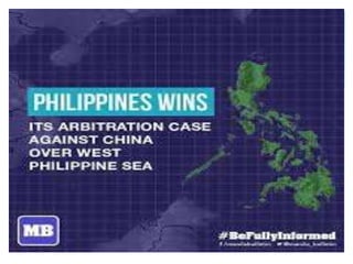
 UNCLOS – United Nation Convention
on the Law of the Sea
 KIG – Kalayaan Island Group
 WPS – West Philippine Sea
 SCS – South China Sea
Definition of Terms
 The WPS is a part of the SCS that is
closest to the Philippines.
 On Sept. 12 2012, Pres. Aquino III issued
the Administrative Order No. 29, with
Section 1 stating,
“ maritime areas on the west side of
the PHL archipelago are hereby
named as the West Philippine Sea”
The West Philippine Sea
 The South China Sea is much broader
expanse of water often describe as a semi-
enclosed sea, bounded by
 China/Taiwan(north),
 PHL(east),
 Viet Nam, Malaysia, Singapore &
Brunei(west)
 Indonesia(south)
The South China Sea
 Composed of 50 island
 Incorporated as a municipality of
Palawan in 1978 through the
Presidential Decree No. 1596
Kalayaan Island Group
 9 islands are currently occupied by the
Philippine military and civilians ( Lawak
Is; Kota Is; Likas Is; Pag-asa Is; Parola Is;
Panata Is; Patag Is: Rizal Reef and
Ayungin Shoal)
Kalayaan Island Group
 Territorial integrity and security
 Food security
 Energy security
 Vital sea lanes of communication
 Economic welfare
Kalayaan Island Group:
Its’ Importance
 West Palawan (mid-1960)
 Service Contract System (1973)
 Nido- 1 (1st commercial oil exploration in
1976)
Kalayaan Island Group:
Oil and Gas Exploration
 Other discoveries are Cadlao, West
Linapacan, Matinloc, Malampaya(country’s
1st petroleum production facility) and Recto
Bank
Kalayaan Island Group:
Oil and Gas Exploration
 Lack of investment
 Poor access to technology
 Bureaucratic Red Tape
 Tensions over the unresolved territorial
and maritime disputes
 Governance
Philippines’ hinders for more
petroleum exploration
 Phosphates
 Guano
 Magnesium
 Cobalt
 Nickel
 Molybdenum
 many others
(also in the North Palawan coastal areas)
Kalayaan Island Group:
Mineral- Rich islands
 People’s Republic of China ( 7 occupied
islands)
 Taiwan ( 1 occupied island)
 Vietnam (22 occupied islands)
The Territorial Disputes in the
West Philippine Sea
 The Philippines ( 9 occupied islands)
 Brunei Darussalam (none)
 Malaysia ( 5 occupied islands)
The Territorial Disputes in the
West Philippine Sea
 Sea Lines of Communications (SLOCs)
 United States of America’s military
activities
The Territorial Disputes in the
West Philippine Sea
 1933, Isabelo de los Reyes proposed the
inclusion of 9 biggest island as a part of
the transition.
History and Development
 1937, Interior Sec. Elpidio Quirino filed a
claim on the Philippines’ behalf citing
national defense and geographical
proximity as grounds
History and Development
 1946, Foreign affairs Sec. Quirino send a
letter to Gen Douglas McArthur stressing
the PHLs’ interest to KIG
History and Development
 1947, Quirino’s successor, Carlos P. Garcia,
demanded that the features be turned over
to the Government
History and Development
 1948, Tomas Cloma claimed to have found
the islands unoccupied.
History and Development
 1956, Cloma led a 38-day expedition
to KIG.
 1968, Philippines started sending
military troops
History and Development
1971, Pres. Ferdinand Marcos
announced the occupation on
several islands for national security
and to protect the interest of the
state and it’s citizen
History and Development
Economic Concerns
Security Concerns
Kalayaan Island Group
during Marcos Administration
 1970, Philippine posted troops on Lawak
Island
 1971, Philippine occupied, Kota,Likas,
Pag-asa and Parola
Start of Occupation on KIG
 In Pag-asa Is., established weather
station (1979), fishery research unit and
laboratory, runway for logistic support
aircraft, air force unit, naval station and
lighthouse (1993)
Start of Occupation on KIG
 Early 1995, China’s occupation on Panganiban
(Mischief) Reef send tension to Manila and
Beijing
Philippines’ battle for territory
 May 1995, a standoff happened between
Philippine Navy ship and two Chinese fishing
vessels back-up by a PLA-Navy Frigates
Philippines’ battle for territory
 March 2011, Philippine petroleum exploration
vessel was harassed by two Chinese vessel
Philippines’ battle for territory
 Signed on August 1995, to relieve the tension
between the two countries
 1998, China’s ‘Fisherman’s Shelters’ turned to a
‘Fortified military garrison’
 Action resulted to renewed security ties to US
military
Joint statement on the South China
Sea and Other Area of Cooperation
 Philippine Navy’s BRP Sierra Madre stationed
on Ayungin Shoal
 protest against increased Chinese presence
near Ayungin Shoal in March 2013
Recent Government Action
BRP Sierra Madre
Thank you!!!
 1968, Economic Commission for Asia and the
Far East reported that the South China Sea’s
continental shelf may contain oil and gas
deposits
 Claimants unilaterally drawn maritime
boundaries which is overlapping
 Claimants also deployed troops on various
maritime features
Economic Concerns
 Vietnam, Malaysia and Indonesia began
offshore exploration for petroleum reserves
 1976, after 80 years, oil was discovered in the
offshore Northwest Palawan.
Economic Concerns
1971, Taiwan troops on Ligaw (Itu Aba/
Taiping) island reported to have fired on a boat
carrying Philippine Congressman Ramon Mitra
Security Concerns

The West Philippine Sea

  • 1.
     UNCLOS –United Nation Convention on the Law of the Sea  KIG – Kalayaan Island Group  WPS – West Philippine Sea  SCS – South China Sea Definition of Terms
  • 2.
     The WPSis a part of the SCS that is closest to the Philippines.  On Sept. 12 2012, Pres. Aquino III issued the Administrative Order No. 29, with Section 1 stating, “ maritime areas on the west side of the PHL archipelago are hereby named as the West Philippine Sea” The West Philippine Sea
  • 3.
     The SouthChina Sea is much broader expanse of water often describe as a semi- enclosed sea, bounded by  China/Taiwan(north),  PHL(east),  Viet Nam, Malaysia, Singapore & Brunei(west)  Indonesia(south) The South China Sea
  • 5.
     Composed of50 island  Incorporated as a municipality of Palawan in 1978 through the Presidential Decree No. 1596 Kalayaan Island Group
  • 6.
     9 islandsare currently occupied by the Philippine military and civilians ( Lawak Is; Kota Is; Likas Is; Pag-asa Is; Parola Is; Panata Is; Patag Is: Rizal Reef and Ayungin Shoal) Kalayaan Island Group
  • 8.
     Territorial integrityand security  Food security  Energy security  Vital sea lanes of communication  Economic welfare Kalayaan Island Group: Its’ Importance
  • 10.
     West Palawan(mid-1960)  Service Contract System (1973)  Nido- 1 (1st commercial oil exploration in 1976) Kalayaan Island Group: Oil and Gas Exploration
  • 11.
     Other discoveriesare Cadlao, West Linapacan, Matinloc, Malampaya(country’s 1st petroleum production facility) and Recto Bank Kalayaan Island Group: Oil and Gas Exploration
  • 13.
     Lack ofinvestment  Poor access to technology  Bureaucratic Red Tape  Tensions over the unresolved territorial and maritime disputes  Governance Philippines’ hinders for more petroleum exploration
  • 14.
     Phosphates  Guano Magnesium  Cobalt  Nickel  Molybdenum  many others (also in the North Palawan coastal areas) Kalayaan Island Group: Mineral- Rich islands
  • 15.
     People’s Republicof China ( 7 occupied islands)  Taiwan ( 1 occupied island)  Vietnam (22 occupied islands) The Territorial Disputes in the West Philippine Sea
  • 16.
     The Philippines( 9 occupied islands)  Brunei Darussalam (none)  Malaysia ( 5 occupied islands) The Territorial Disputes in the West Philippine Sea
  • 19.
     Sea Linesof Communications (SLOCs)  United States of America’s military activities The Territorial Disputes in the West Philippine Sea
  • 21.
     1933, Isabelode los Reyes proposed the inclusion of 9 biggest island as a part of the transition. History and Development
  • 22.
     1937, InteriorSec. Elpidio Quirino filed a claim on the Philippines’ behalf citing national defense and geographical proximity as grounds History and Development
  • 23.
     1946, Foreignaffairs Sec. Quirino send a letter to Gen Douglas McArthur stressing the PHLs’ interest to KIG History and Development
  • 24.
     1947, Quirino’ssuccessor, Carlos P. Garcia, demanded that the features be turned over to the Government History and Development
  • 25.
     1948, TomasCloma claimed to have found the islands unoccupied. History and Development
  • 26.
     1956, Clomaled a 38-day expedition to KIG.  1968, Philippines started sending military troops History and Development
  • 27.
    1971, Pres. FerdinandMarcos announced the occupation on several islands for national security and to protect the interest of the state and it’s citizen History and Development
  • 28.
    Economic Concerns Security Concerns KalayaanIsland Group during Marcos Administration
  • 29.
     1970, Philippineposted troops on Lawak Island  1971, Philippine occupied, Kota,Likas, Pag-asa and Parola Start of Occupation on KIG
  • 30.
     In Pag-asaIs., established weather station (1979), fishery research unit and laboratory, runway for logistic support aircraft, air force unit, naval station and lighthouse (1993) Start of Occupation on KIG
  • 32.
     Early 1995,China’s occupation on Panganiban (Mischief) Reef send tension to Manila and Beijing Philippines’ battle for territory
  • 33.
     May 1995,a standoff happened between Philippine Navy ship and two Chinese fishing vessels back-up by a PLA-Navy Frigates Philippines’ battle for territory
  • 34.
     March 2011,Philippine petroleum exploration vessel was harassed by two Chinese vessel Philippines’ battle for territory
  • 35.
     Signed onAugust 1995, to relieve the tension between the two countries  1998, China’s ‘Fisherman’s Shelters’ turned to a ‘Fortified military garrison’  Action resulted to renewed security ties to US military Joint statement on the South China Sea and Other Area of Cooperation
  • 39.
     Philippine Navy’sBRP Sierra Madre stationed on Ayungin Shoal  protest against increased Chinese presence near Ayungin Shoal in March 2013 Recent Government Action
  • 40.
  • 43.
  • 44.
     1968, EconomicCommission for Asia and the Far East reported that the South China Sea’s continental shelf may contain oil and gas deposits  Claimants unilaterally drawn maritime boundaries which is overlapping  Claimants also deployed troops on various maritime features Economic Concerns
  • 45.
     Vietnam, Malaysiaand Indonesia began offshore exploration for petroleum reserves  1976, after 80 years, oil was discovered in the offshore Northwest Palawan. Economic Concerns
  • 46.
    1971, Taiwan troopson Ligaw (Itu Aba/ Taiping) island reported to have fired on a boat carrying Philippine Congressman Ramon Mitra Security Concerns