
Recommended
Recommended
More Related Content
Viewers also liked
Viewers also liked (17)
Similar to The Richard McCully Aerial Photograph Collection Presentation
Similar to The Richard McCully Aerial Photograph Collection Presentation (14)
Recently uploaded
Recently uploaded (20)
The Richard McCully Aerial Photograph Collection Presentation
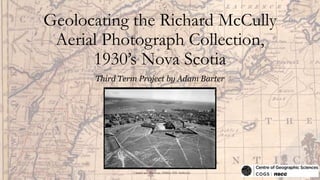
- 1. Geolocating the Richard McCully Aerial Photograph Collection, 1930’s Nova Scotia Third Term Project by Adam Barter Citadel and Harbour, Halifax (NS Archives)
- 2. The Richard McCully Aerial Photograph Collection • Photograph collection is the efforts of Richard McCully, Harold Reid (the photographer), and Marty Fraser (the pilot). • Photographs originally stored in fragile glass-plate negative format • Acquired by Nova Scotia Archives in 2012 • Digitized and stored on the Nova Scotia Archives website • Total of 221 photographs in collection • Metadata for photographs included: title of photograph, nearest city or town to photograph location, date photograph was taken, format of the photograph (glass plate negative – 12.5 cm x 17.5 cm), reference number for uniquely identifying each photograph
- 3. Examples of Damaged Glass-Plate Negatives Barker’s Limited, Amherst (NS Archives) Fort Ann and Town, Annapolis Royal (NS Archives)
- 4. Examples of Damaged Glass-Plate Negatives Nova Scotian Hotel Made Into Postcard, Halifax (NS Archives) Overview Village and Shore, Belliveau Cove (NS Archives)
- 5. Creating a File to Store Photograph Data • Original plan was to use Google Docs to store data and use the Esri article, “Using Google Docs in your ArcGIS Online maps” • However, Google Docs recently discontinued the ability to publish a spreadsheet to the web as a CSV (comma-separated values) file which was necessary for the steps in the article • Data was exported from Google Docs to Excel • Excel spreadsheet was used to store the data for the project
- 6. Data Storage Spreadsheet Design • Title, Reference Number, Location Set, Date, Photo Credits, and Image URL were all provided on the Nova Scotia Archives website. • Latitude and Longitude were generated using Google Earth • Precise / General indicates the accuracy of a latitude and longitude • Present-Day URL is a modern-day satellite image showing the same area as the 1930’s aerial photograph
- 7. Why Two Longitudes? • Allows for the ability to only map certain points while maintaining the correct coordinates for all photographs • P = Permanent / D = Delete • Examples of Use: • Map with only precise points shown • Map with only points from certain area (i.e. only Halifax points) • Map showing all photographs taken on a particular day • A Visual Basic script was created within Excel to delete the Longitude (D) values where necessary
- 8. Script for Example 1 Map with only precise points shown
- 9. Script for Example 2 Map with only points from certain area (i.e. only Halifax points)
- 10. Script for Example 3 Map showing all photographs taken on a particular day
- 11. Precise & General • Precise • Latitude / longitude coordinates are found within the photographed area • Accurate for both small-scale and large-scale • 169 / 221 photographs are classified as Precise (76%) • General • Latitude / longitude coordinates are based on the general city / town label provided by Nova Scotia Archives • Accurate for small-scale • 52 / 221 photographs are classified as General (24%)
- 12. Determining Sum and Percentage of Precise Photographs
- 13. Techniques Used To Geolocate Photographs • Use clues within the 1930’s photographs to determine where they are located (i.e. buildings, monuments, street networks, railroad tracks, rivers, lakes, coast lines, etc) • Cross-reference with photographs that have already been geolocated and share a common area • Find secondary reference material • Personal knowledge • Consult outside sources • Visit the sites
- 14. Using Clues Within the Photograph Department of Highway’s Building, Halifax (NS Archives)
- 15. Using Clues Within the Photograph Yarmouth Cotton Mills, Yarmouth (NS Archives)
- 17. Cross Referencing Overview, Kentville (NS Archives) Home by Cemetery, Kentville (NS Archives)
- 19. Secondary Reference Material Exhibition Grounds, Halifax (NS Archives) Exhibition Grounds, Halifax, 1930’s (Dunn)
- 22. Consult Outside Sources • Poor resolution satellite imagery available over Bridgetown on Google Earth • Had been to Bridgetown numerous times and did not recognize this building • Consulted Bridgetown residents Dave MacLean and Jim Verran • Notified that the street was Church Street. The central large brick building no longer stands but the building in the foreground was still standing with an unmistakeable coat of orangish-yellow paint. Large Building, Bridgetown (NS Archives)
- 23. Photograph taken by Adam Barter
- 24. Visiting Photographed Location Photograph taken by Adam BarterChurch and Home, Clarence (NS Archives)
- 25. ArcGIS Online Maps • Final Map: http://bit.ly/McCullyAerialPhotoCollection • Example 1: Map with only precise points shown • http://bit.ly/PrecisePhotographLocationsMap • Example 2: Map with only points from certain area (i.e. Halifax) • http://bit.ly/HalifaxMap • Example 3: Map showing all photographs taken on a particular day • http://bit.ly/August291931
- 26. References • Nova Scotia Archives: • http://www.novascotia.ca/nsarm/virtual/mccully/default.asp • Google Earth: • http://www.google.com/earth/ • Google Maps: • https://www.google.ca/maps/preview • Dunn, Ross – Exhibition Grounds, Halifax, 1930: • https://www.flickr.com/photos/rdb466/13543848385/