Download to read offline

![John Rocque, A Plan of ye Garden Plantation of Drumlangrig [sic] in Scotland,
the Seat of his Grace the Duke of Queensburry (1739)](https://image.slidesharecdn.com/2012locscot-130424113654-phpapp01/85/Maps-for-Local-Studies-LocScot-24-April-2013-10-320.jpg)


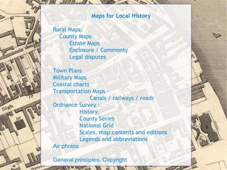
This document provides an overview and schedule for a one-day event on maps for local history studies held at the National Library of Scotland. The day includes sessions on historical maps of Scotland, cataloguing and finding aids, storage and conservation of maps, and digital mapping resources. Hands-on sessions allow attendees to view specific maps and online tools. The event aims to educate attendees on the purposes, content, and value of historical maps for local studies and the best sources for maps research.