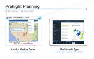
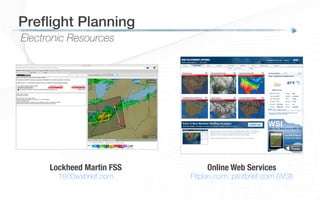
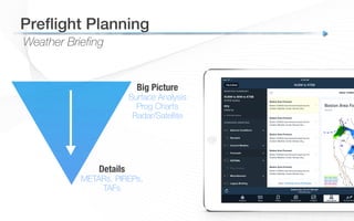
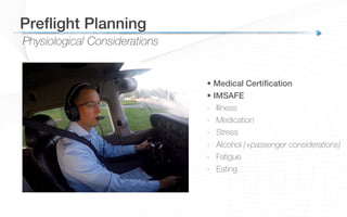
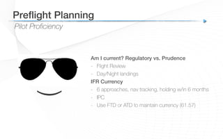
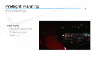
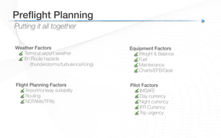
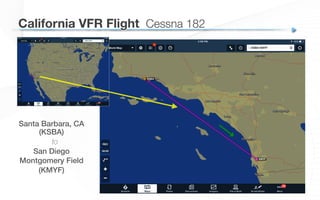
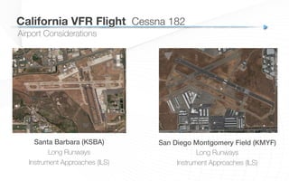
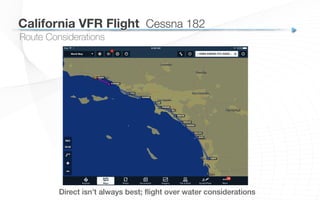
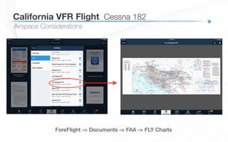
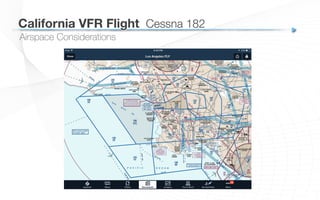
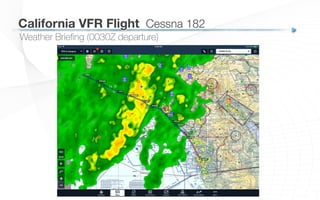
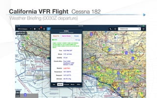
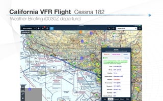
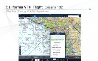
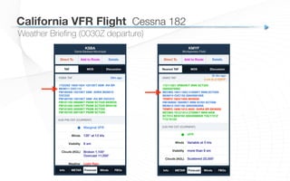
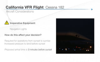
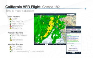
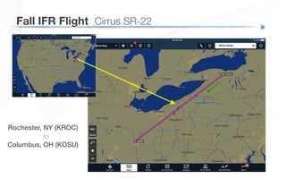
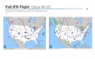
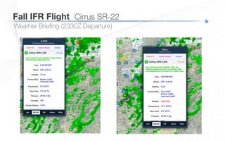
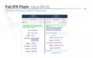
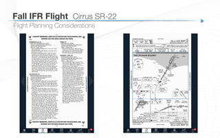
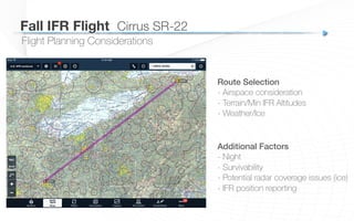
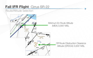
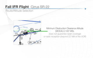
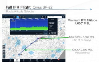
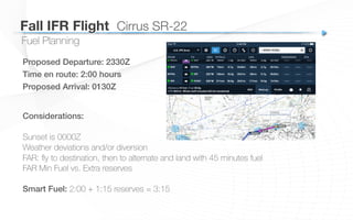
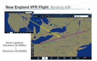
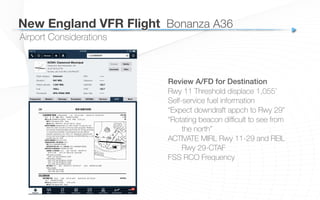
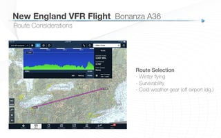
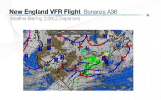
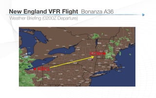
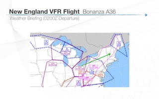
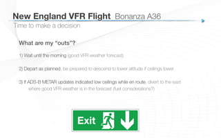
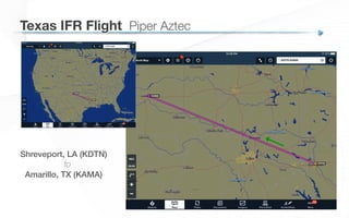
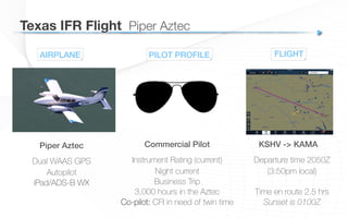
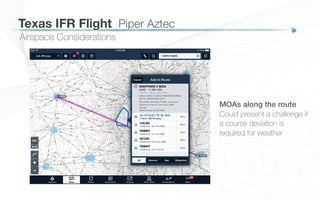
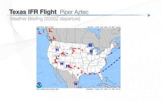
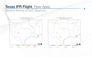
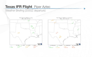
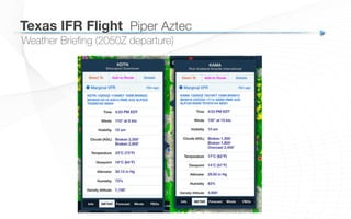
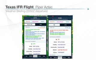
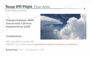
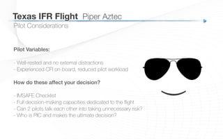
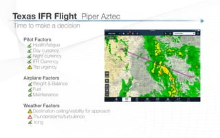
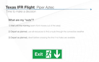
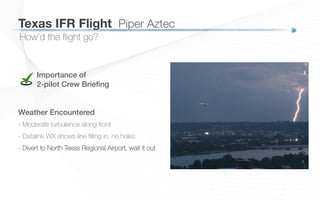
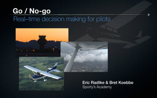
Eric Radtke & Bret Koebbe!
Go / No-go
Real–time decision making for pilots
Sporty’s Academy
Eric Radtke
• President & Chief Pilot!
Sporty’s Academy
• ATP & Master CFI!
Sporty’s Pilot Shop
!
• Editor!
Student Pilot News
Go / No-go:
 Real-time decision making for pilots
Bret Koebbe
• ATP / CFI / Vice President!
Sporty’s Academy
• App / video producer!
Sporty’s Pilot Shop
• Editor!
iPad Pilot News
Go / No-go:
 Real-time decision making for pilots
studentpilotnews.com
airfactsjournal.com
Additional resources
Sit back, relax and learn!!
- Go/No-go articles
- Real-world tips
- Free Newsletters
Preflight Planning!
Electronic Resources
Preflight Planning!
Aviation Weather Center
aviationweather.gov
iPad/Android Apps
ForeFlight, Garmin, WingX Pro
Electronic Resources
Preflight Planning!
Lockheed Martin FSS
1800wxbrief.com
Online Web Services
Fltplan.com, pilotbrief.com (WSI)
Weather Briefing
Preflight Planning!
Big Picture
Surface Analysis
Prog Charts
Radar/Satellite
Details
METARs, PIREPs,
TAFs
Weather Briefing
Preflight Planning!
• Preflight requirements!
-  91.103 – all information concerning the flight
-  Runway lengths, performance
-  IFR & away from the vicinity of the airport
-  Weather, fuel, alternatives
There is no “Official Weather Briefing”!
Weather Briefing
Preflight Planning!
Convection
Radar, Convective Outlook,
Convective Forecast, SIGMETs,
PIREPs
Turbulence
Clear Air & Mountain Wave
forecasts, AIRMETs, PIREPs
Icing
Freezing Level chart, Icing
Probability Analysis, Icing
Severity, AIRMETs, PIREPs
Weather Briefing
Preflight Planning!
IFR Alternate Requirements!
-  Filed alternate vs. what’s practical
-  Alternate airport -> GPS approach
considerations!
Facilities Briefing
Preflight Planning!
Importance of the A/FD in the age of apps
Contains critical information not found in
other resources
Facilities Briefing
Preflight Planning!
Do your research:
-  Review airport diagram
-  Satellite aerial imagery
-  Fuel options
-  Maintenance
-  Airport lighting systems & control
Call ahead to airport or!
FBO with questions!
NOTAMs – 2 Types
Preflight Planning!
D NOTAMs FDC NOTAMs
Route Consideration
Preflight Planning!
Things to consider:
-  Terrain
-  Airspace
-  TFRs
-  Traffic Flow
-  Weather
-  Aircraft capabilities
-  Contingencies
Altitude Selection
-  Direction of Flight
-  Minimum altitudes (91.119 – 500’ at all times)
-  Off-route – minimum obstruction altitudes
Aircraft Considerations
Preflight Planning!
Inoperative Equipment!
-  MEL vs. Required Equipment List
-  Is it safe and have appropriate steps been
taken for deferrals?
!
Required Inspections!
!
Oxygen Use!
-  12,500’/14,000’/15,000’
-  Best-practice – 5,000’ Night, 10,000’ Day
-  Pressurized? Need 10 min supply > FL250
Physiological Considerations
Preflight Planning!
• Medical Certification!
• IMSAFE
-  Illness
-  Medication
-  Stress
-  Alcohol (+passenger considerations)
-  Fatigue
-  Eating
Pilot Proficiency
Preflight Planning!
Am I current? Regulatory vs. Prudence!
-  Flight Review
-  Day/Night landings
IFR Currency!
-  6 approaches, nav tracking, holding w/in 6 months
-  IPC
-  Use FTD or ATD to maintain currency (61.57)
!
(
Pilot Proficiency
Preflight Planning!
Night Flying!
-  Equipment requirements
-  Cockpit organization
-  Proficiency!
Putting it all together
Preflight Planning!
Pilot Factors!
IMSAFE
Day currency
Night currency
IFR Currency
Trip urgency
Flight Planning Factors!
Airport/runway suitability
Routing
NOTAMs/TFRs
Weather Factors!
Terminal airport weather
En Route hazards
(thunderstorms/turbulence/icing)
Equipment Factors!
Weight & Balance
Fuel
Maintenance
Charts/EFB/Gear
California VFR Flight!
Scenario #1
Santa Barbara, CA
(KSBA)!
to
San Diego!
Montgomery Field!
(KMYF)
California VFR Flight
 Cessna 182
California VFR Flight
 Cessna 182
AIRPLANE
Cessna 182 Skylane
Garmin G1000
Autopilot
XM Datalink Weather
iPad/ForeFlight
PILOT PROFILE
Private Pilot
Instrument Rating (not current)
Night current (for pax carrying)
Business owner / trip
700 hours in the C182
1 passenger (business associate)
KSBA -> KMYF
Departure time 0030Z
(4:30pm local)
Time en route 1.1 hrs
Sunset is 0145Z
FLIGHT
California VFR Flight
 Cessna 182
Santa Barbara (KSBA)!
Long Runways
Instrument Approaches (ILS)
San Diego Montgomery Field (KMYF)!
Long Runways
Instrument Approaches (ILS)
!
Airport Considerations
California VFR Flight
 Cessna 182
Direct isn’t always best; flight over water considerations!
Route Considerations
California VFR Flight
 Cessna 182
Route goes through Los Angeles Class B airspace!
Airspace Considerations
California VFR Flight
 Cessna 182
ForeFlight -> Documents -> FAA -> FLY Charts!
Airspace Considerations
California VFR Flight
 Cessna 182
Airspace Considerations
California VFR Flight
 Cessna 182
Weather Briefing (0030Z departure)
California VFR Flight
 Cessna 182
Weather Briefing (0030Z departure)
California VFR Flight
 Cessna 182
Weather Briefing (0030Z departure)
California VFR Flight
 Cessna 182
Weather Briefing (0030Z departure)
California VFR Flight
 Cessna 182
Weather Briefing (0030Z departure)
California VFR Flight
 Cessna 182
Weather Briefing (0030Z departure)
California VFR Flight
 Cessna 182
Weather Briefing (0030Z departure)
Valid 0000Z! Valid 0600Z!
California VFR Flight
 Cessna 182
Weather Briefing (0030Z departure)
California VFR Flight
 Cessna 182
Proposed Departure: 0030Z!
Time en route: 1:06 hours!
Proposed Arrival: 0136Z!
Fuel Requirements
Considerations:!
Sunset is 0145Z
Weather deviations
ATC/Traffic routing/delays
FAR: land with 30 minutes DAY, 45 minutes NIGHT
FAR Min Fuel vs. Extra reserves
Smart Fuel: 1:06 + 1:00 reserves = 2:06
California VFR Flight
 Cessna 182
Pilot Considerations
Pilot Variables:!
- Recovering from a head cold
- Taking Tylenol Cold (Rule of 5)
- Work Pressures to make the trip
- Doesn’t sleep well in hotels
How do these affect your decision?!
!
- IMSAFE Checklist
- FAA-Approved Medications
California VFR Flight
 Cessna 182
Aircraft Considerations
Inoperative Equipment:!
Navigation Lights
How do this affect your decision?!
!
Required for operations from sunset to sunrise
Increased pressure to land before sunset
Proposed arrival time is 9 minutes before sunset
California VFR Flight
 Cessna 182
Time to make a decision
Pilot Factors!
Health
Day currency
Night currency
IFR Currency
Trip urgency
Airplane Factors!
Weight & Balance
Fuel
Maintenance
Weather Factors!
VFR Ceiling
VFR Visibility
Thunderstorms/icing/turbulence/winds
California VFR Flight
 Cessna 182
Time to make a decision
What are my “outs”?
1) Wait until the morning (good VFR weather forecast)
2) Depart as planned, be prepared to land at an alternate if weather deteriorates
3) If you get “caught” in IFR weather, you have the skills to fly an approach to get
safely on the ground (though this wouldn’t be legal)
4) If delays push you towards a sunset landing, diversion possible (inop nav lights)!
California VFR Flight
 Cessna 182
How’d the flight go?
Importance of!
Passenger Briefing!
!
Weather Variables!
- Ceilings and visibility good for departure
- Visibility as low as 3 SM and 1,400’ ceilings,
moderate rain showers
- Thunderstorms/turbulence/icing not a factor
- VFR over the top is an option (not VFR ON TOP)
Passenger needs to make phone call en route!
Is this legal?!
Fall IFR Flight!
Scenario #2
Rochester, NY (KROC)!
to
Columbus, OH (KOSU)
Fall IFR Flight
 Cirrus SR-22
AIRPLANE
Cirrus SR-22
Avidyne GPS/Moving-Map
Autopilot
iPad/ForeFlight
PILOT PROFILE
Private Pilot
Instrument Rating
Night current
Business trip
200 hours in the SR-22
600 hours total (70 in last 6 months)
KROC -> KOSU
Departure time 2330Z
(6:30pm local)
Time en route 2.0 hrs
Sunset is 0000Z
FLIGHT
Fall IFR Flight
 Cirrus SR-22
Rochester (KROC)!
Long Runways
Instrument Approaches (ILS)
ATC Control Tower
Columbus, OH (KOSU)!
Long Runways
Instrument Approaches (ILS)
ATC Control Tower
!
Airport Considerations
Fall IFR Flight
 Cirrus SR-22
Weather Briefing (2330Z Departure)
Fall IFR Flight
 Cirrus SR-22
Weather Briefing (2330Z Departure)
Fall IFR Flight
 Cirrus SR-22
Weather Briefing (2330Z Departure)
Fall IFR Flight
 Cirrus SR-22
Weather Briefing (2330Z Departure)
Fall IFR Flight
 Cirrus SR-22
Weather Briefing (2330Z Departure)
Fall IFR Flight
 Cirrus SR-22
Weather Briefing (2330Z Departure)
Fall IFR Flight
 Cirrus SR-22
Weather Briefing (2330Z Departure)
Fall IFR Flight
 Cirrus SR-22
Weather Briefing (2330Z Departure)
Fall IFR Flight
 Cirrus SR-22
Weather Briefing (2330Z Departure)
Fall IFR Flight
 Cirrus SR-22
Weather Briefing (2330Z Departure)
Fall IFR Flight
 Cirrus SR-22
Weather Briefing (2330Z Departure)
Fall IFR Flight
 Cirrus SR-22
Flight Planning Considerations
Fall IFR Flight
 Cirrus SR-22
Route Selection!
- Airspace consideration
- Terrain/Min IFR Altitudes
- Weather/Ice
!
Flight Planning Considerations
Additional Factors!
- Night
- Survivability
- Potential radar coverage issues (ice)
- IFR position reporting
!
Fall IFR Flight
 Cirrus SR-22
Route/Altitude Selection
Minimum En Route Altitude
(MEA) 3,000’ MSL
Off Route Obstruction Clearance
Altitude (OROCA) 3,500’ MSL
Fall IFR Flight
 Cirrus SR-22
Route/Altitude Selection
Minimum Obstruction Clearance Altitude
(MOCA) 2,100’ MSL
does not guarantee radar coverage
or radio reception (beyond 22 NM of the VOR)
Fall IFR Flight
 Cirrus SR-22
Route/Altitude Selection
MEA 2,800 – 3,000’ MSL
Start off on airways
OROCA 3,500’ MSL
Proceed direct
Minimum IFR Altitude!
4,000’ MSL!
Fall IFR Flight
 Cirrus SR-22
Fuel Planning
IFR Night Flight!
Alternate Required?!
- P6SM & Clouds Broken 2,400’
- Alternate required: 1 hour before
to 1 hour after ETA, Ceiling < 2,000’
and Visibility < 3 SM
Fall IFR Flight
 Cirrus SR-22
Fuel Planning
Proposed Departure: 2330Z!
Time en route: 2:00 hours!
Proposed Arrival: 0130Z!
Considerations:!
Sunset is 0000Z
Weather deviations and/or diversion
FAR: fly to destination, then to alternate and land with 45 minutes fuel
FAR Min Fuel vs. Extra reserves
Smart Fuel: 2:00 + 1:15 reserves = 3:15
Fall IFR Flight
 Cirrus SR-22
Pilot Considerations
Pilot Variables:!
- Up early in the morning
- Long day of meetings
- Critical business decisions
- Commitments early next morning
How do these affect your decision?!
!
- IMSAFE Checklist
- Fatigue affects night vision & decision making
––
Fall IFR Flight
 Cirrus SR-22
Time to make a decision
Pilot Factors!
Health/fatigue
Day currency
Night currency
IFR Currency
Trip urgency
Airplane Factors!
Weight & Balance
Fuel
Maintenance
Weather Factors!
Destination ceiling/visibility for approach
Thunderstorms/turbulence
Icing!
Fall IFR Flight
 Cirrus SR-22
Time to make a decision
What are my “outs”?
Wait until the morning (Cold front and low pressure move out of area)
Depart as planned, be prepared fly at MEA if ice becomes a factor at higher altitudes
If weather gets convective or you pick up in-flight ice, request routing to the south
!
!
Fall IFR Flight
 Cirrus SR-22
How’d the flight go?
Weather Variables
- Moderate turbulence (unforecast)
- ATC Emergency (ice)
ATC/Navigation Variables
- Out of radar contact when amended
routing becomes necessary
- Loss of Comm at low altitudes
- ATC Emergency (weather)
Fall IFR Flight
 Cirrus SR-22
New England VFR Flight!
Scenario #3
Burke Lakefront!
Cleveland, OH (KBKL)!
to
Claremont, NH (KCNH)
New England VFR Flight
 Bonanza A36
New England VFR Flight
 Bonanza A36
PILOT PROFILE
Private Pilot!
No Instrument Rating
Night current (for pax carrying)
Family Trip
500 hours in the A36
3 passengers (family)
AIRPLANE
Bonanza A36!
GPS-equipped
Autopilot
ADS-B In Weather (iPad)
KBKL-> KCNH!
Departure time 0200Z
(9:00pm local)
Time en route 2.5 hrs
Sunset is 2300Z
FLIGHT
Burke Lakefront (KBKL)!
Long Runway
Instrument Approaches (ILS)
ATC Tower
Claremont Municipal (KCNH)!
3,100’ Runway
Non-precision instrument approach
Non-towered
!
Airport Considerations
New England VFR Flight
 Bonanza A36
Review A/FD for Destination!
Rwy 11 Threshold displace 1,055’
Self-service fuel information
“Expect downdraft appch to Rwy 29”
“Rotating beacon difficult to see from
the north”
ACTIVATE MIRL Rwy 11-29 and REIL
Rwy 29-CTAF
FSS RCO Frequency
Airport Considerations
New England VFR Flight
 Bonanza A36
NOTAMS for Departure Airport!
Upcoming Race on the runways
Runway 6R/24L CLOSED
Runway 24R reduced to 2,500’
usable
How does this affect performance
planning and W&B?
Airport Considerations
New England VFR Flight
 Bonanza A36
Route Considerations
New England VFR Flight
 Bonanza A36
Route Selection!
- Winter flying
- Survivability
- Cold weather gear (off-airport ldg.)
Weather Briefing (0200Z Departure)
New England VFR Flight
 Bonanza A36
Weather Briefing (0200Z Departure)
New England VFR Flight
 Bonanza A36
Weather Briefing (0200Z Departure)
New England VFR Flight
 Bonanza A36
Weather Briefing (0200Z Departure)
New England VFR Flight
 Bonanza A36
Weather Briefing (0200Z Departure)
New England VFR Flight
 Bonanza A36
KBKL 152353Z 16006KT 10SM OVC100 06/M02 A3018
RMK AO2 SLP224 T00561017 10072 20050 53002
KBKL 160053Z 14005KT 10SM SCT095 05/M02 A3017
RMK AO2 SLP220 T00501017
KBKL 160153Z 15010G16KT 10SM OVC085 05/M01 A3015
RMK AO2 SLP215 T00501011
Departure METAR
Weather Briefing (0200Z Departure)
New England VFR Flight
 Bonanza A36
KCLE 152339Z 1600/1706 17006KT P6SM SCT050 OVC080
TEMPO 1602/1605 4SM -RA SCT025 OVC035
FM160500 16008KT 5SM -RA BR SCT025 OVC035
FM160900 16008KT 4SM -RA BR SCT015 OVC025
TEMPO 1612/1616 1 1/2SM -RA BR SCT006 OVC012
FM161800 25010KT P6SM OVC025
FM162100 26010KT P6SM OVC035
Departure TAF
Weather Briefing (0200Z Departure)
New England VFR Flight
 Bonanza A36
KBUF 160254Z 13006KT 10SM FEW100 SCT250 M01/M04 A3020
RMK AO2 SLP237 T10111044 55009
KALB 160251Z 27005KT 10SM OVC036 02/M02 A3029
RMK AO2 SLP259 T00221017 51008
En Route METARs
Weather Briefing (0200Z Departure)
New England VFR Flight
 Bonanza A36
KLEB 160153Z 00000KT 10SM BKN027 OVC038 02/M02 A3021
RMK AO2 SLP239 T00171022
KVSF 160154Z AUTO 28003KT 10SM FEW026 SCT034 OVC041
03/M02 A3023 RMK AO2 SLP243 T00331017
METARs near destination
Weather Briefing (0200Z Departure)
New England VFR Flight
 Bonanza A36
KALB 152326Z 1600/1624 00000KT P6SM FEW040 FEW090
     FM160600 00000KT P6SM SCT110 SCT250
     FM161200 VRB03KT P6SM BKN110 OVC200
     FM161800 17004KT 4SM -RA BR SCT020 BKN035 OVC070
Closest TAF (70 NM southwest)
Fuel Requirements
New England VFR Flight
 Bonanza A36
Proposed Departure: 0200Z!
Time en route: 2:30 hours!
Proposed Arrival: 0430Z!
Considerations:!
Sunset is 2300Z
FAR: land with 30 minutes DAY, 45 minutes NIGHT
FAR Min Fuel vs. Extra reserves (may need to travel further East if ceilings drop)
Smart Fuel: 2:30 + 1:15 reserves = 3:45
Pilot Considerations
New England VFR Flight
 Bonanza A36
Pilot Variables:!
- Family pressures to get to vacation
- Several drinks the night before
- Former smoker
- Commitments early next morning
How do these affect your decision?!
!
- IMSAFE Checklist
- External habits affects night vision & decision making
––
Aircraft Considerations
New England VFR Flight
 Bonanza A36
Intermittent Oil Pressure Warning Light!
Forgot to charge iPad (primary charts)!
No backup & no charging source
Navigation Lights!
Operating Requirements
Time to make a decision
New England VFR Flight
 Bonanza A36
Pilot Factors!
Health/fatigue
Day currency
Night currency
IFR Currency
Trip urgency
Airplane Factors!
Performance
Weight & Balance
Fuel
Maintenance
Weather Factors!
Departure Clouds/Ceiling
Arrival Clouds/Ceiling
WX Hazards (thunderstorms/turbulence/icing)!
Time to make a decision
New England VFR Flight
 Bonanza A36
What are my “outs”?
1) Wait until the morning (good VFR weather forecast)
2) Depart as planned, be prepared to descend to lower altitude if ceilings lower
3) If ADS-B METAR updates indicated low ceilings while en route, divert to the east
where good VFR weather is in the forecast (fuel considerations?)
How’d the flight go?
New England VFR Flight
 Bonanza A36
Weather Encountered
- Mist in Cleveland at departure reduces visibility
for Takeoff to 2 miles – Special VFR?
- Keep up with METAR reports near destination
with ADS-B datalink weather on the iPad
- Inadvertent flight into IMC nearing destination
Importance of!
Passenger Briefing!
How’d the flight go?
New England VFR Flight
 Bonanza A36
En Route Decision Making
- Oxygen use at 9,500’ (Night flight)
- Disposable BOOST canisters
- Oil Pressure warning on descent to destination
- Checklist? Procedure?
-  Runway light activation for landing
-  Landing light inop
-  Black hole effect during landing
-  Displaced threshold Rwy 11
Texas IFR Flight!
Scenario #4
Shreveport, LA (KDTN)!
to
Amarillo, TX (KAMA)
Texas IFR Flight
 Piper Aztec
PILOT PROFILE
Commercial Pilot!
Instrument Rating (current)
Night current
Business Trip
3,000 hours in the Aztec
Co-pilot: CFI in need of twin time
AIRPLANE
Piper Aztec!
Dual WAAS GPS
Autopilot
iPad/ADS-B WX
Texas IFR Flight
 Piper Aztec
KSHV -> KAMA!
Departure time 2050Z
(3:50pm local)
Time en route 2.5 hrs
Sunset is 0100Z
FLIGHT
Shreveport (KDTN)!
Long Runways
Instrument Approaches (ILS)
ATC Control Tower
Amarillo (KAMA)
Long Runways
Instrument Approaches (ILS)
ATC Control Tower
Airport Considerations
Texas IFR Flight
 Piper Aztec
MOAs along the route!
Could present a challenge if
a course deviation is
required for weather
Airspace Considerations
Texas IFR Flight
 Piper Aztec
Weather Briefing (2050Z departure)
Texas IFR Flight
 Piper Aztec
Weather Briefing (2050Z departure)
Texas IFR Flight
 Piper Aztec
Weather Briefing (2050Z departure)
Texas IFR Flight
 Piper Aztec
Convective Forecast
Planning!
Convective Outlook!
These are examples of forecasts (not to be used for the Texas IFR scenario)
Weather Briefing (2050Z departure)
Texas IFR Flight
 Piper Aztec
Weather Briefing (2050Z departure)
Texas IFR Flight
 Piper Aztec
Weather Briefing (2050Z departure)
Texas IFR Flight
 Piper Aztec
Weather Briefing (2050Z departure)
Texas IFR Flight
 Piper Aztec
Weather Briefing (2050Z departure)
Texas IFR Flight
 Piper Aztec
Weather Briefing (2050Z departure)
Texas IFR Flight
 Piper Aztec
Weather Briefing (2050Z departure)
Texas IFR Flight
 Piper Aztec
Fuel Requirements
Texas IFR Flight
 Piper Aztec
Proposed Departure: 2050Z!
Time en route: 2:30 hours!
Proposed Arrival: 2320Z!
Considerations:!
FAR: land with 30 minutes DAY
FAR Min Fuel vs. Extra reserves (potential thunderstorm deviations or diversion)
Smart Fuel: 2:30 + 1:00 reserves = 3:30
Pilot Considerations
Texas IFR Flight
 Piper Aztec
Pilot Variables:!
- Well-rested and no external distractions
- Experienced CFI on-board, reduced pilot workload
How do these affect your decision?!
!
- IMSAFE Checklist
- Full decision-making capacities dedicated to the flight
- Can 2 pilots talk each other into taking unnecessary risk?
- Who is PIC and makes the ultimate decision?
(
Aircraft Considerations
Texas IFR Flight
 Piper Aztec
ADS-B Datalink Weather!
5 – 10 minute delay, no close WX flying
!
De-ice boots placarded inoperative
Time to make a decision
Texas IFR Flight
 Piper Aztec
Pilot Factors!
Health/fatigue
Day currency
Night currency
IFR Currency
Trip urgency
Airplane Factors!
Weight & Balance
Fuel
Maintenance
Weather Factors!
Destination ceiling/visibility for approach
Thunderstorms/turbulence
Icing!
Time to make a decision
Texas IFR Flight
 Piper Aztec
What are my “outs”?
1) Wait until the morning (warm front moves out of the area)
2) Depart as planned, use all resources to find a route through the convective weather
3) Depart as planned, divert before crossing the line if no holes are available
How’d the flight go?
Texas IFR Flight
 Piper Aztec
Weather Encountered
- Moderate turbulence along front
- Datalink WX shows line filling in, no holes
- Divert to North Texas Regional Airport, wait it out
Importance of!
2-pilot Crew Briefing!
Eric Radtke & Bret Koebbe!
Go / No-go
Real–time decision making for pilots
Sporty’s Academy

The Go/No-Go Decision: Real-time decision making for pilots

  • 1.
    Eric Radtke &Bret Koebbe! Go / No-go Real–time decision making for pilots Sporty’s Academy
  • 2.
    Eric Radtke • President& Chief Pilot! Sporty’s Academy • ATP & Master CFI! Sporty’s Pilot Shop ! • Editor! Student Pilot News Go / No-go: Real-time decision making for pilots
  • 3.
    Bret Koebbe • ATP/ CFI / Vice President! Sporty’s Academy • App / video producer! Sporty’s Pilot Shop • Editor! iPad Pilot News Go / No-go: Real-time decision making for pilots
  • 4.
    studentpilotnews.com airfactsjournal.com Additional resources Sit back,relax and learn!! - Go/No-go articles - Real-world tips - Free Newsletters
  • 5.
  • 6.
    Electronic Resources Preflight Planning! AviationWeather Center aviationweather.gov iPad/Android Apps ForeFlight, Garmin, WingX Pro
  • 7.
    Electronic Resources Preflight Planning! LockheedMartin FSS 1800wxbrief.com Online Web Services Fltplan.com, pilotbrief.com (WSI)
  • 8.
    Weather Briefing Preflight Planning! BigPicture Surface Analysis Prog Charts Radar/Satellite Details METARs, PIREPs, TAFs
  • 9.
    Weather Briefing Preflight Planning! •Preflight requirements! -  91.103 – all information concerning the flight -  Runway lengths, performance -  IFR & away from the vicinity of the airport -  Weather, fuel, alternatives There is no “Official Weather Briefing”!
  • 10.
    Weather Briefing Preflight Planning! Convection Radar,Convective Outlook, Convective Forecast, SIGMETs, PIREPs Turbulence Clear Air & Mountain Wave forecasts, AIRMETs, PIREPs Icing Freezing Level chart, Icing Probability Analysis, Icing Severity, AIRMETs, PIREPs
  • 11.
    Weather Briefing Preflight Planning! IFRAlternate Requirements! -  Filed alternate vs. what’s practical -  Alternate airport -> GPS approach considerations!
  • 12.
    Facilities Briefing Preflight Planning! Importanceof the A/FD in the age of apps Contains critical information not found in other resources
  • 13.
    Facilities Briefing Preflight Planning! Doyour research: -  Review airport diagram -  Satellite aerial imagery -  Fuel options -  Maintenance -  Airport lighting systems & control Call ahead to airport or! FBO with questions!
  • 14.
    NOTAMs – 2Types Preflight Planning! D NOTAMs FDC NOTAMs
  • 15.
    Route Consideration Preflight Planning! Thingsto consider: -  Terrain -  Airspace -  TFRs -  Traffic Flow -  Weather -  Aircraft capabilities -  Contingencies Altitude Selection -  Direction of Flight -  Minimum altitudes (91.119 – 500’ at all times) -  Off-route – minimum obstruction altitudes
  • 16.
    Aircraft Considerations Preflight Planning! InoperativeEquipment! -  MEL vs. Required Equipment List -  Is it safe and have appropriate steps been taken for deferrals? ! Required Inspections! ! Oxygen Use! -  12,500’/14,000’/15,000’ -  Best-practice – 5,000’ Night, 10,000’ Day -  Pressurized? Need 10 min supply > FL250
  • 17.
    Physiological Considerations Preflight Planning! •Medical Certification! • IMSAFE -  Illness -  Medication -  Stress -  Alcohol (+passenger considerations) -  Fatigue -  Eating
  • 18.
    Pilot Proficiency Preflight Planning! AmI current? Regulatory vs. Prudence! -  Flight Review -  Day/Night landings IFR Currency! -  6 approaches, nav tracking, holding w/in 6 months -  IPC -  Use FTD or ATD to maintain currency (61.57) ! (
  • 19.
    Pilot Proficiency Preflight Planning! NightFlying! -  Equipment requirements -  Cockpit organization -  Proficiency!
  • 20.
    Putting it alltogether Preflight Planning! Pilot Factors! IMSAFE Day currency Night currency IFR Currency Trip urgency Flight Planning Factors! Airport/runway suitability Routing NOTAMs/TFRs Weather Factors! Terminal airport weather En Route hazards (thunderstorms/turbulence/icing) Equipment Factors! Weight & Balance Fuel Maintenance Charts/EFB/Gear
  • 21.
  • 22.
    Santa Barbara, CA (KSBA)! to SanDiego! Montgomery Field! (KMYF) California VFR Flight Cessna 182
  • 23.
    California VFR Flight Cessna 182 AIRPLANE Cessna 182 Skylane Garmin G1000 Autopilot XM Datalink Weather iPad/ForeFlight PILOT PROFILE Private Pilot Instrument Rating (not current) Night current (for pax carrying) Business owner / trip 700 hours in the C182 1 passenger (business associate) KSBA -> KMYF Departure time 0030Z (4:30pm local) Time en route 1.1 hrs Sunset is 0145Z FLIGHT
  • 24.
    California VFR Flight Cessna 182 Santa Barbara (KSBA)! Long Runways Instrument Approaches (ILS) San Diego Montgomery Field (KMYF)! Long Runways Instrument Approaches (ILS) ! Airport Considerations
  • 25.
    California VFR Flight Cessna 182 Direct isn’t always best; flight over water considerations! Route Considerations
  • 26.
    California VFR Flight Cessna 182 Route goes through Los Angeles Class B airspace! Airspace Considerations
  • 27.
    California VFR Flight Cessna 182 ForeFlight -> Documents -> FAA -> FLY Charts! Airspace Considerations
  • 28.
    California VFR Flight Cessna 182 Airspace Considerations
  • 29.
    California VFR Flight Cessna 182 Weather Briefing (0030Z departure)
  • 30.
    California VFR Flight Cessna 182 Weather Briefing (0030Z departure)
  • 31.
    California VFR Flight Cessna 182 Weather Briefing (0030Z departure)
  • 32.
    California VFR Flight Cessna 182 Weather Briefing (0030Z departure)
  • 33.
    California VFR Flight Cessna 182 Weather Briefing (0030Z departure)
  • 34.
    California VFR Flight Cessna 182 Weather Briefing (0030Z departure)
  • 35.
    California VFR Flight Cessna 182 Weather Briefing (0030Z departure) Valid 0000Z! Valid 0600Z!
  • 36.
    California VFR Flight Cessna 182 Weather Briefing (0030Z departure)
  • 37.
    California VFR Flight Cessna 182 Proposed Departure: 0030Z! Time en route: 1:06 hours! Proposed Arrival: 0136Z! Fuel Requirements Considerations:! Sunset is 0145Z Weather deviations ATC/Traffic routing/delays FAR: land with 30 minutes DAY, 45 minutes NIGHT FAR Min Fuel vs. Extra reserves Smart Fuel: 1:06 + 1:00 reserves = 2:06
  • 38.
    California VFR Flight Cessna 182 Pilot Considerations Pilot Variables:! - Recovering from a head cold - Taking Tylenol Cold (Rule of 5) - Work Pressures to make the trip - Doesn’t sleep well in hotels How do these affect your decision?! ! - IMSAFE Checklist - FAA-Approved Medications
  • 39.
    California VFR Flight Cessna 182 Aircraft Considerations Inoperative Equipment:! Navigation Lights How do this affect your decision?! ! Required for operations from sunset to sunrise Increased pressure to land before sunset Proposed arrival time is 9 minutes before sunset
  • 40.
    California VFR Flight Cessna 182 Time to make a decision Pilot Factors! Health Day currency Night currency IFR Currency Trip urgency Airplane Factors! Weight & Balance Fuel Maintenance Weather Factors! VFR Ceiling VFR Visibility Thunderstorms/icing/turbulence/winds
  • 41.
    California VFR Flight Cessna 182 Time to make a decision What are my “outs”? 1) Wait until the morning (good VFR weather forecast) 2) Depart as planned, be prepared to land at an alternate if weather deteriorates 3) If you get “caught” in IFR weather, you have the skills to fly an approach to get safely on the ground (though this wouldn’t be legal) 4) If delays push you towards a sunset landing, diversion possible (inop nav lights)!
  • 42.
    California VFR Flight Cessna 182 How’d the flight go? Importance of! Passenger Briefing! ! Weather Variables! - Ceilings and visibility good for departure - Visibility as low as 3 SM and 1,400’ ceilings, moderate rain showers - Thunderstorms/turbulence/icing not a factor - VFR over the top is an option (not VFR ON TOP) Passenger needs to make phone call en route! Is this legal?!
  • 43.
  • 44.
    Rochester, NY (KROC)! to Columbus,OH (KOSU) Fall IFR Flight Cirrus SR-22
  • 45.
    AIRPLANE Cirrus SR-22 Avidyne GPS/Moving-Map Autopilot iPad/ForeFlight PILOTPROFILE Private Pilot Instrument Rating Night current Business trip 200 hours in the SR-22 600 hours total (70 in last 6 months) KROC -> KOSU Departure time 2330Z (6:30pm local) Time en route 2.0 hrs Sunset is 0000Z FLIGHT Fall IFR Flight Cirrus SR-22
  • 46.
    Rochester (KROC)! Long Runways InstrumentApproaches (ILS) ATC Control Tower Columbus, OH (KOSU)! Long Runways Instrument Approaches (ILS) ATC Control Tower ! Airport Considerations Fall IFR Flight Cirrus SR-22
  • 47.
    Weather Briefing (2330ZDeparture) Fall IFR Flight Cirrus SR-22
  • 48.
    Weather Briefing (2330ZDeparture) Fall IFR Flight Cirrus SR-22
  • 49.
    Weather Briefing (2330ZDeparture) Fall IFR Flight Cirrus SR-22
  • 50.
    Weather Briefing (2330ZDeparture) Fall IFR Flight Cirrus SR-22
  • 51.
    Weather Briefing (2330ZDeparture) Fall IFR Flight Cirrus SR-22
  • 52.
    Weather Briefing (2330ZDeparture) Fall IFR Flight Cirrus SR-22
  • 53.
    Weather Briefing (2330ZDeparture) Fall IFR Flight Cirrus SR-22
  • 54.
    Weather Briefing (2330ZDeparture) Fall IFR Flight Cirrus SR-22
  • 55.
    Weather Briefing (2330ZDeparture) Fall IFR Flight Cirrus SR-22
  • 56.
    Weather Briefing (2330ZDeparture) Fall IFR Flight Cirrus SR-22
  • 57.
    Weather Briefing (2330ZDeparture) Fall IFR Flight Cirrus SR-22
  • 58.
    Flight Planning Considerations FallIFR Flight Cirrus SR-22
  • 59.
    Route Selection! - Airspaceconsideration - Terrain/Min IFR Altitudes - Weather/Ice ! Flight Planning Considerations Additional Factors! - Night - Survivability - Potential radar coverage issues (ice) - IFR position reporting ! Fall IFR Flight Cirrus SR-22
  • 60.
    Route/Altitude Selection Minimum EnRoute Altitude (MEA) 3,000’ MSL Off Route Obstruction Clearance Altitude (OROCA) 3,500’ MSL Fall IFR Flight Cirrus SR-22
  • 61.
    Route/Altitude Selection Minimum ObstructionClearance Altitude (MOCA) 2,100’ MSL does not guarantee radar coverage or radio reception (beyond 22 NM of the VOR) Fall IFR Flight Cirrus SR-22
  • 62.
    Route/Altitude Selection MEA 2,800– 3,000’ MSL Start off on airways OROCA 3,500’ MSL Proceed direct Minimum IFR Altitude! 4,000’ MSL! Fall IFR Flight Cirrus SR-22
  • 63.
    Fuel Planning IFR NightFlight! Alternate Required?! - P6SM & Clouds Broken 2,400’ - Alternate required: 1 hour before to 1 hour after ETA, Ceiling < 2,000’ and Visibility < 3 SM Fall IFR Flight Cirrus SR-22
  • 64.
    Fuel Planning Proposed Departure:2330Z! Time en route: 2:00 hours! Proposed Arrival: 0130Z! Considerations:! Sunset is 0000Z Weather deviations and/or diversion FAR: fly to destination, then to alternate and land with 45 minutes fuel FAR Min Fuel vs. Extra reserves Smart Fuel: 2:00 + 1:15 reserves = 3:15 Fall IFR Flight Cirrus SR-22
  • 65.
    Pilot Considerations Pilot Variables:! -Up early in the morning - Long day of meetings - Critical business decisions - Commitments early next morning How do these affect your decision?! ! - IMSAFE Checklist - Fatigue affects night vision & decision making –– Fall IFR Flight Cirrus SR-22
  • 66.
    Time to makea decision Pilot Factors! Health/fatigue Day currency Night currency IFR Currency Trip urgency Airplane Factors! Weight & Balance Fuel Maintenance Weather Factors! Destination ceiling/visibility for approach Thunderstorms/turbulence Icing! Fall IFR Flight Cirrus SR-22
  • 67.
    Time to makea decision What are my “outs”? Wait until the morning (Cold front and low pressure move out of area) Depart as planned, be prepared fly at MEA if ice becomes a factor at higher altitudes If weather gets convective or you pick up in-flight ice, request routing to the south ! ! Fall IFR Flight Cirrus SR-22
  • 68.
    How’d the flightgo? Weather Variables - Moderate turbulence (unforecast) - ATC Emergency (ice) ATC/Navigation Variables - Out of radar contact when amended routing becomes necessary - Loss of Comm at low altitudes - ATC Emergency (weather) Fall IFR Flight Cirrus SR-22
  • 69.
    New England VFRFlight! Scenario #3
  • 70.
    Burke Lakefront! Cleveland, OH(KBKL)! to Claremont, NH (KCNH) New England VFR Flight Bonanza A36
  • 71.
    New England VFRFlight Bonanza A36 PILOT PROFILE Private Pilot! No Instrument Rating Night current (for pax carrying) Family Trip 500 hours in the A36 3 passengers (family) AIRPLANE Bonanza A36! GPS-equipped Autopilot ADS-B In Weather (iPad) KBKL-> KCNH! Departure time 0200Z (9:00pm local) Time en route 2.5 hrs Sunset is 2300Z FLIGHT
  • 72.
    Burke Lakefront (KBKL)! LongRunway Instrument Approaches (ILS) ATC Tower Claremont Municipal (KCNH)! 3,100’ Runway Non-precision instrument approach Non-towered ! Airport Considerations New England VFR Flight Bonanza A36
  • 73.
    Review A/FD forDestination! Rwy 11 Threshold displace 1,055’ Self-service fuel information “Expect downdraft appch to Rwy 29” “Rotating beacon difficult to see from the north” ACTIVATE MIRL Rwy 11-29 and REIL Rwy 29-CTAF FSS RCO Frequency Airport Considerations New England VFR Flight Bonanza A36
  • 74.
    NOTAMS for DepartureAirport! Upcoming Race on the runways Runway 6R/24L CLOSED Runway 24R reduced to 2,500’ usable How does this affect performance planning and W&B? Airport Considerations New England VFR Flight Bonanza A36
  • 75.
    Route Considerations New EnglandVFR Flight Bonanza A36 Route Selection! - Winter flying - Survivability - Cold weather gear (off-airport ldg.)
  • 76.
    Weather Briefing (0200ZDeparture) New England VFR Flight Bonanza A36
  • 77.
    Weather Briefing (0200ZDeparture) New England VFR Flight Bonanza A36
  • 78.
    Weather Briefing (0200ZDeparture) New England VFR Flight Bonanza A36
  • 79.
    Weather Briefing (0200ZDeparture) New England VFR Flight Bonanza A36
  • 80.
    Weather Briefing (0200ZDeparture) New England VFR Flight Bonanza A36 KBKL 152353Z 16006KT 10SM OVC100 06/M02 A3018 RMK AO2 SLP224 T00561017 10072 20050 53002 KBKL 160053Z 14005KT 10SM SCT095 05/M02 A3017 RMK AO2 SLP220 T00501017 KBKL 160153Z 15010G16KT 10SM OVC085 05/M01 A3015 RMK AO2 SLP215 T00501011 Departure METAR
  • 81.
    Weather Briefing (0200ZDeparture) New England VFR Flight Bonanza A36 KCLE 152339Z 1600/1706 17006KT P6SM SCT050 OVC080 TEMPO 1602/1605 4SM -RA SCT025 OVC035 FM160500 16008KT 5SM -RA BR SCT025 OVC035 FM160900 16008KT 4SM -RA BR SCT015 OVC025 TEMPO 1612/1616 1 1/2SM -RA BR SCT006 OVC012 FM161800 25010KT P6SM OVC025 FM162100 26010KT P6SM OVC035 Departure TAF
  • 82.
    Weather Briefing (0200ZDeparture) New England VFR Flight Bonanza A36 KBUF 160254Z 13006KT 10SM FEW100 SCT250 M01/M04 A3020 RMK AO2 SLP237 T10111044 55009 KALB 160251Z 27005KT 10SM OVC036 02/M02 A3029 RMK AO2 SLP259 T00221017 51008 En Route METARs
  • 83.
    Weather Briefing (0200ZDeparture) New England VFR Flight Bonanza A36 KLEB 160153Z 00000KT 10SM BKN027 OVC038 02/M02 A3021 RMK AO2 SLP239 T00171022 KVSF 160154Z AUTO 28003KT 10SM FEW026 SCT034 OVC041 03/M02 A3023 RMK AO2 SLP243 T00331017 METARs near destination
  • 84.
    Weather Briefing (0200ZDeparture) New England VFR Flight Bonanza A36 KALB 152326Z 1600/1624 00000KT P6SM FEW040 FEW090      FM160600 00000KT P6SM SCT110 SCT250      FM161200 VRB03KT P6SM BKN110 OVC200      FM161800 17004KT 4SM -RA BR SCT020 BKN035 OVC070 Closest TAF (70 NM southwest)
  • 85.
    Fuel Requirements New EnglandVFR Flight Bonanza A36 Proposed Departure: 0200Z! Time en route: 2:30 hours! Proposed Arrival: 0430Z! Considerations:! Sunset is 2300Z FAR: land with 30 minutes DAY, 45 minutes NIGHT FAR Min Fuel vs. Extra reserves (may need to travel further East if ceilings drop) Smart Fuel: 2:30 + 1:15 reserves = 3:45
  • 86.
    Pilot Considerations New EnglandVFR Flight Bonanza A36 Pilot Variables:! - Family pressures to get to vacation - Several drinks the night before - Former smoker - Commitments early next morning How do these affect your decision?! ! - IMSAFE Checklist - External habits affects night vision & decision making ––
  • 87.
    Aircraft Considerations New EnglandVFR Flight Bonanza A36 Intermittent Oil Pressure Warning Light! Forgot to charge iPad (primary charts)! No backup & no charging source Navigation Lights! Operating Requirements
  • 88.
    Time to makea decision New England VFR Flight Bonanza A36 Pilot Factors! Health/fatigue Day currency Night currency IFR Currency Trip urgency Airplane Factors! Performance Weight & Balance Fuel Maintenance Weather Factors! Departure Clouds/Ceiling Arrival Clouds/Ceiling WX Hazards (thunderstorms/turbulence/icing)!
  • 89.
    Time to makea decision New England VFR Flight Bonanza A36 What are my “outs”? 1) Wait until the morning (good VFR weather forecast) 2) Depart as planned, be prepared to descend to lower altitude if ceilings lower 3) If ADS-B METAR updates indicated low ceilings while en route, divert to the east where good VFR weather is in the forecast (fuel considerations?)
  • 90.
    How’d the flightgo? New England VFR Flight Bonanza A36 Weather Encountered - Mist in Cleveland at departure reduces visibility for Takeoff to 2 miles – Special VFR? - Keep up with METAR reports near destination with ADS-B datalink weather on the iPad - Inadvertent flight into IMC nearing destination Importance of! Passenger Briefing!
  • 91.
    How’d the flightgo? New England VFR Flight Bonanza A36 En Route Decision Making - Oxygen use at 9,500’ (Night flight) - Disposable BOOST canisters - Oil Pressure warning on descent to destination - Checklist? Procedure? -  Runway light activation for landing -  Landing light inop -  Black hole effect during landing -  Displaced threshold Rwy 11
  • 92.
  • 93.
    Shreveport, LA (KDTN)! to Amarillo,TX (KAMA) Texas IFR Flight Piper Aztec
  • 94.
    PILOT PROFILE Commercial Pilot! InstrumentRating (current) Night current Business Trip 3,000 hours in the Aztec Co-pilot: CFI in need of twin time AIRPLANE Piper Aztec! Dual WAAS GPS Autopilot iPad/ADS-B WX Texas IFR Flight Piper Aztec KSHV -> KAMA! Departure time 2050Z (3:50pm local) Time en route 2.5 hrs Sunset is 0100Z FLIGHT
  • 95.
    Shreveport (KDTN)! Long Runways InstrumentApproaches (ILS) ATC Control Tower Amarillo (KAMA) Long Runways Instrument Approaches (ILS) ATC Control Tower Airport Considerations Texas IFR Flight Piper Aztec
  • 96.
    MOAs along theroute! Could present a challenge if a course deviation is required for weather Airspace Considerations Texas IFR Flight Piper Aztec
  • 97.
    Weather Briefing (2050Zdeparture) Texas IFR Flight Piper Aztec
  • 98.
    Weather Briefing (2050Zdeparture) Texas IFR Flight Piper Aztec
  • 99.
    Weather Briefing (2050Zdeparture) Texas IFR Flight Piper Aztec Convective Forecast Planning! Convective Outlook! These are examples of forecasts (not to be used for the Texas IFR scenario)
  • 100.
    Weather Briefing (2050Zdeparture) Texas IFR Flight Piper Aztec
  • 101.
    Weather Briefing (2050Zdeparture) Texas IFR Flight Piper Aztec
  • 102.
    Weather Briefing (2050Zdeparture) Texas IFR Flight Piper Aztec
  • 103.
    Weather Briefing (2050Zdeparture) Texas IFR Flight Piper Aztec
  • 104.
    Weather Briefing (2050Zdeparture) Texas IFR Flight Piper Aztec
  • 105.
    Weather Briefing (2050Zdeparture) Texas IFR Flight Piper Aztec
  • 106.
    Weather Briefing (2050Zdeparture) Texas IFR Flight Piper Aztec
  • 107.
    Fuel Requirements Texas IFRFlight Piper Aztec Proposed Departure: 2050Z! Time en route: 2:30 hours! Proposed Arrival: 2320Z! Considerations:! FAR: land with 30 minutes DAY FAR Min Fuel vs. Extra reserves (potential thunderstorm deviations or diversion) Smart Fuel: 2:30 + 1:00 reserves = 3:30
  • 108.
    Pilot Considerations Texas IFRFlight Piper Aztec Pilot Variables:! - Well-rested and no external distractions - Experienced CFI on-board, reduced pilot workload How do these affect your decision?! ! - IMSAFE Checklist - Full decision-making capacities dedicated to the flight - Can 2 pilots talk each other into taking unnecessary risk? - Who is PIC and makes the ultimate decision? (
  • 109.
    Aircraft Considerations Texas IFRFlight Piper Aztec ADS-B Datalink Weather! 5 – 10 minute delay, no close WX flying ! De-ice boots placarded inoperative
  • 110.
    Time to makea decision Texas IFR Flight Piper Aztec Pilot Factors! Health/fatigue Day currency Night currency IFR Currency Trip urgency Airplane Factors! Weight & Balance Fuel Maintenance Weather Factors! Destination ceiling/visibility for approach Thunderstorms/turbulence Icing!
  • 111.
    Time to makea decision Texas IFR Flight Piper Aztec What are my “outs”? 1) Wait until the morning (warm front moves out of the area) 2) Depart as planned, use all resources to find a route through the convective weather 3) Depart as planned, divert before crossing the line if no holes are available
  • 112.
    How’d the flightgo? Texas IFR Flight Piper Aztec Weather Encountered - Moderate turbulence along front - Datalink WX shows line filling in, no holes - Divert to North Texas Regional Airport, wait it out Importance of! 2-pilot Crew Briefing!
  • 113.
    Eric Radtke &Bret Koebbe! Go / No-go Real–time decision making for pilots Sporty’s Academy