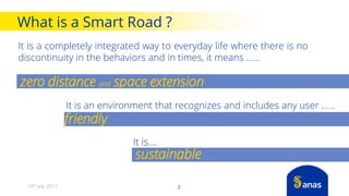
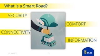
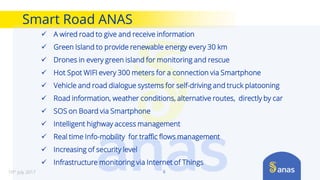
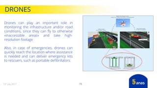
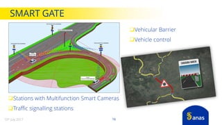
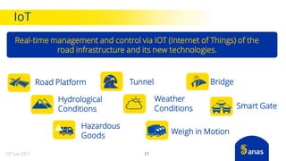
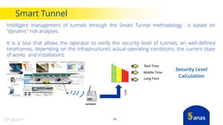
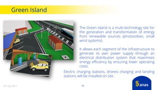
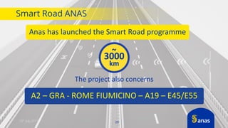
SMART ROAD
The innovative road
that runs with progress
What is a Smart Road ?
It is a completely integrated way to everyday life where there is no
discontinuity in the behaviors and in times, it means ......
2
It is an environment that recognizes and includes any user ……
It is….
zero distance and space extension
friendly
sustainable
10th July 2017
What is a Smart Road?
SECURITY
3
INFORMATION
COMFORT
CONNECTIVITY
10th July 2017
High prices
Technology can fail
The system does not work
Computer systems may be violated
Unclear attribution of responsibility
Integration with infrastructures
lacking this kind of technology
Driving not equal to that
of a human being
Data privacy
Must learn how to use
this specific technology
CONS
High Medium Low None
Safe driving
Fuel savings
Insurance savings
More comfortable driving experience
Less traffic
Time saving
Relax while driving
Use of new technologies
People without a drivers license
Work in the car
Sleep in the car
PROS
Medium Low None
*Source: Bain & Company
High
Smart Road is Autonomous Driving
10th July 20174
10th July 2017
Smart Road ANAS
A safe road, with Advanced Driver Assistance Systems, Autonomous Driving and
Intelligent Transport Systems
Connectivity with Users and Vehicles
Structural health monitoring
Info-mobility in real time
Green Technology
Sustenaibility
Vision
5
Smart Road ANAS
6
 A wired road to give and receive information
 Green Island to provide renewable energy every 30 km
 Drones in every green island for monitoring and rescue
 Hot Spot WIFI every 300 meters for a connection via Smartphone
 Vehicle and road dialogue systems for self-driving and truck platooning
 Road information, weather conditions, alternative routes, directly by car
 SOS on Board via Smartphone
 Intelligent highway access management
 Real time Info-mobility for traffic flows management
 Increasing of security level
 Infrastructure monitoring via Internet of Things
10th July 2017
Exchange of information between users and infrastructure. Access
Points distributed along the road infrastructure for reliable
connections with mobile devices in motion at motorway speeds
CONNECTIVITY
Wi-Fi
in motion
7
Wi-Fi
Vehicle To Infrastructure
DSRC- ETSI ITS-G5
Exchange of information between vehicles and
infrastructure:
• OBU (On Board Unit): equipment for Wi-Fi connectivity
on board the vehicle
• RSU (Road Side Unit): equipment for Wi-Fi connectivity
distributed throughout the road infrastructure
10th July 2017
Moving Wi-fi
8
Clients can now use various services, safely and
according to traffic laws
 SAFETY
 INFO-MOBILITY
 WEATHER CONDITIONS
 SOS ON BOARD
 LOGISTIC SERVICES
All services are available through APPs which will ONLY be
activated in voice mode while vehicles are moving,
offering full usability when the vehicles are motionless
10th July 2017
 Speed
 Acceleration / Deceleration
 Temperature, Pression, Humidity
 Localization (Gps)
 Magnetic Sensor
 Tilt Sensor
 Proximity, light (phone usage)
 Phone Provider and Network (3G, 4G,…)
 Language/Nationality
 Mobile Device Model
 Operating System
SmartPhone Sensing
910th July 2017
SmartPhone Sensing
1010th July 2017
Wi-Fi Eleven P and The European Strategy on C-ITS Systems
Applications Categories Applications Tasks Day C-ITS Services List
Active Road Safety
Assisted Driving/ Road Safety
Information
Signaling the presence of emergency vehicles Day 1 C-ITS Services List
Signaling the presence of slow-moving vehicle Day 1 C-ITS Services List
Collision alert nearby interchange Day 1 C-ITS Services List
Signaling the presence of Motocycle
Assisted Driving/ Warning
Signalling
Electronic emergency stop light Day 1 C-ITS Services List
Against-traffic-flow driving alert
Signaling the presence of vehicle involved in accident Day 1 C-ITS Services List
Signaling the presence of broken-up vehicle Day 1 C-ITS Services List
Traffic Conditions Day 1 C-ITS Services List
Detection of any road sign violation Day 1 C-ITS Services List
Signaling the presence of construction site Day 1 C-ITS Services List
Alert risk of accident Day 1 C-ITS Services List
Data from the vehicle / dangerous place
Data from the vehicle / rainfall
Data from the vehicle / road friction
Data from the vehicle / visibility
Data from the vehicle / wind
Traffic Efficiency
Speed Management Notification of speed limits Day 1 C-ITS Services List
Cooperative Navigation
Traffic information and recommended road routes Day 1.5 C-ITS Services List
Signalling road sections closed / Alternative routes Day 1.5 C-ITS Services List
Assisted navigation
Repetition of road signs in the vehicle Day 1.5 C-ITS Services List
Local Cooperative Services
Services based on location
monitoring
Notification of points of interest Day 1.5 C-ITS Services List
Automatic parking areas access control and management Day 1.5 C-ITS Services List
Internet Services Connectivity Services
Insurance/ Financial services Day 1.5 C-ITS Services List
Vehicles fleet management
10th July 2017 11
"Smart" Surveillance Activities with detection of hazardous events and critical
situations on the road and traffic data, equipped with a remote focus function,
with the capacity of taking footage day and night in all weather conditions
Traffic Flow condition
Traffic Congestion
Motionless vehicle (accident, etc.)
Slow vehicle
Vehicle moving in the opposite direction
Pedestrian on the road
Smoke or Fog on the road
Thing on the road
Automatic number plate recognition
Lane change
real-time traffic (average speed, traffic data,
lane occupancy, vehicle classification, etc.).
Kemler code plate recognition
INFORMATION FROM ROAD
1210th July 2017
Real-time information on roadwork areas, routes, access and road
maintenance operations that restrict traffic and can create queues or critical
situation to road users.
A device equipped with a GPS position sensor, triaxial accelerometer, capable of
detecting collisions/ rollovers/ change of position and on/off manual switches. The
device will communicate data by means of wireless systems with the ability to remotely
communicate its position at least every hour and at every change of position.
INFORMATION FROM ROAD
1310th July 2017
Sustainable Transport
1410th July 2017
DRONES
15
Drones can play an important role in
monitoring the infrastructure and/or road
conditions, since they can fly to otherwise
«inaccessible areas» and take high-
resolution footage.
Also, in case of emergencies, drones can
quickly reach the location where assistance
is needed and can deliver emergency kits
to rescuers, such as portable defibrillators.
10th July 2017
Vehicular Barrier
Vehicle control
Stations with Multifunction Smart Cameras
Traffic signalling stations
16
SMART GATE
10th July 2017
Real-time management and control via IOT (Internet of Things) of the
road infrastructure and its new technologies.
Weigh in Motion
Road Platform Tunnel
Smart Gate
Hydrological
Conditions
Bridge
Weather
Conditions
Hazardous
Goods
IoT
1710th July 2017
Intelligent management of tunnels through the Smart Tunnel methodology is based on
"dynamic" risk analyses
It is a tool that allows the operator to verify the security level of tunnels, on well-defined
timeframes, depending on the infrastructure’s actual operating conditions, the current state
of works and installations
GATEWAY
Security Level
Calculation
Real Time
Middle Time
Long Time
Link
Smart Tunnel
1810th July 2017
The Green Island is a multi-technology site for
the generation and transformation of energy
from renewable sources (photovoltaic, small
wind systems).
It allows each segment of the infrastructure to
generate its own power supply through an
electrical distribution system that maximises
energy efficiency by ensuring lower operating
costs.
Electric charging stations, drones charging and landing
stations will be installed on site.
Green Island
1910th July 2017
10th July 2017 20
Smart Road ANAS
Anas has launched the Smart Road programme
The project also concerns
A2 – GRA - ROME FIUMICINO – A19 – E45/E55
~
3000
km
WWW.STRADEANAS.IT
anas@postacert.stradeanas.it
Via Monzambano 10, 00185 Rome ITALY

THE ANAS SMART ROAD

  • 1.
    SMART ROAD The innovativeroad that runs with progress
  • 2.
    What is aSmart Road ? It is a completely integrated way to everyday life where there is no discontinuity in the behaviors and in times, it means ...... 2 It is an environment that recognizes and includes any user …… It is…. zero distance and space extension friendly sustainable 10th July 2017
  • 3.
    What is aSmart Road? SECURITY 3 INFORMATION COMFORT CONNECTIVITY 10th July 2017
  • 4.
    High prices Technology canfail The system does not work Computer systems may be violated Unclear attribution of responsibility Integration with infrastructures lacking this kind of technology Driving not equal to that of a human being Data privacy Must learn how to use this specific technology CONS High Medium Low None Safe driving Fuel savings Insurance savings More comfortable driving experience Less traffic Time saving Relax while driving Use of new technologies People without a drivers license Work in the car Sleep in the car PROS Medium Low None *Source: Bain & Company High Smart Road is Autonomous Driving 10th July 20174
  • 5.
    10th July 2017 SmartRoad ANAS A safe road, with Advanced Driver Assistance Systems, Autonomous Driving and Intelligent Transport Systems Connectivity with Users and Vehicles Structural health monitoring Info-mobility in real time Green Technology Sustenaibility Vision 5
  • 6.
    Smart Road ANAS 6 A wired road to give and receive information  Green Island to provide renewable energy every 30 km  Drones in every green island for monitoring and rescue  Hot Spot WIFI every 300 meters for a connection via Smartphone  Vehicle and road dialogue systems for self-driving and truck platooning  Road information, weather conditions, alternative routes, directly by car  SOS on Board via Smartphone  Intelligent highway access management  Real time Info-mobility for traffic flows management  Increasing of security level  Infrastructure monitoring via Internet of Things 10th July 2017
  • 7.
    Exchange of informationbetween users and infrastructure. Access Points distributed along the road infrastructure for reliable connections with mobile devices in motion at motorway speeds CONNECTIVITY Wi-Fi in motion 7 Wi-Fi Vehicle To Infrastructure DSRC- ETSI ITS-G5 Exchange of information between vehicles and infrastructure: • OBU (On Board Unit): equipment for Wi-Fi connectivity on board the vehicle • RSU (Road Side Unit): equipment for Wi-Fi connectivity distributed throughout the road infrastructure 10th July 2017
  • 8.
    Moving Wi-fi 8 Clients cannow use various services, safely and according to traffic laws  SAFETY  INFO-MOBILITY  WEATHER CONDITIONS  SOS ON BOARD  LOGISTIC SERVICES All services are available through APPs which will ONLY be activated in voice mode while vehicles are moving, offering full usability when the vehicles are motionless 10th July 2017
  • 9.
     Speed  Acceleration/ Deceleration  Temperature, Pression, Humidity  Localization (Gps)  Magnetic Sensor  Tilt Sensor  Proximity, light (phone usage)  Phone Provider and Network (3G, 4G,…)  Language/Nationality  Mobile Device Model  Operating System SmartPhone Sensing 910th July 2017
  • 10.
  • 11.
    Wi-Fi Eleven Pand The European Strategy on C-ITS Systems Applications Categories Applications Tasks Day C-ITS Services List Active Road Safety Assisted Driving/ Road Safety Information Signaling the presence of emergency vehicles Day 1 C-ITS Services List Signaling the presence of slow-moving vehicle Day 1 C-ITS Services List Collision alert nearby interchange Day 1 C-ITS Services List Signaling the presence of Motocycle Assisted Driving/ Warning Signalling Electronic emergency stop light Day 1 C-ITS Services List Against-traffic-flow driving alert Signaling the presence of vehicle involved in accident Day 1 C-ITS Services List Signaling the presence of broken-up vehicle Day 1 C-ITS Services List Traffic Conditions Day 1 C-ITS Services List Detection of any road sign violation Day 1 C-ITS Services List Signaling the presence of construction site Day 1 C-ITS Services List Alert risk of accident Day 1 C-ITS Services List Data from the vehicle / dangerous place Data from the vehicle / rainfall Data from the vehicle / road friction Data from the vehicle / visibility Data from the vehicle / wind Traffic Efficiency Speed Management Notification of speed limits Day 1 C-ITS Services List Cooperative Navigation Traffic information and recommended road routes Day 1.5 C-ITS Services List Signalling road sections closed / Alternative routes Day 1.5 C-ITS Services List Assisted navigation Repetition of road signs in the vehicle Day 1.5 C-ITS Services List Local Cooperative Services Services based on location monitoring Notification of points of interest Day 1.5 C-ITS Services List Automatic parking areas access control and management Day 1.5 C-ITS Services List Internet Services Connectivity Services Insurance/ Financial services Day 1.5 C-ITS Services List Vehicles fleet management 10th July 2017 11
  • 12.
    "Smart" Surveillance Activitieswith detection of hazardous events and critical situations on the road and traffic data, equipped with a remote focus function, with the capacity of taking footage day and night in all weather conditions Traffic Flow condition Traffic Congestion Motionless vehicle (accident, etc.) Slow vehicle Vehicle moving in the opposite direction Pedestrian on the road Smoke or Fog on the road Thing on the road Automatic number plate recognition Lane change real-time traffic (average speed, traffic data, lane occupancy, vehicle classification, etc.). Kemler code plate recognition INFORMATION FROM ROAD 1210th July 2017
  • 13.
    Real-time information onroadwork areas, routes, access and road maintenance operations that restrict traffic and can create queues or critical situation to road users. A device equipped with a GPS position sensor, triaxial accelerometer, capable of detecting collisions/ rollovers/ change of position and on/off manual switches. The device will communicate data by means of wireless systems with the ability to remotely communicate its position at least every hour and at every change of position. INFORMATION FROM ROAD 1310th July 2017
  • 14.
  • 15.
    DRONES 15 Drones can playan important role in monitoring the infrastructure and/or road conditions, since they can fly to otherwise «inaccessible areas» and take high- resolution footage. Also, in case of emergencies, drones can quickly reach the location where assistance is needed and can deliver emergency kits to rescuers, such as portable defibrillators. 10th July 2017
  • 16.
    Vehicular Barrier Vehicle control Stationswith Multifunction Smart Cameras Traffic signalling stations 16 SMART GATE 10th July 2017
  • 17.
    Real-time management andcontrol via IOT (Internet of Things) of the road infrastructure and its new technologies. Weigh in Motion Road Platform Tunnel Smart Gate Hydrological Conditions Bridge Weather Conditions Hazardous Goods IoT 1710th July 2017
  • 18.
    Intelligent management oftunnels through the Smart Tunnel methodology is based on "dynamic" risk analyses It is a tool that allows the operator to verify the security level of tunnels, on well-defined timeframes, depending on the infrastructure’s actual operating conditions, the current state of works and installations GATEWAY Security Level Calculation Real Time Middle Time Long Time Link Smart Tunnel 1810th July 2017
  • 19.
    The Green Islandis a multi-technology site for the generation and transformation of energy from renewable sources (photovoltaic, small wind systems). It allows each segment of the infrastructure to generate its own power supply through an electrical distribution system that maximises energy efficiency by ensuring lower operating costs. Electric charging stations, drones charging and landing stations will be installed on site. Green Island 1910th July 2017
  • 20.
    10th July 201720 Smart Road ANAS Anas has launched the Smart Road programme The project also concerns A2 – GRA - ROME FIUMICINO – A19 – E45/E55 ~ 3000 km
  • 21.