SlideShare a Scribd company logo
Thailand
Region South-eastern Asia
Population 69183
Surface area (km2) 513120
Population Density (per km2, 2018 135.4
Sex ratio 95
Population in capital city (2018) 10156
Source: Thailand. (n.d.). Retrieved August 14, 2019, from UN: http://data.un.org/en/iso/th.html
Introduction
Thailand, officially the Kingdom of Thailand and formerly known as Siam, is a country
at the centre of the Southeast Asian Indochinese peninsula composed of 76 provinces.
Thailand is the world's 50th-largest country by total area and the 21st-most-populous
country. The capital and largest city is Bangkok, a special administrative area.
Geography of Thailand
Total Land area: 513 120 sq km
Thailand, which has about the same
land area as Spain or France, consists
of two broad geographic areas: a
larger main section in the north and a
smaller peninsular extension in the
south.
The main body of the country is
surrounded by Myanmar (Burma) to
the west, Laos to the north and east,
Cambodia to the southeast, and the
Gulf of Thailand to the south.
Peninsular Thailand stretches
southward from the southwestern
corner of the country along the eastern
edge of the Malay Peninsula;
Myanmar extends along the western
portion of the peninsula
Relief of Thailand
Thailand straddles the area between
two mountain systems: the Central
Cordillera and the Cordillera of
Annam – these are two of the four
systems that fan out southwards from
the Yunnan Knot.
The Central Cordillera gives Thailand
its mountains in the north and west,
and continues on into the Peninsular
South and Malaysia.
The Cordillera of Annam provides the
mountains east of Thailand, on the
boundary with Laos and beyond. The
wide depression between these two
mountain systems contains the alluvial
plains of the Chao Phraya and the
Khorat Plain or the Northeast Plateau.
Plate tectonic theory places Thailand
on an inner perimeter of the Southeast
Asia Plate, which is being compressed
from opposite directions by the Indian
Plate to its west and the Philippine
Plate to its east.
Relief of Thailand
Continuing plate movements exert
immense pressure and generate
intense heat, capable of transfiguring
the tranquil landscape and the
subterranean resources.
Based upon the precepts of structural
geology, Thailand is divided into four
domains:
- the folded belt of mountains in the
north, west, and south of the country;
- the folded belt of mountains east of
the Chao Phraya Plain, delimiting it
against the higher Khorat Plain and
continuing eastward to delineate lower
Kampuchea (Cambodia);
- the Korat Plain with two major
basins; and- the Chao Phraya alluvial
plain, with two major basins and a
southerly continuation into the Gulf of
Thailand. Moormann and
Rojanasoonthon (1968) divided
Thailand into six
Relief of Thailand
Thailand’s landscapes vary from low
mountains to fertile alluvial plains
dotted with rice paddies to sandy
beaches set amid the equatorial
latitudes of the Asian monsoons. The
country is divided into five distinct
physiographic regions:
1. The Central Plain.
2. Southeastern coast
3. Northeeastern Plateau
4. Central Highlands
5. North and west continental
Highlands
6. Peninsular Thailand
Central Plain
This region occupies the lower central
part of Thailand; it is bordered by hilly
areas to the east, north and west, and
by the Gulf of Thailand to the south.
The south-central part of the region is
occupied by the broad alluvial delta of
the Chao Phraya River system, and is
known as the Bangkok Plain.
The surface layers of the Bangkok
Plain are composed of recent and
semi-recent alluvial deposits
at least the lower reaches of these
terraces are found to be of marine
origin, but farther north they appear to
be mainly composed of overlapping
alluvial fans from the surrounding
highlands.
Isolated hills are scattered through the
marginal and northern parts of the
Central Plain.
Southeast Coast
This region is bordered to the north by
hills, to the south and west by the Gulf
of Thailand, and to the east by the
Banthat Range.
The east-central part of the region is
formed by dissected highlands, which
are a continuation of the Cardaman
Mountains of southwest Kampuchea.
Surrounding these highlands are
quaternary terraces, mainly of marine
origin, in the western and southern
part of the region.
Shallow terrace formations, probably
river deposited, are found in the
northern part of the region
Along the coast, however, small non-
connecting marine and brackish water
alluvial plains occur. A minor, but
nevertheless important, landscapein
this physiographic region is the
volcanic plateau, west of Chanthaburi
in the Thai. Mai district
Northeast Plateau
The Northeast Plateau is composed
mainly of the broad river terraces of
the Mekong and its tributaries.
This region is bordered to the west by
the hills and plateau of the Central
Highlands, and to the north and east
by the Mekong River.
The main landscape features are the
quaternary river terraces, of which
three important levels have been
recognized, i.e. the low, middle and
high terraces.
The low terrace is dominant in the
catchment area of the Mun River
system. The northern part of the
plateau is predominantly occupied by
middle terraces. Isolated remnants of
high terrace are found in many places
on the Northeast Plateau
Volcanic outcrops and cones are found
south of the Mun River.
Central Highlands
This region has a complex
physiography, including diverging
landscape elements such as hills,
plateaus, peneplains, and a number of
valleys, of which the Pa Sak River
Valley is the most important. The
Central Highlands are bordered to the
east by the Northeast Plateau and to
the west by the North and West
Continental Highlands, the Central
Plain, and the Southeast Coast.
The northern portion of the region is
mainly composed of hills and more or
less strongly incised plateau or
peneplains, found at varying levels
from approximately 1,200 to about
300 m. The middle portion of the
region is an area of low undulating
peneplains, interrupted by steep
limestone ridges and buttes.
Central Highlands
North of Chai Badan, an important
volcanic area is found, the central
hilly part of which is surrounded by
rolling to undulating terrains.
The southeastern portion of the
Central Highlands includes mainly
hilly lands with incised plateaus.
North and West Continental
Highlands
This region is usually subdivided into
two subregions, i.e. the western
mountains and the northern hills and
valleys. The western mountains
consist of part of the rugged Central
Cordillera along the Thai-Burma
border into the peninsula
Several sub-parallel ridges, divided by
narrow and deep valleys are
recognized.
The northern hills and valleys
constitute a region of parallel north-
south oriented hill ridges and high
plateaus, alternating with elongated
level-floored basins. In the western
part of the sub-region, most of the
land is hilly to mountainous, with
wide incised plateaus and with narrow
inter-montane valleys.
North and West Continental
Highlands
To the east, the valleys are relatively
more important; the main ones being
those of Chiang Mai, Chiang Rai,
Lampang, Phrae and Nan. Three larger
steep limestone areas and a number of
craggy limestone ridges are found in
the hilly parts
Peninsular Thailand
This region is characterized by a number
of distinct ranges of hills and mountains
en echelon. The two principal ones are
the Phuket range on the west of the
Peninsula, and the Nakhon Si Thammarat
range, and continuing into Malaysia,
west of Padang Besar.
The landscape between the main ranges
is mainly made up of lower hills and of
undulating terraces, principally of
fluviatile origin.
On the west coast, the coastal terraces
and plains are narrow, with the
mountains extending down to the sea in
many places. This coast is indented with
many drowned estuaries.
The east coast is smooth, with wider
coastal terraces and plains. The largest
coastal plain of Peninsular Thailand
stretches from Nakhon Si Thammarat to
Songkhla, including important elongated
beaches and a large lagoon, the Tha-le
Sap or Songkhla Lake.
Rivers of Thailand
Thailand is drained largely by two
river systems: the Chao Phraya in the
west and the Mekong in the east.
Three major rivers in the northern
mountains—from west to east, the
Ping (and its tributary the Wang), the
Yom, and the Nan—flow generally
south through narrow valleys to the
plains and then merge to form the
Chao Phraya, Thailand’s principal
river.
The rivers of the Khorat Plateau flow
generally southeastward and empty
into the Mekong. Floodwaters from
these rivers have been important
sources of water for rice production in
the area.
The southeast and the peninsula are
drained by short streams and rivers. In
the southeast the rivers in the north
flow into the Chao Phraya delta, while
those in the west and south run
directly into the sea, where they have
built up small alluvial basins and
deltas along the coast
4-5 km
Soils of Thailand
The great alluvial deposits in the river
valleys contain the most fertile soils in
Thailand and are replenished annually
with sediment washed down by rivers
swollen with the annual monsoon rains.
Chief among these areas is the delta
floodplain of the Chao Phraya, but the
relatively flat basins in the northern
mountains, scattered lands along the
Mun and Chi rivers on the Khorat
Plateau, and much of the coast also
have rich alluvial soils. Soils elsewhere
tend to be relatively infertile, highly
leached laterites. Near the Mekong, a
high salt content in some soils limits
crop production, although salt deposits
there are mined commercially.
Climate of Thailand
The major influences on
Thailand’s climate are its
location in the tropical
monsoon zone of mainland
Southeast Asia and certain
topographic features that
affect the distribution of
precipitation.
Beginning in May, the warm,
humid air masses of the
southwest monsoon flow
north-eastward over the
region from the Indian Ocean,
depositing great quantities of
precipitation.
Nationwide, temperatures are
relatively steady throughout
the year, averaging between
77 and 84 °F (25 and 29 °C).
Rock formation of Southern Bay
Limestone in the bay is a
mono-mineralic (one mineral)
rock consisting of a single
mineral (calcite) which can
make up 95% of the rock.
Other rocks found in marine
limestone include dolomite,
siderite, quartz, feldspar,
mica, and various clay
materials.
Fragments from the hard parts
of marine animals and plants,
the parts which contain
calcium, form the sediment.
Water sets in pools on top of
the islands. It percolates
down through cracks in the
rocks. It dissolves limestone
as it goes, thus enlarging the
cracks.
The sides of this "sink hole"
erode and dissolve. If a sea
cave happens to connect with
this hole, the enlarging
process is sped up by the
action of the sea water.
Recent History of Natural Disaster
Floods – May 2017
High amounts of Rain caused floods and flash
floods in the northern provinces of Thailand
Floods- December 2016
The southern provinces of Surat
Thani,Nakhon Si Thammarat Songkhla,
Phattalung,Pattani, Chumphon, Krabi, Trang,
Yala andNarathiwat were struck by floods
Fires- May 2016
Fires spread in the forested areas of Chiang
Mai, Mae Hong Son, Tak and Nan provinces.
Floods - October 2016
Floods that hit Nakhon Sawan province killed
three people and inundated large areas of
farmland as well as almost 30,000 homes.
Drought – February 2016
The Government of Thailand reported that 28
provinces in Thailand were at risk of water
shortages
Drought - July 2015
Thailand experienced one of the worst
droughts in decades, with water rationing
imposed in almost a third of the country
Landslides - July 2014
After three days of heavy rain, Chiang Rai
province was struck by flash floods and
landslides
Typhoon – July 2014
Typhoon Rammasun caused torrential
rainfall in Northeastern Thailand, with
Yasothon province being the most affected
Earthquake - May 2014
On May 5, a 6.3 on the Richter scale
earthquake, with its epicenter 27km
southwest of Chiang Rai, struck Thailand
Floods - October 2013
From July to October northern Thailand
experienced sporadic floods.
Floods of 2011
Flooding was triggered by heavy monsoon
rains in July 2011 and provinces were
affected over a three-month period (July-
September).
Bibliography
Physical envoirnment of Thailand. (2014). Retrieved August 20, 2019, from Land
Development Department: https://www.ldd.go.th/ldd_en/en-US/physiographic-regions/
Assistance, C. f. (2018). Thailand Disaster Management Reference Handbook . Hickam,
Hawaii: Center for Excellence in Disaster Management and Humanitairan Assistance.
Keyes, J. A. (2019, August 18). Thailand. Retrieved August 20, 2019, from Encyclopaedia
Britannica: https://www.britannica.com/place/Thailand
Thailand. (n.d.). Retrieved August 14, 2019, from UN: http://data.un.org/en/iso/th.html

More Related Content

What's hot

Thailand’s Economy
Thailand’s EconomyThailand’s Economy
Thailand’s Economy
marcpeter
 
Bangkok Thailand
Bangkok ThailandBangkok Thailand
Bangkok ThailandCory Plough
 
Thailand analysis of the economic, commercial and social environment 2020
Thailand analysis of the economic, commercial and social environment 2020Thailand analysis of the economic, commercial and social environment 2020
Thailand analysis of the economic, commercial and social environment 2020
Juan Inoriza
 
ระเบียบวิธีวิจัย
ระเบียบวิธีวิจัยระเบียบวิธีวิจัย
ระเบียบวิธีวิจัย
Similun_maya
 
บทเรียนสำเร็จรูป เรื่อง-แผนที่
บทเรียนสำเร็จรูป เรื่อง-แผนที่บทเรียนสำเร็จรูป เรื่อง-แผนที่
บทเรียนสำเร็จรูป เรื่อง-แผนที่
ครูอ้อ วิรยา
 
Thailand
ThailandThailand
Thailand
Gokul Krishna
 
Vietnam Tourism
Vietnam TourismVietnam Tourism
Vietnam Tourism
Phuong Nguyen
 
ภูมิศาสตร์ประเทศไทย4
ภูมิศาสตร์ประเทศไทย4ภูมิศาสตร์ประเทศไทย4
ภูมิศาสตร์ประเทศไทย4
wittawat_name
 
Country profile - Thailand
Country profile - ThailandCountry profile - Thailand
Country profile - Thailand
Veronica Gelfgren
 
เปรียบเทียบการศึกษาไทย ญี่ปุ่น
เปรียบเทียบการศึกษาไทย ญี่ปุ่นเปรียบเทียบการศึกษาไทย ญี่ปุ่น
เปรียบเทียบการศึกษาไทย ญี่ปุ่น
Kingkarn Saowalak
 
ภูมิศาสตร์ประเทศไทย22
ภูมิศาสตร์ประเทศไทย22ภูมิศาสตร์ประเทศไทย22
ภูมิศาสตร์ประเทศไทย22Nongruk Srisukha
 
thailand-wed 1:30pm tutorial
thailand-wed 1:30pm tutorialthailand-wed 1:30pm tutorial
thailand-wed 1:30pm tutorialthainess
 
10 Facts about Japan - PEOPLE
10 Facts about Japan - PEOPLE10 Facts about Japan - PEOPLE
10 Facts about Japan - PEOPLE
LiviaMihai
 
Thailand
ThailandThailand
Thailand
John Ferreria
 
ประวัติศาสตร์ทวีปอเมริกาเหนือ
ประวัติศาสตร์ทวีปอเมริกาเหนือประวัติศาสตร์ทวีปอเมริกาเหนือ
ประวัติศาสตร์ทวีปอเมริกาเหนือ
Pann Boonthong
 
10 นวัตกรรมการพัฒนาเมืองอย่างยั่งยืนประจำปี 2015
10 นวัตกรรมการพัฒนาเมืองอย่างยั่งยืนประจำปี 201510 นวัตกรรมการพัฒนาเมืองอย่างยั่งยืนประจำปี 2015
10 นวัตกรรมการพัฒนาเมืองอย่างยั่งยืนประจำปี 2015
Klangpanya
 
Thailand Presentation
Thailand PresentationThailand Presentation
Thailand Presentation
Ellen Underwood
 

What's hot (20)

Thailand’s Economy
Thailand’s EconomyThailand’s Economy
Thailand’s Economy
 
Bangkok Thailand
Bangkok ThailandBangkok Thailand
Bangkok Thailand
 
Thailand analysis of the economic, commercial and social environment 2020
Thailand analysis of the economic, commercial and social environment 2020Thailand analysis of the economic, commercial and social environment 2020
Thailand analysis of the economic, commercial and social environment 2020
 
Politics of Thailand
Politics of ThailandPolitics of Thailand
Politics of Thailand
 
ระเบียบวิธีวิจัย
ระเบียบวิธีวิจัยระเบียบวิธีวิจัย
ระเบียบวิธีวิจัย
 
บทเรียนสำเร็จรูป เรื่อง-แผนที่
บทเรียนสำเร็จรูป เรื่อง-แผนที่บทเรียนสำเร็จรูป เรื่อง-แผนที่
บทเรียนสำเร็จรูป เรื่อง-แผนที่
 
Thailand
ThailandThailand
Thailand
 
Vietnam Tourism
Vietnam TourismVietnam Tourism
Vietnam Tourism
 
ภูมิศาสตร์กายภาพประเทศไทย
ภูมิศาสตร์กายภาพประเทศไทยภูมิศาสตร์กายภาพประเทศไทย
ภูมิศาสตร์กายภาพประเทศไทย
 
ภูมิศาสตร์ประเทศไทย4
ภูมิศาสตร์ประเทศไทย4ภูมิศาสตร์ประเทศไทย4
ภูมิศาสตร์ประเทศไทย4
 
Country profile - Thailand
Country profile - ThailandCountry profile - Thailand
Country profile - Thailand
 
Thai
ThaiThai
Thai
 
เปรียบเทียบการศึกษาไทย ญี่ปุ่น
เปรียบเทียบการศึกษาไทย ญี่ปุ่นเปรียบเทียบการศึกษาไทย ญี่ปุ่น
เปรียบเทียบการศึกษาไทย ญี่ปุ่น
 
ภูมิศาสตร์ประเทศไทย22
ภูมิศาสตร์ประเทศไทย22ภูมิศาสตร์ประเทศไทย22
ภูมิศาสตร์ประเทศไทย22
 
thailand-wed 1:30pm tutorial
thailand-wed 1:30pm tutorialthailand-wed 1:30pm tutorial
thailand-wed 1:30pm tutorial
 
10 Facts about Japan - PEOPLE
10 Facts about Japan - PEOPLE10 Facts about Japan - PEOPLE
10 Facts about Japan - PEOPLE
 
Thailand
ThailandThailand
Thailand
 
ประวัติศาสตร์ทวีปอเมริกาเหนือ
ประวัติศาสตร์ทวีปอเมริกาเหนือประวัติศาสตร์ทวีปอเมริกาเหนือ
ประวัติศาสตร์ทวีปอเมริกาเหนือ
 
10 นวัตกรรมการพัฒนาเมืองอย่างยั่งยืนประจำปี 2015
10 นวัตกรรมการพัฒนาเมืองอย่างยั่งยืนประจำปี 201510 นวัตกรรมการพัฒนาเมืองอย่างยั่งยืนประจำปี 2015
10 นวัตกรรมการพัฒนาเมืองอย่างยั่งยืนประจำปี 2015
 
Thailand Presentation
Thailand PresentationThailand Presentation
Thailand Presentation
 

Similar to Thailand geomorphlogy

Land of Thailand.pptx
Land of Thailand.pptxLand of Thailand.pptx
Land of Thailand.pptx
TiffannyDianeAgbayan
 
Southeast Asia Geography
Southeast Asia GeographySoutheast Asia Geography
Southeast Asia Geography
Chris Calvert
 
Sst ppt on physical features of india
Sst ppt on physical features of indiaSst ppt on physical features of india
Sst ppt on physical features of india
indrani97321
 
Sstppt
SstpptSstppt
Sstppt
DivyeAwasthi
 
Asia
AsiaAsia
Geography of Asia
Geography of Asia Geography of Asia
Geography of Asia
university of gujrat
 
Physical feature of india.ppt
Physical feature of india.pptPhysical feature of india.ppt
Physical feature of india.ppt
AyushDewangan20
 
East Asia 1
East Asia 1East Asia 1
East Asia 1
Mr. Philen
 
Geography of china
Geography of chinaGeography of china
Geography of chinaUUM
 
[Slideshare-Downloader-la]-649a802f32a57.pptx
[Slideshare-Downloader-la]-649a802f32a57.pptx[Slideshare-Downloader-la]-649a802f32a57.pptx
[Slideshare-Downloader-la]-649a802f32a57.pptx
RockstarLearnerz
 
Physical features of india
Physical features of indiaPhysical features of india
Physical features of india
SIBI V
 
India: size and location
India: size and locationIndia: size and location
India: size and locationkv1 halwara
 
India size and location
India size and locationIndia size and location
India size and location
kv
 
India size and location
India size and location India size and location
India size and location
Vishwesh B Koli
 
Physical feature of india by ayush dewangan 😘.pptx
Physical feature of india by ayush dewangan 😘.pptxPhysical feature of india by ayush dewangan 😘.pptx
Physical feature of india by ayush dewangan 😘.pptx
ayushDewangan19
 
Introducing asia
Introducing asiaIntroducing asia
Introducing asia
Thai Chamroeun
 
Ncert india physical
Ncert india physicalNcert india physical
Ncert india physical
Venu Gopal Kallem
 
Ch.2 Physical Features of India
Ch.2 Physical Features of India Ch.2 Physical Features of India
Ch.2 Physical Features of India
8821009262
 

Similar to Thailand geomorphlogy (20)

Land of Thailand.pptx
Land of Thailand.pptxLand of Thailand.pptx
Land of Thailand.pptx
 
Southeast Asia Geography
Southeast Asia GeographySoutheast Asia Geography
Southeast Asia Geography
 
Sst ppt on physical features of india
Sst ppt on physical features of indiaSst ppt on physical features of india
Sst ppt on physical features of india
 
Sstppt
SstpptSstppt
Sstppt
 
Asia
AsiaAsia
Asia
 
Geography of china
Geography of chinaGeography of china
Geography of china
 
Geography of Asia
Geography of Asia Geography of Asia
Geography of Asia
 
Physical feature of india.ppt
Physical feature of india.pptPhysical feature of india.ppt
Physical feature of india.ppt
 
East Asia 1
East Asia 1East Asia 1
East Asia 1
 
Geography of china
Geography of chinaGeography of china
Geography of china
 
[Slideshare-Downloader-la]-649a802f32a57.pptx
[Slideshare-Downloader-la]-649a802f32a57.pptx[Slideshare-Downloader-la]-649a802f32a57.pptx
[Slideshare-Downloader-la]-649a802f32a57.pptx
 
Physical features of india
Physical features of indiaPhysical features of india
Physical features of india
 
India: size and location
India: size and locationIndia: size and location
India: size and location
 
India size and location
India size and locationIndia size and location
India size and location
 
India size and location
India size and location India size and location
India size and location
 
Physical feature of india by ayush dewangan 😘.pptx
Physical feature of india by ayush dewangan 😘.pptxPhysical feature of india by ayush dewangan 😘.pptx
Physical feature of india by ayush dewangan 😘.pptx
 
Introducing asia
Introducing asiaIntroducing asia
Introducing asia
 
Ncert india physical
Ncert india physicalNcert india physical
Ncert india physical
 
Ch.2 Physical Features of India
Ch.2 Physical Features of India Ch.2 Physical Features of India
Ch.2 Physical Features of India
 
China
China China
China
 

More from Akhil Akash vadlamudi

Dan Kiley
Dan KileyDan Kiley
Estuaries
EstuariesEstuaries
Ntu singapore
Ntu singaporeNtu singapore
Ntu singapore
Akhil Akash vadlamudi
 
Commerzbank headquarters
Commerzbank headquartersCommerzbank headquarters
Commerzbank headquarters
Akhil Akash vadlamudi
 
Casa port railway station
Casa port railway stationCasa port railway station
Casa port railway station
Akhil Akash vadlamudi
 
Sanskriti Kendra
Sanskriti KendraSanskriti Kendra
Sanskriti Kendra
Akhil Akash vadlamudi
 
Beas and Parabati region
Beas and Parabati regionBeas and Parabati region
Beas and Parabati region
Akhil Akash vadlamudi
 
Sasaki associates
Sasaki associatesSasaki associates
Sasaki associates
Akhil Akash vadlamudi
 
Sikkim
SikkimSikkim

More from Akhil Akash vadlamudi (9)

Dan Kiley
Dan KileyDan Kiley
Dan Kiley
 
Estuaries
EstuariesEstuaries
Estuaries
 
Ntu singapore
Ntu singaporeNtu singapore
Ntu singapore
 
Commerzbank headquarters
Commerzbank headquartersCommerzbank headquarters
Commerzbank headquarters
 
Casa port railway station
Casa port railway stationCasa port railway station
Casa port railway station
 
Sanskriti Kendra
Sanskriti KendraSanskriti Kendra
Sanskriti Kendra
 
Beas and Parabati region
Beas and Parabati regionBeas and Parabati region
Beas and Parabati region
 
Sasaki associates
Sasaki associatesSasaki associates
Sasaki associates
 
Sikkim
SikkimSikkim
Sikkim
 

Recently uploaded

一比一原版(Bristol毕业证书)布里斯托大学毕业证成绩单如何办理
一比一原版(Bristol毕业证书)布里斯托大学毕业证成绩单如何办理一比一原版(Bristol毕业证书)布里斯托大学毕业证成绩单如何办理
一比一原版(Bristol毕业证书)布里斯托大学毕业证成绩单如何办理
smpc3nvg
 
Can AI do good? at 'offtheCanvas' India HCI prelude
Can AI do good? at 'offtheCanvas' India HCI preludeCan AI do good? at 'offtheCanvas' India HCI prelude
Can AI do good? at 'offtheCanvas' India HCI prelude
Alan Dix
 
Between Filth and Fortune- Urban Cattle Foraging Realities by Devi S Nair, An...
Between Filth and Fortune- Urban Cattle Foraging Realities by Devi S Nair, An...Between Filth and Fortune- Urban Cattle Foraging Realities by Devi S Nair, An...
Between Filth and Fortune- Urban Cattle Foraging Realities by Devi S Nair, An...
Mansi Shah
 
一比一原版(CITY毕业证书)谢菲尔德哈勒姆大学毕业证如何办理
一比一原版(CITY毕业证书)谢菲尔德哈勒姆大学毕业证如何办理一比一原版(CITY毕业证书)谢菲尔德哈勒姆大学毕业证如何办理
一比一原版(CITY毕业证书)谢菲尔德哈勒姆大学毕业证如何办理
9a93xvy
 
Design Thinking Design thinking Design thinking
Design Thinking Design thinking Design thinkingDesign Thinking Design thinking Design thinking
Design Thinking Design thinking Design thinking
cy0krjxt
 
Borys Sutkowski portfolio interior design
Borys Sutkowski portfolio interior designBorys Sutkowski portfolio interior design
Borys Sutkowski portfolio interior design
boryssutkowski
 
一比一原版(RHUL毕业证书)伦敦大学皇家霍洛威学院毕业证如何办理
一比一原版(RHUL毕业证书)伦敦大学皇家霍洛威学院毕业证如何办理一比一原版(RHUL毕业证书)伦敦大学皇家霍洛威学院毕业证如何办理
一比一原版(RHUL毕业证书)伦敦大学皇家霍洛威学院毕业证如何办理
9a93xvy
 
Design Thinking Design thinking Design thinking
Design Thinking Design thinking Design thinkingDesign Thinking Design thinking Design thinking
Design Thinking Design thinking Design thinking
cy0krjxt
 
Research 20 slides Amelia gavryliuks.pdf
Research 20 slides Amelia gavryliuks.pdfResearch 20 slides Amelia gavryliuks.pdf
Research 20 slides Amelia gavryliuks.pdf
ameli25062005
 
vernacular architecture in response to climate.pdf
vernacular architecture in response to climate.pdfvernacular architecture in response to climate.pdf
vernacular architecture in response to climate.pdf
PrabhjeetSingh219035
 
Portfolio.pdf
Portfolio.pdfPortfolio.pdf
Portfolio.pdf
garcese
 
Коричневый и Кремовый Деликатный Органический Копирайтер Фрилансер Марке...
Коричневый и Кремовый Деликатный Органический Копирайтер Фрилансер Марке...Коричневый и Кремовый Деликатный Органический Копирайтер Фрилансер Марке...
Коричневый и Кремовый Деликатный Органический Копирайтер Фрилансер Марке...
ameli25062005
 
Design Thinking Design thinking Design thinking
Design Thinking Design thinking Design thinkingDesign Thinking Design thinking Design thinking
Design Thinking Design thinking Design thinking
cy0krjxt
 
一比一原版(LSE毕业证书)伦敦政治经济学院毕业证成绩单如何办理
一比一原版(LSE毕业证书)伦敦政治经济学院毕业证成绩单如何办理一比一原版(LSE毕业证书)伦敦政治经济学院毕业证成绩单如何办理
一比一原版(LSE毕业证书)伦敦政治经济学院毕业证成绩单如何办理
jyz59f4j
 
PORTFOLIO FABIANA VILLANI ARCHITECTURE.pdf
PORTFOLIO FABIANA VILLANI ARCHITECTURE.pdfPORTFOLIO FABIANA VILLANI ARCHITECTURE.pdf
PORTFOLIO FABIANA VILLANI ARCHITECTURE.pdf
fabianavillanib
 
Mohannad Abdullah portfolio _ V2 _22-24
Mohannad Abdullah  portfolio _ V2 _22-24Mohannad Abdullah  portfolio _ V2 _22-24
Mohannad Abdullah portfolio _ V2 _22-24
M. A. Architect
 
White wonder, Work developed by Eva Tschopp
White wonder, Work developed by Eva TschoppWhite wonder, Work developed by Eva Tschopp
White wonder, Work developed by Eva Tschopp
Mansi Shah
 
20 slides of research movie and artists .pdf
20 slides of research movie and artists .pdf20 slides of research movie and artists .pdf
20 slides of research movie and artists .pdf
ameli25062005
 
一比一原版(NCL毕业证书)纽卡斯尔大学毕业证成绩单如何办理
一比一原版(NCL毕业证书)纽卡斯尔大学毕业证成绩单如何办理一比一原版(NCL毕业证书)纽卡斯尔大学毕业证成绩单如何办理
一比一原版(NCL毕业证书)纽卡斯尔大学毕业证成绩单如何办理
7sd8fier
 
Book Formatting: Quality Control Checks for Designers
Book Formatting: Quality Control Checks for DesignersBook Formatting: Quality Control Checks for Designers
Book Formatting: Quality Control Checks for Designers
Confidence Ago
 

Recently uploaded (20)

一比一原版(Bristol毕业证书)布里斯托大学毕业证成绩单如何办理
一比一原版(Bristol毕业证书)布里斯托大学毕业证成绩单如何办理一比一原版(Bristol毕业证书)布里斯托大学毕业证成绩单如何办理
一比一原版(Bristol毕业证书)布里斯托大学毕业证成绩单如何办理
 
Can AI do good? at 'offtheCanvas' India HCI prelude
Can AI do good? at 'offtheCanvas' India HCI preludeCan AI do good? at 'offtheCanvas' India HCI prelude
Can AI do good? at 'offtheCanvas' India HCI prelude
 
Between Filth and Fortune- Urban Cattle Foraging Realities by Devi S Nair, An...
Between Filth and Fortune- Urban Cattle Foraging Realities by Devi S Nair, An...Between Filth and Fortune- Urban Cattle Foraging Realities by Devi S Nair, An...
Between Filth and Fortune- Urban Cattle Foraging Realities by Devi S Nair, An...
 
一比一原版(CITY毕业证书)谢菲尔德哈勒姆大学毕业证如何办理
一比一原版(CITY毕业证书)谢菲尔德哈勒姆大学毕业证如何办理一比一原版(CITY毕业证书)谢菲尔德哈勒姆大学毕业证如何办理
一比一原版(CITY毕业证书)谢菲尔德哈勒姆大学毕业证如何办理
 
Design Thinking Design thinking Design thinking
Design Thinking Design thinking Design thinkingDesign Thinking Design thinking Design thinking
Design Thinking Design thinking Design thinking
 
Borys Sutkowski portfolio interior design
Borys Sutkowski portfolio interior designBorys Sutkowski portfolio interior design
Borys Sutkowski portfolio interior design
 
一比一原版(RHUL毕业证书)伦敦大学皇家霍洛威学院毕业证如何办理
一比一原版(RHUL毕业证书)伦敦大学皇家霍洛威学院毕业证如何办理一比一原版(RHUL毕业证书)伦敦大学皇家霍洛威学院毕业证如何办理
一比一原版(RHUL毕业证书)伦敦大学皇家霍洛威学院毕业证如何办理
 
Design Thinking Design thinking Design thinking
Design Thinking Design thinking Design thinkingDesign Thinking Design thinking Design thinking
Design Thinking Design thinking Design thinking
 
Research 20 slides Amelia gavryliuks.pdf
Research 20 slides Amelia gavryliuks.pdfResearch 20 slides Amelia gavryliuks.pdf
Research 20 slides Amelia gavryliuks.pdf
 
vernacular architecture in response to climate.pdf
vernacular architecture in response to climate.pdfvernacular architecture in response to climate.pdf
vernacular architecture in response to climate.pdf
 
Portfolio.pdf
Portfolio.pdfPortfolio.pdf
Portfolio.pdf
 
Коричневый и Кремовый Деликатный Органический Копирайтер Фрилансер Марке...
Коричневый и Кремовый Деликатный Органический Копирайтер Фрилансер Марке...Коричневый и Кремовый Деликатный Органический Копирайтер Фрилансер Марке...
Коричневый и Кремовый Деликатный Органический Копирайтер Фрилансер Марке...
 
Design Thinking Design thinking Design thinking
Design Thinking Design thinking Design thinkingDesign Thinking Design thinking Design thinking
Design Thinking Design thinking Design thinking
 
一比一原版(LSE毕业证书)伦敦政治经济学院毕业证成绩单如何办理
一比一原版(LSE毕业证书)伦敦政治经济学院毕业证成绩单如何办理一比一原版(LSE毕业证书)伦敦政治经济学院毕业证成绩单如何办理
一比一原版(LSE毕业证书)伦敦政治经济学院毕业证成绩单如何办理
 
PORTFOLIO FABIANA VILLANI ARCHITECTURE.pdf
PORTFOLIO FABIANA VILLANI ARCHITECTURE.pdfPORTFOLIO FABIANA VILLANI ARCHITECTURE.pdf
PORTFOLIO FABIANA VILLANI ARCHITECTURE.pdf
 
Mohannad Abdullah portfolio _ V2 _22-24
Mohannad Abdullah  portfolio _ V2 _22-24Mohannad Abdullah  portfolio _ V2 _22-24
Mohannad Abdullah portfolio _ V2 _22-24
 
White wonder, Work developed by Eva Tschopp
White wonder, Work developed by Eva TschoppWhite wonder, Work developed by Eva Tschopp
White wonder, Work developed by Eva Tschopp
 
20 slides of research movie and artists .pdf
20 slides of research movie and artists .pdf20 slides of research movie and artists .pdf
20 slides of research movie and artists .pdf
 
一比一原版(NCL毕业证书)纽卡斯尔大学毕业证成绩单如何办理
一比一原版(NCL毕业证书)纽卡斯尔大学毕业证成绩单如何办理一比一原版(NCL毕业证书)纽卡斯尔大学毕业证成绩单如何办理
一比一原版(NCL毕业证书)纽卡斯尔大学毕业证成绩单如何办理
 
Book Formatting: Quality Control Checks for Designers
Book Formatting: Quality Control Checks for DesignersBook Formatting: Quality Control Checks for Designers
Book Formatting: Quality Control Checks for Designers
 

Thailand geomorphlogy

  • 2. Region South-eastern Asia Population 69183 Surface area (km2) 513120 Population Density (per km2, 2018 135.4 Sex ratio 95 Population in capital city (2018) 10156 Source: Thailand. (n.d.). Retrieved August 14, 2019, from UN: http://data.un.org/en/iso/th.html Introduction Thailand, officially the Kingdom of Thailand and formerly known as Siam, is a country at the centre of the Southeast Asian Indochinese peninsula composed of 76 provinces. Thailand is the world's 50th-largest country by total area and the 21st-most-populous country. The capital and largest city is Bangkok, a special administrative area.
  • 3. Geography of Thailand Total Land area: 513 120 sq km Thailand, which has about the same land area as Spain or France, consists of two broad geographic areas: a larger main section in the north and a smaller peninsular extension in the south. The main body of the country is surrounded by Myanmar (Burma) to the west, Laos to the north and east, Cambodia to the southeast, and the Gulf of Thailand to the south. Peninsular Thailand stretches southward from the southwestern corner of the country along the eastern edge of the Malay Peninsula; Myanmar extends along the western portion of the peninsula
  • 4. Relief of Thailand Thailand straddles the area between two mountain systems: the Central Cordillera and the Cordillera of Annam – these are two of the four systems that fan out southwards from the Yunnan Knot. The Central Cordillera gives Thailand its mountains in the north and west, and continues on into the Peninsular South and Malaysia. The Cordillera of Annam provides the mountains east of Thailand, on the boundary with Laos and beyond. The wide depression between these two mountain systems contains the alluvial plains of the Chao Phraya and the Khorat Plain or the Northeast Plateau. Plate tectonic theory places Thailand on an inner perimeter of the Southeast Asia Plate, which is being compressed from opposite directions by the Indian Plate to its west and the Philippine Plate to its east.
  • 5. Relief of Thailand Continuing plate movements exert immense pressure and generate intense heat, capable of transfiguring the tranquil landscape and the subterranean resources. Based upon the precepts of structural geology, Thailand is divided into four domains: - the folded belt of mountains in the north, west, and south of the country; - the folded belt of mountains east of the Chao Phraya Plain, delimiting it against the higher Khorat Plain and continuing eastward to delineate lower Kampuchea (Cambodia); - the Korat Plain with two major basins; and- the Chao Phraya alluvial plain, with two major basins and a southerly continuation into the Gulf of Thailand. Moormann and Rojanasoonthon (1968) divided Thailand into six
  • 6. Relief of Thailand Thailand’s landscapes vary from low mountains to fertile alluvial plains dotted with rice paddies to sandy beaches set amid the equatorial latitudes of the Asian monsoons. The country is divided into five distinct physiographic regions: 1. The Central Plain. 2. Southeastern coast 3. Northeeastern Plateau 4. Central Highlands 5. North and west continental Highlands 6. Peninsular Thailand
  • 7.
  • 8. Central Plain This region occupies the lower central part of Thailand; it is bordered by hilly areas to the east, north and west, and by the Gulf of Thailand to the south. The south-central part of the region is occupied by the broad alluvial delta of the Chao Phraya River system, and is known as the Bangkok Plain. The surface layers of the Bangkok Plain are composed of recent and semi-recent alluvial deposits at least the lower reaches of these terraces are found to be of marine origin, but farther north they appear to be mainly composed of overlapping alluvial fans from the surrounding highlands. Isolated hills are scattered through the marginal and northern parts of the Central Plain.
  • 9. Southeast Coast This region is bordered to the north by hills, to the south and west by the Gulf of Thailand, and to the east by the Banthat Range. The east-central part of the region is formed by dissected highlands, which are a continuation of the Cardaman Mountains of southwest Kampuchea. Surrounding these highlands are quaternary terraces, mainly of marine origin, in the western and southern part of the region. Shallow terrace formations, probably river deposited, are found in the northern part of the region Along the coast, however, small non- connecting marine and brackish water alluvial plains occur. A minor, but nevertheless important, landscapein this physiographic region is the volcanic plateau, west of Chanthaburi in the Thai. Mai district
  • 10. Northeast Plateau The Northeast Plateau is composed mainly of the broad river terraces of the Mekong and its tributaries. This region is bordered to the west by the hills and plateau of the Central Highlands, and to the north and east by the Mekong River. The main landscape features are the quaternary river terraces, of which three important levels have been recognized, i.e. the low, middle and high terraces. The low terrace is dominant in the catchment area of the Mun River system. The northern part of the plateau is predominantly occupied by middle terraces. Isolated remnants of high terrace are found in many places on the Northeast Plateau Volcanic outcrops and cones are found south of the Mun River.
  • 11. Central Highlands This region has a complex physiography, including diverging landscape elements such as hills, plateaus, peneplains, and a number of valleys, of which the Pa Sak River Valley is the most important. The Central Highlands are bordered to the east by the Northeast Plateau and to the west by the North and West Continental Highlands, the Central Plain, and the Southeast Coast. The northern portion of the region is mainly composed of hills and more or less strongly incised plateau or peneplains, found at varying levels from approximately 1,200 to about 300 m. The middle portion of the region is an area of low undulating peneplains, interrupted by steep limestone ridges and buttes.
  • 12. Central Highlands North of Chai Badan, an important volcanic area is found, the central hilly part of which is surrounded by rolling to undulating terrains. The southeastern portion of the Central Highlands includes mainly hilly lands with incised plateaus.
  • 13. North and West Continental Highlands This region is usually subdivided into two subregions, i.e. the western mountains and the northern hills and valleys. The western mountains consist of part of the rugged Central Cordillera along the Thai-Burma border into the peninsula Several sub-parallel ridges, divided by narrow and deep valleys are recognized. The northern hills and valleys constitute a region of parallel north- south oriented hill ridges and high plateaus, alternating with elongated level-floored basins. In the western part of the sub-region, most of the land is hilly to mountainous, with wide incised plateaus and with narrow inter-montane valleys.
  • 14. North and West Continental Highlands To the east, the valleys are relatively more important; the main ones being those of Chiang Mai, Chiang Rai, Lampang, Phrae and Nan. Three larger steep limestone areas and a number of craggy limestone ridges are found in the hilly parts
  • 15. Peninsular Thailand This region is characterized by a number of distinct ranges of hills and mountains en echelon. The two principal ones are the Phuket range on the west of the Peninsula, and the Nakhon Si Thammarat range, and continuing into Malaysia, west of Padang Besar. The landscape between the main ranges is mainly made up of lower hills and of undulating terraces, principally of fluviatile origin. On the west coast, the coastal terraces and plains are narrow, with the mountains extending down to the sea in many places. This coast is indented with many drowned estuaries. The east coast is smooth, with wider coastal terraces and plains. The largest coastal plain of Peninsular Thailand stretches from Nakhon Si Thammarat to Songkhla, including important elongated beaches and a large lagoon, the Tha-le Sap or Songkhla Lake.
  • 16. Rivers of Thailand Thailand is drained largely by two river systems: the Chao Phraya in the west and the Mekong in the east. Three major rivers in the northern mountains—from west to east, the Ping (and its tributary the Wang), the Yom, and the Nan—flow generally south through narrow valleys to the plains and then merge to form the Chao Phraya, Thailand’s principal river. The rivers of the Khorat Plateau flow generally southeastward and empty into the Mekong. Floodwaters from these rivers have been important sources of water for rice production in the area. The southeast and the peninsula are drained by short streams and rivers. In the southeast the rivers in the north flow into the Chao Phraya delta, while those in the west and south run directly into the sea, where they have built up small alluvial basins and deltas along the coast
  • 18. Soils of Thailand The great alluvial deposits in the river valleys contain the most fertile soils in Thailand and are replenished annually with sediment washed down by rivers swollen with the annual monsoon rains. Chief among these areas is the delta floodplain of the Chao Phraya, but the relatively flat basins in the northern mountains, scattered lands along the Mun and Chi rivers on the Khorat Plateau, and much of the coast also have rich alluvial soils. Soils elsewhere tend to be relatively infertile, highly leached laterites. Near the Mekong, a high salt content in some soils limits crop production, although salt deposits there are mined commercially.
  • 19. Climate of Thailand The major influences on Thailand’s climate are its location in the tropical monsoon zone of mainland Southeast Asia and certain topographic features that affect the distribution of precipitation. Beginning in May, the warm, humid air masses of the southwest monsoon flow north-eastward over the region from the Indian Ocean, depositing great quantities of precipitation. Nationwide, temperatures are relatively steady throughout the year, averaging between 77 and 84 °F (25 and 29 °C).
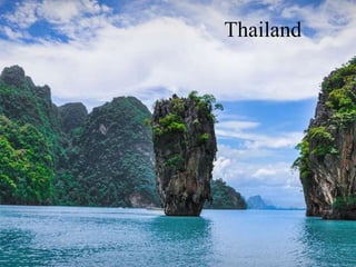
  • 20. Rock formation of Southern Bay Limestone in the bay is a mono-mineralic (one mineral) rock consisting of a single mineral (calcite) which can make up 95% of the rock. Other rocks found in marine limestone include dolomite, siderite, quartz, feldspar, mica, and various clay materials. Fragments from the hard parts of marine animals and plants, the parts which contain calcium, form the sediment. Water sets in pools on top of the islands. It percolates down through cracks in the rocks. It dissolves limestone as it goes, thus enlarging the cracks. The sides of this "sink hole" erode and dissolve. If a sea cave happens to connect with this hole, the enlarging process is sped up by the action of the sea water.
  • 21. Recent History of Natural Disaster Floods – May 2017 High amounts of Rain caused floods and flash floods in the northern provinces of Thailand Floods- December 2016 The southern provinces of Surat Thani,Nakhon Si Thammarat Songkhla, Phattalung,Pattani, Chumphon, Krabi, Trang, Yala andNarathiwat were struck by floods Fires- May 2016 Fires spread in the forested areas of Chiang Mai, Mae Hong Son, Tak and Nan provinces. Floods - October 2016 Floods that hit Nakhon Sawan province killed three people and inundated large areas of farmland as well as almost 30,000 homes. Drought – February 2016 The Government of Thailand reported that 28 provinces in Thailand were at risk of water shortages Drought - July 2015 Thailand experienced one of the worst droughts in decades, with water rationing imposed in almost a third of the country Landslides - July 2014 After three days of heavy rain, Chiang Rai province was struck by flash floods and landslides Typhoon – July 2014 Typhoon Rammasun caused torrential rainfall in Northeastern Thailand, with Yasothon province being the most affected Earthquake - May 2014 On May 5, a 6.3 on the Richter scale earthquake, with its epicenter 27km southwest of Chiang Rai, struck Thailand Floods - October 2013 From July to October northern Thailand experienced sporadic floods. Floods of 2011 Flooding was triggered by heavy monsoon rains in July 2011 and provinces were affected over a three-month period (July- September).
  • 22. Bibliography Physical envoirnment of Thailand. (2014). Retrieved August 20, 2019, from Land Development Department: https://www.ldd.go.th/ldd_en/en-US/physiographic-regions/ Assistance, C. f. (2018). Thailand Disaster Management Reference Handbook . Hickam, Hawaii: Center for Excellence in Disaster Management and Humanitairan Assistance. Keyes, J. A. (2019, August 18). Thailand. Retrieved August 20, 2019, from Encyclopaedia Britannica: https://www.britannica.com/place/Thailand Thailand. (n.d.). Retrieved August 14, 2019, from UN: http://data.un.org/en/iso/th.html