Download to read offline


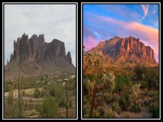
![The mountain, located near Apache Junction and Gold
Canyon, Arizona, is easily accessible from U.S. Route 60
and State Route 88. It is a popular three season (fall,
winter, spring) hiking area. Afternoon temperatures from
June to September are usually in the range of 100 to
115°F near the mountain. Day hikers often frequent the
mountain during cooler months. The Lost Dutchman State
Park is located on the western side of the mountain and
includes hiking trails to notable formations such as the
Praying Hands and the Flatiron.[4] The Peralta Trail, on the
southern side of the mountain, traverses Fremont Saddle
and descends into the wilderness to the east of the
mountain.](https://image.slidesharecdn.com/supertitionmountain-191022133632/85/Supertition-mountain-3-320.jpg)

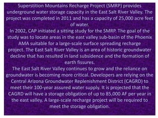


The document summarizes information about Superstition Mountain located in Arizona. It discusses the geological formation of the mountain approximately 25 million years ago from volcanic activity. It is a popular hiking destination close to Phoenix. The document also mentions legends surrounding the mountain, including the Lost Dutchman's Gold Mine that was supposedly discovered but never found. Additionally, it provides details about the Superstition Mountains Recharge Project, a water storage project completed in 2011 with the capacity to store 25,000 acre-feet of water underground in the East Salt River Valley near Phoenix.