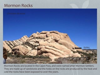
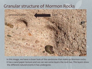
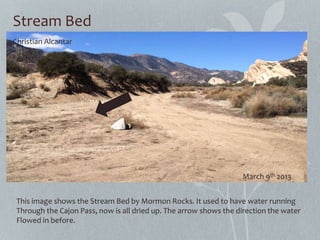
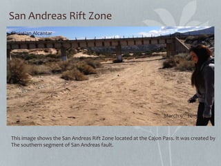
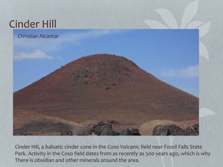
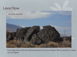
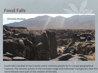
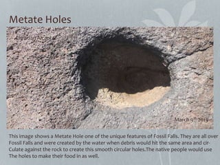
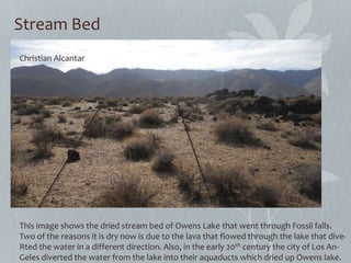
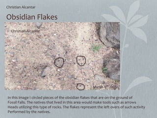
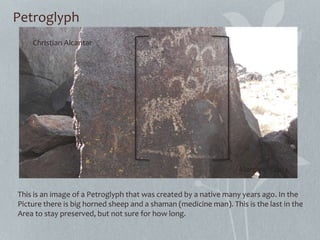
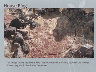
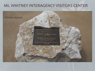
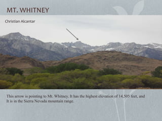
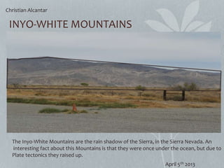
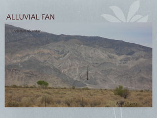
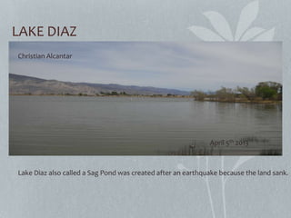
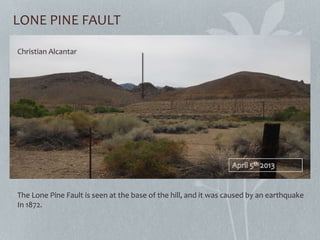
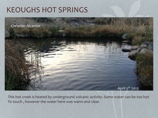
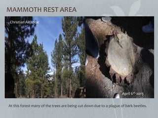
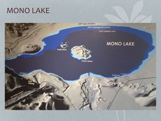
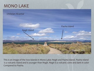
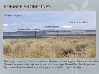
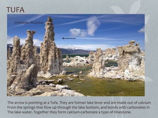
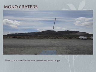
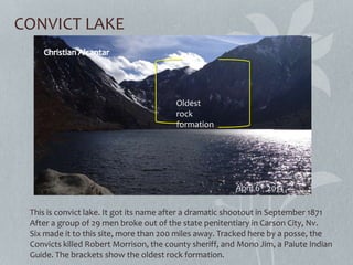
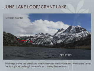
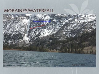
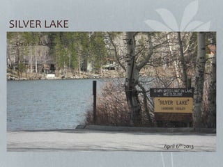
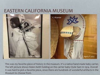
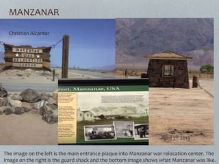
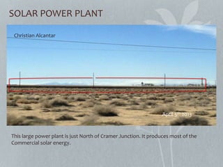
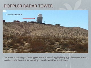
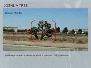
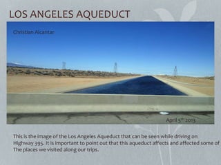
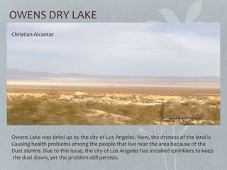
Geography 5
Christian Alcantar
April 29th 2013
FIELD JOURNAL
Field Trip One Field Trip two
• Mormon Rocks
• Cinder Hill
• Fossil Falls
• Mt. Whitney Interagency
Visitors Center
• Diaz Lake
• Manzanar
• Mammoth Area
• Mono Lake
• Panum Crater
• Convict Lake
• Keoughs Hot Springs
• June Lake Loop
• Eastern California Museum
In Transit
• Solar Power Plant
• Playa
• Doppler Radar Tower
• Garlock Fault
• Joshua tree, creosote, and Burroweed grass
• California Aquaduct/Los Angeles Aquaduct
• Owens Dry Lake
FIELD TRIP
ONE
Mormon Rocks
Mormon Rocks are located in the Cajon Pass, and were named after Mormon Settlers.
They are made up of sandstone and the holes on the rocks are produced by the heat and
cold the rocks have been exposed to over the years.
Holes
Christian Alcantar
March 9th 2013
Granular structure of Mormon Rocks
In this image, we have a closer look of the sandstone that make up Mormon rocks.
It has a sand paper texture and we can see some layers the rock has. This layers show
the different natural events it has undergone.
LayerChristian Alcantar
March 9th 2013
Stream Bed
This image shows the Stream Bed by Mormon Rocks. It used to have water running
Through the Cajon Pass, now is all dried up. The arrow shows the direction the water
Flowed in before.
Christian Alcantar
March 9th 2013
San Andreas Rift Zone
This image shows the San Andreas Rift Zone located at the Cajon Pass. It was created by
The southern segment of San Andreas fault.
Christian Alcantar
March 9th 2013
Cinder Hill
Cinder Hill, a balsatic cinder cone in the Coso Volcanic field near Fossil Falls State
Park. Activity in the Coso field dates from as recently as 500 years ago, which is why
There is obsidian and other minerals around the area.
Christian Alcantar
March 9th 2013
Lava Flow
Christian Alcantar
March 9th 2013
This image shows the lava that hardened in the Coso volcanic field. Lava flow is made
out of magma.
Fossil Falls
Fossil Falls is located in Inyo County and is visited by people for its unique geographical
Features. The volcanic activity in the mountain range and meltwater from glaciers near the
Sierra Nevada were part of the creation of the falls.
Christian Alcantar
March 9th 2013
Metate Holes
This image shows a Metate Hole one of the unique features of Fossil Falls. They are all over
Fossil Falls and were created by the water when debris would hit the same area and cir-
Culate against the rock to create this smooth circular holes.The native people would use
The holes to make their food in as well.
Christian Alcantar
March 9th 2013
Stream Bed
This image shows the dried stream bed of Owens Lake that went through Fossil falls.
Two of the reasons it is dry now is due to the lava that flowed through the lake that dive-
Rted the water in a different direction. Also, in the early 20th century the city of Los An-
Geles diverted the water from the lake into their aquaducts which dried up Owens lake.
Christian Alcantar
March 9th 2013
Obsidian Flakes
In this image I circled pieces of the obsidian flakes that are on the ground of
Fossil Falls. The natives that lived in this area would make tools such as arrows
Heads utilizing this type of rocks. The flakes represent the left overs of such activity
Performed by the natives.
Christian Alcantar
Christian Alcantar
March 9th 2013
Petroglyph
This is an image of a Petroglyph that was created by a native many years ago. In the
Picture there is big horned sheep and a shaman (medicine man). This is the last in the
Area to stay preserved, but not sure for how long.
Christian Alcantar
March 9th 2013
House Ring
This image shows the House Ring. The rock outlines the living space of the natives
Where they would live during the winter.
Christian Alcantar
March 9th 2013
FIELD TRIP
TWO
Mt. WHITNEY INTERAGENCY VISITORS CENTER
Christian Alcantar
April 5th 2013
MT. WHITNEY
This arrow is pointing to Mt. Whitney. It has the highest elevation of 14,505 feet, and
It is in the Sierra Nevada mountain range.
April 5th 2013
Christian Alcantar
INYO-WHITE MOUNTAINS
The Inyo-White Mountains are the rain shadow of the Sierra, in the Sierra Nevada. An
interesting fact about this Mountains is that they were once under the ocean, but due to
Plate tectonics they raised up.
Christian Alcantar
April 5th 2013
ALLUVIAL FAN
Christian Alcantar
April 5th 2013
LAKE DIAZ
Lake Diaz also called a Sag Pond was created after an earthquake because the land sank.
Christian Alcantar
April 5th 2013
LONE PINE FAULT
The Lone Pine Fault is seen at the base of the hill, and it was caused by an earthquake
In 1872.
Christian Alcantar
KEOUGHS HOT SPRINGS
This hot creek is heated by underground volcanic activity. Some water can be too hot
To touch , however the water here was warm and clear.
Christian Alcantar
April 5th 2013
MAMMOTH REST AREA
At this forest many of the trees are being cut down due to a plague of bark beetles.
Christian Alcantar
April 6th 2013
MONO LAKE
MONO LAKE
Christian Alcantar
April 6th 2013
Paoha Island
Negit Island
This is an image of the two islands in Mono Lake: Negit and Paoha Island. Paoha Island
is a volcanic island and is younger than Negit. Negit is a volcanic cone and dark in color
Compared to Paoha.
FORMER SHORELINES
Ancient shoreline
Old shoreline
Present day shoreline
This image shows the different shorelines Lake Mono has undergone. The ancient shoreline
Shows how massive the Lake was thousands of years ago. The old shoreline shows how
Big it was before the divertion, and the present shoreline is how it is today.
Christian Alcantar
April 6th 2013
TUFA
The arrow is pointing at a Tufa. They are former lake lever and are made out of calcium
From the springs that flow up through the lake bottom, and bonds with carbonates in
The lake water. Together they form calcium-carbonate a type of limestone.
Christian Alcantar
April 6th 2013
MONO CRATERS
Mono craters are N.America’s newest mountain range.
CONVICT LAKE
This is convict lake. It got its name after a dramatic shootout in September 1871
After a group of 29 men broke out of the state penitentiary in Carson City, Nv.
Six made it to this site, more than 200 miles away. Tracked here by a posse, the
Convicts killed Robert Morrison, the county sheriff, and Mono Jim, a Paiute Indian
Guide. The brackets show the oldest rock formation.
April 6th 2013
Oldest
rock
formation
JUNE LAKE LOOP/ GRANT LAKE
Christian Alcantar
April 6th 2013
Lateral and Terminal moraines
This image shows the lateral and terminal morains in the mountains, which were carved
Out by a glacier pushing it outward thus creating the moraines.
MORAINES/WATERFALL
Frozen Waterfall
Christian Alcantar
April 6th 2013
SILVER LAKE
Christian Alcantar
April 6th 2013
EASTERN CALIFORNIA MUSEUM
C. Alcantar
April 7th 2013
C. Alcantar
April 7th 2013
This was my favorite piece of history in the museum. It’s a native hand-made baby carrier.
The left picture shows Helen Keith holding on the carrier baby Clyde Sam In 1914. Overall
It was hard to pick a favorite piece, since there are hundreds of wonderful artifacts in the
Museum to choose from.
MANZANAR
The image on the left is the main entrance plaque into Manzanar war relocation center. The
Image on the right is the guard shack and the bottom image shows what Manzanar was like.
Christian Alcantar
April 7th 2013
IN TRANSIT
SOLAR POWER PLANT
This large power plant is just North of Cramer Junction. It produces most of the
Commercial solar energy.
Christian Alcantar
April 5th 2013
DOPPLER RADAR TOWER
The arrow is pointing at the Doppler Radar Tower along highway 395. The tower is used
to collect data from the surroundings to make weather predictions.
Christian Alcantar
April 5th 2013
JOSHUA TREE
This image shows a Joshua tree which is native of California Dessert
Christian Alcantar
April 5th 2013
LOS ANGELES AQUEDUCT
This is the image of the Los Angeles Aqueduct that can be seen while driving on
Highway 395. It is important to point out that this aqueduct affects and affected some of
The places we visited along our trips.
Christian Alcantar
April 5th 2013
OWENS DRY LAKE
Owens Lake was dried up by the city of Los Angeles. Now, the dryness of the land is
Causing health problems among the people that live near the area because of the
Dust storms. Due to this issue, the city of Los Angeles has installed sprinklers to keep
the dust down, yet the problem still persists.
Christian Alcantar
April 5th 2013

Fieldtrip1

  • 1.
    Geography 5 Christian Alcantar April29th 2013 FIELD JOURNAL
  • 2.
    Field Trip OneField Trip two • Mormon Rocks • Cinder Hill • Fossil Falls • Mt. Whitney Interagency Visitors Center • Diaz Lake • Manzanar • Mammoth Area • Mono Lake • Panum Crater • Convict Lake • Keoughs Hot Springs • June Lake Loop • Eastern California Museum
  • 3.
    In Transit • SolarPower Plant • Playa • Doppler Radar Tower • Garlock Fault • Joshua tree, creosote, and Burroweed grass • California Aquaduct/Los Angeles Aquaduct • Owens Dry Lake
  • 4.
  • 5.
    Mormon Rocks Mormon Rocksare located in the Cajon Pass, and were named after Mormon Settlers. They are made up of sandstone and the holes on the rocks are produced by the heat and cold the rocks have been exposed to over the years. Holes Christian Alcantar March 9th 2013
  • 6.
    Granular structure ofMormon Rocks In this image, we have a closer look of the sandstone that make up Mormon rocks. It has a sand paper texture and we can see some layers the rock has. This layers show the different natural events it has undergone. LayerChristian Alcantar March 9th 2013
  • 7.
    Stream Bed This imageshows the Stream Bed by Mormon Rocks. It used to have water running Through the Cajon Pass, now is all dried up. The arrow shows the direction the water Flowed in before. Christian Alcantar March 9th 2013
  • 8.
    San Andreas RiftZone This image shows the San Andreas Rift Zone located at the Cajon Pass. It was created by The southern segment of San Andreas fault. Christian Alcantar March 9th 2013
  • 9.
    Cinder Hill Cinder Hill,a balsatic cinder cone in the Coso Volcanic field near Fossil Falls State Park. Activity in the Coso field dates from as recently as 500 years ago, which is why There is obsidian and other minerals around the area. Christian Alcantar March 9th 2013
  • 10.
    Lava Flow Christian Alcantar March9th 2013 This image shows the lava that hardened in the Coso volcanic field. Lava flow is made out of magma.
  • 11.
    Fossil Falls Fossil Fallsis located in Inyo County and is visited by people for its unique geographical Features. The volcanic activity in the mountain range and meltwater from glaciers near the Sierra Nevada were part of the creation of the falls. Christian Alcantar March 9th 2013
  • 12.
    Metate Holes This imageshows a Metate Hole one of the unique features of Fossil Falls. They are all over Fossil Falls and were created by the water when debris would hit the same area and cir- Culate against the rock to create this smooth circular holes.The native people would use The holes to make their food in as well. Christian Alcantar March 9th 2013
  • 13.
    Stream Bed This imageshows the dried stream bed of Owens Lake that went through Fossil falls. Two of the reasons it is dry now is due to the lava that flowed through the lake that dive- Rted the water in a different direction. Also, in the early 20th century the city of Los An- Geles diverted the water from the lake into their aquaducts which dried up Owens lake. Christian Alcantar March 9th 2013
  • 14.
    Obsidian Flakes In thisimage I circled pieces of the obsidian flakes that are on the ground of Fossil Falls. The natives that lived in this area would make tools such as arrows Heads utilizing this type of rocks. The flakes represent the left overs of such activity Performed by the natives. Christian Alcantar Christian Alcantar March 9th 2013
  • 15.
    Petroglyph This is animage of a Petroglyph that was created by a native many years ago. In the Picture there is big horned sheep and a shaman (medicine man). This is the last in the Area to stay preserved, but not sure for how long. Christian Alcantar March 9th 2013
  • 16.
    House Ring This imageshows the House Ring. The rock outlines the living space of the natives Where they would live during the winter. Christian Alcantar March 9th 2013
  • 17.
  • 18.
    Mt. WHITNEY INTERAGENCYVISITORS CENTER Christian Alcantar April 5th 2013
  • 19.
    MT. WHITNEY This arrowis pointing to Mt. Whitney. It has the highest elevation of 14,505 feet, and It is in the Sierra Nevada mountain range. April 5th 2013 Christian Alcantar
  • 20.
    INYO-WHITE MOUNTAINS The Inyo-WhiteMountains are the rain shadow of the Sierra, in the Sierra Nevada. An interesting fact about this Mountains is that they were once under the ocean, but due to Plate tectonics they raised up. Christian Alcantar April 5th 2013
  • 21.
  • 22.
    LAKE DIAZ Lake Diazalso called a Sag Pond was created after an earthquake because the land sank. Christian Alcantar April 5th 2013
  • 23.
    LONE PINE FAULT TheLone Pine Fault is seen at the base of the hill, and it was caused by an earthquake In 1872. Christian Alcantar
  • 24.
    KEOUGHS HOT SPRINGS Thishot creek is heated by underground volcanic activity. Some water can be too hot To touch , however the water here was warm and clear. Christian Alcantar April 5th 2013
  • 25.
    MAMMOTH REST AREA Atthis forest many of the trees are being cut down due to a plague of bark beetles. Christian Alcantar April 6th 2013
  • 26.
  • 27.
    MONO LAKE Christian Alcantar April6th 2013 Paoha Island Negit Island This is an image of the two islands in Mono Lake: Negit and Paoha Island. Paoha Island is a volcanic island and is younger than Negit. Negit is a volcanic cone and dark in color Compared to Paoha.
  • 28.
    FORMER SHORELINES Ancient shoreline Oldshoreline Present day shoreline This image shows the different shorelines Lake Mono has undergone. The ancient shoreline Shows how massive the Lake was thousands of years ago. The old shoreline shows how Big it was before the divertion, and the present shoreline is how it is today. Christian Alcantar April 6th 2013
  • 29.
    TUFA The arrow ispointing at a Tufa. They are former lake lever and are made out of calcium From the springs that flow up through the lake bottom, and bonds with carbonates in The lake water. Together they form calcium-carbonate a type of limestone. Christian Alcantar April 6th 2013
  • 30.
    MONO CRATERS Mono cratersare N.America’s newest mountain range.
  • 31.
    CONVICT LAKE This isconvict lake. It got its name after a dramatic shootout in September 1871 After a group of 29 men broke out of the state penitentiary in Carson City, Nv. Six made it to this site, more than 200 miles away. Tracked here by a posse, the Convicts killed Robert Morrison, the county sheriff, and Mono Jim, a Paiute Indian Guide. The brackets show the oldest rock formation. April 6th 2013 Oldest rock formation
  • 32.
    JUNE LAKE LOOP/GRANT LAKE Christian Alcantar April 6th 2013 Lateral and Terminal moraines This image shows the lateral and terminal morains in the mountains, which were carved Out by a glacier pushing it outward thus creating the moraines.
  • 33.
  • 34.
  • 35.
    EASTERN CALIFORNIA MUSEUM C.Alcantar April 7th 2013 C. Alcantar April 7th 2013 This was my favorite piece of history in the museum. It’s a native hand-made baby carrier. The left picture shows Helen Keith holding on the carrier baby Clyde Sam In 1914. Overall It was hard to pick a favorite piece, since there are hundreds of wonderful artifacts in the Museum to choose from.
  • 36.
    MANZANAR The image onthe left is the main entrance plaque into Manzanar war relocation center. The Image on the right is the guard shack and the bottom image shows what Manzanar was like. Christian Alcantar April 7th 2013
  • 37.
  • 38.
    SOLAR POWER PLANT Thislarge power plant is just North of Cramer Junction. It produces most of the Commercial solar energy. Christian Alcantar April 5th 2013
  • 39.
    DOPPLER RADAR TOWER Thearrow is pointing at the Doppler Radar Tower along highway 395. The tower is used to collect data from the surroundings to make weather predictions. Christian Alcantar April 5th 2013
  • 40.
    JOSHUA TREE This imageshows a Joshua tree which is native of California Dessert Christian Alcantar April 5th 2013
  • 41.
    LOS ANGELES AQUEDUCT Thisis the image of the Los Angeles Aqueduct that can be seen while driving on Highway 395. It is important to point out that this aqueduct affects and affected some of The places we visited along our trips. Christian Alcantar April 5th 2013
  • 42.
    OWENS DRY LAKE OwensLake was dried up by the city of Los Angeles. Now, the dryness of the land is Causing health problems among the people that live near the area because of the Dust storms. Due to this issue, the city of Los Angeles has installed sprinklers to keep the dust down, yet the problem still persists. Christian Alcantar April 5th 2013