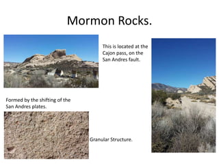
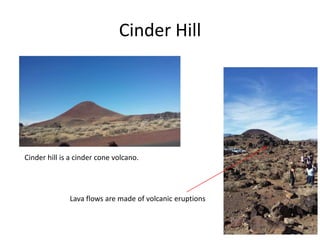
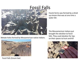
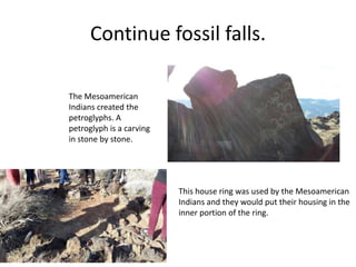
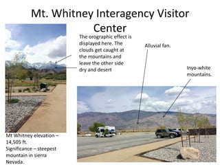
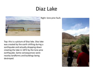
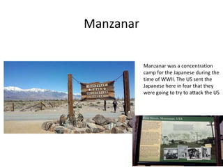
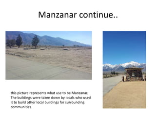
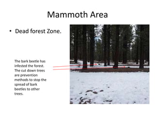
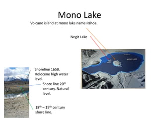
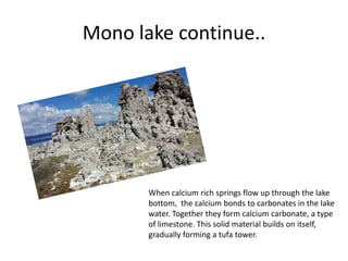
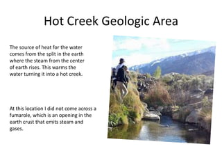
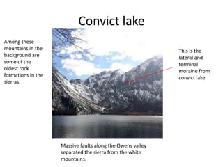
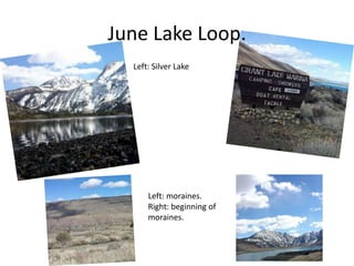
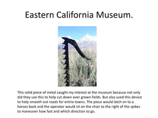
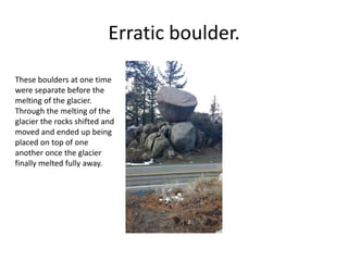
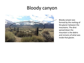
Photo Journal
Geography 5
Mrs. Schmidt.
By: Tyler Vanderwel
Mormon Rocks.
Formed by the shifting of the
San Andres plates.
Granular Structure.
This is located at the
Cajon pass, on the
San Andres fault.
Cinder Hill
Cinder hill is a cinder cone volcano.
Lava flows are made of volcanic eruptions
Fossil Falls
Fossil Falls Stream bed
Metate holes formed by Mesoamerican native Indians.
Fossils forms was formed by a dried
up stream that was at one time a
water fall.
The Mesoamerican Indians put
brought the obsidian to fossil
falls. They used obsidian for tips
on their spears to hunt and kill
Continue fossil falls.
The Mesoamerican
Indians created the
petroglyphs. A
petroglyph is a carving
in stone by stone.
This house ring was used by the Mesoamerican
Indians and they would put their housing in the
inner portion of the ring.
Mt. Whitney Interagency Visitor
Center
Mt Whitney elevation –
14,505 ft.
Significance – steepest
mountain in sierra
Nevada.
Inyo-white
mountains.
The orographic effect is
displayed here. The
clouds get caught at
the mountains and
leave the other side
dry and desert
Alluvial fan.
Diaz Lake
Top: this is a picture of Diaz lake. Diaz lake
was created by the earth shifting during a
earthquake and actually dropping down
creating the lake in 1872 by the lone pine
earthquake. Some consequences were
nearby landforms and buildings being
destroyed.
Right: lone pine fault.
Manzanar
Manzanar was a concentration
camp for the Japanese during the
time of WWII. The US sent the
Japanese here in fear that they
were going to try to attack the US
Manzanar continue..
this picture represents what use to be Manzanar.
The buildings were taken down by locals who used
it to build other local buildings for surrounding
communities.
Mammoth Area
• Dead forest Zone.
The bark beetle has
infested the forest.
The cut down trees
are prevention
methods to stop the
spread of bark
beetles to other
trees.
Mono Lake
Volcano island at mono lake name Pahoa.
Negit Lake
Shoreline 1650.
Holocene high water
level.
Shore line 20th
century. Natural
level.
18th – 19th century
shore line.
Mono lake continue..
When calcium rich springs flow up through the lake
bottom, the calcium bonds to carbonates in the lake
water. Together they form calcium carbonate, a type
of limestone. This solid material builds on itself,
gradually forming a tufa tower.
Hot Creek Geologic Area
The source of heat for the water
comes from the split in the earth
where the steam from the center
of earth rises. This warms the
water turning it into a hot creek.
At this location I did not come across a
fumarole, which is an opening in the
earth crust that emits steam and
gases.
Convict lake
Massive faults along the Owens valley
separated the sierra from the white
mountains.
This is the
lateral and
terminal
moraine from
convict lake.
Among these
mountains in the
background are
some of the
oldest rock
formations in the
sierras.
June Lake Loop.
Left: moraines.
Right: beginning of
moraines.
Left: Silver Lake
Eastern California Museum.
This solid piece of metal caught my interest at the museum because not only
did they use this to help cut down over grown fields. But also used this device
to help smooth out roads for entire towns. The piece would latch on to a
horses back and the operator would sit on the chair to the right of the spikes
to maneuver how fast and which direction to go.
Erratic boulder.
These boulders at one time
were separate before the
melting of the glacier.
Through the melting of the
glacier the rocks shifted and
moved and ended up being
placed on top of one
another once the glacier
finally melted fully away.
Bloody canyon
Bloody canyon was
formed by the melting of
the glacier between the
mountains. The dirst
spread down the
mountain is the debris
and remains of what was
inside that glacier.

Geography class

  • 1.
    Photo Journal Geography 5 Mrs.Schmidt. By: Tyler Vanderwel
  • 2.
    Mormon Rocks. Formed bythe shifting of the San Andres plates. Granular Structure. This is located at the Cajon pass, on the San Andres fault.
  • 3.
    Cinder Hill Cinder hillis a cinder cone volcano. Lava flows are made of volcanic eruptions
  • 4.
    Fossil Falls Fossil FallsStream bed Metate holes formed by Mesoamerican native Indians. Fossils forms was formed by a dried up stream that was at one time a water fall. The Mesoamerican Indians put brought the obsidian to fossil falls. They used obsidian for tips on their spears to hunt and kill
  • 5.
    Continue fossil falls. TheMesoamerican Indians created the petroglyphs. A petroglyph is a carving in stone by stone. This house ring was used by the Mesoamerican Indians and they would put their housing in the inner portion of the ring.
  • 6.
    Mt. Whitney InteragencyVisitor Center Mt Whitney elevation – 14,505 ft. Significance – steepest mountain in sierra Nevada. Inyo-white mountains. The orographic effect is displayed here. The clouds get caught at the mountains and leave the other side dry and desert Alluvial fan.
  • 7.
    Diaz Lake Top: thisis a picture of Diaz lake. Diaz lake was created by the earth shifting during a earthquake and actually dropping down creating the lake in 1872 by the lone pine earthquake. Some consequences were nearby landforms and buildings being destroyed. Right: lone pine fault.
  • 8.
    Manzanar Manzanar was aconcentration camp for the Japanese during the time of WWII. The US sent the Japanese here in fear that they were going to try to attack the US
  • 9.
    Manzanar continue.. this picturerepresents what use to be Manzanar. The buildings were taken down by locals who used it to build other local buildings for surrounding communities.
  • 10.
    Mammoth Area • Deadforest Zone. The bark beetle has infested the forest. The cut down trees are prevention methods to stop the spread of bark beetles to other trees.
  • 11.
    Mono Lake Volcano islandat mono lake name Pahoa. Negit Lake Shoreline 1650. Holocene high water level. Shore line 20th century. Natural level. 18th – 19th century shore line.
  • 12.
    Mono lake continue.. Whencalcium rich springs flow up through the lake bottom, the calcium bonds to carbonates in the lake water. Together they form calcium carbonate, a type of limestone. This solid material builds on itself, gradually forming a tufa tower.
  • 13.
    Hot Creek GeologicArea The source of heat for the water comes from the split in the earth where the steam from the center of earth rises. This warms the water turning it into a hot creek. At this location I did not come across a fumarole, which is an opening in the earth crust that emits steam and gases.
  • 14.
    Convict lake Massive faultsalong the Owens valley separated the sierra from the white mountains. This is the lateral and terminal moraine from convict lake. Among these mountains in the background are some of the oldest rock formations in the sierras.
  • 15.
    June Lake Loop. Left:moraines. Right: beginning of moraines. Left: Silver Lake
  • 16.
    Eastern California Museum. Thissolid piece of metal caught my interest at the museum because not only did they use this to help cut down over grown fields. But also used this device to help smooth out roads for entire towns. The piece would latch on to a horses back and the operator would sit on the chair to the right of the spikes to maneuver how fast and which direction to go.
  • 17.
    Erratic boulder. These bouldersat one time were separate before the melting of the glacier. Through the melting of the glacier the rocks shifted and moved and ended up being placed on top of one another once the glacier finally melted fully away.
  • 18.
    Bloody canyon Bloody canyonwas formed by the melting of the glacier between the mountains. The dirst spread down the mountain is the debris and remains of what was inside that glacier.