SlideShare a Scribd company logo
Obtaining a Denser coverage & better Signal to
noise ratio by adding more antennas to the present
configuration of GMRT
Lalit Mohan Pradhan, IIT- Guwahati
May-July 2012
Guide: Jayaram N Chengalur, NCRA-TIFR, Pune
Introduction to coordinate system and psf:
The different co-ordinate system used in the interferometer studies are shown in the above figure. The
direction cosines along the directions are respectively. The Cartesian plane when rotated by
74°.05´ E, i.e. the longitude of antenna C-02 of the GMRT, we obtain the LOC co-ordinate system. The
vector between two antennas is known as baseline. The baseline vector in Cartesian coordinate system
has components . If Hₒ is the hour angle of the source, δₒ the declination of the source in the sky
and λ the wavelength then
ₒ ₒ
ₒ ₒ ₒ ₒ ₒ
ₒ ₒ ₒ ₒ ₒ
If there are n antennas, then we would have baselines. As the earth rotates about its axis, the source
being fixed in the sky, the baseline vector components change along the coordinate system. The
trace of during a period mapped in the sky of all the different baselines gives the coverage of the
configuration of array. The equation governing the locus of is given as follows:
ₒ
ₒ
The locus is an ellipse and changes to a circle when the declination of the source becomes 90°. The two
dimensional Fourier transformation of the coverage for the point source gives the point spread
function (psf).
Temperature and Noise:
Noise Power per bandwidth at terminals of a resistor R and temperature T is given by
Using Rayleigh Jean s Law for a black body
Noise can be reduced by increasing the post detection integration time , increasing prediction bandwidth
and by taking average of more than one observation .
Two Element Interferometer:
Let the wave received from the space be where is the propagation
vector (a tensor to be exact). While dealing with the two element interferometer certain assumptions
have been made. is treated in all calculations as a scalar. If the source is at a very far distance, then the
surface brightness is measured instead, i.e . The space in the celestial sphere is taken to be empty.
On applying uygens s principal of wave propagation, the propagation vector takes a form such that the
equation reduces as
the expectation product is defined as where is the complex conjugate of . The
product
Considering
Taking a Fourier Transformation we get .
The dirty image where is the sampling function is.
Time delay (geometric delay) introduced at the two antennas is where is the baseline
vector and is the position vector on the source. ₒ where ₒ is the phase tracking center and is
the vector from the phase tracking center to any point on the projection of the souce on celestial sphere.
The output of the correlator is cos i.e. the real part of
where is the fringe amplitude which is directly proportional to the received power.
The signal received in bandwidth from the source element is where is the
brightness/intensity and is the collecting area in the direction . Thus the total power received is
cos using ₒ
cos
ₒ
cos sin
ₒ
sin
The complex visibility of a source is basically a measure of coherence of the source and mathematically is
given by where is the normalized antenna pattern
and being the response of the beam center. On separating the real and imaginary part the visibilty
function we obtain cos cos sin sin .
Thus cos
ₒ
. The cosine term represents the phase of the fringe pattern. Using the
output of the correlator, by appropriately calliberating, the phase and amplitude of the visibility function
is obtained. Inversion of the fourier trransformation of visibility function gives the brightness
distribution. The frequency of the cosine term is directly proportional to the frequency of the signal in a
finite bandwidth . For a rectangular bandwidth of centered at ,
cos cos
Full fringe amplitude is obtained only when source is in the direction normal to the baseline such that
. Operations are much easier to perform at lower intermediate frequencies than at higher
frequencies . Thus the signals are passed through a local oscillator before reaching the correlator
. To counter the geometric delay, a compensation time delay is added to the signal. After
obtaining the visibility function the dirty image is obtained and further deconvolution and cleaning
processes results in the clean image of the subject being studied.
Procedure used:
To obtain better images, the most basic task is to sample the data at every point on the plane, i.e. to
make the plane denser. The locus traced by the curves is an ellipse
ₒ
ₒ
which becomes a circle for declination 90°. Also the horizontal axis is always longer than the vertical axis
of the ellipse for any declination as sin ₒ ₒ . Thus the circles are squeezed from
the vertical sides as the declination changes from 90 . Assuming that the change in the axis of the ellipses
are linear as the with respect to the declination angle, if the plot for declination is made denser by
filling the missing radii, it should cover most of the missing baseline paths of the ellipse for ₒ .
Approach 1:
Adding one antenna would generate 30 more baselines. Suppose an antenna is added at on the LOC
plane. Then the new baselines would have the co-ordinates where i refers to all the
30 antennas. These new baselines should be such that their magnitude, should
account for the missing radii on the plane. The essential equation for solving is
. Thus where is a column matrix. To
obtain a unique , different combination of the components of column matrix matrix are to be
added in such a manner that the sum of the two matrixes is a constant.
= [ -662.50 = [194.57 =[61.6
-309.05 97.39 74.3
0.00 0.00 74.8
343.77 -151.45 75.2
534.33 -205.97 75.6
-41.45 98.59 76.0
55.27 62.52 76.4
-223.47 196.84 76.6
-25.89 58.33 83.4
214.75 136.49 83.8
610.21 -66.07 84.2
-106.08 247.99 84.7
717.06 175.78 85.0
515.82 66.39 85.5
-2799.34 437.85 85.9
-4594.52 575.64 86.3
-7763.88 1137.86 87.2
-10137.07 1672.42 87.7
-12034.01 1801.36 88.3
-349.65 1079.16 88.8
753.95 1295.18 90.4
281.83 2191.94 90.9
-66.19 3211.84 91.6
1617.62 4313.27 93.0
1477.60 -634.17 94.0
2844.30 -1313.32 95.0
4720.08 -2418.17 96.0
6290.76 -3602.52 97.0
7047.05 -4826.09 98.0
9960.86] -6071.28] 99.0]
Approach 2:
To study the change in coverage, antennas were planned to be added in a rectangular piece of land,
roughly located slightly above the existing central patch of the GMRT which has 14 antennas.
In this method, like the previous method, the coordinates of antennas to be added were calculated, but
unlike the prior method, the distinction here is that more than one antenna is considered here to be
added and since the patch being close to the central square of GMRT, effectively the inner region of
plot i.e. the shorter baseline will be affected. Here too the coverage is studied for declination ₒ
to fill up the missing radii of the circles obtained as the loci. The x coordinate in the Cartesian coordinate
system varies from -380 to -230 and the y coordinate varies from -441 to -160. For each integral
combination of the lengths of the 15 new baselines were obtained and the radii is scanned if it falls
in the missing radii category/interval. The following code is to be run in MATLAB:
Here the code calculates the missing radii between 522.2 meters and 522.31 meters. The column matrix
contains the coordinates of the central antennas from C-00 to C-14 and W-01. The
above code when run, gives the coordinates within the rectangular patch that would fill in the
different missing radii. The coordinates obtained are then rotated by 74°.05´ about the axis to
obtain the coordinates in LOC coordinate system. The different obtained in the LOC system, are then
simulated in simdata (CASA) to see the variation of coverage.
Approach 3:
The rectangular piece of land is divided into regular grids as shown.
Here unlike the previous two methods, the is not being calculated. instead antennas are placed at
the center of each grid one at a time and visually the coverage is studied. After inspecting all the
different coverage gridwise, the best combination of grids is selected. First of all, the coordinate of
center of grid is found out using google earth. Then this is converted to the cartesian coordinate system
using the following website http://www.apsalin.com/convert-geodetic-to-cartesian.aspx . Then the origin
of the coordinate system is shifted to the antenna C-02. Then rotate the coordinate system about the
axis by 74°.05´ to obtain the coordinates in the LOC system. The in the Cartesian system changes
to in the LOC coordinate system. Since the rectangular patch is close to the central square of the
GMRT, the inner region of coverage i.e. the shorter baselines are prominently affected. Hence the
coverage is plotted only for the central 14 antennas along with the antenna W-01.
Observations:
In approach 1, varies from -12000 to 10000 approximately while varies from 60 to 100
approximately. It is impossible to get a unique value of which is obtained by adding the corresponding
matrix components of and in all possible combinations of the column matrix elements. Similarly
varies from -6000 to 4000 and hence it is impossible to obtain a unique . This method can be however
used for generating an array with lesser number of antennas for a good coverage with minimum
number of antennas at place.
In approach 2 after running all the simulations of the obtained in the LOC system a set of three
antennas was finalized.
In approach 3 the coverage of existing central antennas and W-01 along with an antenna placed at the
center of each individual grid are shown below.
Based on visual analysis a combination of grid 5, 9 &13 were found to be apt. also to be noted is that these
grids approximately are in agreement with locations of antennas found in approach 2. This analysis is
visual in nature and does not establish any numerical ground to compare.
Results:
The final configuration antennas added in the patch has the following four new antennas added based on
results of approach 2 &3 which also takes care of the shorter baselines near the origin of plot.
Clockwise from top left- declination=-30, 45, 90, 60
Another good configuration in the patch consists of 6 antennas in the patch with coordinates:
This configuration takes care of the smaller baselines in an much more efficient manner. To see the actual
variation of as we zoom into the central part paste this on the url: http://makeagif.com/i/xE4QDy
to compare it with the new antennas added paste: http://makeagif.com/i/oe0AHI

More Related Content

What's hot

Warrp sesimic_ aghazde
Warrp sesimic_ aghazdeWarrp sesimic_ aghazde
Electromagnetic radiations2
Electromagnetic  radiations2Electromagnetic  radiations2
Electromagnetic radiations2
Ashok Kamble
 
[PDF] Mauritius2017 - Testing strong-field gravity with pulsar timing & gravi...
[PDF] Mauritius2017 - Testing strong-field gravity with pulsar timing & gravi...[PDF] Mauritius2017 - Testing strong-field gravity with pulsar timing & gravi...
[PDF] Mauritius2017 - Testing strong-field gravity with pulsar timing & gravi...
Lijing Shao
 
The Dvorak Technique
The Dvorak TechniqueThe Dvorak Technique
The Dvorak Technique
Katelyn Hearn
 
Towards the identification of the primary particle nature by the radiodetecti...
Towards the identification of the primary particle nature by the radiodetecti...Towards the identification of the primary particle nature by the radiodetecti...
Towards the identification of the primary particle nature by the radiodetecti...
Ahmed Ammar Rebai PhD
 
F04523742
F04523742F04523742
F04523742
IOSR-JEN
 
Neutron Star Powered Nebulae
Neutron Star Powered NebulaeNeutron Star Powered Nebulae
Neutron Star Powered Nebulae
joshualande
 
Seismic velocity analysis _ aghazade
Seismic velocity analysis _ aghazadeSeismic velocity analysis _ aghazade
Seismic velocity analysis _ aghazade
Inistute of Geophysics, Tehran university , Tehran/ iran
 
Future ground arrays for ultrahigh-energy cosmic rays: recent updates and per...
Future ground arrays for ultrahigh-energy cosmic rays: recent updates and per...Future ground arrays for ultrahigh-energy cosmic rays: recent updates and per...
Future ground arrays for ultrahigh-energy cosmic rays: recent updates and per...
Toshihiro FUJII
 
Probing the Detailed Physics of Hot Baryons with Lynx: Predictions from Mock ...
Probing the Detailed Physics of Hot Baryons with Lynx: Predictions from Mock ...Probing the Detailed Physics of Hot Baryons with Lynx: Predictions from Mock ...
Probing the Detailed Physics of Hot Baryons with Lynx: Predictions from Mock ...
John ZuHone
 
UPLINK, DOWNLINK AND OVERALL LINK PERFORMANCE INTER-SATELLITE LINKS
UPLINK, DOWNLINK ANDOVERALL LINK PERFORMANCE INTER-SATELLITE LINKSUPLINK, DOWNLINK ANDOVERALL LINK PERFORMANCE INTER-SATELLITE LINKS
UPLINK, DOWNLINK AND OVERALL LINK PERFORMANCE INTER-SATELLITE LINKS
Ahmed Ayman
 
Raqrs06 Borel Talk 8 15 06 White
Raqrs06 Borel Talk 8 15 06 WhiteRaqrs06 Borel Talk 8 15 06 White
Raqrs06 Borel Talk 8 15 06 Whiteguest0030172
 
A gravitational-wave standard siren measurement of the Hubble constant
A gravitational-wave standard siren measurement of the Hubble constantA gravitational-wave standard siren measurement of the Hubble constant
A gravitational-wave standard siren measurement of the Hubble constant
Sérgio Sacani
 
WE3.L09 - RAIN EFFECT ON POLARIMETRIC SAR OBSERVATION
WE3.L09 - RAIN EFFECT ON POLARIMETRIC SAR OBSERVATIONWE3.L09 - RAIN EFFECT ON POLARIMETRIC SAR OBSERVATION
WE3.L09 - RAIN EFFECT ON POLARIMETRIC SAR OBSERVATIONgrssieee
 
The bright optical_flash_and_afterglow_from_the_gamma_ray_burst_grb_130427a
The bright optical_flash_and_afterglow_from_the_gamma_ray_burst_grb_130427aThe bright optical_flash_and_afterglow_from_the_gamma_ray_burst_grb_130427a
The bright optical_flash_and_afterglow_from_the_gamma_ray_burst_grb_130427aSérgio Sacani
 
Ms 1341-p touze-final
Ms 1341-p touze-finalMs 1341-p touze-final
Ms 1341-p touze-final
ThomasTouz
 

What's hot (20)

Sheet # 1
Sheet # 1Sheet # 1
Sheet # 1
 
Warrp sesimic_ aghazde
Warrp sesimic_ aghazdeWarrp sesimic_ aghazde
Warrp sesimic_ aghazde
 
Electromagnetic radiations2
Electromagnetic  radiations2Electromagnetic  radiations2
Electromagnetic radiations2
 
[PDF] Mauritius2017 - Testing strong-field gravity with pulsar timing & gravi...
[PDF] Mauritius2017 - Testing strong-field gravity with pulsar timing & gravi...[PDF] Mauritius2017 - Testing strong-field gravity with pulsar timing & gravi...
[PDF] Mauritius2017 - Testing strong-field gravity with pulsar timing & gravi...
 
The Dvorak Technique
The Dvorak TechniqueThe Dvorak Technique
The Dvorak Technique
 
Towards the identification of the primary particle nature by the radiodetecti...
Towards the identification of the primary particle nature by the radiodetecti...Towards the identification of the primary particle nature by the radiodetecti...
Towards the identification of the primary particle nature by the radiodetecti...
 
F04523742
F04523742F04523742
F04523742
 
Neutron Star Powered Nebulae
Neutron Star Powered NebulaeNeutron Star Powered Nebulae
Neutron Star Powered Nebulae
 
Seismic velocity analysis _ aghazade
Seismic velocity analysis _ aghazadeSeismic velocity analysis _ aghazade
Seismic velocity analysis _ aghazade
 
Future ground arrays for ultrahigh-energy cosmic rays: recent updates and per...
Future ground arrays for ultrahigh-energy cosmic rays: recent updates and per...Future ground arrays for ultrahigh-energy cosmic rays: recent updates and per...
Future ground arrays for ultrahigh-energy cosmic rays: recent updates and per...
 
Probing the Detailed Physics of Hot Baryons with Lynx: Predictions from Mock ...
Probing the Detailed Physics of Hot Baryons with Lynx: Predictions from Mock ...Probing the Detailed Physics of Hot Baryons with Lynx: Predictions from Mock ...
Probing the Detailed Physics of Hot Baryons with Lynx: Predictions from Mock ...
 
Automation Controller
Automation ControllerAutomation Controller
Automation Controller
 
UPLINK, DOWNLINK AND OVERALL LINK PERFORMANCE INTER-SATELLITE LINKS
UPLINK, DOWNLINK ANDOVERALL LINK PERFORMANCE INTER-SATELLITE LINKSUPLINK, DOWNLINK ANDOVERALL LINK PERFORMANCE INTER-SATELLITE LINKS
UPLINK, DOWNLINK AND OVERALL LINK PERFORMANCE INTER-SATELLITE LINKS
 
Raqrs06 Borel Talk 8 15 06 White
Raqrs06 Borel Talk 8 15 06 WhiteRaqrs06 Borel Talk 8 15 06 White
Raqrs06 Borel Talk 8 15 06 White
 
A gravitational-wave standard siren measurement of the Hubble constant
A gravitational-wave standard siren measurement of the Hubble constantA gravitational-wave standard siren measurement of the Hubble constant
A gravitational-wave standard siren measurement of the Hubble constant
 
Basics on Radar Cross Section
Basics on Radar Cross SectionBasics on Radar Cross Section
Basics on Radar Cross Section
 
WE3.L09 - RAIN EFFECT ON POLARIMETRIC SAR OBSERVATION
WE3.L09 - RAIN EFFECT ON POLARIMETRIC SAR OBSERVATIONWE3.L09 - RAIN EFFECT ON POLARIMETRIC SAR OBSERVATION
WE3.L09 - RAIN EFFECT ON POLARIMETRIC SAR OBSERVATION
 
EPD_R&D_Proposal
EPD_R&D_ProposalEPD_R&D_Proposal
EPD_R&D_Proposal
 
The bright optical_flash_and_afterglow_from_the_gamma_ray_burst_grb_130427a
The bright optical_flash_and_afterglow_from_the_gamma_ray_burst_grb_130427aThe bright optical_flash_and_afterglow_from_the_gamma_ray_burst_grb_130427a
The bright optical_flash_and_afterglow_from_the_gamma_ray_burst_grb_130427a
 
Ms 1341-p touze-final
Ms 1341-p touze-finalMs 1341-p touze-final
Ms 1341-p touze-final
 

Viewers also liked

Formación profesorado Asturias
Formación profesorado AsturiasFormación profesorado Asturias
Formación profesorado Asturias
samanthabl25
 
Ms วิธีติดตั้ง ea
Ms วิธีติดตั้ง eaMs วิธีติดตั้ง ea
Ms วิธีติดตั้ง ea
tato octopus
 
Presentacion asamblea kiowa s. santa 2016
Presentacion asamblea kiowa s. santa 2016Presentacion asamblea kiowa s. santa 2016
Presentacion asamblea kiowa s. santa 2016
kiowa217
 
Pandora neira herrera tarea 2
Pandora neira herrera tarea 2Pandora neira herrera tarea 2
Pandora neira herrera tarea 2
Neira Herrera
 
Act 1 unidad 2 uzv
Act 1 unidad 2 uzvAct 1 unidad 2 uzv
Act 1 unidad 2 uzv
Uriel Zermeño Vera
 
Top 160 citations célèbres et inspirantes pour entrepreneurs et auto entrepre...
Top 160 citations célèbres et inspirantes pour entrepreneurs et auto entrepre...Top 160 citations célèbres et inspirantes pour entrepreneurs et auto entrepre...
Top 160 citations célèbres et inspirantes pour entrepreneurs et auto entrepre...
TeddyNM
 
Web Mobile : quelles opportunités face aux apps ?
Web Mobile : quelles opportunités face aux apps ?Web Mobile : quelles opportunités face aux apps ?
Web Mobile : quelles opportunités face aux apps ?
NiceToMeetYou
 
Web { Design Project } Management
Web { Design Project } ManagementWeb { Design Project } Management
Web { Design Project } Management
David Roessli
 
Le web : un monde virtuel en plein essor
Le web : un monde virtuel en plein essorLe web : un monde virtuel en plein essor
Le web : un monde virtuel en plein essor
marinemaingot
 
Tarea 1 fatla polaris
Tarea 1 fatla polarisTarea 1 fatla polaris
Tarea 1 fatla polaris
Neira Herrera
 

Viewers also liked (13)

Aquacy
Aquacy Aquacy
Aquacy
 
Formación profesorado Asturias
Formación profesorado AsturiasFormación profesorado Asturias
Formación profesorado Asturias
 
BTP First Phase
BTP First PhaseBTP First Phase
BTP First Phase
 
Ms วิธีติดตั้ง ea
Ms วิธีติดตั้ง eaMs วิธีติดตั้ง ea
Ms วิธีติดตั้ง ea
 
Presentacion asamblea kiowa s. santa 2016
Presentacion asamblea kiowa s. santa 2016Presentacion asamblea kiowa s. santa 2016
Presentacion asamblea kiowa s. santa 2016
 
Pandora neira herrera tarea 2
Pandora neira herrera tarea 2Pandora neira herrera tarea 2
Pandora neira herrera tarea 2
 
Act 1 unidad 2 uzv
Act 1 unidad 2 uzvAct 1 unidad 2 uzv
Act 1 unidad 2 uzv
 
Top 160 citations célèbres et inspirantes pour entrepreneurs et auto entrepre...
Top 160 citations célèbres et inspirantes pour entrepreneurs et auto entrepre...Top 160 citations célèbres et inspirantes pour entrepreneurs et auto entrepre...
Top 160 citations célèbres et inspirantes pour entrepreneurs et auto entrepre...
 
Web Mobile : quelles opportunités face aux apps ?
Web Mobile : quelles opportunités face aux apps ?Web Mobile : quelles opportunités face aux apps ?
Web Mobile : quelles opportunités face aux apps ?
 
Web { Design Project } Management
Web { Design Project } ManagementWeb { Design Project } Management
Web { Design Project } Management
 
Véhicules électriques
Véhicules électriquesVéhicules électriques
Véhicules électriques
 
Le web : un monde virtuel en plein essor
Le web : un monde virtuel en plein essorLe web : un monde virtuel en plein essor
Le web : un monde virtuel en plein essor
 
Tarea 1 fatla polaris
Tarea 1 fatla polarisTarea 1 fatla polaris
Tarea 1 fatla polaris
 

Similar to Summer 2012 Project Report

Book 3: “Antennae Techniques”
Book 3: “Antennae Techniques”Book 3: “Antennae Techniques”
Book 3: “Antennae Techniques”
Timour Chaikhraziev
 
False Peaks Occuring at Direction-Finding Via Cylindrical Antenna Array with ...
False Peaks Occuring at Direction-Finding Via Cylindrical Antenna Array with ...False Peaks Occuring at Direction-Finding Via Cylindrical Antenna Array with ...
False Peaks Occuring at Direction-Finding Via Cylindrical Antenna Array with ...
IJRESJOURNAL
 
What is the radiation pattern?
What is the radiation pattern?What is the radiation pattern?
What is the radiation pattern?
Antenna Manufacturer Coco
 
Modeling Beam forming in Circular Antenna Array with Directional Emitters
Modeling Beam forming in Circular Antenna Array with Directional EmittersModeling Beam forming in Circular Antenna Array with Directional Emitters
Modeling Beam forming in Circular Antenna Array with Directional Emitters
IJRESJOURNAL
 
Reflector Antennas Design and mathematical expression_1.pptx
Reflector Antennas Design and mathematical expression_1.pptxReflector Antennas Design and mathematical expression_1.pptx
Reflector Antennas Design and mathematical expression_1.pptx
jaychoudhary37
 
control engineering revision
control engineering revisioncontrol engineering revision
control engineering revision
ragu nath
 
Three Element Beam forming Algorithm with Reduced Interference Effect in Sign...
Three Element Beam forming Algorithm with Reduced Interference Effect in Sign...Three Element Beam forming Algorithm with Reduced Interference Effect in Sign...
Three Element Beam forming Algorithm with Reduced Interference Effect in Sign...
IJMER
 
Sensor Localization presentation1&2
Sensor Localization  presentation1&2Sensor Localization  presentation1&2
Sensor Localization presentation1&2
gamalsallam1989
 
An absorption profile centred at 78 megahertz in the sky-averaged spectrum
An absorption profile centred at 78 megahertz in the sky-averaged spectrumAn absorption profile centred at 78 megahertz in the sky-averaged spectrum
An absorption profile centred at 78 megahertz in the sky-averaged spectrum
Sérgio Sacani
 
Reduction of Azimuth Uncertainties in SAR Images Using Selective Restoration
Reduction of Azimuth Uncertainties in SAR Images Using Selective RestorationReduction of Azimuth Uncertainties in SAR Images Using Selective Restoration
Reduction of Azimuth Uncertainties in SAR Images Using Selective Restoration
IJTET Journal
 
MULTI-ANTENNA LOCALIZATION METHOD
MULTI-ANTENNA LOCALIZATION METHODMULTI-ANTENNA LOCALIZATION METHOD
MULTI-ANTENNA LOCALIZATION METHOD
ijwmn
 
Elements Space and Amplitude Perturbation Using Genetic Algorithm for Antenna...
Elements Space and Amplitude Perturbation Using Genetic Algorithm for Antenna...Elements Space and Amplitude Perturbation Using Genetic Algorithm for Antenna...
Elements Space and Amplitude Perturbation Using Genetic Algorithm for Antenna...
CSCJournals
 
Towards the identification of the primary particle nature by the radiodetecti...
Towards the identification of the primary particle nature by the radiodetecti...Towards the identification of the primary particle nature by the radiodetecti...
Towards the identification of the primary particle nature by the radiodetecti...
Ahmed Ammar Rebai PhD
 
Synthetic aperture radar
Synthetic aperture radarSynthetic aperture radar
Synthetic aperture radar
Mahesh pawar
 
Mri artifacts
Mri artifactsMri artifacts
Mri artifacts
shaker nawasrah
 

Similar to Summer 2012 Project Report (20)

Book 3: “Antennae Techniques”
Book 3: “Antennae Techniques”Book 3: “Antennae Techniques”
Book 3: “Antennae Techniques”
 
False Peaks Occuring at Direction-Finding Via Cylindrical Antenna Array with ...
False Peaks Occuring at Direction-Finding Via Cylindrical Antenna Array with ...False Peaks Occuring at Direction-Finding Via Cylindrical Antenna Array with ...
False Peaks Occuring at Direction-Finding Via Cylindrical Antenna Array with ...
 
TRS
TRSTRS
TRS
 
What is the radiation pattern?
What is the radiation pattern?What is the radiation pattern?
What is the radiation pattern?
 
Modeling Beam forming in Circular Antenna Array with Directional Emitters
Modeling Beam forming in Circular Antenna Array with Directional EmittersModeling Beam forming in Circular Antenna Array with Directional Emitters
Modeling Beam forming in Circular Antenna Array with Directional Emitters
 
Ag4301181184
Ag4301181184Ag4301181184
Ag4301181184
 
Reflector Antennas Design and mathematical expression_1.pptx
Reflector Antennas Design and mathematical expression_1.pptxReflector Antennas Design and mathematical expression_1.pptx
Reflector Antennas Design and mathematical expression_1.pptx
 
control engineering revision
control engineering revisioncontrol engineering revision
control engineering revision
 
Three Element Beam forming Algorithm with Reduced Interference Effect in Sign...
Three Element Beam forming Algorithm with Reduced Interference Effect in Sign...Three Element Beam forming Algorithm with Reduced Interference Effect in Sign...
Three Element Beam forming Algorithm with Reduced Interference Effect in Sign...
 
Sensor Localization presentation1&2
Sensor Localization  presentation1&2Sensor Localization  presentation1&2
Sensor Localization presentation1&2
 
An absorption profile centred at 78 megahertz in the sky-averaged spectrum
An absorption profile centred at 78 megahertz in the sky-averaged spectrumAn absorption profile centred at 78 megahertz in the sky-averaged spectrum
An absorption profile centred at 78 megahertz in the sky-averaged spectrum
 
Reduction of Azimuth Uncertainties in SAR Images Using Selective Restoration
Reduction of Azimuth Uncertainties in SAR Images Using Selective RestorationReduction of Azimuth Uncertainties in SAR Images Using Selective Restoration
Reduction of Azimuth Uncertainties in SAR Images Using Selective Restoration
 
MULTI-ANTENNA LOCALIZATION METHOD
MULTI-ANTENNA LOCALIZATION METHODMULTI-ANTENNA LOCALIZATION METHOD
MULTI-ANTENNA LOCALIZATION METHOD
 
Elements Space and Amplitude Perturbation Using Genetic Algorithm for Antenna...
Elements Space and Amplitude Perturbation Using Genetic Algorithm for Antenna...Elements Space and Amplitude Perturbation Using Genetic Algorithm for Antenna...
Elements Space and Amplitude Perturbation Using Genetic Algorithm for Antenna...
 
Towards the identification of the primary particle nature by the radiodetecti...
Towards the identification of the primary particle nature by the radiodetecti...Towards the identification of the primary particle nature by the radiodetecti...
Towards the identification of the primary particle nature by the radiodetecti...
 
Synthetic aperture radar
Synthetic aperture radarSynthetic aperture radar
Synthetic aperture radar
 
AntennasReport
AntennasReportAntennasReport
AntennasReport
 
Ag03302030208
Ag03302030208Ag03302030208
Ag03302030208
 
Mri artifacts
Mri artifactsMri artifacts
Mri artifacts
 
Freznal zone
Freznal zoneFreznal zone
Freznal zone
 

Summer 2012 Project Report

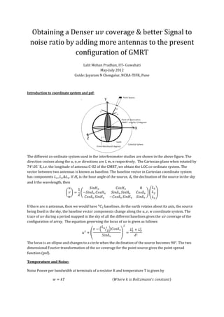
  • 1. Obtaining a Denser coverage & better Signal to noise ratio by adding more antennas to the present configuration of GMRT Lalit Mohan Pradhan, IIT- Guwahati May-July 2012 Guide: Jayaram N Chengalur, NCRA-TIFR, Pune Introduction to coordinate system and psf: The different co-ordinate system used in the interferometer studies are shown in the above figure. The direction cosines along the directions are respectively. The Cartesian plane when rotated by 74°.05´ E, i.e. the longitude of antenna C-02 of the GMRT, we obtain the LOC co-ordinate system. The vector between two antennas is known as baseline. The baseline vector in Cartesian coordinate system has components . If Hₒ is the hour angle of the source, δₒ the declination of the source in the sky and λ the wavelength then ₒ ₒ ₒ ₒ ₒ ₒ ₒ ₒ ₒ ₒ ₒ ₒ If there are n antennas, then we would have baselines. As the earth rotates about its axis, the source being fixed in the sky, the baseline vector components change along the coordinate system. The trace of during a period mapped in the sky of all the different baselines gives the coverage of the configuration of array. The equation governing the locus of is given as follows: ₒ ₒ The locus is an ellipse and changes to a circle when the declination of the source becomes 90°. The two dimensional Fourier transformation of the coverage for the point source gives the point spread function (psf). Temperature and Noise: Noise Power per bandwidth at terminals of a resistor R and temperature T is given by
  • 2. Using Rayleigh Jean s Law for a black body Noise can be reduced by increasing the post detection integration time , increasing prediction bandwidth and by taking average of more than one observation . Two Element Interferometer: Let the wave received from the space be where is the propagation vector (a tensor to be exact). While dealing with the two element interferometer certain assumptions have been made. is treated in all calculations as a scalar. If the source is at a very far distance, then the surface brightness is measured instead, i.e . The space in the celestial sphere is taken to be empty. On applying uygens s principal of wave propagation, the propagation vector takes a form such that the equation reduces as the expectation product is defined as where is the complex conjugate of . The product Considering Taking a Fourier Transformation we get .
  • 3. The dirty image where is the sampling function is. Time delay (geometric delay) introduced at the two antennas is where is the baseline vector and is the position vector on the source. ₒ where ₒ is the phase tracking center and is the vector from the phase tracking center to any point on the projection of the souce on celestial sphere. The output of the correlator is cos i.e. the real part of where is the fringe amplitude which is directly proportional to the received power. The signal received in bandwidth from the source element is where is the brightness/intensity and is the collecting area in the direction . Thus the total power received is cos using ₒ cos ₒ cos sin ₒ sin The complex visibility of a source is basically a measure of coherence of the source and mathematically is given by where is the normalized antenna pattern and being the response of the beam center. On separating the real and imaginary part the visibilty function we obtain cos cos sin sin . Thus cos ₒ . The cosine term represents the phase of the fringe pattern. Using the output of the correlator, by appropriately calliberating, the phase and amplitude of the visibility function is obtained. Inversion of the fourier trransformation of visibility function gives the brightness distribution. The frequency of the cosine term is directly proportional to the frequency of the signal in a finite bandwidth . For a rectangular bandwidth of centered at , cos cos Full fringe amplitude is obtained only when source is in the direction normal to the baseline such that . Operations are much easier to perform at lower intermediate frequencies than at higher frequencies . Thus the signals are passed through a local oscillator before reaching the correlator . To counter the geometric delay, a compensation time delay is added to the signal. After obtaining the visibility function the dirty image is obtained and further deconvolution and cleaning processes results in the clean image of the subject being studied.
  • 4. Procedure used: To obtain better images, the most basic task is to sample the data at every point on the plane, i.e. to make the plane denser. The locus traced by the curves is an ellipse ₒ ₒ which becomes a circle for declination 90°. Also the horizontal axis is always longer than the vertical axis of the ellipse for any declination as sin ₒ ₒ . Thus the circles are squeezed from the vertical sides as the declination changes from 90 . Assuming that the change in the axis of the ellipses are linear as the with respect to the declination angle, if the plot for declination is made denser by filling the missing radii, it should cover most of the missing baseline paths of the ellipse for ₒ . Approach 1: Adding one antenna would generate 30 more baselines. Suppose an antenna is added at on the LOC plane. Then the new baselines would have the co-ordinates where i refers to all the 30 antennas. These new baselines should be such that their magnitude, should account for the missing radii on the plane. The essential equation for solving is . Thus where is a column matrix. To obtain a unique , different combination of the components of column matrix matrix are to be added in such a manner that the sum of the two matrixes is a constant. = [ -662.50 = [194.57 =[61.6 -309.05 97.39 74.3 0.00 0.00 74.8 343.77 -151.45 75.2 534.33 -205.97 75.6 -41.45 98.59 76.0 55.27 62.52 76.4 -223.47 196.84 76.6 -25.89 58.33 83.4 214.75 136.49 83.8 610.21 -66.07 84.2 -106.08 247.99 84.7 717.06 175.78 85.0 515.82 66.39 85.5 -2799.34 437.85 85.9 -4594.52 575.64 86.3 -7763.88 1137.86 87.2 -10137.07 1672.42 87.7 -12034.01 1801.36 88.3 -349.65 1079.16 88.8 753.95 1295.18 90.4 281.83 2191.94 90.9 -66.19 3211.84 91.6 1617.62 4313.27 93.0 1477.60 -634.17 94.0 2844.30 -1313.32 95.0 4720.08 -2418.17 96.0 6290.76 -3602.52 97.0 7047.05 -4826.09 98.0 9960.86] -6071.28] 99.0]
  • 5. Approach 2: To study the change in coverage, antennas were planned to be added in a rectangular piece of land, roughly located slightly above the existing central patch of the GMRT which has 14 antennas. In this method, like the previous method, the coordinates of antennas to be added were calculated, but unlike the prior method, the distinction here is that more than one antenna is considered here to be added and since the patch being close to the central square of GMRT, effectively the inner region of plot i.e. the shorter baseline will be affected. Here too the coverage is studied for declination ₒ to fill up the missing radii of the circles obtained as the loci. The x coordinate in the Cartesian coordinate system varies from -380 to -230 and the y coordinate varies from -441 to -160. For each integral combination of the lengths of the 15 new baselines were obtained and the radii is scanned if it falls in the missing radii category/interval. The following code is to be run in MATLAB: Here the code calculates the missing radii between 522.2 meters and 522.31 meters. The column matrix contains the coordinates of the central antennas from C-00 to C-14 and W-01. The above code when run, gives the coordinates within the rectangular patch that would fill in the different missing radii. The coordinates obtained are then rotated by 74°.05´ about the axis to obtain the coordinates in LOC coordinate system. The different obtained in the LOC system, are then simulated in simdata (CASA) to see the variation of coverage. Approach 3: The rectangular piece of land is divided into regular grids as shown.
  • 6. Here unlike the previous two methods, the is not being calculated. instead antennas are placed at the center of each grid one at a time and visually the coverage is studied. After inspecting all the different coverage gridwise, the best combination of grids is selected. First of all, the coordinate of center of grid is found out using google earth. Then this is converted to the cartesian coordinate system using the following website http://www.apsalin.com/convert-geodetic-to-cartesian.aspx . Then the origin of the coordinate system is shifted to the antenna C-02. Then rotate the coordinate system about the axis by 74°.05´ to obtain the coordinates in the LOC system. The in the Cartesian system changes to in the LOC coordinate system. Since the rectangular patch is close to the central square of the GMRT, the inner region of coverage i.e. the shorter baselines are prominently affected. Hence the coverage is plotted only for the central 14 antennas along with the antenna W-01. Observations: In approach 1, varies from -12000 to 10000 approximately while varies from 60 to 100 approximately. It is impossible to get a unique value of which is obtained by adding the corresponding matrix components of and in all possible combinations of the column matrix elements. Similarly varies from -6000 to 4000 and hence it is impossible to obtain a unique . This method can be however used for generating an array with lesser number of antennas for a good coverage with minimum number of antennas at place. In approach 2 after running all the simulations of the obtained in the LOC system a set of three antennas was finalized.
  • 7. In approach 3 the coverage of existing central antennas and W-01 along with an antenna placed at the center of each individual grid are shown below. Based on visual analysis a combination of grid 5, 9 &13 were found to be apt. also to be noted is that these grids approximately are in agreement with locations of antennas found in approach 2. This analysis is visual in nature and does not establish any numerical ground to compare. Results: The final configuration antennas added in the patch has the following four new antennas added based on results of approach 2 &3 which also takes care of the shorter baselines near the origin of plot.
  • 8. Clockwise from top left- declination=-30, 45, 90, 60 Another good configuration in the patch consists of 6 antennas in the patch with coordinates: This configuration takes care of the smaller baselines in an much more efficient manner. To see the actual variation of as we zoom into the central part paste this on the url: http://makeagif.com/i/xE4QDy to compare it with the new antennas added paste: http://makeagif.com/i/oe0AHI