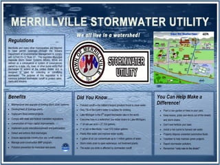
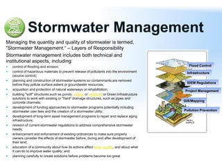
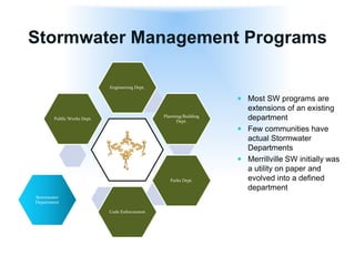
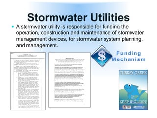
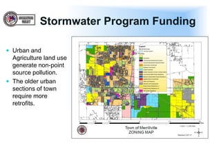
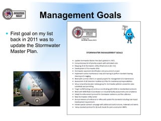
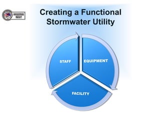
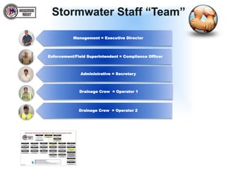
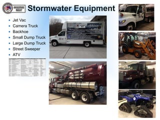
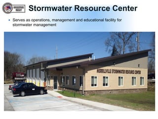
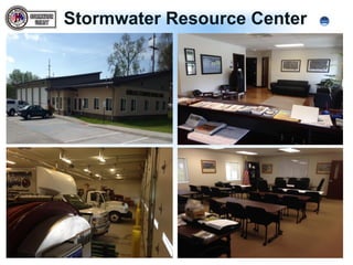
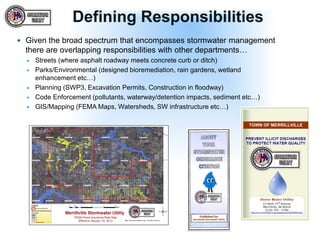
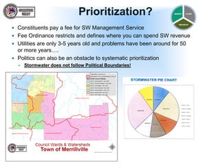
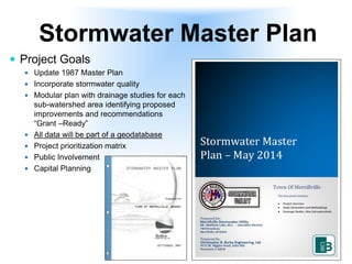
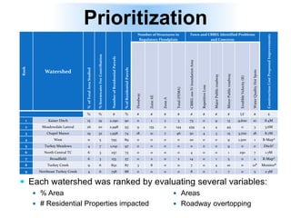
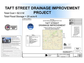
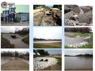
Matthew Lake, M.S., CMS4S - Executive Director
MERRILLVILLE
Utility Development & Master Plans
Stormwater Utility
Development
Stormwater Management
Managing the quantity and quality of stormwater is termed,
"Stormwater Management.“ – Layers of Responsibility
Stormwater management includes both technical and
institutional aspects, including:
 control of flooding and erosion;
 control of hazardous materials to prevent release of pollutants into the environment
(source control);
 planning and construction of stormwater systems so contaminants are removed
before they pollute surface waters or groundwater resources;
 acquisition and protection of natural waterways or rehabilitation;
 building "soft" structures such as ponds, swales or wetlands or Green Infrastructure
solutions to work with existing or "hard" drainage structures, such as pipes and
concrete channels;
 development of funding approaches to stormwater programs potentially including
stormwater user fees and the creation of a stormwater utility;
 development of long-term asset management programs to repair and replace aging
infrastructure;
 revision of current stormwater regulations to address comprehensive stormwater
needs;
 enhancement and enforcement of existing ordinances to make sure property
owners consider the effects of stormwater before, during and after development of
their land;
 education of a community about how its actions affect water quality, and about what
it can do to improve water quality; and
 planning carefully to create solutions before problems become too great
Flood Control
Infrastructure
IDEM Regulations
Project Management
GIS/Mapping
Pollution Prevention
Stormwater Management Programs
 Most SW programs are
extensions of an existing
department
 Few communities have
actual Stormwater
Departments
 Merrillville SW initially was
a utility on paper and
evolved into a defined
department
Engineering Dept.
Planning/Building
Dept.
Parks Dept.
Code Enforcement
Stormwater
Department
Public Works Dept.
Stormwater Utilities
 A stormwater utility is responsible for funding the
operation, construction and maintenance of stormwater
management devices, for stormwater system planning,
and management.
Stormwater Program Funding
 Many Indiana entities have
stormwater fees…
 Average = $4.70
 Merrillville established a
modest fee
 Ex: residential $5/month
 Based on land use
 Stormwater master
planning: making better use
of limited dollars by
targeting high priority
stormwater projects.
Stormwater Program Funding
 Urban and
Agriculture land use
generate non-point
source pollution.
 The older urban
sections of town
require more
retrofits.
Management Goals
 First goal on my list
back in 2011 was to
update the Stormwater
Master Plan.
Creating a Functional
Stormwater Utility
Stormwater Staff “Team”
Management = Executive Director
Enforcement/Field Superintendent = Compliance Officer
Administrative = Secretary
Drainage Crew = Operator 1
Drainage Crew = Operator 2
Stormwater Equipment
 Jet Vac
 Camera Truck
 Backhoe
 Small Dump Truck
 Large Dump Truck
 Street Sweeper
 ATV
Stormwater Resource Center
 Serves as operations, management and educational facility for
stormwater management
Stormwater Resource Center
Defining Responsibilities
 Given the broad spectrum that encompasses stormwater management
there are overlapping responsibilities with other departments…
 Streets (where asphalt roadway meets concrete curb or ditch)
 Parks/Environmental (designed bioremediation, rain gardens, wetland
enhancement etc…)
 Planning (SWP3, Excavation Permits, Construction in floodway)
 Code Enforcement (pollutants, waterway/detention impacts, sediment etc…)
 GIS/Mapping (FEMA Maps, Watersheds, SW infrastructure etc…)
Prioritization?
 Constituents pay a fee for SW Management Service
 Fee Ordinance restricts and defines where you can spend SW revenue
 Utilities are only 3-5 years old and problems have been around for 50
or more years….
 Politics can also be an obstacle to systematic prioritization
 Stormwater does not follow Political Boundaries!
PLANS
PROJECTS
BUDGET
Stormwater Master Plan
September 2008 Storm
Event
 9 inches of rain in 48 hours
 Agency Coordination
 Town of Merrillville
 Lake County Surveyor’s Office
 Indiana Department of Transportation
 Project Goals
 Update 1987 Master Plan
 Incorporate stormwater quality
 Modular plan with drainage studies for each
sub-watershed area identifying proposed
improvements and recommendations
“Grant –Ready”
 All data will be part of a geodatabase
 Project prioritization matrix
 Public Involvement
 Capital Planning
Stormwater Master Plan
Study Areas
 Focus on the
urbanized areas of
town.
 9 Sub-Watersheds
 Delineation per
watercourse
Sub-watershed
Study
 GIS Data Collection
 Water Quality
 Landuse
 Parcel Data
 Topography
 FEMA
 Drainage Complaints
 Drainage system survey
 H&H Modeling
 Development of
Proposed Flood
Control/WQ Projects
 Cost Estimates
Land Use Assessment
Land Use Assessment
Revenue Contribution
 Overall Utility Contribution
 Breakdown by Ward
 Breakdown by Sub-watershed
Stormwater Quality
Hydrologic & Hydraulic
Modeling
 FIS Regulatory Models
 Review
 Evaluation
 Master Plan Models
 Unsteady HEC-RAS
 XP-SWMM
 Bulletin 71 Rainfall
 Current H&H Methodologies
 Existing Conditions
Inundation Areas
 Baseline for Projects
 Drainage Problem areas for
development
Known Roadway Overtopping
 Input from Police & Fire
Departments
Structures at Risk
 FEMA Regulatory
Floodplain
 Repetitive Loss
 CRS
 CBBEL Inundation Areas
Delineated Inundation Areas
Existing - Proposed = Project Benefit
Water Quality Results
 Stream Erosion
 Hydraulics Model Results
 Stream Velocity > 3-5 ft/sec
 Recommended
Improvements
 Streambank Stabilization
 Two-stage ditch
 Riparian Corridors
Proposed Drainage and
Water Quality Projects
 Stream Restoration
 Flood Storage
 Wetland Basins
 Conveyance Improvements
Proposed Cost Estimates
Prioritization
 Each watershed was ranked by evaluating several variables:
 % Area
 # Residential Properties impacted
Rank
Watershed
%ofTotalAreaStudied
%StormwaterFeeContribution
NumberofResidentialParcels
%ofResidentialParcels
Number of Structures in
Regulatory Floodplain
Town and CBBEL Identified Problems
and Concerns
ConstructionCostProposedImprovements
Floodway
ZoneAE
ZoneA
Total(FEMA)
CBBEL100-YrInundationArea
RepetitiveLoss
MajorPublicroadway
MinorPublicroadway
ErodibleVelocity(ft)
WaterQualityHotSpots
% % # % # # # # # # # # LF # $
1 Kaiser Ditch 15 19 2,290 90 0 1 2 3 73 0 9 13 9,600 10 8.4M
2 Meadowdale Lateral 26 20 2,998 93 9 135 0 144 439 4 4 49 0 3 3.6M
3 Chapel Manor 19 32 1,958 74 18 21 7 46 50 4 3 15 3,700 18 8.7M
4 West 11 5 795 89 0 0 0 0 20 0 0 9 1,500 1 R-MapA
5 Turkey Meadows 4 7 1,041 97 0 0 0 0 0 0 0 9 0 0 DitchC
6 North Central TC 6 3 257 73 0 0 0 0 4 0 0 1 250 7 1.7M
7 Broadfield 6 3 153 57 0 2 0 2 14 0 1 5 0 2 R-MapA
8 Turkey Creek 9 6 852 87 3 8 0 11 7 0 4 10 0 12B MonitorB
9 Northeast Turkey Creek 4 6 758 88 0 0 0 0 8 0 1 7 0 5 2.3M
 Areas
 Roadway overtopping
Project Implementation
Total Cost = $2.0 M
Total Flood Storage = 20 acre-ft
TAFT STREET DRAINAGE IMPROVEMENT
PROJECT
TAFT STREET DRAINAGE
IMPROVEMENTS PROJECT
 Project Components
 Two flood storage basins
 Wetland Bottom
 20 acre-ft
 1,200 linear feet of channel
stabilization
 3 major culvert crossing
 6’ x 4’ Box culverts
 1,400 linear feet of 54-inch
storm sewer
 Project Coordination
 Merrillville
 Lake County Surveyor’s
Office
 InDOT
Next Steps
 Present final results to Town council as
well as public (radio segment)
 Update & share all GIS Geodatabase
 Publish on website
 Seek supplemental funding
mechanisms (TIF, Grants, Cost-share)
 Pursue each project systematically
Questions?

Storm Water Utility Dev. and Master Plans

  • 1.
    Matthew Lake, M.S.,CMS4S - Executive Director MERRILLVILLE Utility Development & Master Plans
  • 2.
  • 4.
    Stormwater Management Managing thequantity and quality of stormwater is termed, "Stormwater Management.“ – Layers of Responsibility Stormwater management includes both technical and institutional aspects, including:  control of flooding and erosion;  control of hazardous materials to prevent release of pollutants into the environment (source control);  planning and construction of stormwater systems so contaminants are removed before they pollute surface waters or groundwater resources;  acquisition and protection of natural waterways or rehabilitation;  building "soft" structures such as ponds, swales or wetlands or Green Infrastructure solutions to work with existing or "hard" drainage structures, such as pipes and concrete channels;  development of funding approaches to stormwater programs potentially including stormwater user fees and the creation of a stormwater utility;  development of long-term asset management programs to repair and replace aging infrastructure;  revision of current stormwater regulations to address comprehensive stormwater needs;  enhancement and enforcement of existing ordinances to make sure property owners consider the effects of stormwater before, during and after development of their land;  education of a community about how its actions affect water quality, and about what it can do to improve water quality; and  planning carefully to create solutions before problems become too great Flood Control Infrastructure IDEM Regulations Project Management GIS/Mapping Pollution Prevention
  • 5.
    Stormwater Management Programs Most SW programs are extensions of an existing department  Few communities have actual Stormwater Departments  Merrillville SW initially was a utility on paper and evolved into a defined department Engineering Dept. Planning/Building Dept. Parks Dept. Code Enforcement Stormwater Department Public Works Dept.
  • 6.
    Stormwater Utilities  Astormwater utility is responsible for funding the operation, construction and maintenance of stormwater management devices, for stormwater system planning, and management.
  • 7.
    Stormwater Program Funding Many Indiana entities have stormwater fees…  Average = $4.70  Merrillville established a modest fee  Ex: residential $5/month  Based on land use  Stormwater master planning: making better use of limited dollars by targeting high priority stormwater projects.
  • 8.
    Stormwater Program Funding Urban and Agriculture land use generate non-point source pollution.  The older urban sections of town require more retrofits.
  • 9.
    Management Goals  Firstgoal on my list back in 2011 was to update the Stormwater Master Plan.
  • 10.
  • 11.
    Stormwater Staff “Team” Management= Executive Director Enforcement/Field Superintendent = Compliance Officer Administrative = Secretary Drainage Crew = Operator 1 Drainage Crew = Operator 2
  • 12.
    Stormwater Equipment  JetVac  Camera Truck  Backhoe  Small Dump Truck  Large Dump Truck  Street Sweeper  ATV
  • 13.
    Stormwater Resource Center Serves as operations, management and educational facility for stormwater management
  • 14.
  • 15.
    Defining Responsibilities  Giventhe broad spectrum that encompasses stormwater management there are overlapping responsibilities with other departments…  Streets (where asphalt roadway meets concrete curb or ditch)  Parks/Environmental (designed bioremediation, rain gardens, wetland enhancement etc…)  Planning (SWP3, Excavation Permits, Construction in floodway)  Code Enforcement (pollutants, waterway/detention impacts, sediment etc…)  GIS/Mapping (FEMA Maps, Watersheds, SW infrastructure etc…)
  • 16.
    Prioritization?  Constituents paya fee for SW Management Service  Fee Ordinance restricts and defines where you can spend SW revenue  Utilities are only 3-5 years old and problems have been around for 50 or more years….  Politics can also be an obstacle to systematic prioritization  Stormwater does not follow Political Boundaries! PLANS PROJECTS BUDGET
  • 17.
  • 18.
    September 2008 Storm Event 9 inches of rain in 48 hours  Agency Coordination  Town of Merrillville  Lake County Surveyor’s Office  Indiana Department of Transportation
  • 19.
     Project Goals Update 1987 Master Plan  Incorporate stormwater quality  Modular plan with drainage studies for each sub-watershed area identifying proposed improvements and recommendations “Grant –Ready”  All data will be part of a geodatabase  Project prioritization matrix  Public Involvement  Capital Planning Stormwater Master Plan
  • 20.
    Study Areas  Focuson the urbanized areas of town.  9 Sub-Watersheds  Delineation per watercourse
  • 21.
    Sub-watershed Study  GIS DataCollection  Water Quality  Landuse  Parcel Data  Topography  FEMA  Drainage Complaints  Drainage system survey  H&H Modeling  Development of Proposed Flood Control/WQ Projects  Cost Estimates
  • 22.
  • 23.
  • 24.
    Revenue Contribution  OverallUtility Contribution  Breakdown by Ward  Breakdown by Sub-watershed
  • 25.
  • 26.
    Hydrologic & Hydraulic Modeling FIS Regulatory Models  Review  Evaluation  Master Plan Models  Unsteady HEC-RAS  XP-SWMM  Bulletin 71 Rainfall  Current H&H Methodologies  Existing Conditions Inundation Areas  Baseline for Projects  Drainage Problem areas for development
  • 27.
    Known Roadway Overtopping Input from Police & Fire Departments
  • 28.
    Structures at Risk FEMA Regulatory Floodplain  Repetitive Loss  CRS  CBBEL Inundation Areas
  • 29.
    Delineated Inundation Areas Existing- Proposed = Project Benefit
  • 30.
    Water Quality Results Stream Erosion  Hydraulics Model Results  Stream Velocity > 3-5 ft/sec  Recommended Improvements  Streambank Stabilization  Two-stage ditch  Riparian Corridors
  • 31.
    Proposed Drainage and WaterQuality Projects  Stream Restoration  Flood Storage  Wetland Basins  Conveyance Improvements
  • 32.
  • 33.
    Prioritization  Each watershedwas ranked by evaluating several variables:  % Area  # Residential Properties impacted Rank Watershed %ofTotalAreaStudied %StormwaterFeeContribution NumberofResidentialParcels %ofResidentialParcels Number of Structures in Regulatory Floodplain Town and CBBEL Identified Problems and Concerns ConstructionCostProposedImprovements Floodway ZoneAE ZoneA Total(FEMA) CBBEL100-YrInundationArea RepetitiveLoss MajorPublicroadway MinorPublicroadway ErodibleVelocity(ft) WaterQualityHotSpots % % # % # # # # # # # # LF # $ 1 Kaiser Ditch 15 19 2,290 90 0 1 2 3 73 0 9 13 9,600 10 8.4M 2 Meadowdale Lateral 26 20 2,998 93 9 135 0 144 439 4 4 49 0 3 3.6M 3 Chapel Manor 19 32 1,958 74 18 21 7 46 50 4 3 15 3,700 18 8.7M 4 West 11 5 795 89 0 0 0 0 20 0 0 9 1,500 1 R-MapA 5 Turkey Meadows 4 7 1,041 97 0 0 0 0 0 0 0 9 0 0 DitchC 6 North Central TC 6 3 257 73 0 0 0 0 4 0 0 1 250 7 1.7M 7 Broadfield 6 3 153 57 0 2 0 2 14 0 1 5 0 2 R-MapA 8 Turkey Creek 9 6 852 87 3 8 0 11 7 0 4 10 0 12B MonitorB 9 Northeast Turkey Creek 4 6 758 88 0 0 0 0 8 0 1 7 0 5 2.3M  Areas  Roadway overtopping
  • 34.
  • 35.
    Total Cost =$2.0 M Total Flood Storage = 20 acre-ft TAFT STREET DRAINAGE IMPROVEMENT PROJECT
  • 36.
    TAFT STREET DRAINAGE IMPROVEMENTSPROJECT  Project Components  Two flood storage basins  Wetland Bottom  20 acre-ft  1,200 linear feet of channel stabilization  3 major culvert crossing  6’ x 4’ Box culverts  1,400 linear feet of 54-inch storm sewer  Project Coordination  Merrillville  Lake County Surveyor’s Office  InDOT
  • 38.
    Next Steps  Presentfinal results to Town council as well as public (radio segment)  Update & share all GIS Geodatabase  Publish on website  Seek supplemental funding mechanisms (TIF, Grants, Cost-share)  Pursue each project systematically
  • 39.